

CoraopolisWx
-
Posts
2,945 -
Joined
-
Last visited
Content Type
Profiles
Blogs
Forums
American Weather
Media Demo
Store
Gallery
Everything posted by CoraopolisWx
-
 Unfortunately, these vorts tend to not dig into the TN Valley as much as we would like. Too bad, because the phasing with that coastal energy would have been epic.
 -
Some of these maps make it look like we live in mid town Manhattan with the UHI effect. LOL It’s can be a factor with very marginal events, but not so much in this situation.
-
One thing I noticed about the Euro, is that it's maintaining decent wrap around 700mb moisture through Saturday. This might not mean anything, but with plenty of energy available, the potential for more snowfall is there at least.
-
Maybe the GFS is seeing a jet streak to enhance totals, along with the higher ratios ?
-
If at some point we can get a Huron-Erie connection, it could be decent.
-
Yeah, as long as we can keep that mid level moisture wrapping behind, the existing energy could produce some decent fluff with the crashing temps.
-
12Z GFS Kuch likes us again. i'd be happy with half.
-
Looking like a classic undercut storm, were areas further SE of the low will change over faster, than folks closer to the path of the low. Just a matter of how much moisture wraps in behind ?
-
Same here, woke up to a surprise covering. Looks like around 530 a rogue band moved through the south hills.
-
Yeah, with so many moving parts, still in play for anything. The ENS means are still pretty solid last time I checked. Kinda interesting with all the separate pieces of energy.
-
An Ohio Valley special for sure.
-
P14 looks the most realistic best case scenario. Has that classic sharp cutoff to the NW.
-
Yeah, keep those H5 and H8 vorts south of us, and at least we have a chance
-
Fall 2022 Pittsburgh/Western PA Discussion
CoraopolisWx replied to Ahoff's topic in Upstate New York/Pennsylvania
That 1/17 storm had potential, just didn't have the mid level cooperation. SMH -
Fall 2022 Pittsburgh/Western PA Discussion
CoraopolisWx replied to Ahoff's topic in Upstate New York/Pennsylvania
Same here, a bit afterward. -
Pittsburgh/Western PA Summer 2022 Discussion
CoraopolisWx replied to Ahoff's topic in Upstate New York/Pennsylvania
Looks like a hybrid/Miller B snowstorm map. Yellow is the 12"+ area. -
Pittsburgh/Western PA Spring 2022 Discussion Thread
CoraopolisWx replied to Ahoff's topic in Upstate New York/Pennsylvania
Maybe next winter we get a 1/17/22 redo, without the messy mid levels a la 1/4/1994. Although my gut tells me we're more likely to see the next monster come from a 2/5/10 hybrid type setup. -
Western PA/Pittsburgh Winter 2021/22 Discussion
CoraopolisWx replied to meatwad's topic in Upstate New York/Pennsylvania
Hard to be disappointed in April, but was hoping for some snow tv today. The stronger CAD flow warmed the low levels a bit to much unfortunately. Hopefully we get some flakes tomorrow. -
Western PA/Pittsburgh Winter 2021/22 Discussion
CoraopolisWx replied to meatwad's topic in Upstate New York/Pennsylvania
35 year revenge storm. 4/4/87 was the first of many disappointments for a young lad. Went to bed that night with snow and a WSW, woke up to rain and a flood watch.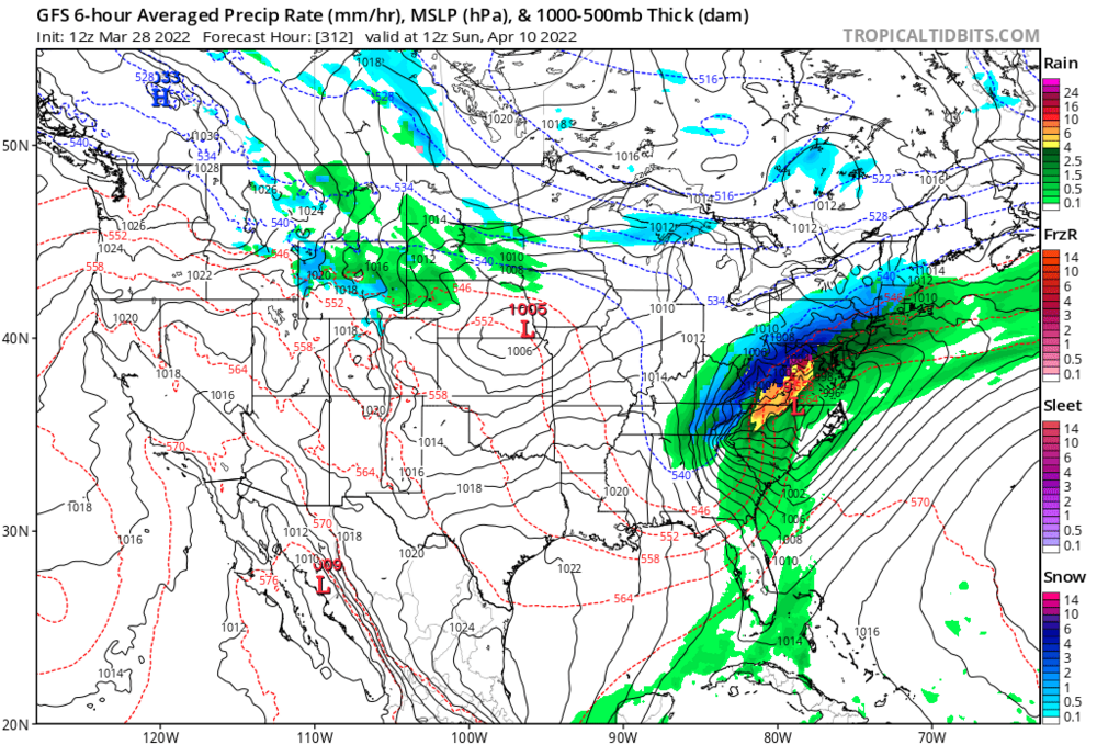
-
Western PA/Pittsburgh Winter 2021/22 Discussion
CoraopolisWx replied to meatwad's topic in Upstate New York/Pennsylvania
Nice rates with that line moving through. Snow globe outside -
Western PA/Pittsburgh Winter 2021/22 Discussion
CoraopolisWx replied to meatwad's topic in Upstate New York/Pennsylvania
Just got in from a measurement/walk. Averaged about 7.5-8” here in Mt Lebanon. Nice squall conditions out there, probably should’ve wore the mask though. -
Western PA/Pittsburgh Winter 2021/22 Discussion
CoraopolisWx replied to meatwad's topic in Upstate New York/Pennsylvania
How much enhancement the secondary wave provides, before the whole trough moves east will be key. -
Western PA/Pittsburgh Winter 2021/22 Discussion
CoraopolisWx replied to meatwad's topic in Upstate New York/Pennsylvania
Solid AFD from the NWS breaking down the storm. Might have to nap earlier to stay up for the best rates. -
Western PA/Pittsburgh Winter 2021/22 Discussion
CoraopolisWx replied to meatwad's topic in Upstate New York/Pennsylvania

-
Western PA/Pittsburgh Winter 2021/22 Discussion
CoraopolisWx replied to meatwad's topic in Upstate New York/Pennsylvania
Gfs not ready to cave...stays the course.


