

CoralRed
-
Posts
383 -
Joined
-
Last visited
Content Type
Profiles
Blogs
Forums
American Weather
Media Demo
Store
Gallery
Everything posted by CoralRed
-
Unexpected News from Williamsport. This would be our first snow worth counting as anything up here, with an extra inch the next day. Weather.com says back to 48/38 by Tuesday though. Yesterday afternoon we had some relief from the curse of PA grey in the afternoon with actual big patches of blue for a while but the way things look now, I think we will have the predicted all-day dreariness today. Ugh. Still have to be glad no precip or low temps for tonight here in PA or in NYC for ball drop. The unpredictable factor for NYC will be potential protestor disruptions. I hope they skip it but I am afraid they won't. Sat 06 | Night 31° 58% ENE6 mph Snow showers. Low 31F. Winds light and variable. Chance of snow 60%. Snow accumulating 3 to 5 inches.
-
This demands to be shared so here it is:
-
12:55a: A midnight surprise. I have been skeptical about Williamsport getting any snow due to temps. Earlier tonight NWS said low would be 33, about 5 degrees lower than earlier; Wunderground still says 38. So I am very surprised to see new Special Weather Statement calling for periods of heavy snow in certain places through 4a. They are putting very heavy emphasis on poor driving conditions. I am afraid lots of early drivers over here won't bother to recheck weather. They are talking lots more about driving hazards here than they usually do for a lot more snow. Hmmm. Special Weather Statement National Weather Service State College PA 1244 AM EST Mon Dec 11 2023 PAZ019-026>028-035-036-045-046-049-050-056-110945-Southern Centre-Huntingdon-Mifflin-Juniata-Fulton-Franklin-Southern Clinton-Southern Lycoming-Union-Snyder-Perry- 1244 AM EST Mon Dec 11 2023 ...SNOW TO IMPACT TRAVEL EARLY THIS MORNING... Rain has changed to wet snow across the higher elevations as of midnight and this changeover will work down to the valley floors by 2 AM. The formation of one or more nearly north to south bands of enhanced snowfall will create heavy snowfall rates of over 1 inch per hour through 4 am and drop the visibility down to just several hundred feet for a 15 to 20 minute period. Air and road Temperatures in the valley floors will remain at or just above freezing through 2 am, while higher elevations over 1400 feet above sea level will see the road temperatures drop to around 30 degrees with the road surface becoming snow and slush covered. This will lead to poor traction and much extended braking distance that will greatly increase the threat for accidents if good driving practices aren`t used. Persons traveling overnight should be alert for a wide range of visibility and road conditions. Allow extra time for travel and keep plenty of braking distance between you and the vehicle ahead. Postpone unnecessary travel if possible until late this morning.
-
After looking at the last few pages of comments, some of which lack our usual friendliness, I am going to go ahead and lapse into poetry. Before anyone panics, it will not be my poetry (I don't have any) but that of the Russian author Boris Pasternak, who wrote Dr Zhivago and I am sure knew a lot about snow and drinking, too. What could be better than to read First Snow while talking about it? First Snow Outside the snowstorm spins, and hides The world beneath a pall.* Snowed under are the paper-girl, The papers and the stall. Quite often our experience Has led us to believe That snow falls out of reticence, In order to deceive. Concealing unrepentantly And trimming you in white, How often he has brought you home Into the town at night! While snowflakes blind and blanket out The distance more and more, A tipsy shadow gropes his way And staggers to the door. And then he enters hastily... Again, for all I know, Someone has something sinful to Conceal in all this snow! ________ * Pall, noun: something that covers or conceals especially : an overspreading element that produces an effect of gloom
-
Forgot to post this earlier. Sorry. WYOU in Scranton/Wilkes-Barre is having a weather special starting in a few minutes at 7:30. Winter Weather Outlook will be a first as far as I know for a half hour show covering their snow predictions. Glad to see snow getting the attention it deserves. Maybe other stations will start doing this too. Update: I didn't see the middle as I was fussing with groceries and eating my donut. But I did see the end where they called for below average snow and possiblity of several Nor'easters coming up the coast. No snow map! Williamsport's average is just below 36" so we could be below average but still get a lot more than last year.
-
Just saw this irresistible picture which is far more interesting with its blemishes and colors than the typical moon shot. Definitely zoom it up and look closely when you get a chance as photographer advises. It reminded me an atmosphere like ours is a wonderful thing to have. It does not seem like a place for any advanced life from Earth to live however nor does anywhere else in our solar system, I'm afraid.
-
I thought at first he was doing a fantastic takeoff on kids today then I thought no, I think this is really him and not a made up character. What seemed so great as comedy was the opposite of funny in real life.
-
No more Freeze Warnings for us up in Williamsport. Montoursville Airport is now 30 and we are supposed to go down to 28. It is so strange to think that hit 75 just a week ago last Wednesday and I think the following day was 80. Plus of course on Sunday it will be completely dark before 5:30, I believe.
-
I was surprised to see when I got downstairs this morning that Williamsport was supposed to hit 69 or 70 later on. No such luck ... it never got past 62, which is what we are supposed to have tomorrow. Now that it is October 12, there won't be any more throwback weeks to summer where I have the windows open and it is in mid 70s or even low 80s for days. I will have to get used to fall being here to stay plus force myself to accept losing an extra hour of light soon, on November 5. Weather is such a heavy burden on the mind, isn't it?
-
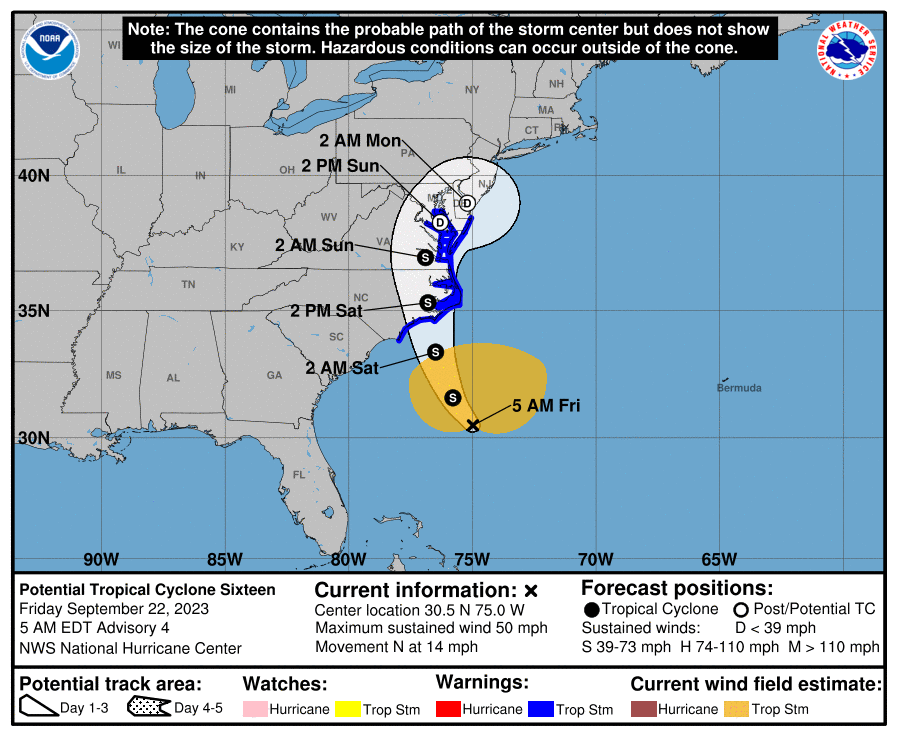
4:50a I see PA made the cone. I wonder when that last happened? I was in Jersey City where I had lived for years, just 10 blocks from the Hudson and a few blocks from NY Harbor for Superstorm Sandy. I went down by the river and the harbor for the last time before it hit during the late afternoon of the day before, I think. I wish I could say I remember it well but I don't. There wasn't much going on as I expected but I wanted to see for myself. I kept going around the neighborhood and down to the river that weekend trying to imagine what would happen. I ended up talking to and then kind of clinging to a cleaning lady from a nearby building also there. We shouted our good-byes. Lucky you will have your new girlfriend to cling to as necessary. I am definitely interested in seeing a video and hearing about what you see.
-
You raise some interesting points. What countries have weather satellites focused on the Mediterranean? What countries track these storms and issue warnings? Don't the Big European Three of UK, France and Germany provide sufficient information and coverage for the smaller and/or poorer countries to the East?
-
The sun was shining again in Williamsport at 7:00p. Montoursville Airport rain seemed low at around .3 so I checked two weather stations in Williamsport on Wunderground at they were .44 and .55. We never did get any lightening after all that earlier thunder. Local TV news is full of reports about Nanticoke and a fair getting hit by strong winds and have some damage. Some power outages in counties in northcentral and NEPA including my own of Lycoming but I do not know where. We up here will have more rain locally over the next week just like the rest of you but that will be competing for my attention with the already remarkable Hurricane Lee. It will be something if we get any rain or wind from it, even indirectly.
-
The rain has finally started to fall in Williamsport after more than an hour and a half of thunder but no rain and half dark clouds-half blue skies with white clouds. The lights in the parking lot just came on at 3:25. Still thunder but no lightening -- yet. Air seems so cool yet I see we are at 86, not much of a drop at all.
-
You really think so? Seriously, what are the chances?
-
I can tell you guy on Channel 16 brought it up at 11:00p forecast on Labor Day as something that could possibly affect us depending on track. He kind of dismissed it as unlikely but still he brought it up. I kept seeing things about Lee all day I didn't want to see. And we still have plenty of time for more bad hurricanes this year.
-
The Williamsport-Pittsburgh bus used to stop there when I was going to school in Pittsburgh and the two years I lived there after graduating. I know it did. I am sure of it. Nevertheless I cannot remember a darn thing about Dubois. I can remember a bit about Punxatawny, home of Punxatawny Phil the groundhog of course, but who knows if that is really from my bus trips or from seeing the Bill Murray movie they filmed there on TV through the years?
-
It has been raining with thunder and lightening in Williamsport for a few hours now. Lights flickered briefly and TV switched off but cable box stayed on. The Weather Channel was constantly sounding off over flood warning & some other things too for about two hours but now I turned to another channel and i am relaxing again without any toots. Yes it is annoying to have local weather interfere with my plans to watch hurricane coverage.
-
Complete waste of time graphic then, wasn't it? Thanks for letting me know.
-
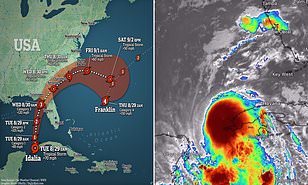
So is what we see in the graphic on the left going to happen? I saw this at dailymail.com but the article didn't discuss it. If the two storms interacted in the Atlantic, what would happen?
-
Wow! I looked this HAFS A up and it is new, which most of you probably already knew. What do you all think about this prediction? It sure isn't what people down there want.
-
Williamsport report matches the rest of you to our south. We are in a state of breezy perfection: blue skies, 75 and dewpoint of 50. I am very happy for all the locals and out of towners here for Little League. This week's weather has been pretty good for them and next week's 70s will be even better. Last night we had rain rain rain once the sun went down. We got about 2.5" instead of predicted half an inch or so.
-
I know I want another mostly not too hot summer next year and every year, really. I don't have AC so I felt beyond lucky and relieved when that first, truly awful first round of smoky air came our way in early June, I could help myself just by keeping my doors and windows closed. I could gladly do a cheer: Below average temperatures, Below average temperatures, Yeah!! over that memory.
-
Funny to read this while watching end of Twister, the ultimate weather geek movie. Either someone has had a bad day or an anti-weather geek managed to get hired at NWS: SHORT TERM /6 AM TUESDAY MORNING THROUGH WEDNESDAY/... As the rain moves away, there won`t be much of a break before showers move back through as the tail end of the storms systemd Drags a short wave across the lower lakes on Tuesday. All of this nonsense moves out for Wednesday with a nice day in store.
-
I just looked at the 3 day history. Williamsport got a out a quarter inch of rain on the 10th and half an inch yesterday. Pretty normal but of course we haven't been very normal for a long time on rain. Maybe we will be this fall or in the winter. I first noticed that we were having more sunny days and I was waking up to a lot less of the usual PA grey skies around this time or a bit earlier in 2020. That is a long time to have more sun & less rain.
-
Sorry if someone else already talked about this. I just saw this at Twitter and knew many year will be thrilled to hear about this upgrade. "The Department of Commerce and NOAA expanded the capacity of the nation’s Weather and Climate Operational Supercomputing System (WCOSS) by 20% this week. The increased computing power and storage will help improve forecast model guidance for years to come and allow for other weather prediction advances. “Our investment in high-performance computing will pay off with better U.S. weather modeling,” said Michael C. Morgan, Ph.D., assistant secretary of commerce for environmental observation and prediction. “Forecast model upgrades made possible by this increased computing capacity will bring improved and timely forecasts and warnings that better protect life and property.” https://www.noaa.gov/news-release/noaa-completes-upgrade-to-weather-and-climate-supercomputer-system


