CoralRed
-
Posts
383 -
Joined
-
Last visited
Content Type
Profiles
Blogs
Forums
American Weather
Media Demo
Store
Gallery
Everything posted by CoralRed
-
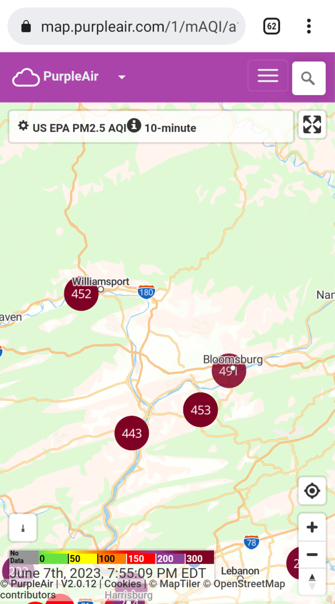
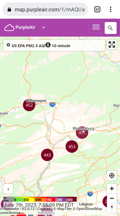
Hi. Thanks for responding to my post. Could you retry giving me the link about the wildfires in Wisconsin? It is the strangest thing but when I click on it. I keep bringing up the last image I had in my post, the one I saved last year of the Purple Air numbers near me. Thanks a lot.
-
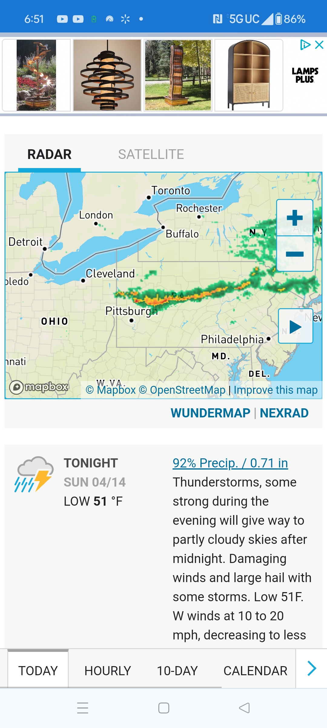
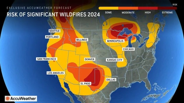
3:15a: Williamsport's story is also one of getting much more rain than than predicted. Montoursville Airport already has .7 since evening and we were only supposed to get .25. On the other hand, the .13 for later today is less than I think was originally predicted. It has been coming down fairly hard for hours. Update: We have another .48 at 5.08a. Still more to come "Rain, mainly before noon... between a quarter and half of an inch possible." Looking ahead to the summer, I saw this map earlier today. I think AccuWeather should have included all of Canada since smoke comes down here from Northern Canada too. https://www.accuweather.com/en/weather-forecasts/canada-wildfire-smoke-is-creating-unhealthy-air-quality-in-the-northern-us/1649945#google_vignette Laughs from Alberta, Canada: "they have an abundance of resources for this fire" so please tell me why they haven't used them yet? Those flames too close to the houses. In case anyone was wondering, some of us will never forget the smoke of early June 2023. Who can believe it has been almost a year?
-
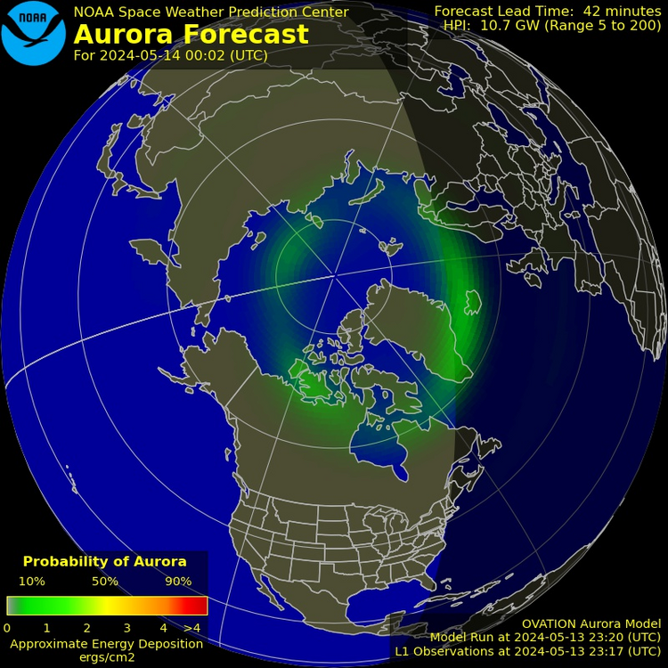
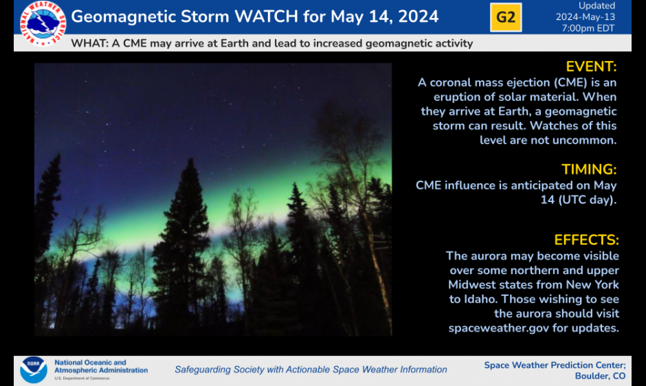
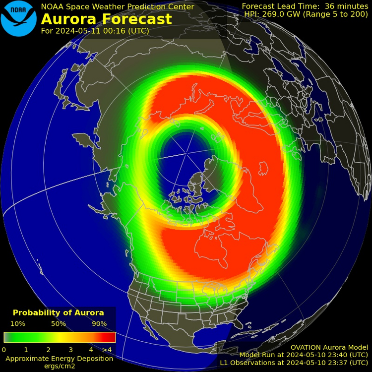
Northern Lights! #4 7:10p: ABC Nightly News just said a few states will have another chance to see them tonight according to NOAA. They include a few Midwestern states including Wisconsin and Upstate New York and Maine in the East. Best time to see: 3a. I will be up then I think; we will have around 50% cloud cover then. Right now we have 29% and it is pretty sunny out. I am figuring I won't see anything later but maybe I could get lucky. Things sure don't look promising but I guess NOAA expects things to change. It seems strange to think how we in Williamsport and other places in PA missed this wonderful phenomena that so many others in dozens of countries saw on Friday including people less than 75 miles away all because of cloud cover. It just wasn't meant to be, I guess. This what we have to work with right now: Update 7:28p G2 WATCH IN EFFECT FOR MAY 14 published: Monday, May 13, 2024 23:01 UTC Another CME may arrive at Earth and lead to increased geomagnetic activity.
-
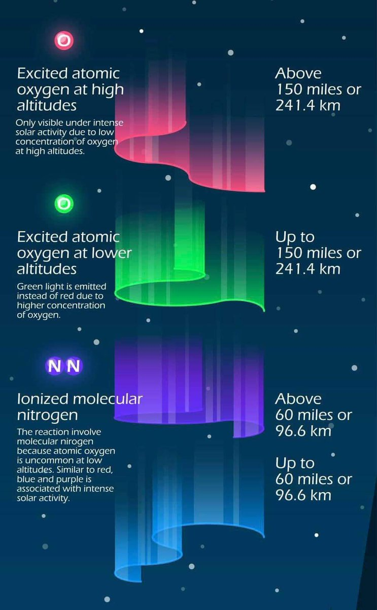
In case like me you wondered what was up with the different colored Northern Lights. https://x.com/Montross85_WX/status/1789479139021664317

-
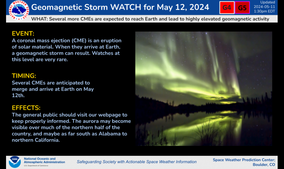
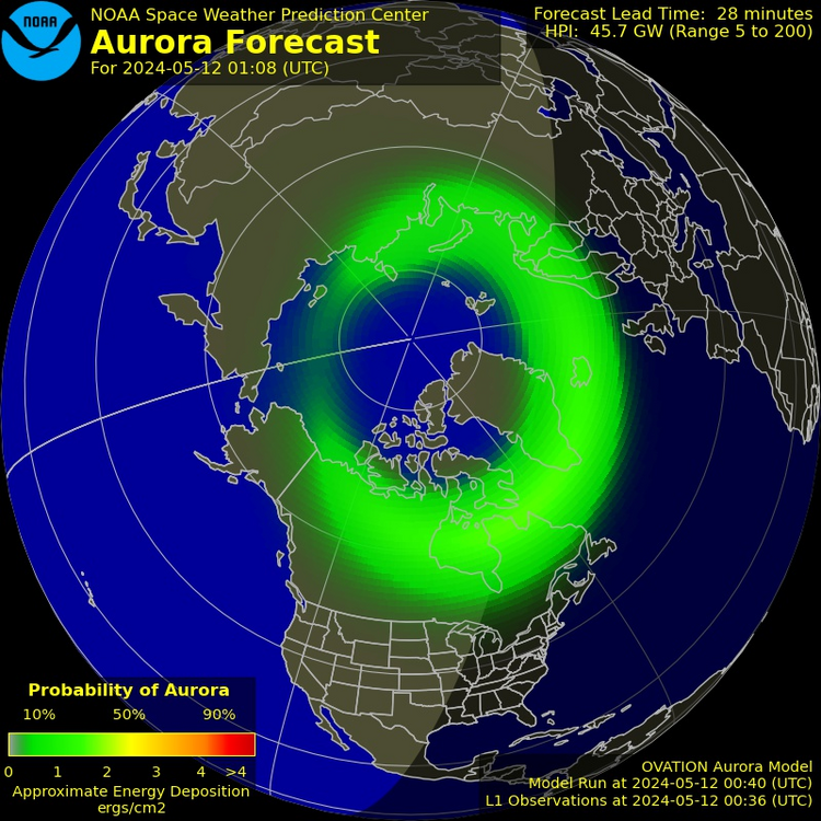
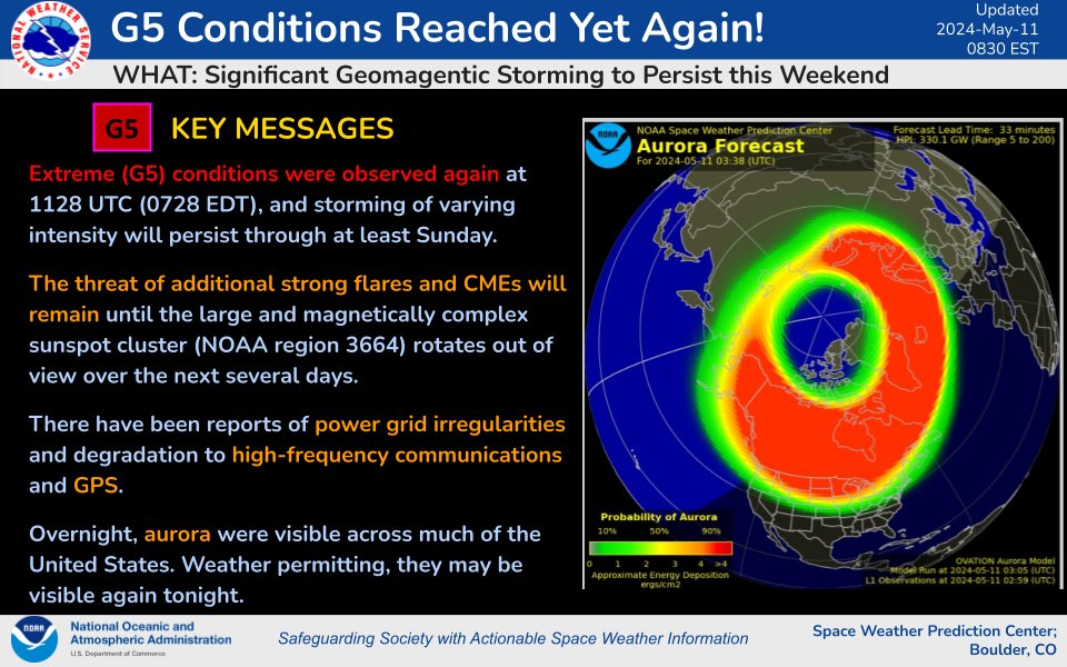
Northern Lights! #3. Looks like nothing happening in US tonight. BUT things will be popping again tomorrow starting during the day. Space Weather put out a new watch this afternoon. SEVERE AND EXTREME (G4-G5) GEOMAGNETIC STORMS LIKELY ON 12 MAY 2024 published: Saturday, May 11, 2024 17:54 UTC Another series of CMEs associated with flare activity from Region 3664 over the past several days are expected to merge and arrive at Earth by midday (UTC) on 12 May. Periods of G4-G5 (Severe-Extreme) geomagnetic storms are likely to follow the arrival of these CMEs.
-
Northern Lights! #2: Looks like the geomagnetic storm may stick around longer. Williamsport's cloud cover is supposed to be bad for several more days-plus we are supposed to get .5" rain tonight-so I doubt i will get to see them. I am hoping some of you will. Very important tip I saw mentioned numerous times. I am passing it along for people who will have much clearer skies Saturday and Sunday nights. "You Can Get a Better View of the Northern Lights With Your Phone The aurora display may be visible on your phone, even when it's not to the naked eye" https://lifehacker.com/tech/how-to-view-northern-lights-with-smartphone
-
Northern Lights! I see others were surprised to see them on 11 o'clock News too. Cloud coverage unexpectedly did or may breakup in different places in our part of PA. Williamsport is supposed to stay at 90% or higher overnight. Here is current satellite. Maybe someone here can see them where they are and maybe get a picture now or later tonight. But seeing them in person is most important thing. I never thought I'd ever get a chance to do that here. Seems so strange to think I could see them if clouds weren't in my way.

-
No one is talking about the geomagnetic storm that I didn't know about until last night. Not much warning. It is 7:20p now so we will soon know better what will be coming. "Scientists will know how severe the storm will be at around around 8 pm ET when the explosions of plasma racing through space will be nearly one million miles from our planet - and NOAA plans to issue alerts immediately." This can go on a few days, potentially affecting power, communications and GPS. Places that normally do not see Northern Lights might see them. Doesn't look like we will get lucky. https://www.dailymail.co.uk/sciencetech/article-13404835/cannibal-solar-storm-gps-power-outage.html There is an official NOAA website for space weather believe it or not. Here is the link: https://www.swpc.noaa.gov/
-
Evening perfection here in Williamsport. Skies light blue mixed with dull white clouds and lots of sun at 6:40p. Breezy and pleasant inside with front door partially opened. 83 with low humidity. If only the whole summer could be like this moment. Also no unpleasant news from outside world bothering me at all. Wish that would last whole summer too. Me with my crossed legs outstretched, relaxed and not thinking of anything really. Just enjoying.
-
Great day for an anniversary. Warm and blue skies. I hope you and your wife enjoy it.
-
I don't recall ever seeing the same word over and over like this for all days and nights except for this afternoon and one day for variety says rain not showers. Lots to look forward to up here in Williamsport! And guess what? For the Friday, Saturday and Sunday after this in their 10 day, Wunderground has showers! This Afternoon Mostly cloudy, with a high near 76. Southeast wind around 9 mph. Tonight A chance of showers, mainly after 11pm. Mostly cloudy, with a low around 51. Southeast wind 9 to 11 mph. Chance of precipitation is 30%. New precipitation amounts of less than a tenth of an inch possible. Saturday Showers likely before 10am, then a chance of rain after 10am. Cloudy, with a high near 55. Southeast wind 8 to 11 mph. Chance of precipitation is 60%. New precipitation amounts between a quarter and half of an inch possible. Saturday Night Rain likely, mainly after 2am. Cloudy, with a low around 49. Southeast wind 10 to 13 mph. Chance of precipitation is 70%. New precipitation amounts between a tenth and quarter of an inch possible. Sunday Showers. High near 58. Southeast wind around 11 mph. Chance of precipitation is 90%. New precipitation amounts between a quarter and half of an inch possible. Sunday Night Showers likely, mainly before 8pm. Patchy fog after 2am. Otherwise, cloudy, with a low around 55. Chance of precipitation is 60%. New precipitation amounts of less than a tenth of an inch possible. Monday Scattered showers, mainly after 2pm. Patchy fog before 8am. Otherwise, mostly cloudy, with a high near 75. Chance of precipitation is 30%. Monday Night Scattered showers, mainly before 8pm. Mostly cloudy, with a low around 56. Chance of precipitation is 30%. Tuesday Scattered showers, mainly after 2pm. Partly sunny, with a high near 76. Chance of precipitation is 40%. Tuesday Night Scattered showers. Mostly cloudy, with a low around 59. Chance of precipitation is 50%. Wednesday Showers and thunderstorms likely. Partly sunny, with a high near 79. Chance of precipitation is 60%. Wednesday Night Showers and thunderstorms likely. Mostly cloudy, with a low around 60. Chance of precipitation is 60%. Thursday Showers. High near 74. Chance of precipitation is 80%.
-
.CLIMATE... Record high temperatures were set at the following locations today (Monday): SITE 2024 OBS PRVS RECORD Altoona 86F 83F (1956) Bradford 82F 76F (1984) Williamsport 89F 86F (1942/1974) Copied this from weather.gov. Someone earlier mentioned record was broken for Lancaster. I wonder why it wasn't on this list?
-
8 am Visibility 0.08 miles I didn't know we could measure visibility that precisely. I realized overnight it was murky outside. Yet I checked a few times and never saw any advisories or statements about fog.
-
Williamsport at 10:23p has cooled down from 78 earlier to 63. Tomorrow should be record breaking 86/62. .11 of the thunderstorms and rain on Tuesday is now supposed to come around my 2:15 dental appointment. Fingers crossed I don't end up in a downpour.
-
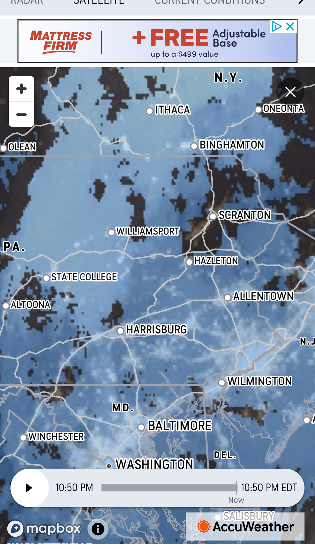
Just looked at weather map for first time since this afternoon. Wasn't expecting that very long stretch of watches and warnings to still be up in the Midwest at 10:30. It has seemed that the furnace has gone on constantly all day. I guess I am surprised to hear it since we are going to hit 80 tomorrow. As others have said, it seems strange to go from 50s to 80s.
-
Great shot! In Williamsport we have been pretty quiet on the lightening and thunder since last year but it is getting to be that time of year again.
-
Wow! People here waited too long to pull over and ended up way too close to the tornado. Tornado could have easily gotten them with just a slight movement. No amount of likes from a later video on the internet erases the fact that tornadoes are never your friends. Thanks for sharing but I hope these people learned their lesson.
-
You are right for me: No big coastal winds are going to reach here in Williamsport. But others in PA are much further east and could get some leftovers that are pretty strong. I am not afraid of a second round of Sandy. The way above average heat already predicted for July and August and the rains possibly coming our way this summer and maybe not just once would be my concerns. Plus we can get indirectly affected by what goes on in other places. We were last summer with Canadian smoke. I guess I just don't like anything interfering with my vision of Williamsport as a place of no extremes, weather or otherwise.
-
I thought maybe this was a joke or you meant Penn State. But I looked it up and found free Washington Post article all about the Penn team. "The new forecast, issued Wednesday, calls for a range of 27 to 39 named storms, with a best guess of 33. The most on record was 30 named storms in 2020." North Atlantic ocean temps have hit highs for the past 419 days. This is shown in great chart in article using top solid black line for 2024 and orange line below that for 2023. It is impossible for me not to think I and others here am going to get something we won't like out of the predicted very high land and ocean heat this summer. Not nearly as bad as Sandy when I lived (second floor thank God) a brief walk from Hudson River & NYC Harbor in downtown Jersey City but something. I didn't expect to feel that way when I moved back to Williamsport in 2015. https://www.msn.com/en-us/weather/other/forecast-group-predicts-busiest-hurricane-season-on-record-with-33-storms/ar-AA1nBEbz
-
Turns out we have had a wildfire statement up for a few hours. Seems strange after all the rain we had but of course it is what it is. Special Weather Statement Special Weather Statement National Weather Service State College PA 315 PM EDT Tue Apr 23 2024 PAZ004>006-010>012-017>019-024>028-033>037-041-042-045-046- 049>053-056>059-063>066-240000- Warren-McKean-Potter-Elk-Cameron-Northern Clinton-Clearfield- Northern Centre-Southern Centre-Cambria-Blair-Huntingdon-Mifflin- Juniata-Somerset-Bedford-Fulton-Franklin-Tioga-Northern Lycoming- Sullivan-Southern Clinton-Southern Lycoming-Union-Snyder-Montour- Northumberland-Columbia-Perry-Dauphin-Schuylkill-Lebanon- Cumberland-Adams-York-Lancaster- 315 PM EDT Tue Apr 23 2024 ...ELEVATED RISK OF WILDFIRE SPREAD THIS AFTERNOON... A combination of dry fuels, low relative humidity and windy conditions this afternoon will create an elevated risk of wildfire spread across much of Central Pennsylvania. Minimum relative humidity values will range from 20 to 30 percent accompanied by wind gusts between 20 and 30 mph from the south- southwest.
-
Next Monday, April 29, up here in Williamsport may be a record breaker as well. Right now Wunderground is calling for a high of 85. Historic high for the 29th is 86. I hate the yearly switch to when max highs are awful and you would give anything for some relief. We are not there yet but it is coming. As for today, high was 70 and is now 68. I will close the open door soon. I have enjoyed the fresh air the higher temps have allowed me to bring into the house a few times recently. Many more open door and then open window days to come of course.
-
Slow start this morning and I am still up at 6:00a so I will go first. We dropped to 32 overnight and there is a Freeze Watch for tonight so my wish to not go below 34 in Williamsport again this spring will obviously not come true. Frost and temps under 35 mentioned for Sunday, Monday, Wednesday and Thursday nights this week. Some days with some sun, thank goodness. Next Sunday 73/55.
-
2:15a: Frost Advisory. Already 34 here in Williamsport, our ppl predicted low for the night. I hope it doesn't get lower this spring. Our local farmers have had too many weather problems in recent years. Weather.com headline last week said July and August may be among the hottest we have ever had. I saw numerous times on Twitter this winter that sea temps were very high. More recently the hurricane predictions were for very active season. I will stop the doom and gloom report now.
-
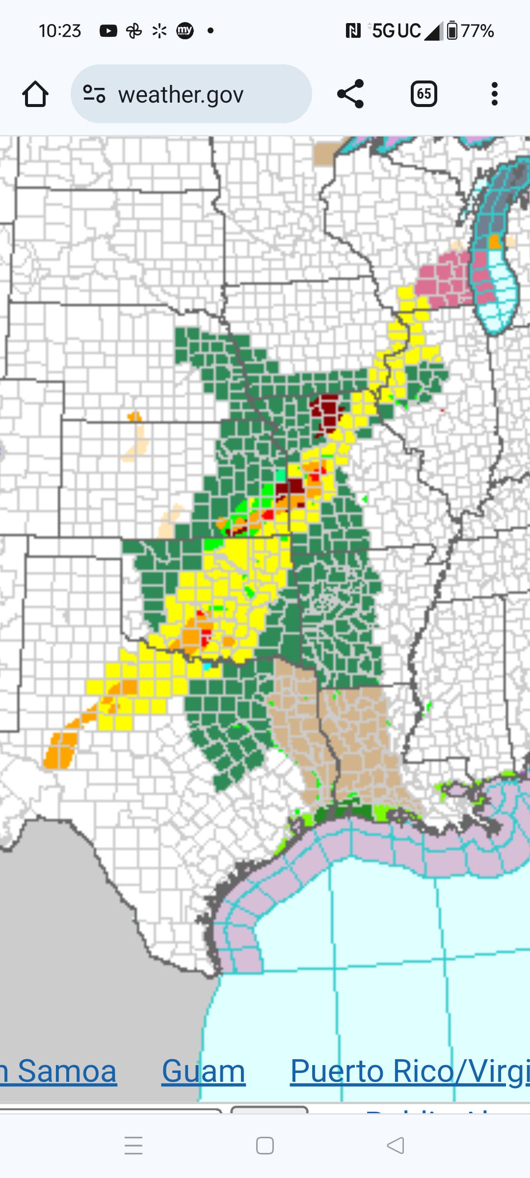
We didn't end up getting a big show here at all. Some of everything except I guess hail but only at say medium to strength. I hope you will have same good luck. I am assuming there will not be a Round 2 here This looks promising with only 40% chance of precip for Harrisburg. Last updated at 6:00: Detailed Forecast Tonight A chance of showers and thunderstorms before 2am, then a slight chance of showers between 2am and 3am. Some storms could be severe, with damaging winds. Increasing clouds, with a low around 60. West wind 7 to 16 mph, with gusts as high as 29 mph. Chance of precipitation is 40%. New rainfall amounts of less than a tenth of an inch, except higher amounts possible in thunderstorms.
-
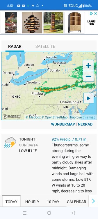
I would think so. Here is what I have right now on Wunderground.com.