dta1984
-
Posts
1,732 -
Joined
-
Last visited
Content Type
Profiles
Blogs
Forums
American Weather
Media Demo
Store
Gallery
Everything posted by dta1984
-
Let's hope things look a little better once we get closer.
-
Another pretty good run, thru next Tues. Looks like several potential chances over the next week.
-
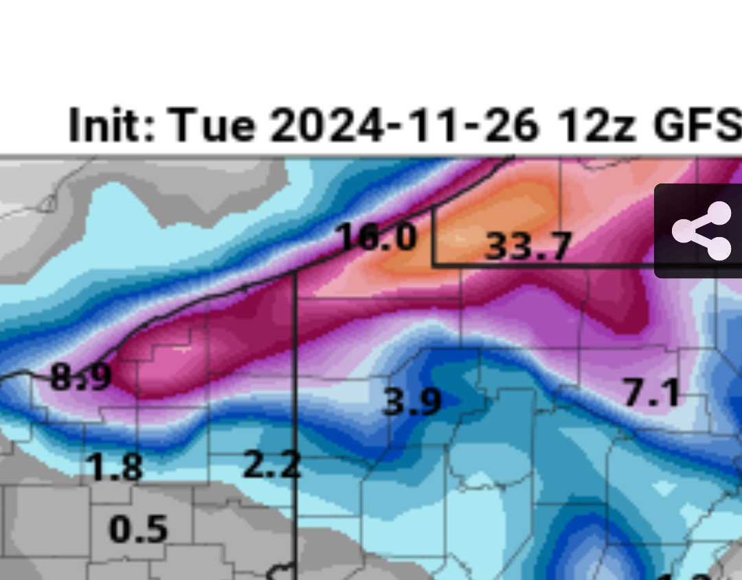
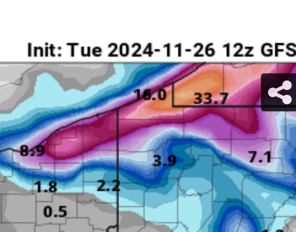
Last several days of GFS and euro runs have been really good for neoh lake effect next week. Canadian looks to keep the heaviest to the north, but other models seem to spread the wealth a little more. Been a few years since we have had a prolonged multi day early season event.
-
I measured 1.5" yesterday evening. Not sure if the main lake band ever came this way overnight and added to that or not... All rain now. Definitely nice to see the snow again. Next weekend looks interesting!
-
It was nice seeing the snow this morning, probably had 1/2" or so in the grass. WWA for 3-5" tonight. The short rangers look great for eastern Cuyahoga and western Geauga.
-
Sure would! Definitely an odd setup. Hopefully we can get temps to cooperate. Either way, there's definitely a signal for some wintry weather possibilities end of next week and Thanksgiving week.
-
What an incredible stretch of late October weather. Couldn't ask for better weather for leaf clean up...dry and mild.
-
After a rather warm and dry early fall, It's been a fast jump to late fall weather early this week with Low 40s and Le rain. Looks like a pleasant end to the week though, don't want to cool off the lake too fast.
-
The storms this afternoon sure looked nasty and sounds like there may have been a few tornadoes as well. Mostly just heavy rain and winds here.
-
The rain and majority of the clouds cleared out pretty quickly this morning. With just scattered clouds this afternoon , we should have pretty good eclipse viewing!
-
Just noticed Pivotal has a dedicated section for the Eclipse. You can toggle states, models and view precipitation or cloud cover %. It's still early , but fun to look at. https://www.pivotalweather.com/eclipse2024/?m=epsens&p=cloudcover_tle_4-mean&r=us_state_oh
-
I took several measurements between 8.5" - 9" off of my deck. Now, back to the 60s this week
-
WSW for Sunday, maybe 6"+? Quite the rollercoaster, going from flooding rains Saturday to Heavy snow on Sunday, then back to 60s next week.
-
Definitely a nice surprise. Just under 6" here so far.
-
Looks like a 290 flow which generally does pretty well out here.
-
Couldn't agree more. After whatever snow chance we have Fri-the weekend, I'm ready for spring unless it's a blockbuster storm in March. Done with these 1-2" marginal events.
-
True, at least it's something. What a clunker it's been... again. I'll enjoy the 50s for the next few days, it's been nice getting a taste of spring.
-
I measured 2.75" additional since last measurement 12 hrs ago. Storm total here is 9.25". The lake effect definitely made up for Thursday's miss!
-
Measured 6.5", and that would be my total so far. On and off bursts of snow this morning, looks like some nw flow le trying to form.
-
Sounds like you need a new weather app. I have wunderground, it's ok, but I recommend also using the NWS CLE website (and their social media) as that's just focused on our area.
-
Agreed! We are due for a good one, hopefully this is it. Always enjoy ready the OHweather nws discussions
-
Good to hear this! Looks like there should be several opportunities for system and lake enhanced/effect snow Thurs -Sat.
-
I came up with right at 7" of snow. Very scenic outside just in time for Christmas. Should stick around until the end of the week at least.
-
Trends are looking good for Mon-Tues. Would be nice if what falls could stick around until Christmas...
-
Ya looking like Tues is the better day away from the lake. Hoping for the band to slow down as it gets our way.