AppsRunner
-
Posts
2,420 -
Joined
-
Last visited
Content Type
Profiles
Blogs
Forums
American Weather
Media Demo
Store
Gallery
Everything posted by AppsRunner
-

Pre-Christmas (Dec 21-23rd) Winter Storm Part 2
AppsRunner replied to Chicago Storm's topic in Lakes/Ohio Valley
I haven't looked at any guidance tonight but DEN recorded 0.12" in an hour while the temperature was -9F so clearly this storm will overperform. -
Pre-Christmas (Dec 21-23rd) Winter Storm Part 2
AppsRunner replied to Chicago Storm's topic in Lakes/Ohio Valley
Made this one myself, hope you enjoy. -
Pre-Christmas (Dec 21-23rd) Winter Storm Part 2
AppsRunner replied to Chicago Storm's topic in Lakes/Ohio Valley
Yep, and now I only know how to forecast NW flow jet bands and upslope. But now who will tell me my TAFs are bad? -
Pre-Christmas (Dec 21-23rd) Winter Storm Part 2
AppsRunner replied to Chicago Storm's topic in Lakes/Ohio Valley
That's not particularly surprising. The ARW cores have that tendency vs NMM. We see it a lot in Colorado. I wouldn't put much faith into it anyways since it's the SREF but it sure is fun to look at sometimes -
Pre-Christmas (Dec 21-23rd) Winter Storm Part 2
AppsRunner replied to Chicago Storm's topic in Lakes/Ohio Valley
Quick, someone post the new SREF -
Pre-Christmas (Dec 21-23rd) Winter Storm Part 2
AppsRunner replied to Chicago Storm's topic in Lakes/Ohio Valley
Early trends are... not great, unless you want it to snow in Cleveland. -
Pre-Christmas (Dec 21-23rd) Winter Storm
AppsRunner replied to Chicago Storm's topic in Lakes/Ohio Valley
I thought this storm was already over? -
Pre-Christmas (Dec 21-23rd) Winter Storm
AppsRunner replied to Chicago Storm's topic in Lakes/Ohio Valley
-
Pre-Christmas (Dec 21-23rd) Winter Storm
AppsRunner replied to Chicago Storm's topic in Lakes/Ohio Valley
The ECM ensemble continue a slightly weaker/slower evolution through the Ohio valley and is at least a slight jog east. The STL-IND-DTW track feels like a reasonable middle ground for now. I'll still take the over for ALEK. -
Pre-Christmas (Dec 21-23rd) Winter Storm
AppsRunner replied to Chicago Storm's topic in Lakes/Ohio Valley
This run did not show exactly what I wanted, so it is clearly wrong. -
Pre-Christmas (Dec 21-23rd) Winter Storm
AppsRunner replied to Chicago Storm's topic in Lakes/Ohio Valley
Proud of the GFS for managing to be west of the NAM -
Outside of Tuesday the long range pattern looks hot through the majority of September. How far will we go into October before we see snow?
-
That small circulation just to the west of KLOT looks like trouble. No obvious TDS but its also got 90kt at 450ft so it's gonna produce damage one way or the other.
-
Arguably stronger winds behind the main line, DVN gust to 75kt a few minutes ago.
-
Again back by Des Moines, but getting some better resolution photos out there.
-
The ratio of sig severe gusts in this has been extremely impressive. This has to be a high risk upgrade at some point soon. They put out the 1630 update early, surely an early-issue 20z high is in the cards.
-
Local Storm Report by NWS DVN: 4 ENE Shellsburg [Linn Co, IA] emergency mngr reports TSTM WND DMG at 12:58 PM CDT -- estimated gusts over 100 mph with multiple campers blown over, along with the shelter roof at the park blown off.
-
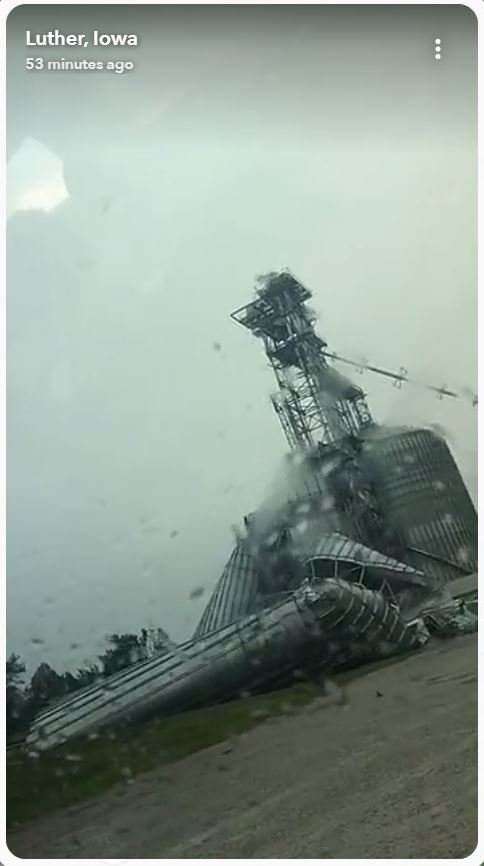
Taken back in Luther, but this in that area of 110kt velocity northwest of DMX.

-
Seems as if Tama county has had the worst winds so far, EM reporting up to 100mph gusts there. At least for DMX's CWA most of the larger cities (DSM/Ames) have siren activation for any warning with 70+
-
METAR obs. don't show much all the time, especially if it's windy like it is now.
-
Historic Tornado Outbreak April 27, 2011
AppsRunner replied to CUmet's topic in Weather Forecasting and Discussion
You should be able to get ECMWF 850mb DP's on Plymouth's site as well.