jayyy
-
Posts
4,542 -
Joined
-
Last visited
Content Type
Profiles
Blogs
Forums
American Weather
Media Demo
Store
Gallery
Everything posted by jayyy
-
3/12 Event: Winters Last Hurrah at Least East of Mountains
jayyy replied to Weather Will's topic in Mid Atlantic
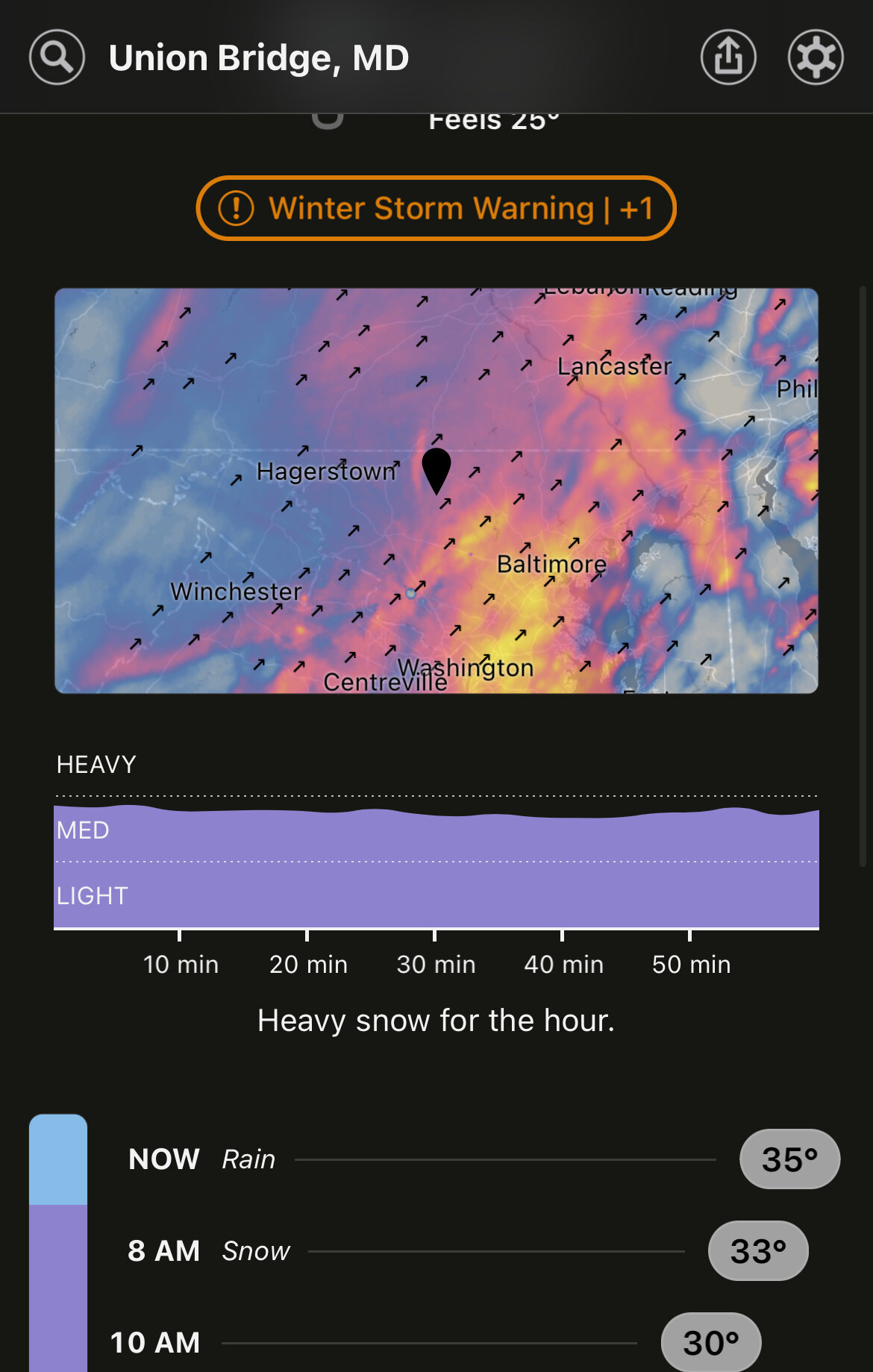
The cold is awfully close to catching all of that intense precip near Baltimore -
3/12 Event: Winters Last Hurrah at Least East of Mountains
jayyy replied to Weather Will's topic in Mid Atlantic
Can it do this forever? -
3/12 Event: Winters Last Hurrah at Least East of Mountains
jayyy replied to Weather Will's topic in Mid Atlantic
I’d say you woke up at the perfect time. -
3/12 Event: Winters Last Hurrah at Least East of Mountains
jayyy replied to Weather Will's topic in Mid Atlantic
Mainly snow there -
3/12 Event: Winters Last Hurrah at Least East of Mountains
jayyy replied to Weather Will's topic in Mid Atlantic
Ellicott city folks should be flipping momentarily -
3/12 Event: Winters Last Hurrah at Least East of Mountains
jayyy replied to Weather Will's topic in Mid Atlantic
33 degrees, heavy snow, very low visibility -
3/12 Event: Winters Last Hurrah at Least East of Mountains
jayyy replied to Weather Will's topic in Mid Atlantic
Winds are roaring out there -
3/12 Event: Winters Last Hurrah at Least East of Mountains
jayyy replied to Weather Will's topic in Mid Atlantic
Wait for it…. 8 am youll be in the upper 30s -
3/12 Event: Winters Last Hurrah at Least East of Mountains
jayyy replied to Weather Will's topic in Mid Atlantic
There’s heavy snow in Kentucky and Tennessee and NWS just put up a SWS for 1-2” / hr rates. Think we’re ok. -
3/12 Event: Winters Last Hurrah at Least East of Mountains
jayyy replied to Weather Will's topic in Mid Atlantic
Back edge approaching? -
3/12 Event: Winters Last Hurrah at Least East of Mountains
jayyy replied to Weather Will's topic in Mid Atlantic
Rain snow line on your doorstep. It started mixing with snow at 38 here -
3/12 Event: Winters Last Hurrah at Least East of Mountains
jayyy replied to Weather Will's topic in Mid Atlantic
Never want to hear anything about warm grounds again after this lol -
3/12 Event: Winters Last Hurrah at Least East of Mountains
jayyy replied to Weather Will's topic in Mid Atlantic
District of Columbia-Carroll-Northern Baltimore-Cecil- Southern Baltimore-Prince Georges-Anne Arundel-Charles- Northwest Montgomery-Central and Southeast Montgomery- Northwest Howard-Central and Southeast Howard-Northwest Harford- Southeast Harford-Prince William/Manassas/Manassas Park-Fairfax- Arlington/Falls Church/Alexandria-Eastern Loudoun- Including the cities of Washington, Eldersburg, Westminster, Reisterstown, Cockeysville, Elkton, Baltimore, Bowie, Suitland-Silver Hill, Clinton, College Park, Greenbelt, Laurel, Camp Springs, Glen Burnie, Annapolis, Severn, South Gate, Severna Park, Arnold, Odenton, St. Charles, Waldorf, Germantown, Damascus, Bethesda, Rockville, Gaithersburg, Silver Spring, Lisbon, Columbia, Ellicott City, Jarrettsville, Aberdeen, Dale City, Manassas, Woodbridge, Lake Ridge, Montclair, Reston, Herndon, Annandale, Centreville, Chantilly, McLean, Franconia, Arlington, Alexandria, Falls Church, Leesburg, Ashburn, and Sterling 646 AM EST Sat Mar 12 2022 ...RAPIDLY DETERIORATING CONDITIONS THIS MORNING... Rain will change to snow over the Washington and Baltimore Metropolitan areas as well as northeastern Maryland by 9 AM this morning from northwest to southeast. Snowfall rates around one to two inches per hour are expected through late this morning along with rapidly falling temperatures below freezing. Despite the recent warm conditions, snow is expected to stick on many surfaces, causing travel disruptions. Strong northwest winds with gusts around 45 to 55 mph are expected during this time, causing snow and possible blowing snow to reduce visibility below one-half mile at times. Near blizzard conditions are expected. Please use extra caution if you have to travel. TASTY -
3/12 Event: Winters Last Hurrah at Least East of Mountains
jayyy replied to Weather Will's topic in Mid Atlantic
Damn skippy
-
3/12 Event: Winters Last Hurrah at Least East of Mountains
jayyy replied to Weather Will's topic in Mid Atlantic
I was at 43 and rain an hour before I was at 36 and heavy snow. It comes in like a bat out of hell. -
3/12 Event: Winters Last Hurrah at Least East of Mountains
jayyy replied to Weather Will's topic in Mid Atlantic
Puking out there right now. Color me satisfied.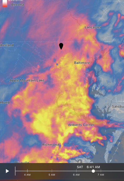
-
3/12 Event: Winters Last Hurrah at Least East of Mountains
jayyy replied to Weather Will's topic in Mid Atlantic
T minus 20 minutes -
3/12 Event: Winters Last Hurrah at Least East of Mountains
jayyy replied to Weather Will's topic in Mid Atlantic
Down to 40 in Ellicott city. Heavy snow by me. It happens quick. It’s coming -
3/12 Event: Winters Last Hurrah at Least East of Mountains
jayyy replied to Weather Will's topic in Mid Atlantic
That’s because it’s snow. -
3/12 Event: Winters Last Hurrah at Least East of Mountains
jayyy replied to Weather Will's topic in Mid Atlantic
Ellinwood!!! -
3/12 Event: Winters Last Hurrah at Least East of Mountains
jayyy replied to Weather Will's topic in Mid Atlantic
Lol, this is wild. Went from rain to 15 minutes of a mix to near blizzard conditions within a half hour span. -
3/12 Event: Winters Last Hurrah at Least East of Mountains
jayyy replied to Weather Will's topic in Mid Atlantic
Dumping an 80/20 snow sleet mix. Just about fully changed over -
3/12 Event: Winters Last Hurrah at Least East of Mountains
jayyy replied to Weather Will's topic in Mid Atlantic
We’re a bit ahead of schedule on the flip. Tons of moisture around. Let’s goooo. Next 6 hours are going to be sweet. -
3/12 Event: Winters Last Hurrah at Least East of Mountains
jayyy replied to Weather Will's topic in Mid Atlantic
Heavy snow / sleet mix. About to get wrecked. -
3/12 Event: Winters Last Hurrah at Least East of Mountains
jayyy replied to Weather Will's topic in Mid Atlantic
you'll be frozen by 8 am