nchighcountrywx
-
Posts
2,644 -
Joined
-
Last visited
Content Type
Profiles
Blogs
Forums
American Weather
Media Demo
Store
Gallery
Everything posted by nchighcountrywx
-
2019 Mountains and Foothills Spring/Summer thread
nchighcountrywx replied to FlatLander48's topic in Southeastern States
Awaiting more rain today -
2019 Mountains and Foothills Spring/Summer thread
nchighcountrywx replied to FlatLander48's topic in Southeastern States
WPC Soecial Statement On Flask Flood Threat The latest HRRR guidance favors additional pockets of 3 to 6+ inch rainfall amounts going through 06Z, with the heaviest amounts occurring over western NC. In time, areas of southwest VA may see a bit of an uptick in more concentrated rainfall which will be due to some strengthening and veering of the low-level flow north of the stationary front. Given the earlier heavy rains and enhanced rainfall potential overnight (especially with such high rainfall rates), flash flooding will be likely and may be locally significant. -
2019 Mountains and Foothills Spring/Summer thread
nchighcountrywx replied to FlatLander48's topic in Southeastern States
Gusts from yesterday at Grandfather Highest sustained 82 Highest Gust 98 -
2019 Mountains and Foothills Spring/Summer thread
nchighcountrywx replied to FlatLander48's topic in Southeastern States
PRELIMINARY LOCAL STORM REPORT NATIONAL WEATHER SERVICE MORRISTOWN TN 448 PM EDT SAT APR 20 2019 ..TIME... ...EVENT... ...CITY LOCATION... ...LAT.LON... ..DATE... ....MAG.... ..COUNTY LOCATION..ST.. ...SOURCE.... ..REMARKS.. 0329 PM SNOW 6 SSW ROAN MOUNTAIN 36.11N 82.11W 04/20/2019 E1.0 INCH CARTER TN BROADCAST MEDIA ESTIMATED 1 TO 2 INCHES OF SNOW NEAR CARVERS GAP AND ROAN MOUNTAIN NEAR THE TN/NC STATE LINE AROUND 5600 FEET ELEVATION. 0700 AM SNOW MOUNT LECONTE 35.65N 83.44W 04/20/2019 M1.5 INCH SEVIER TN CO-OP OBSERVER -
2019 Mountains and Foothills Spring/Summer thread
nchighcountrywx replied to FlatLander48's topic in Southeastern States
-
2019 Mountains and Foothills Spring/Summer thread
nchighcountrywx replied to FlatLander48's topic in Southeastern States
GSP AFD: QPF WILL BE GENERALLY A QUARTER OF AN INCH OR LESS, ALTHOUGH LOCALLY OVER HALF AN INCH FOR AREAS THAT EXPERIENCE HEAVIER SHOWERS, ESPECIALLY ACROSS HIGHER ELEVATIONS. WITH THE HIGH APRIL SUN ANGLE (SIMILAR TO THAT OF LATE AUGUST), CURRENTLY EXPECT ANY ADVISORY LEVEL SNOWFALL (GREATER THAN AN INCH) TO BUT LARGELY ABOVE 5K FT ELEVATION (WHERE 2 TO 4+ INCHES IS POSSIBLE) AND THEREFORE WILL NOT REQUIRE ANY WINTER PRODUCTS AT THIS TIME. DUE TO THE SHOWERY NATURE, IT IS POSSIBLE THAT UP TO 2 INCHES OF SNOW COULD ACCUMULATE DOWN TO 4K FEET LOCALLY -
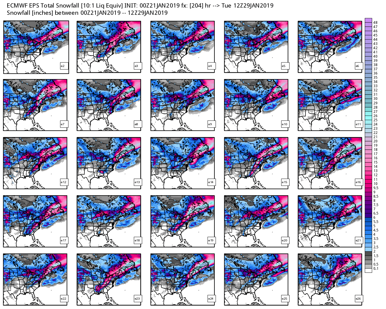
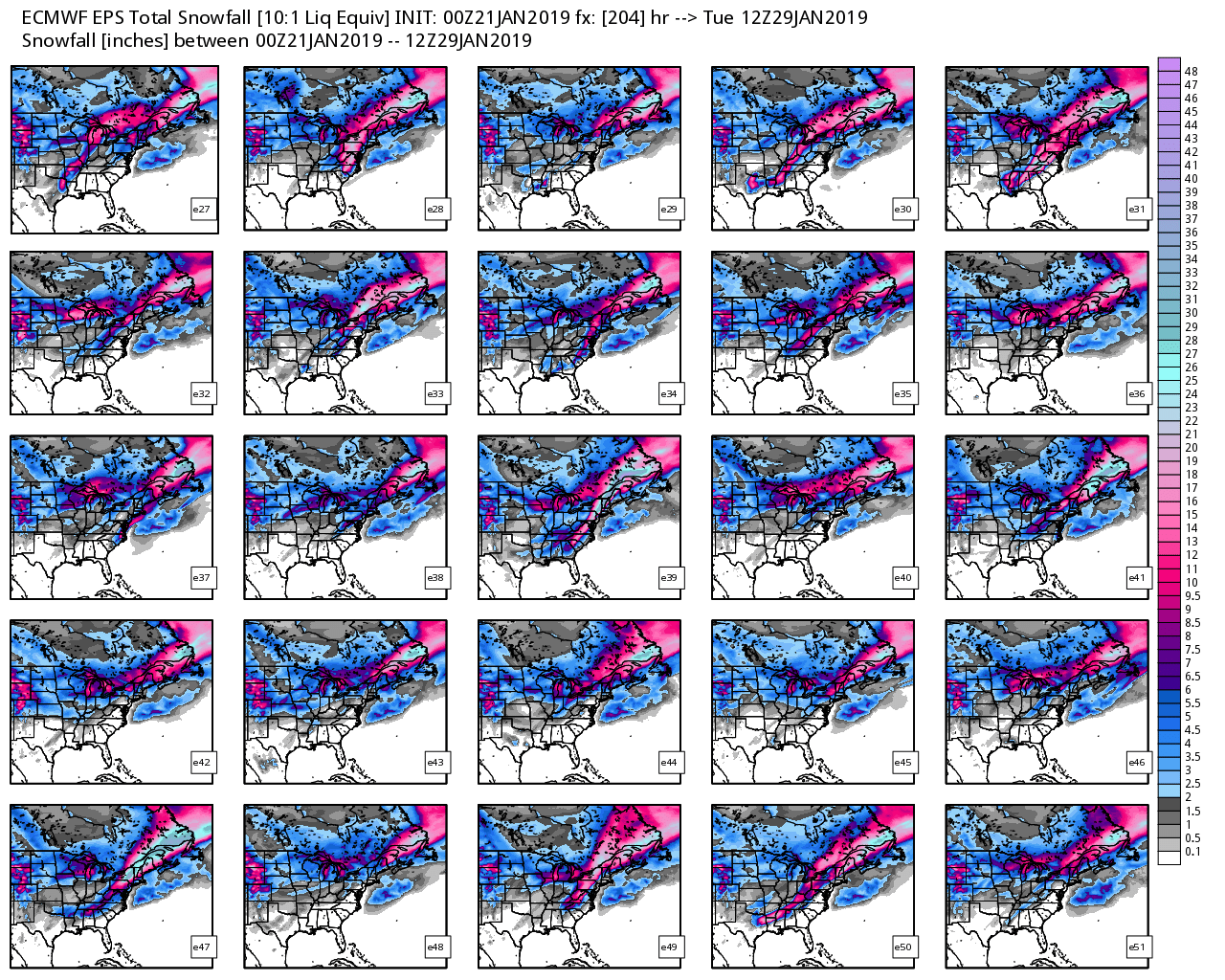
Mid to Long Term Discussion 2019
nchighcountrywx replied to Upstate Tiger's topic in Southeastern States
March 1980 https://www.weather.gov/mhx/Mar011980EventReview Up to 30” eastern NC and snowed in the teens -
Mid to Long Term Discussion 2019
nchighcountrywx replied to Upstate Tiger's topic in Southeastern States
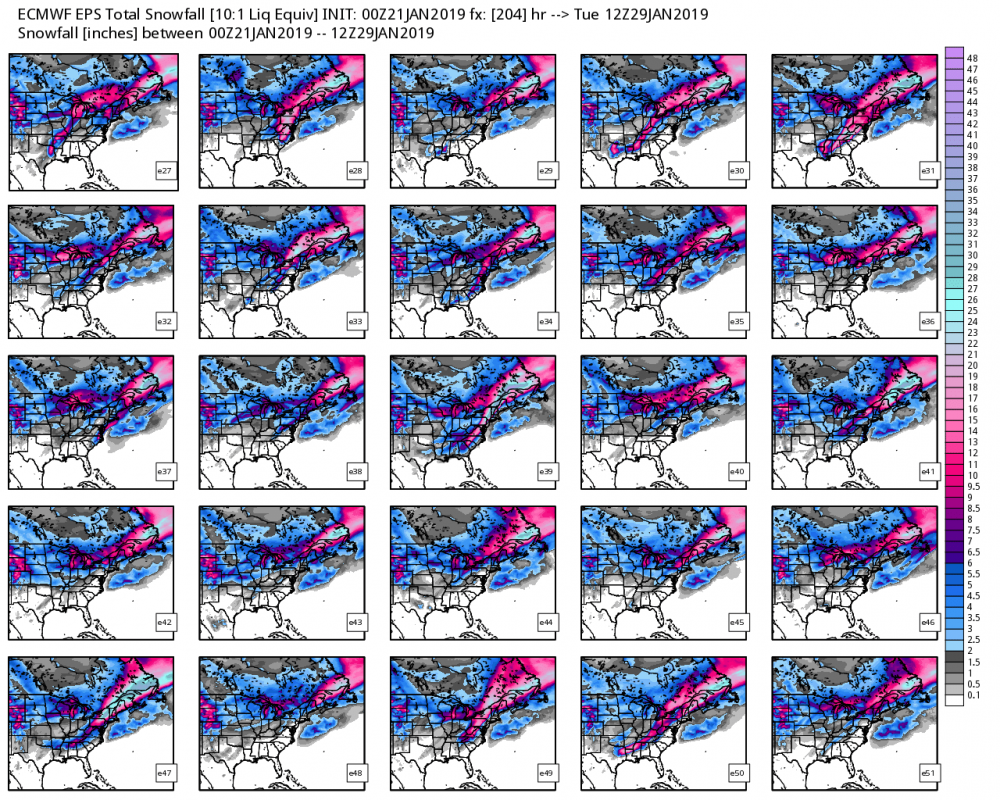
New Euro Week 3 Michael Ventrice (@MJVentrice) 1/28/19, 17:44 Verification pic.twitter.com/RXduMxnd1V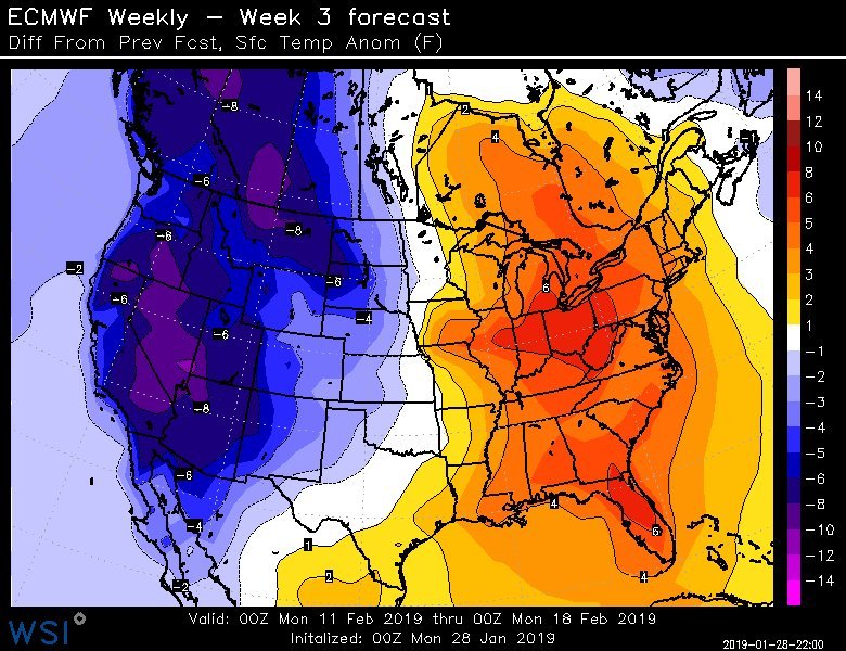
-
Mid to Long Term Discussion 2019
nchighcountrywx replied to Upstate Tiger's topic in Southeastern States
JB thinks the models have it wrong in 2 weeks and the blocking ridge will be where he has it circled around February 11 which will keep a cold push and active storm track through the South. Let’s hope it works out -
Mid to Long Term Discussion 2019
nchighcountrywx replied to Upstate Tiger's topic in Southeastern States
If you are outside of the High Country, I think you have to hang in there and hope for something after the 15th -
Mid to Long Term Discussion 2019
nchighcountrywx replied to Upstate Tiger's topic in Southeastern States
And Euro... -
Mid to Long Term Discussion 2019
nchighcountrywx replied to Upstate Tiger's topic in Southeastern States
GFS -
Mid to Long Term Discussion 2019
nchighcountrywx replied to Upstate Tiger's topic in Southeastern States
And this on the way from Pacific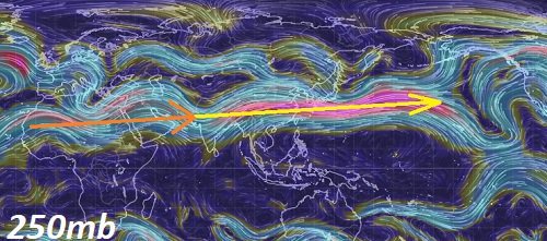
-
Mid to Long Term Discussion 2019
nchighcountrywx replied to Upstate Tiger's topic in Southeastern States
Sharp gradient Wednesday night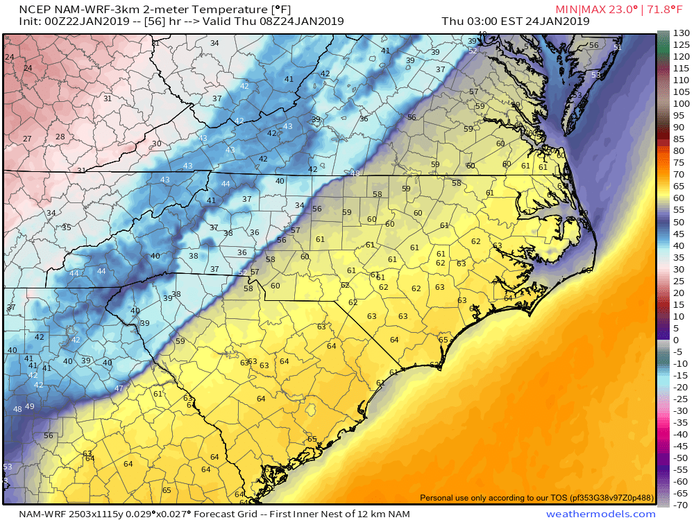
-
Mid to Long Term Discussion 2019
nchighcountrywx replied to Upstate Tiger's topic in Southeastern States
Noted: Joe Bastardi (@BigJoeBastardi) 1/21/19, 09:13 Euro Ensembles lining up grand planetary wave feature N Pole to 20 north similar to 1993 superstorm pattern, For an ensemble run given its many members pretty darn impressive below Day 8, 6-10 mean 500, day 7,8 surface Pattern is not boring, no one is snoring pic.twitter.com/xPzxN3uHFC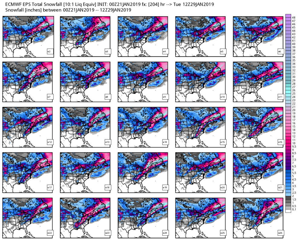
-
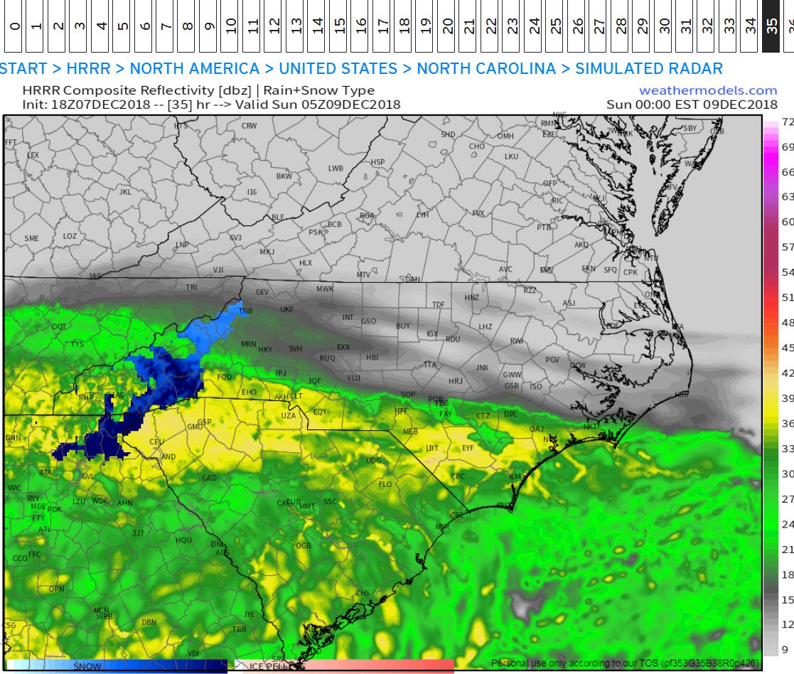
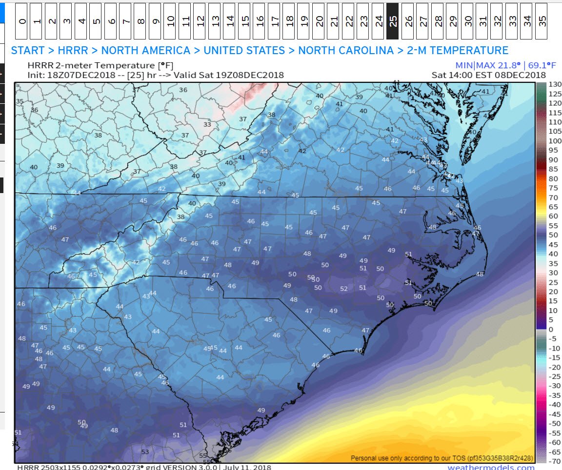
December 8-10, 2018 Winter Storm
nchighcountrywx replied to Orangeburgwx's topic in Southeastern States
NAM output courtesy of Wright Weather Snow Sleet Freezing Rain -
December 8-10, 2018 Winter Storm
nchighcountrywx replied to Orangeburgwx's topic in Southeastern States
HRRR for Sunday 4am -
December 8-10, 2018 Winter Storm
nchighcountrywx replied to Orangeburgwx's topic in Southeastern States
Updated WPC Guidance and Discussion https://www.wpc.ncep.noaa.gov/discussions/hpcdiscussions.php?disc=qpfhsd -
December 8-10, 2018 Winter Storm
nchighcountrywx replied to Orangeburgwx's topic in Southeastern States
1AM Sunday -
December 8-10, 2018 Winter Storm
nchighcountrywx replied to Orangeburgwx's topic in Southeastern States
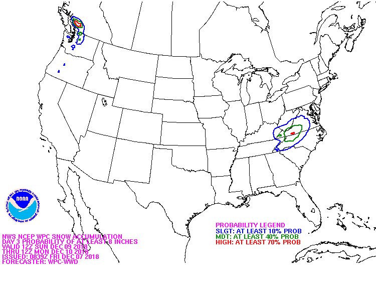
New WPC Probabilities -
December 8-10, 2018 Winter Storm
nchighcountrywx replied to Orangeburgwx's topic in Southeastern States
And the Sunday 0Z HRRR Simulated Radar
-
December 8-10, 2018 Winter Storm
nchighcountrywx replied to Orangeburgwx's topic in Southeastern States
I think someone else posted it, but this is what the HRRR does to temperatures mid afternoon Saturday Reason for concern: Yes
-
December 8-10, 2018 Winter Storm
nchighcountrywx replied to Orangeburgwx's topic in Southeastern States
WPC Maps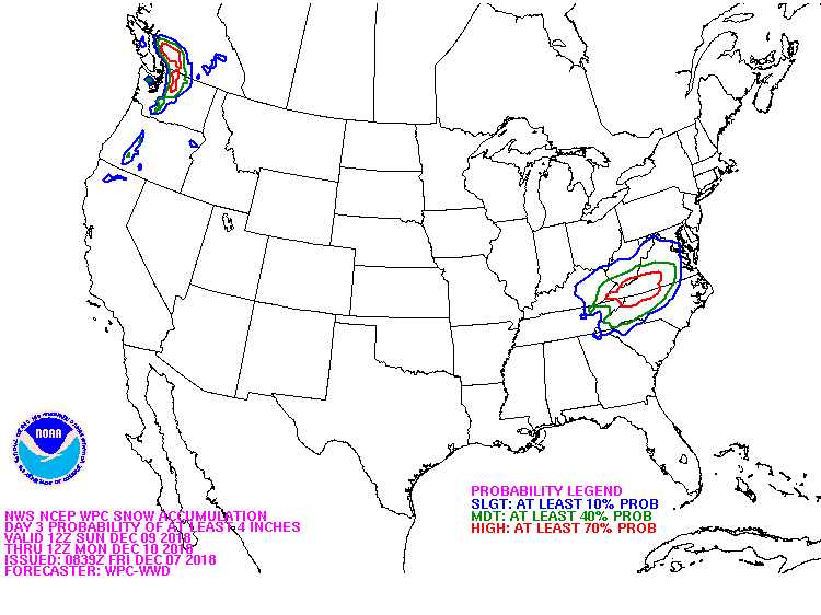
-
December 8-10, 2018 Winter Storm
nchighcountrywx replied to Orangeburgwx's topic in Southeastern States
WPC Heavy Snowfall Discussion https://www.wpc.ncep.noaa.gov/discussions/hpcdiscussions.php?disc=qpfhsd -
December 8-10, 2018 Winter Storm
nchighcountrywx replied to Orangeburgwx's topic in Southeastern States
Mike Dross (@MikeWDross) 12/6/18, 14:52 @AlConklin Yep. It gets started /w deterministic snowfall maps from GFS/ECMWF that are flawed to begin with, not to mention 5+ days out. By the time we get into the mesoscale model time frame (when we actually know what's likely), public already going off flawed/inferior/old model data. +100