nchighcountrywx
-
Posts
2,644 -
Joined
-
Last visited
Content Type
Profiles
Blogs
Forums
American Weather
Media Demo
Store
Gallery
Everything posted by nchighcountrywx
-
2020 Spring and Summer mountain thread.
nchighcountrywx replied to Met1985's topic in Southeastern States
Classic feature 30’ film on The NC High Country and entire state https://youtu.be/lEro9Z0Edy0 -
2019/2020 Mountains and Foothills Fall/Winter Thread.
nchighcountrywx replied to Tyler Penland's topic in Southeastern States
Some snow inbound over 4500’ https://imgur.com/gallery/Bmiws6b -
2019/2020 Mountains and Foothills Fall/Winter Thread.
nchighcountrywx replied to Tyler Penland's topic in Southeastern States
Looks good for more high elevation accumulating snow later Friday and overnight
-
2019/2020 Mountains and Foothills Fall/Winter Thread.
nchighcountrywx replied to Tyler Penland's topic in Southeastern States
Appalachian Trail Over Hump, Big Yellow and Roan Mountains Balds in December 2019 Absolutely fantastic 1 hour video and rendering of the experience of being in the AT with snow cover and above the clouds. Few are blessed to experience this in summer and even fewer in winter. It is truly the best the NC High Country has to offer. Heaven at its best. Kudos to the fellow who put this together Enjoy -
Mid to Long Term Discussion 2019
nchighcountrywx replied to Upstate Tiger's topic in Southeastern States
-
2019/2020 Mountains and Foothills Fall/Winter Thread.
nchighcountrywx replied to Tyler Penland's topic in Southeastern States
Warnings hoisted Avery-Madison-Yancey-Mitchell-Haywood-Graham- Including the cities of Ingalls, Banner Elk, Newland, Faust, Mars Hill, Marshall, Walnut, Allenstand, Hot Springs, Luck, Swiss, Burnsville, Celo, Micaville, Ramseytown, Busick, Spruce Pine, Poplar, Waynesville, Waterville, Canton, Cruso, Cove Creek, Robbinsville, and Stecoah 257 PM EST Sun Dec 1 2019 ...WINTER STORM WARNING IN EFFECT FROM 7 PM THIS EVENING TO 7 AM EST TUESDAY ABOVE 3500 FEET... ...WINTER WEATHER ADVISORY REMAINS IN EFFECT FROM 7 PM THIS EVENING TO 7 AM EST TUESDAY BELOW 3500 FEET... * WHAT...For the Winter Storm Warning, heavy snow expected. Total snow accumulations of up to 11 inches above 3500 feet. Winds gusting as high as 50 mph. For the Winter Weather Advisory, snow expected. Total snow accumulations of up to 5 inches in these lower elevations. Winds gusting as high as 45 mph. * WHERE...The mountains of western North Carolina, generally near the Tennessee border. * WHEN...From 7 PM this evening to 7 AM EST Tuesday. * IMPACTS...Travel could be very difficult to impossible. The hazardous conditions could impact the morning or evening commute. Gusty winds could bring down tree branches -
Our friend and board contributor Big Frosty from the Foothills of NC is having back spinal surgery this morning to have spacers and a rod put in to help lessen back pain associated with nerve compression. Please cover him in prayer this morning for a successful surgery with no complications.
-
Looking Ahead to Fall and Winter
nchighcountrywx replied to Iceagewhereartthou's topic in Southeastern States
BAM Official 2019-2020 Winter Forecast Jon Miller is joined by Michael Clark of BAMWx.com to discuss BAM's Official Winter of 2019-2020 Forecast. Clark believes the United States could be in for a Top Eight to Top Twelve coldest winter. The key a anomalous Pacific SST during a rate El Nino Modoki Pattern 2014/2015 1977/1978 -
2019/2020 Mountains and Foothills Fall/Winter Thread.
nchighcountrywx replied to Tyler Penland's topic in Southeastern States
BAM Official 2019-2020 Winter Forecast Jon Miller is joined by Michael Clark of BAMWx.com to discuss BAM's Official Winter of 2019-2020 Forecast. Clark believes the United States could be in for a Top Eight to Top Twelve coldest winter. The key a anomalous Pacific SST during a rate El Nino Modoki Pattern and the QBO 2014/2015 1977/1978 -
Weather Flow Winyah Bay Subscription needed for Pro Stations https://imgur.com/gallery/kbvzvfx
-
Bastardi comments specific to Wilmington Area Joe Bastardi just said prepare for wind gusts at least 75 to 100 along NC Coast with 120 to 140 possible in places. Similar to Hurricane Helene in 1958 for Wilmington relative to impacts.
-
Looking Ahead to Fall and Winter
nchighcountrywx replied to Iceagewhereartthou's topic in Southeastern States
WeatherBell Joe D’Aleo posting on fall and winter is out this morning -
2019 Mountains and Foothills Spring/Summer thread
nchighcountrywx replied to FlatLander48's topic in Southeastern States
49 over 43 at Mitchell. Mitchell may go down to 42 ! -
2019 Mountains and Foothills Spring/Summer thread
nchighcountrywx replied to FlatLander48's topic in Southeastern States
Our own local Baker Perry from ASU was a key part in this. Congrats Baker! An ultimate accomplishment! https://www.nationalgeographic.com/adventure/2019/06/mount-everest-highest-weather-station/?fbclid=IwAR01v4bw89wD8sPm-EaS6gdP6d9Q8IhLoxZj1c3ZrCkxtmCq8qn7lbcfbHQ To design and install a series of automated weather stations at various altitudes, Mayewski recruited Baker Perry, a tall, taciturn climate scientist from Appalachian State University, who once played professional basketball in Bolivia, and Tom Mathews, a quick-talking English climatologist and avid marathoner from Loughborough University. Here is a link to the data: https://nationalgeographic.org/earth-pulse/everest/widget/16?embed=true -
At first look it is warmer than the ECMWF for early next week
-
Solar minimum is here : https://www.express.co.uk/news/science/1136531/Solar-minimum-NASA-Sun-temperatures-sunspots-solar-flare-activity-Maunder-Minimum https://spaceweatherarchive.com/2019/04/10/experts-predict-the-solar-cycle/ https://www.express.co.uk/news/science/1135628/weather-forecast-long-range-climate-change-space-weather-solar-minimum-space-news
-
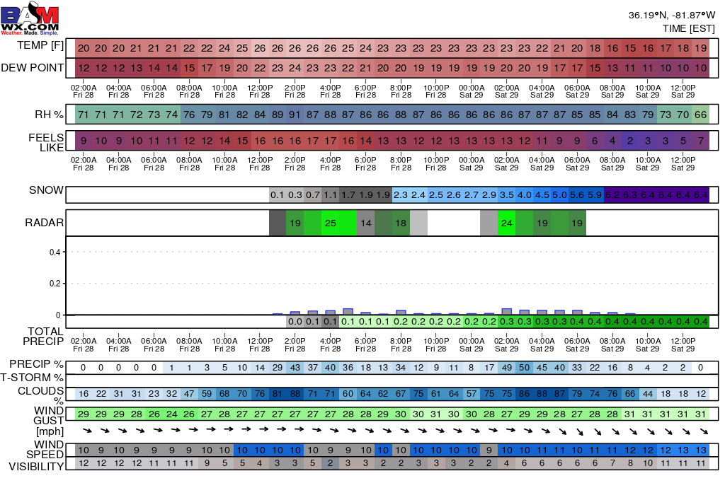
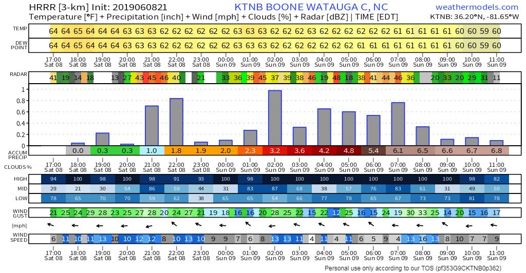
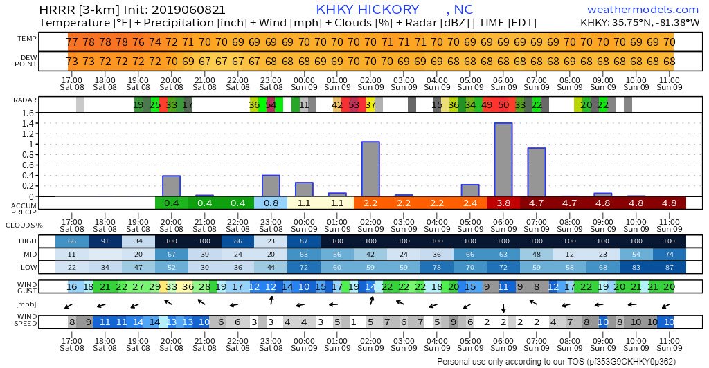
2019 Mountains and Foothills Spring/Summer thread
nchighcountrywx replied to FlatLander48's topic in Southeastern States
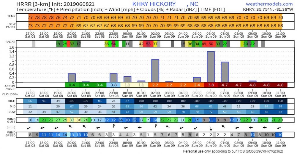
Here are the historic HRRR Runs for both Boone and Hickory during the Saturday night flooding
-
2019 Mountains and Foothills Spring/Summer thread
nchighcountrywx replied to FlatLander48's topic in Southeastern States
Good video from Cowans Ford Dam at southern end of Lake Norman at Catawba Springs that someone posted https://m.facebook.com/scott.dubois.56679/posts/pcb.1276374619207087/?photo_id=137802397323477&mds=%2Fphotos%2Fviewer%2F%3Fphotoset_token%3Dpcb.1276374619207087%26photo%3D137802397323477%26profileid%3D100028049062478%26source%3D48%26refid%3D18%26_ft_%3Dqid.6700708148741099547%3Amf_story_key.1276374619207087%3Agroup_id.515274225317134%3Atop_level_post_id.1276374619207087%3Atl_objid.1276374619207087%3Acontent_owner_id_new.100032811523330%3Asrc.22%3Aphoto_attachments_list.[137802397323477%2C137802407323476%2C137802463990137%2C137802433990140%2C137802443990139]%3Astory_location.6%3Astory_attachment_style.album%26__tn__%3DEH-R%26cached_data%3Dfalse%26ftid%3D&mdp=1&mdf=1 -
2019 Mountains and Foothills Spring/Summer thread
nchighcountrywx replied to FlatLander48's topic in Southeastern States
Johns River -
2019 Mountains and Foothills Spring/Summer thread
nchighcountrywx replied to FlatLander48's topic in Southeastern States
Courtesy of Chris Armstrong. Chris is working on editing his video from 3 Catawba Valley Basin dams this morning Here is the Oxford Dam spillway between Lake Hickory and Lookout Shoals -
2019 Mountains and Foothills Spring/Summer thread
nchighcountrywx replied to FlatLander48's topic in Southeastern States
On my twitter feed @nchighcountrywx -
2019 Mountains and Foothills Spring/Summer thread
nchighcountrywx replied to FlatLander48's topic in Southeastern States
Headwaters of Lake Norman at Lookout Shoals Dam is highest it has been since 1940. Areas of northwest Catawba County, eastern Caldwell County, and western Alexander County saw 8-12 inches of rainfall. The heaviest rainfall was focused over the watersheds feeding Lake Rhodhiss and Lake Hickory and was responsible for levels at Lookout Shoals Lake not seen since 1940. This has caused flooding of homes along the lake and evacuation orders are in effect. * The latest lake level data for Lookout Shoals Lake are as follows: CURRENT POOL...106.7 feet (Moderate Flooding) and falling steadily. FULL POOL...100.0 feet. CREST...108.19 feet at 9am on June 9. This is the highest level recorded since August 1940, when the lake crested at 114.40 feet. Crests during the 2004 and 2013 floods were 107.4 and 107.0 feet, respectively. Video will not post so still image -
I could see Friday that Hickory area would likely get the worst of it and unfortunately the models were spot on. Which watershed runs through your area? It is painful to see individuals and board members impacted by flooding.
-
2 day daily CoCoRaHS observations
-
2019 Mountains and Foothills Spring/Summer thread
nchighcountrywx replied to FlatLander48's topic in Southeastern States
https://origin.wpc.ncep.noaa.gov/metwatch/metwatch_mpd_multi.php?md=0398&yr=2019