

SnowGoose69
-
Posts
16,188 -
Joined
-
Last visited
Content Type
Profiles
Blogs
Forums
American Weather
Media Demo
Store
Gallery
Posts posted by SnowGoose69
-
-
1 minute ago, mob1 said:
By 1.7 miles.
The storm is in 48 hours, that shift means nothing. It's more about whether it's right in the first place, but recents trends have been worrying.
It caved to everything else on the other storm so I am not sure I am too confident about what its doing. It probably ends up close to a GFS/ICON idea in the end which is middle between Euro/RGEM
-
 1
1
-
-
God those are ballsy watch areas I have to say. If the EPS is even 50% right most of those are going to end up being dropped entirely.
-
 1
1
-
-
3 minutes ago, EWR757 said:
As an example, the 12Z AIFS has EWR above freezing boundary layer until about 00Z on Monday. The GFS is similar.

Makes no sense though based on GFS track, GFS has N'ly winds and a T/Td at EWR of 32/24 when snow moves in, would probably be down to 29 degrees pretty fast and never move from there
-
Rare case where the #1 CIPS analog is a pretty darn close case...overall everyone from NYC to BOS was 2-5, there was definitely less of a surface reflection in this case though than this time
https://www.meteo.psu.edu/ewall/NARR/1984/us0119.php
-
1
-
-
Most of the CIPS analogs were light events, only one that is terribly close at 500 is 1/18-19/84 which was around 3-4 most of the area. Many were inland snow events, but way inland because the whole trof axis in the east was much further west than it is here.
https://www.meteo.psu.edu/ewall/NARR/1984/us0119.php
-
1
-
-
The NAM totally sucked last week too with the storm in the south, not sure why its suddenly having such major issues, been awhile since I've seen it do this
-
2
-
-
We are still far out buy the Euro still tends to be too low on QPF in my mind on any system that’s entraining Atlantic or Gulf moisture. It was the only model to accurately depict the snow in the MA two weeks ago because that was a rare case of a W-E moving storm where you weren’t entraining a ton of Atlantic moisture into it.
-
Just now, Allsnow said:
Side note
18z euro gives New Orleans 4-5 inches
yeah to me that event is close to dead as far as coming up the coast. I’ve been hitting the 73-89 drum on that for 3 days. Canadian may have nailed this one up here but it’s gonna bomb I think on its idea down there
-
1
-
 1
1
-
-
I think it’s getting late early for places in northern MS/AL. Not necessarily the same in GA/SC. I think ATL/GSP may still be alive albeit barely. This has potential to have a late movement up the coast still where those areas may get hit though I still think I’d rather be in Augusta or Columbia
-
2
-
1
-
-
I still cannot believe how different the GFS is in the SE past 120 compared to every other model
-
5
-
-
3 minutes ago, Heisy said:
Difference between GFS, CMC, and Euro AI at 90 hours
To give you an idea of what differences each model has.
18z rgem was in the euro Ai camp fwiw
.The GFS/GEFS difference for the storm on the Gulf Coast last 120 could be the craziest difference I’ve seen from the Op to an ensemble on a single model run inside day 7 ever
-
3
-
-
6 minutes ago, EWR757 said:
DEN is a weird case. The airport is on a windy plain, it is 6 miles from the SW corner to the NE corner of the airport. I don't know of any houses anywhere near the airport, within miles. Not the best place to measure snow depth.
I’ve wondered with Denver where the person who measures is at since there isn’t exactly anyone nearby as you said
-
1 minute ago, StantonParkHoya said:
GEFS looks wetter than 12z.. hmmm
Yeah it’s not even close to the Op. that’s extremely rare to see with the GFS honestly. They usually are in tandem but there are some setups where there can be wild differences from the Op to the ensembles
-
1
-
-
18 minutes ago, snowman19 said:
I can’t remember the last time the GFS actually scored a coup inside of 4 days but boy is it insistent on Sunday being a complete non event run after run
It also has no event in the south after that so it’s most likely wrong
-
1
-
-
41 minutes ago, NorthShoreWx said:
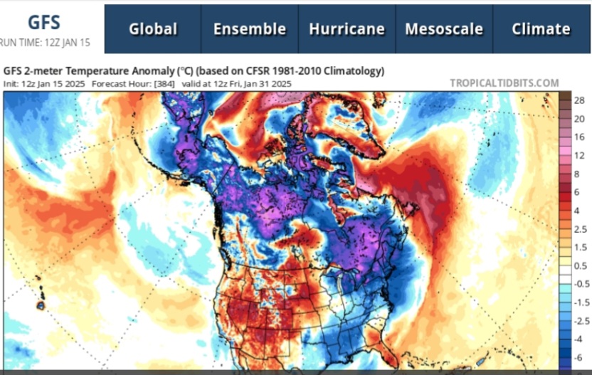
The 12z GFS remains quite cold through the end of the run. One thing that I find interesting is that the surface temperature maps imply that the remaining open water in the eastern and northeastern parts of Hudson Bay will remain unfrozen for the next 384 hours. That seems unlikely since the open waters are shallower than much larger frozen area to their west and the surrounding temperatures are forecasted (in this run of the GFS) to be below normal much of the time beginning this weekend. I imagine the temperatures in that area are overdone late in the model run.
No matter how many times that SE ridge keeps trying to appear beyond about 290 hours it keeps getting flattened or pushed east once we get closer in time
-
3
-
-
7 minutes ago, NC_hailstorm said:
Artificial Intelligence Forecasting System,or known as Euro AI or (Big AL) is cooking today.

As good as the AI has been its been jumpy post 120. It keeps going more with the GFS idea of the later wave and the system digging for China. I am not sure I buy that. I think something between the UKMET/ICON where it ejects along the Gulf from TX vs coming up out of the oil rigs is more likely.
-
2
-
-
Just now, The 4 Seasons said:
Ok, great thanks for the info i really appreciate it. I didn't know BOS wasnt measured at the airport. Where exactly is it measured and by whom?
I think all 4 are someone who lives just off the airport within 1 mile. BOS you'll notice never puts 4 groups or SNINCR remarks in METARs during snow events as those other airports do not either. If you see that you know they are not measuring there.
-
1
-
 1
1
-
-
Just now, The 4 Seasons said:
is that 12Z? Where do you get it so fast, TT and Wxbell isnt out yet.
I also have a question for anyone here, for plotting snowfall. Is snowfall measured at ISP airport itself or is it Brookhaven (upton) doing the measuring and its kept record at the airport as "Islip Area"?
No it was the 06. I believe ISP measures at the airport. As far as I know the only airports nationwide where the measuring is not done at the field are BOS/PHL/DTW/DEN. There may be others I am not aware of but those all got moved due to bad measuring and JFK was close to being moved too
-
1
-
1
-
-
Hope the EURO AI is right. No QPF available but probably is like 2-5 inches. Its been so good the last month or two inside of 120. A bit erratic beyond that and I feel the Euro/EPS has beaten it from 120-180 but it was really the only model that accurately depicted the SRN US Event last week from days out
-
4
-
-
I still like the idea right now of places like BHM/ATL being on the north end of this and it being more a central AL-GA-coastal SC NC event. But I am still wary of the fact that these days these cold air masses tend to be overdone on models at this range, if thats the case again something near or just south of this previous event is likely.
-
2
-
 1
1
-
-
CMC and ICON following the Eric Webb theory, he said he felt the boundary was gonna be slower to press east than modeled and hence we'd see a more bomby type low though he said risk the coast could be rainy if it was too slow
-
8 minutes ago, Stormlover74 said:
It's the icon
The ICON honestly from D5-8 the last month has been better than the GFS. This may be a bit crazy for the moment though
-
2
-
-
18Z Op Euro was gonna look nothing like the 18Z GFS if it ran past 144, thats for sure
-
3
-
-
40 minutes ago, snowman19 said:
19-20 looks real for a light event. As for the 23rd you are correct, that op EURO run has virtually no EPS support
I think that event is another southern event. The SE forum was worried about the FZRA and it moving NW I said there's a better chance that event goes December 89 than trends NW but its still far enough out and the first event impacts that one. Depending how it evolves it might sharpen the trof too much in the East which would then prevent the wave from being able to eject from Texas across the Gulf. The trof needs to be more meridional from DFW-ATL or you typically cannot eject the system and it buries.
-
1
-
 1
1
-
As WAR expands, do our snow chances increase? First wave may produce a middling event-solid advisory and possible low end warning for MLK Weekend
in New England
Posted
I'd give the RGEM no credit given the CMC's now no longer awesome performance on the 2nd storm but the ICON moving W gives me some belief maybe the RGEM gets weighted more than the Euro in the split difference in the end