Allsnow
-
Posts
26,403 -
Joined
-
Last visited
Content Type
Profiles
Blogs
Forums
American Weather
Media Demo
Store
Gallery
Everything posted by Allsnow
-

December 2020 General Discussions & Observations Thread
Allsnow replied to bluewave's topic in New York City Metro
Didn’t say it would dominate the second half of December? -
December 2020 General Discussions & Observations Thread
Allsnow replied to bluewave's topic in New York City Metro
If we don’t improve the pac all we will be blocking is mild air. The Ao is negative but spilling the cold on the other side of the globe. The -nao is probably a result of the weakening Pv. We have a chance at something working out but my money is on us waiting for January. The mjo wave currently looks to make it into p7 (even if weakly) should improve the pac -
December 2020 General Discussions & Observations Thread
Allsnow replied to bluewave's topic in New York City Metro
Southeast ridge is non existent which is not normal for Niña -
December 2020 General Discussions & Observations Thread
Allsnow replied to bluewave's topic in New York City Metro
Looks like some p7 at the end of the month could improve the pac. -
December 2020 General Discussions & Observations Thread
Allsnow replied to bluewave's topic in New York City Metro
All 3 ensembles now have textbook Greenland blocking developing -
December 2020 General Discussions & Observations Thread
Allsnow replied to bluewave's topic in New York City Metro
Any pattern works for New England lol -
December 2020 General Discussions & Observations Thread
Allsnow replied to bluewave's topic in New York City Metro
This. We have a better chance of getting lucky instead of no chance -
December 2020 General Discussions & Observations Thread
Allsnow replied to bluewave's topic in New York City Metro
I see nobody hyping it in here. If anything, you said a -nao wasn’t coming -
December 2020 General Discussions & Observations Thread
Allsnow replied to bluewave's topic in New York City Metro
Great question! I will take a good pacific over anything else. We would drool over a -ao/-nao/+pna pattern -
December 2020 General Discussions & Observations Thread
Allsnow replied to bluewave's topic in New York City Metro
-
December 2020 General Discussions & Observations Thread
Allsnow replied to bluewave's topic in New York City Metro
-
December 2020 General Discussions & Observations Thread
Allsnow replied to bluewave's topic in New York City Metro
The TPV is moving into Canada. It will get cold. That’s a positive for us moving forward -
December 2020 General Discussions & Observations Thread
Allsnow replied to bluewave's topic in New York City Metro
-nao/-ao and we cant get cold lol -
December 2020 General Discussions & Observations Thread
Allsnow replied to bluewave's topic in New York City Metro
Looks negative going forward into December. Just nothing to get it down here with a +epo -pna -
December 2020 General Discussions & Observations Thread
Allsnow replied to bluewave's topic in New York City Metro
What a waste of a -A0. We finally get it but no way to get the cold down here -
December 2020 General Discussions & Observations Thread
Allsnow replied to bluewave's topic in New York City Metro
No -
December 2020 General Discussions & Observations Thread
Allsnow replied to bluewave's topic in New York City Metro
-
December 2020 General Discussions & Observations Thread
Allsnow replied to bluewave's topic in New York City Metro
This is a absolutely ridiculous post...did you mean to post this? -
December 2020 General Discussions & Observations Thread
Allsnow replied to bluewave's topic in New York City Metro
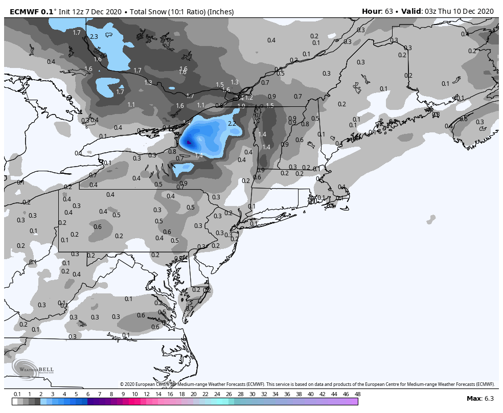
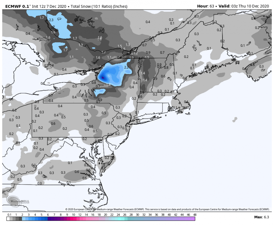
Light snow for nyc Wednesday morning.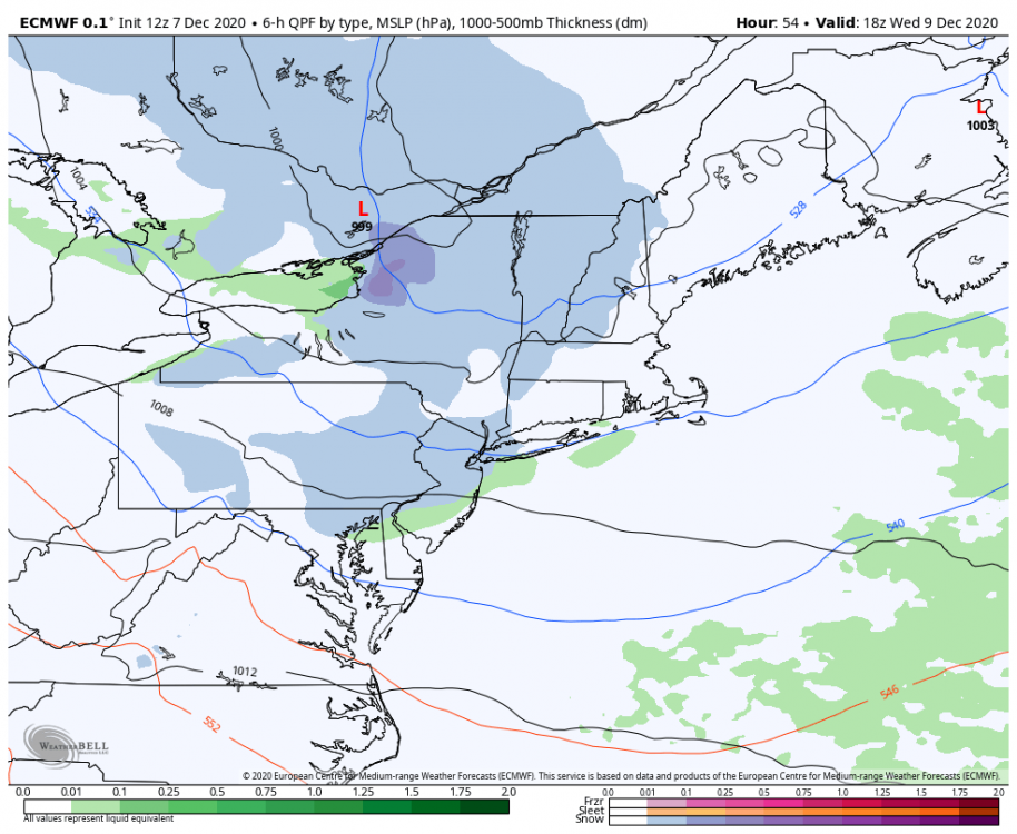
-
December 2020 General Discussions & Observations Thread
Allsnow replied to bluewave's topic in New York City Metro
That’s a accurate chart of what’s going on currently. As of now no secondary peak is imminent. The eastern pac has actually warmed over the last few weeks. -
December 2020 General Discussions & Observations Thread
Allsnow replied to bluewave's topic in New York City Metro
-
December 2020 General Discussions & Observations Thread
Allsnow replied to bluewave's topic in New York City Metro
This isn’t going to be last winter where the PV gained strength and the mjo went wild at the end of December. The vortex is going to stay in Canada which will keep them cold. All we would need is something to buckle the flow to get the cold here. This December is acting more like a niño then Niña. Perhaps we get a niño January/February instead then. Who knows -
December 2020 General Discussions & Observations Thread
Allsnow replied to bluewave's topic in New York City Metro
Not according to the this. We peaked in October and will be moderate for the winter.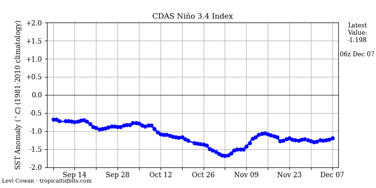
-
December 2020 General Discussions & Observations Thread
Allsnow replied to bluewave's topic in New York City Metro
Which was forecasted I believe from early last week. It was never supposed to be super below normal. The warmth was expected by the weekend. I believe I even posted about it. The following week won’t be cold because we lost the -epo look -
December 2020 General Discussions & Observations Thread
Allsnow replied to bluewave's topic in New York City Metro
I didn’t really say anything about cold in my post lol. I agree, lately it has been the theme. But I do think the models did a good job calling for this week to be cold. Its just going to be dry so no snow means nobody will care.