

Allsnow
-
Posts
24,135 -
Joined
-
Last visited
Content Type
Profiles
Blogs
Forums
American Weather
Media Demo
Store
Gallery
Posts posted by Allsnow
-
-
-
-
18z eps snow mean.

-
 2
2
-
-
30 minutes ago, Rjay said:
0z runs coming up
The last minute trends this winter have been ridiculous


-
3
-
 1
1
-
-
Snowfall this morning.
Knyc 0.2
Lga 0.7
Jfk 0.3
Ewr 0.9
-
2
-
-
21 minutes ago, snowman19 said:
Assuming it finally does actually propagate and goes 8-1 in early February, the change probably would not be felt here until mid-February with the lag correct? I’m thinking the colder period is something like 2/15 - 3/15
There can be a lag but it’s not 100% of the time. You won’t get high amplitude in the cold phases as it doesn’t work that way. But your colder period could very well be correct. It’s really all a guess at this point lol
-
21 minutes ago, Isotherm said:
Yes, verbatim, those projections would indicate forcing reaching phase 8 (though at a much lower amplitude) by Feb 3rd. Those plots were also derived from Roundy's website.
Hopefully, we can get a p8 response. I still think we improve the pattern by the end of the month. But as you said it can’t really get much worst then this weekend lol. Even in p7 we wouldn’t be bias warm, I would think it would be more ups and downs between warm/cold.
-
1
-
-
2 minutes ago, Isotherm said:
Looks like on those maps the mjo is on the border of 6/7 on the 29th (which might indicate it slows down in p6) then by feb 3 P8-1? And forcing in the western pac? If I’m correct, then that matches the Vp maps well. I also like the substance forming in the warm phases.
-
Scrape for us but a nice hit for the Mid Atlantic


-
1
-
-
12z euro will be further northwest this run for tomorrow night
-
1
-
-
The roundy plots continue to show the mjo wave getting into p8. I think one of the reasons the GEFS are stuck in the Niña pattern is because of its mjo forecast. It keeps it in 6 which imo is wrong.

GEFS

euro

-
3
-
-
17 hours ago, Allsnow said:
Euro continues to show some snow for the area tonight.

Nice job by the euro! Solid coating of snow here overnight
-
-
9 minutes ago, NYCweatherNOW said:
It’s going to be too dry to precipitate, yes you may get a snow shower but I don’t think this is even worth posting
It’s not going to be too dry
-
-
6 hours ago, CoastalWx said:
Ok well looking ahead, we have Scandi ridging finally developing. It also looks like the PV finally gets stretched and is not concentric anymore. That’s usually a sign things are going on above. Sometimes Scandi ridging helps get that process started.

I read your post to him. Great stuff. Let’s hope the Scandinavian ridge can get the wave 1 hits going.
-
Just now, purduewx80 said:
NYC records are 63 and 66 on the 11th/12th and EWR's are 66 and 67, respectively. I still think fog/stratus could keep temps a bit cooler than what it's showing.
This will probably change, but the ECMWF suggests convection along the front Saturday night may tap into a 65KT+ low level jet. Could be some damage on LI if that verifies.

I agree. Most of the time these warm ups are dirty in January. We are usually not under clear sky’s like December 2015 or January 2007.
-
Next weekend continues to look record breaking with the warmth.


-
1
-
 1
1
-
-
Euro continues to show some snow for the area tonight.
-
2
-
-
52 minutes ago, bluewave said:
We got lucky in March when the strong -EPO disrupted the unfavorable pattern. But there was enough of a lingering influence so the best snows were NYC-LI North Shore, and CT. I only got about 4” here on the South Shore last March.

Yeah, the -epo was the only thing favorable on that map. I got more then half my seasonal snowfall that weekend. Unfortunately, the mid level warmth came in quicker then forecast(as always) for that Sunday night event. It quickly turned the snow to rain on the coast.
-
1
-
-
1 hour ago, Isotherm said:
I think wave-2 activity will increase later this month, but whether it's sufficient to induce a technical SSW is indeterminate. Probability is lower than normal this season, in my view, for one to occur. However, regardless of what happens with the stratosphere, Feb-Mar had/have the highest potential (compared to Dec-Jan) for some improvements in the Atlantic-Arctic domain.
@tombo82685 stated, the wave 2 activity usually is a good indicator for cold shots. It worked very well in 2014.
-
1
-
-
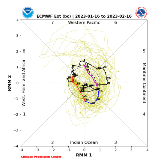
9 minutes ago, bluewave said:
Great post. That background state last February was probably related to the warm pool west of the date line. So even though the RMM charts went though phase 6-1, the actual VP anomalies indicated primary forcing between the phase 6-7 regions.


Yeah, the base state was Niña so we got that response in February. -pna with troughs diving into the west coast.
-
2
-
-
-
31 minutes ago, Isotherm said:
The MJO will certainly be an integral aspect of the entire momentum budget. As I noted pre-season, there were many variables likely to be fundamentally unfavorable for most of the season. Some of those background indicators should improve late-winter [e.g., the QBO]; however, the amelioration in the pattern may only be into a fair/mediocre one [though this would be improved versus the Dec-Jan mean pattern]. Many (not all) of the analogs I examined pre-season would tend to indicate a MJO circuit through 5-6-7, with diminution in 7+ beyond. As an aside, sometimes the background state overwhelms even a favorable MJO circuit. For example, last winter, we did have a 8-1-2 passage late winter, which improved the pattern, but not significantly so. The momentum transports have been unpropitious this winter, and we would need a quite significant vicissitude in that. All said, late winter should *improve* versus Dec-Jan as I've said.

Yeah. The atmosphere was more Niña like and ENSO was Niño during 2019. We really never got a true nino response in that 8-1-2 pass during February. I definitely agree that the mjo wave could go 7-cod at the end of the month. We should improve the pattern to a more of a overrunning look later in the month. As you said in your outlook, the pac isn’t going to play ball this winter. The PDO killed any hope of that.
I still don’t see any strat help in the near future. Do you think it starts taking punches in February? The Scandinavian block developing might be a sign of a -nao coming in February.
-
2
-


January 2020 Discussion
in New England
Posted
4.5 here so far and none of it has stuck to the pavement. I have thrown out any hope of a good winter as we basically punted a month and half so far. I just hope to get to avg and have a solid 2nd half. Tropical forcing should get into the colder phases by the end of the month and the Pv should start taking some hits.
Obviously is sne you guys have more room for error being further north.