-
Posts
24,135 -
Joined
-
Last visited
Content Type
Profiles
Blogs
Forums
American Weather
Media Demo
Store
Gallery
Posts posted by Allsnow
-
-
6 minutes ago, Allsnow said:
12z gfs really blowing up the cutter for Thursday in New England. This should really help with confluence for Saturday.
This is definitely going to be a colder run then 06z. The storm blowing up beforehand help keeps the artic high in place.
-
 1
1
-
-
12z gfs really blowing up the cutter for Thursday in New England. This should really help with confluence for Saturday.
-
9 minutes ago, NYCweatherNOW said:
How was the 6z eps on the low placement for Saturdays event bud?
Pretty far north. The front end is still there but the eps makes it more of a Saturday night event.
-
 2
2
-
-
Some really nice trends with this over night. Last week I mentioned a possible overrunning threat around this timeframe. I can just see ch 7 news now, with the screen shot of last Saturday in the 70’s at Central Park compared to next Saturday in the snow lol.
-
 2
2
-
 1
1
-
-
2 minutes ago, NEG NAO said:
so now you are saying the short range MJO analyses is incorrect along with the long range beyond day 10 ??????
No that’s not what he is saying. When you’re between phases you can still have effects of the previous phase. You can have a bit of lag
-
11 minutes ago, weatherpruf said:
Still rain for 2/3rd of us if I am reading correctly
Next weekend is going to cut into the lakes. If we can get a cold high pressure with some cad perhaps it starts as some snow. I would keep expectations in check with that one. The better patterns starts after next weekend
-
 2
2
-
-
2 minutes ago, bluewave said:
While you hope we get a favorable storm track for heavy snows at the coast, just pointing out a colder pattern coming around the 20th isn’t a guarantee. That’s why storm tracks are so important. Late last January with a similar 500 mb pattern we only got some light snows.
Yep. We very well could swing and Miss. let’s hope for better luck this time. Last January we missed a storm to our south that crushed DCA.
-
 2
2
-
-
-
-
13 minutes ago, NEG NAO said:
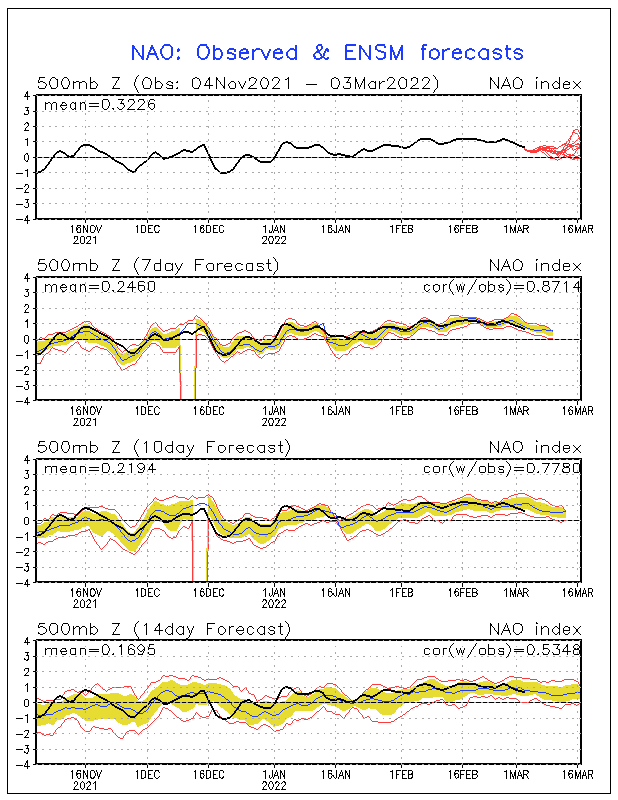
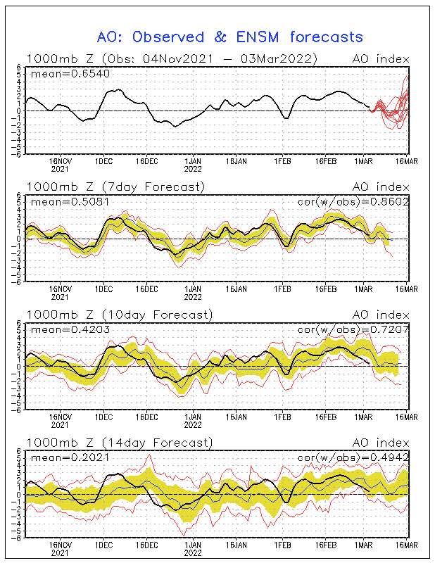
Time will tell - now you have committed to 7-8-1-2 - lets see how long it takes to find a reliable plot that shows that - lets see how long it takes for the models to come around and start showing a more suppressed storm track in the medium range after day 5 - NAO is still showing no signs of going negative anytime soon -same with the AO
I have provided proof with the roundy plots which you fail to acknowledge. I also have the ensembles all agreeing on a pattern change. Those plots you posted are off the GEFS and only going out to jan 16. So if the pattern is supposed to flip after the 20th what do they prove?
-
 1
1
-
-
12 minutes ago, weatherpruf said:
I'm not expecting much. Strictly anecdotal, but good winters ( well, most would consider this a "good" winter so far, due to mild temps ) in my experience usually show an early signal with a cold, icy or snowy Dec. Likewise, dud winters usually follow snowless or mild Dec. But we can still sneak in a good storm, like Jan 2016. That said, I have been following PB's analysis and I give him great weight, so hope he is right.
All we can say is the pattern looks to improve after the 20th. I get it, you can’t shovel potential! We very could score a nice storm or continue the bad luck. For us to get a storm we need a better pattern so we have that.
-
4 minutes ago, EastonSN+ said:
I highly doubt it just drops into the cod like that. I can however see a muted trip through 8 1 2.
I’m not sure how many time it needs to be said that the rmm plots have a bias for cod at the end. Yet, he continues to rip and read them while they correct in front of him. This will be going 7-8-1-2. Yes, it will probably be muted in the colder phases as it’s not going to have strong amplitude like the warm phases.
Even if that plot was to be correct, it would be bias cold because the mjo wave is closer to the cold phases.
-
 2
2
-
-
25 minutes ago, Snow88 said:
Transient? That would stink.
We don’t need some uber -nao to trigger all the cold dry folks
-
 1
1
-
-
28 minutes ago, frd said:
And, as as Don stated yesterday, that higher amplified state in 7 increases the odds of snowfall in the East towards the end of Jan.
bluewave, any thoughts on the developing NAO domain block we are seeing in the GFS and the Euro ?
Do you believe it will indeed be transient in nature and then giving way to the more pronounced - EPO ?
I know Isotherm thought if we were going to get any significant pv disruptions and a -NAO it would be later in the winter. Wondering the implications for Feb and even March and what happens too with the NAM state.
My thoughts are it will be transient in nature but that’s all we really need to capitalize on something. The Scandinavian ridge is really a nice precursor to a -nao.
-
 1
1
-
 1
1
-
-
34 minutes ago, purduewx80 said:
KNYC up to 65 at 11. Already 2F over the previous record.
I didn’t think we would be this clear a few days ago. It’s really off to the races at this point. Out and about around town It feels like a April day.
-
 1
1
-
-
-
Nice call @Isotherm! Looks like the Pv will start taking shots at the end of the month
-
 2
2
-
 1
1
-
-
-
Torching here under clear sky’s. Pushing 60 already here. Get out and enjoy it!
-
-
-
2 minutes ago, NEG NAO said:
The pattern change is all a result from the mjo. We won’t see help from the nao probably not until February if at all. The Ao will be around neutral at the end of the month. This is all from the +pna and -epo
The eps had some transient blocking at the end of the month.
-
 1
1
-
-
50 minutes ago, larrye said:
So what is the consensus opinion on when the pattern changes and when we have the next real "threat"? I looked at the 00z GFS 850 Temp/Precip and it kinda looks like nothing "coastal" (to my amateur eyes) in the longer term until maybe around 1/23 except inland runners. And I didn't check the upper air patterns at all. Thoughts?
The pattern gets better after the 20th. We have a chance at a snow to rain type event next weekend. After that it looks stormy with cold around. But yes, if you’re looking for a classic snowstorm it will be after the 20th. Incredible agreement right now with all the ensembles on a +pna and -epo look.
-
 3
3
-
-
23 minutes ago, weatherpruf said:
Depends on your location. Few of the storms outside of Jan 2016 were much to talk about in my region, relative to others. Only the last March 2018 storm delivered ( about 9 inches give or take ) and we did have the Easter Monday snow of 3-5 as a consolation prize, but other than that it has been near misses, subsidence, mixing issues, dry air, you name it.
Winners and losers in every storm. We haven’t had it bad in middlesex county since 2009. I’ll gladly take 4-8 over getting skunked completely


Wintry mix potential weekend of Jan 18-19, 2020
in New York City Metro
Posted
Low around Erie helps also. Lots of overrunning snows this run for the area. Only negative it the high splits so we a bit of a southeast wind along the coast