

Allsnow
-
Posts
24,135 -
Joined
-
Last visited
Content Type
Profiles
Blogs
Forums
American Weather
Media Demo
Store
Gallery
Posts posted by Allsnow
-
-
Euro ticks colder and snowier for the metro.

-
 1
1
-
-
32 minutes ago, Isotherm said:
Unlike every other event this season hitherto, this one includes a much better antecedent airmass over the local region. Thus, rather than little to nothing, I think it is possible for NYC to record 1-2" of snow tomorrow. EWR/locations immediately NW of NYC could potentially see 2-3". Southerly winds will take several hours to scour out the dense, low-level cold and low dew points.
Agree. This low level cold is no joke thanks to the 1044 high in place. This is your typical swfe climo. Driscoll bridge will be another good dividing line
-
1
-
-
Just now, Brian5671 said:
completely agree. Seems like nothing wants to work out this year....no help anywhere
And reading the post by @Isotherm any help we get will be pac/strat related come mid February.
-
1
-
-
6 minutes ago, Isotherm said:
Thanks -- and I did, and when I stumbled upon it, was fascinated that we arrived at similar conclusions via disparate pathways. His index essentially asserts the same: that this MJO response will be distorted/non-classical as far as the NHEM impacts, and that is due mostly to the reduced ACWB via the convection/momentum transports.
Thanks, if I had to alter anything versus my initial February depiction, if anything, February might be slightly less favorable than I thought in November.
The mjo the last two years has been incredibly frustrating. All we do well with it is amplitude in the warm phases. And when we do get favorable phases (ex feb 2019 and January 2020) we don’t get the response we are expecting. For some reason the mjo in cold phases during November has worked better lol.
Admittedly, I didn’t see how bad the pv was going to hurt us this winter. Once it continued to strengthen and couple with the atmosphere it was lights out.
-
7 minutes ago, SnoSki14 said:
Doesn't look like it'll enter 8 though. Seems it goes through 7 and dies off in circle or stay in 6/7 at very low amplitudes.
I think it’s picking up on a kelvin wave in p6. This is why the rmm plots are decaying in 7 then heading to 6. Most recently as of today, those plots don’t enter 6 anymore and are staying in cod. I think (this is my opinion) you will make it to p8 to start February then decay in io.
-
1
-
-
14 minutes ago, Isotherm said:
Updated thoughts on the pattern, posted in my winter outlook thread:
Key points included therein: brief recapitulation of winter to date, largely concordant w/ expectations, MJO's distorted response, RNA structure in February, late winter opportunities.
Great stuff. Did you read that tweet about the MVP index? From what I understand if it’s + it will prevent from having a typical p8 mjo response.
I agree that we will most likely not see any help from the ao or nao this year.
-
 1
1
-
-
3 minutes ago, Snow88 said:
Gfs has 2-4 for NYC

-
1
-
-
5 minutes ago, Snow88 said:
Rgem looks good for a few inches even In the city. We need a thump and we will be good.
I think the city and immediate suburbs west of the river are good for 2 inches. I can see ewr getting 3-4
-
1
-
-
2 hours ago, bluewave said:
I think that there is also another wild card. We keep seeing that ridge build over the warm pool around Hawaii. Very tough to get the ridge into Alaska with that feature there. I mentioned the ridge pull back that we normally see in an El Niño February the other day. I just hope that this more Niña-like feature doesn’t interfere.


Yeah if the dateline ridge comes back that would also keep the epo form going -. The weeklies are nine chilling for the start of February so perhaps it is going to score a win. It was the first to see the Niña pattern for early January.
-
1
-
-
I’ll go 1-2 for the metro and 2-4 north and west. Long Island c-1. I think sw ct will do the best as in top end of the 2-4.
-
1
-
-
1 hour ago, psuhoffman said:
I don’t think it will stay there. To me it’s a transient look as the vortex traverses AK as an epo ridge establishes itself. That’s my guess given what the trop pac forcing looks like week 2. It looks ominous simply because it’s at the end and so we can’t “see past it”.
But just because we dont get a dumpster fire pattern doesn’t automatically mean we get a great one either. But I don’t think it’s heading towards a permanent AK vortex pac puke pattern
Before that I don’t share either extreme view. We likely get warm after the cold shot next week as the Hudson Ridge drifts too far south and temporarily links up with the mid latitude ridge. But there are ways the look could reasonably shift and suddenly be better.
If the ocean storm next week were to phase with the NS and pull up into a 50/50. Or another yet unseen vort bombs into that space. The wave break from such pumps the ridge over the top and suddenly we get the colder look of some sporadic runs recently. It’s unlikeky but it’s one rather insignificant change in the longwave pattern that has a drastic effect. Another option is the day 10 storm helps to knock down the ridge to our northeast and sets the table for a threat day 12-15. There are ways to avoid a disaster within the look we are getting. But it will involve some luck. It’s flawed but not no hope.
Great to see you post here. Yeah at the end of the eps the vortex looks to be setting up shop. The weeklies have this weakening and Being replaced with a ridge. It would be best to see this low sit in the Aleutians instead of moving into ak.
I know the euro is looping back to p6 on the rmm plots. I wonder if this is the reason we are seeing such swings in the northern pacific. The AAM spike is also playing a role in pushing the ridge into central Canada.
On the roundy plots you can see a kelvin wave in p6. Imo this is why the euro is looping back into p6. I think as we get closer to the end of January you will see it correct into p8. Looks like by mid February the mjo wave dies in 8 and rots in cod. Perhaps then climo nino will take over. The weeklies do look good to start February and have a -nao look to start March lol.
-
2
-
1
-
-
31 minutes ago, snowman19 said:
An AK vortex would be the kiss of death for February, it doesn’t get any uglier than an AK vortex
Yep. Let’s hope its misplaced and we keep it by the Aleutians. It could be because the euro is looping the mjo back to 6. Which imo is bogus but I honestly don’t know anymore. It is what it is at this point
-
2
-
-
25 minutes ago, forkyfork said:
i see an unfavorable pacific that will load the country with warm air which negates any good storm track
Yep. That’s not a good look in the 11-15 day. The goa low would move into ak. Let’s hope that’s not correct. We have seen the 11-15 day just change.
-
1
-
 1
1
-
-
Ripping pretty good here in this snow shower.
-
1
-
-
30 minutes ago, SnoSki14 said:
If you were so confident you wouldn't be throwing a fit and every plot I've seen takes the MJO into phase 7 and then into the COD.
There's a reason the AO/NAO aren't tanking.
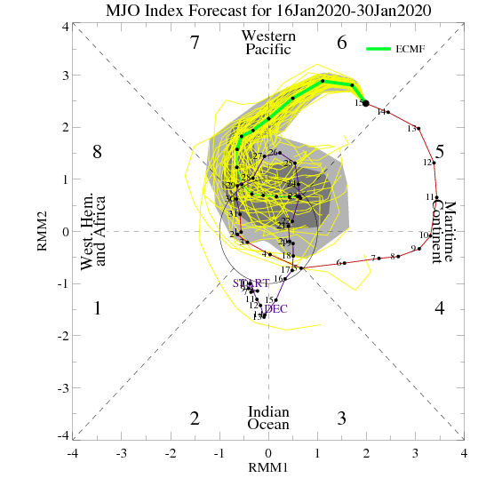
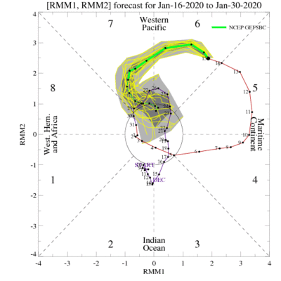
Those plots are picking up on a kelvin wave in p6. That’s why you’re getting the curl back then back to 8. By the start of February we will be in p8 then the wave looks to die. Will will probably be in cod after the 10th then climo nino takes over for February.
You can now see the members curling back. Those maps are so predictable.
-
3
-
-
2 minutes ago, bluewave said:
It actually goes beyond this season. Amplified systems usually adjust north over time. So when the storm is originally modeled to go through the Great Lakes, we are in a marginal spot to begin with. Any warmer or northward shift just adds to the milder outcome.That’s why our best snowstorms are often forecast to be just or our south or east in the long range. As we get closer, the heaviest snows begin to creep into our area. You can go back and look at our best snowstorms and see this forecast evolution.
Yep. Bad patterns bring bad results.
-
3
-
-
Yeah I think the biggest issue is the fact the waa is going north of the metro. So we are left with a band of snow for those south of CT. Best forcing is well north of the area
-
Eps ticked snowier also. Mean close to 3 for nyc
-
2
-
-
18z euro ticked colder. 3-4 from the city west.

-
3 minutes ago, Snow88 said:
Lovely 18z run
I have no clue why people would give you weenies. I mean are people trolling for warmth here or not looking at the pattern ahead.
It’s okay Anthony. I’ll survive
-
1
-
-
8 minutes ago, Allsnow said:
Happy Hour Gfs says congrats dca and ACY next weekend during the torch
Then a 95 blizzard on the 30th...obviously this will change but shows the potential
-
1
-
 2
2
-
-
Happy Hour Gfs says congrats dca and ACY next weekend during the torch
-
1
-
-
-
2 minutes ago, weatherpruf said:
Good point, others have observed that as well, no in-betweens, at least it seems that way.....I've said 8 inches was considered a big snow storm when I was a kid.
Yep. Historic cold in December 2017 to record snows in March 2018. On the flip side, record warmth in February 2018/2019 and now record warmth in January 2020.
I would be fool to not say that the earth has warmed. But imo the extremes are most noticeable.


Wintry mix potential weekend of Jan 18-19, 2020
in New York City Metro
Posted