Allsnow
-
Posts
26,462 -
Joined
-
Last visited
Content Type
Profiles
Blogs
Forums
American Weather
Media Demo
Store
Gallery
Everything posted by Allsnow
-
Gfs op is the snowiest member for Brooklyn NY lol
-
Euro more progressive but still Mainly rain for nyc. Frz rain for central Pa and Hudson valley
-
Ukmet 4/8 northern Pa into sne mainly rain for nyc
-
By 12z Friday it’s rain for nyc south. Frz rain north jersey. Gfs is on its own
-
Nice. But the gfs is completely on its own with that outcome and in this pattern you want it way south
-
Yeah, that low north of Japan will be further west to help pump the epo block
-
Exactly. The waves breaking and jet retraction
-
The low north of Japan imo is what’s influencing the pattern. It’s definitely not the mjo
-
No
-
Weeklies lock in the pattern through April
-
Full of win
-
Snow is gone and it feels beautiful outside currently
-
@40/70 Benchmark might get his revenge
-
Acy had their snowiest January on record
-
Yeah…the second storm crushed northern nj with 15-20. Nyc just missed the best of the ccb to its west
-
Yes please
-
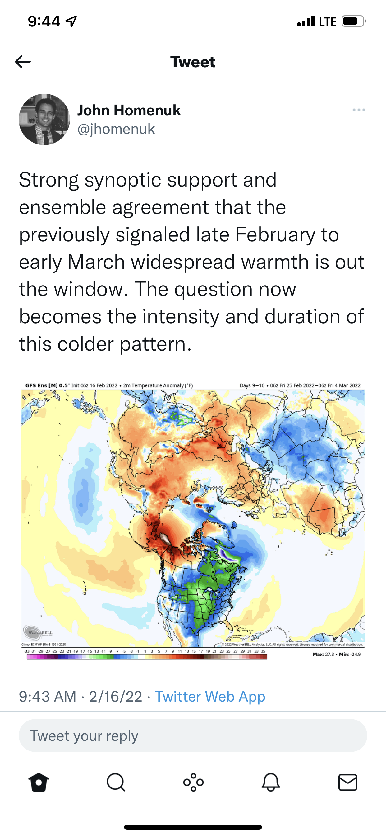
This doesn’t look like cold phases by March to me
-
Idk the true stats, but today feels like the coldest day of the season so far
-

2/13 Light/Moderate Snowfall Nowcasting & Observations
Allsnow replied to Northof78's topic in New York City Metro
Snowing again…been on and off since 1am. -
2/13 Light/Moderate Snowfall Nowcasting & Observations
Allsnow replied to Northof78's topic in New York City Metro
WWA extended for additional 2 inches here. Where was this event last month ugh -
2/13 Light/Moderate Snowfall Nowcasting & Observations
Allsnow replied to Northof78's topic in New York City Metro
3 Metuchen -
2/13 Light/Moderate Snowfall Nowcasting & Observations
Allsnow replied to Northof78's topic in New York City Metro
Probably our best rates of this sad winter. Will probably get 3-3.5 -
2/13 Light/Moderate Snowfall Nowcasting & Observations
Allsnow replied to Northof78's topic in New York City Metro
Best flake size of the winter so far…sad -
2/13 Light/Moderate Snowfall Nowcasting & Observations
Allsnow replied to Northof78's topic in New York City Metro
2-2.5 very beautiful outside -
Setting up a warm start to March