

Allsnow
-
Posts
24,135 -
Joined
-
Last visited
Content Type
Profiles
Blogs
Forums
American Weather
Media Demo
Store
Gallery
Posts posted by Allsnow
-
-
I’m not trying to rain on anyone’s parade. It’s a weather forum and you can track whatever you want. Imo the pattern looks unfavorable for significant snow in nyc for the next 2-3 weeks.
-
 2
2
-
 1
1
-
-
12 minutes ago, Snow88 said:
Agree
We dont want arctic air this time of the year. If so then congrats DC.
That’s simply incorrect. Having arctic air yesterday was the only reason you snowed.
-
1
-
-
17 minutes ago, Mersky said:
So a well timed high during a otherwise above normal regime led to snow yesterday, correct??
Yes. Because we had very cold air in Canada. I don’t see that In the next two weeks of January. The vortex and ridge in Hudson Bay will moderate Canada quickly.
-
1
-
-
6 minutes ago, Snow88 said:
Eps is +1 for the temp anomaly for day 10-15. That will work fine in January.

That’s Celsius Anthony


-
 3
3
-
-
3 minutes ago, Snow88 said:
People said the same thing about this timeframe and look , many coastal regions saw snow yesterday.
Eps is +1. That isnt a torch in January.
The storm this weekend is really close doe everyone .
Disagree. I remember posting about a over running threat last Saturday when it was in the 70’s. I even posted how the news will have that classic split screen weather segment. The cold artic high pressure was the only reason we snowed in yesterday’s set up.
-
1
-
-
Okay. This was the exact tweet. I agree for North Carolina it’s not a torch. It will be too stormy down there with a active STJ which will keep temps around normal. Imo that tweet has nothing to do with areas outside the southern US.
-
1
-
-
5 minutes ago, Mersky said:
That is still below freezing air in Canada. I know people love to look at the pretty red colors and think it’s a torch but it isn’t. A well timed high pressure system and a low coming across the south, which that clearly shows is a split flow, could still cause snow this time of the year. If that map was in early December or March then no. But marginal air masses can work in late January, early February.
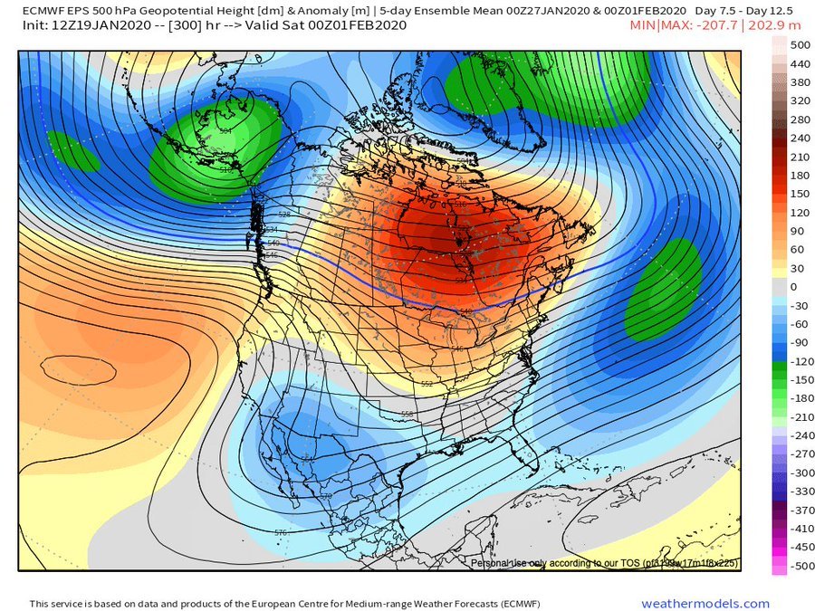
It would be a torch if we didn’t have a split flow. That ridge from Hawaii would be in the plains instead of the west coast. It’s not a torch but above normal for the majority of the conus. I expect very little for the coastal plain the next two weeks. The interior and nne is a totally different story.
-
1
-
1
-
-
6 minutes ago, Snow88 said:
With a storm threat next weekend. Not bad at all.
Nws mentioned about possible secondary development over the Carolinas.
We have a very marginal airmass with no artic air around. The eps mean has less then a one inch for our area. Those numbers increase out by northern Pa and upstate ny.
So in short, I would be shocked to see next weekend workout for the costal plain.
-
2
-
1
-
 1
1
-
-
1 minute ago, Mersky said:
That isn’t a torch either so Webb is correct.
I didn’t say it was a torch but very much above normal. That’s a 7 day mean and after Thursday we don’t have another below normal day. (If correct) I don’t know what exactly Webb said so I’m not going to question it.
The flow looks very progressive with above normal temps the next two weeks.
-
1
-
1
-
1
-
-
5 minutes ago, Snow88 said:
Eps has been awful this whole season and yet people praise it all the time.
This is simply incorrect. It hasn’t been any worst then the other guidance. The GEFS have been too cold in the long range.
-
1
-
1
-
-
6 minutes ago, Snow88 said:
Really because Eric Webb think the eps doesnt look bad at all.
The Atlantic doesnt look bad at all
I don’t know what he is saying but that is a ugly look on the eps. Vortex in ak with a +nao. The only thing that makes it cooler by him is the split flow. If that’s what he is saying.


-
1
-
1
-
-
23 minutes ago, Isotherm said:
Thanks, Chris. And great explanation above as well. Another factor supporting the notion of potentially a better window of opportunity late Feb-Mar is the wavelength alterations. The shorter wavelengths in late winter-March can often render than base state -PDO/-PNA less influential. I do not have the data in front of me, but I would wager to assert that a proportionally higher % of snow events in March featured a -PNA compared to Dec-Jan-Feb. @uncle W may have those statistics.
Until late February, we may continue to battle this unpropitious base state.
Yep. I’m pretty sure we gain a phase of the mjo that is cold in March. I believe it is p3.
Another year with a favorable mjo pass that will result in a unfavorable response. We could see some hits on the Pv starting in mid February that will line up with your timing well.
-
1
-
-
-
4 minutes ago, EastonSN+ said:
Weeklies will be interesting tomorrow
I would expect them to kick the can on any favorable pattern until mid February
-
1
-
-
Another rathe ugly eps run. As the vortex sits in ak with a ridge near Hudson Bay. Canada is really flooded with above normal pac air. The ridge from Hawaii is into the west coast. This look is locked on the eps all the way into the first week of February.
-
1
-
1
-
2
-
-
On 1/18/2020 at 8:55 AM, Allsnow said:
Final call
KNYC 2
KEWR 3
KLGA 1.5
KJFK .9
KBDR 4
Actual.
Knyc 2.1
Kewr 1.8
Klga 1.9
kjfk 1.6
Kbdr 2.5
Not a bad forecast for this storm. I was too high at ewr (lull hurt) and too low for Long Island (no lull) I wish they could all go this well lol
-
2
-
-
6 minutes ago, bluewave said:
These light snow events before mixing has been the default pattern since last winter. Very 70’s to early 90’s like. You learn to appreciate any snow that you get.
Yep. The past two years I have been glued to CC on RadarScope tracking the mix line. I’m longing for a all snow event lol.
Nice event either way in a crud winter. Good tracking with you guys. Time to go shovel the ice crud off my driveway. Enjoy the snow to those that are still getting it.
-
1
-
-
7 minutes ago, RU848789 said:
Damn, same here with sleet snow mix (mostly sleet) - by the cc-radar a tongue of sleet looks to have developed along 78 from Allentown to Somerville and then along 287 to Perth Amboy. Hoping the precip behind it, which is not showing a sleet signature is back to snow (with heavier precip - will see shortly as heavier precip is on our doorstep) and not freezing rain, since it's 26F at the surface and that would be a mess.
Unfortunately don’t think we will get saved like last March lol. The sleet line blew through here and currently getting beat back south of ewr. Nice winter night either way.-
3
-
-
1.5 sleet now ugh
-
2 minutes ago, Animal said:
Yup...waiting patiently for snow.
That’s not snow in eastern Pa. it’s all sleet which is reflecting on radar.
-
1
-
-
Just now, weatherpruf said:
The big disappointment for me has been the performance of my Sears snow blower. If it can't thrown an inch more than a few feet, I mean really...
Odd.....this is a powdery snow also. How’s the belt on it?
-
I doubt we see much sleet now with the back edge by Abe. Should rip this evening for nyc and nnj
-
1
-
-
Love mod snow on a January evening. It’s been way to long.
-
Mod snow currently
huge flakes. Very cool to see
-
1
-


January 2020 General Discussions & Observations Thread
in New York City Metro
Posted
I was referring to his statement about how Arctic air in January keeps storms to are south.
The system stays to our south on the 12z euro and the big city’s along 95 get nothing but rain.