

Allsnow
-
Posts
24,135 -
Joined
-
Last visited
Content Type
Profiles
Blogs
Forums
American Weather
Media Demo
Store
Gallery
Posts posted by Allsnow
-
-
35 minutes ago, psuhoffman said:
Btw wrt the mjo...I don’t think it’s going to save us but I also don’t think it’s going to kill us in Feb. After a brief nudge into 6 (and even that signal is conflicted if you look at the actual convection, it likely goes null. Other factors are likely to drive the bus in Feb imo. Doesn’t mean they will be any better but I suppose they can’t be any worse so there’s that.
Yeah, I think this is the correct thinking. Latest roundy maps has the current wave croaking in 7/8. Then they start keying on a kelvin wave in p5. With lots of substance in p6, looks like it will head back towards cod then eventually a wave forms in p1/2.

As for the weeklies, we need to get that look inside day 7 for me to believe it. If the AAM relaxes then perhaps typical February nino takes over.
-
 1
1
-
-
7 minutes ago, Brian5671 said:
Weeklies showed this all last winter and the big pattern never materialized. Color me skeptical
I agree. Until I see it inside day 7 color me skeptical as well. It takes the cold pool from Ak and moves it into the conus.
-
 1
1
-
-
6 minutes ago, White Gorilla said:
What does this translate locally?
It had a big hand in Why the models went away from the cold stormy look in the long range. Look back a bit for @bluewave posts. He had some great information on it.
-
1
-
-
FWIW the weeklies Flip the Pattern by February 8th. Huge -epo/+pna with some higher hgts near Greenland. It’s basically the end of the eps rolled forward off my previous post. It keeps that look into March.
Is this correct? Idk. I think the kelvin wave will weaken in p5 as the mjo heads towards cod. As for the strat looks like activity picks up there towards mid month.
-
 1
1
-
-
-
33 minutes ago, bluewave said:
This is a continuation of the misalignment discussion. Niño-like ridge near Hudson Bay and Niña-like ridge NE of Hawaii. Almost a combination of the 97-98 and 11-12 patterns at 500 mb to close out January.


Just not in sink. I see improvements on the 11-15 day eps but that’s la la land. It wants to kick the ridge to Greenland and higher hgts move into Ak. Something to monitor as we get closer. It will take time to flush this pac air out. By day 15 on the eps we are still above avg with those changes.
-
1
-
-
Well at least we are done with the cutters now that we have Hudson Bay ridging lol
-
Just now, PB-99 said:
Day 9 - 16
Plus 2 to 3 F
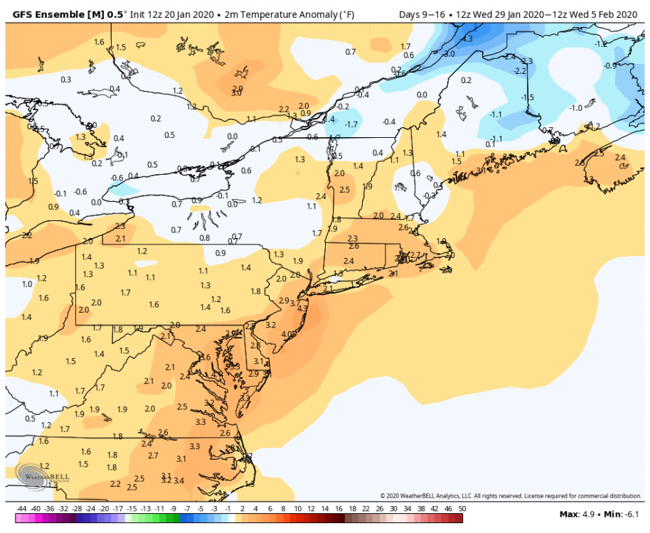
Which have been documented well that it’s been too cold in that 11-15 day range. Perhaps some hints of change by Feb 5th but that could be rushing it.
-
1 minute ago, PB-99 said:
There`s no torch on the GEFS through it`s 15 days.
It`s plus 3 to 5 day in the day 5 - 12 the period and in late Jan , it`s not warm.
Here is how you end
-
Starting to see some hints of the lower hgts moving out of Ak at the end of the eps/GEFS. I’m sure this will not be a quick process and can kicking might occur.
-
16 minutes ago, Isotherm said:
Unfortunately, the continental USA will be devoid of polar air during the time-frame of greatest PNA amplitude. So, even conducive storm tracks could imply rain rather than snow for the I-95 corridor. Due to the fact that we are at the climatological height of winter, marginal airmasses can potentially work for interior areas.
Yep. The pac is the only reason we are not getting a full on torch. Shades of 97-98 with a ideal storm track but a putrid airmass.
-
2
-
-
5 minutes ago, HVSnowLover said:
Not a great sign of the GFS is the only model showing the colder solution. However the GFS did the best overall with the most recent storm, the other models had the primary too strong and only had brief snow to rain a week out.
That’s incorrect. The gfs way to snowy and wet for the area. The nam did the best on thermals.
-
7 minutes ago, purduewx80 said:
12Z UKMET has temps approaching 50 in the city as the triple point passes through Saturday evening. Snow is restricted to the very highest elevations well outside this forum.
Similar to the cmc. Snow is restricted to NNE.
-
 1
1
-
-
7 minutes ago, rossi said:
All we need is 50 to 100 mile east movement and we all get plastered
That would not change the fact that we have a onshore flow with a bad airmass. This is rain regardless for the coast. Northern Pa and Upstate ny have the best shot.
-
1
-
-
8 minutes ago, Snow88 said:
Gfs is really good for the interior

Perfect low track for the metro area and 100% rain. Shades of 97-98.
-
1
-
-
30 minutes ago, HVSnowLover said:
You don't need an artic high to snow in the middle of winter, we've seen places to our south and east get a snow event two weeks ago. You just to get lucky with a storm track here or there, overall most storms will track to our NW but it can still snow in a bad pattern especially in the middle of winter
Like it snowed yesterday in a bad pattern with a arctic high.
-
Mjo still looks to get into 7/8 to start February then the kelvin wave gets stronger in p5. Lots of substance in p6 so would not be shocked if that wave collapsed into cod

-
1
-
1
-
-
4 minutes ago, Mersky said:
Ask people in DC if they would change anything about 2009-10. I doubt you will get many complaints that December and January were slightly above normal. Truthfully how many winters are wall to wall cold around here??
Outside winters like 95-96/13-14 not many. That’s why we avg what we avg here for snow. I don’t follow why I need to survey people from DCA about winter 09-10? All I’m saying is that was Nino climo helped by a uber block in February and December.
-
Just now, Mersky said:
Sir you are proving my point and you don’t even know it. 82-83 huge February snowstorm. 2009-10 huge mid Atlantic winter for snow. It can snow when it’s warm up north.
If proving your point means the next two weeks look meh for snow and canonical nino is warm north/cold south, then sure. Obviously, those last two posts from you were trying to twist my words.
Let’s not forget about the uber blocking in 09-10 in a otherwise warmer then normal winter. December 09 and January 10 were above Avg with little snow outside December 20 09.
-
1
-
-
3 minutes ago, Mersky said:
It was warm up north in 2009-10. Rained in Maine while DC had their snowiest winter ever. Your point???
1 hour ago, Isotherm said:Yes, I agree with your post here and the others recently. Regarding the putative canonical Nino-look and seasonable temps in the South, that doesn't necessarily imply favorable pattern for snow in the Northeast I-95 corridor. Classical Ninos are typically seasonable temperature wise across the southern tier of the CONUS due to frequent clouds and precipitation.
For example, see 97-98, which wasn't a torch for the southern half of the country, but it certainly wasn't snowy for our region.

Similar look with 1982-83.

-
8 minutes ago, Mersky said:
Wait wut? Loop a operational model past 5 days?? Lol and you are 100% wrong on the strength of the nino not making a difference in temps.
For the next two weeks it fits the h5 pattern well. A moderating northern tier with a active progressive stj. Just because it doesn’t show what you want doesn’t make it wrong.
Yes, in that moderate 09-10 nino it was bitterly cold up north.

-
5 minutes ago, Mersky said:
Yes those 20’s in Canada will be hot for sure
Yep, about on par for a normal high in areas north of nyc.
-
12 minutes ago, Isotherm said:
Yes, I agree with your post here and the others recently. Regarding the putative canonical Nino-look and seasonable temps in the South, that doesn't necessarily imply favorable pattern for snow in the Northeast I-95 corridor. Classical Ninos are typically seasonable temperature wise across the southern tier of the CONUS due to frequent clouds and precipitation.
For example, see 97-98, which wasn't a torch for the southern half of the country, but it certainly wasn't snowy for our region.
Similar look with 1982-83.
Yep. @bluewave made a terrific post about the +AAM and ridge by Hawaii. This played a big part in the colder pattern going poof.
As you have said recently you can’t have biases in weather. If the pattern looked cold and snowy we both would be posting about it.
-
2
-
-
1 minute ago, Mersky said:
97-98 was a strong nino. Of course the country torched. You can’t compare that nino to this one.
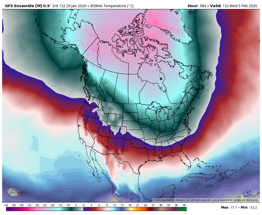
No matter the strength of nino the result is warmer northern tier with cooler south. With the vortex in AK it’s even worst. Just loop the 18z gfs it illustrates the up coming pattern very well.


January 2020 General Discussions & Observations Thread
in New York City Metro
Posted
If I had to guess I think any change will be more towards mid February. Basically in line with @Isotherm thinking. Probably more of a pattern for sustained cold.