-
Posts
24,135 -
Joined
-
Last visited
Content Type
Profiles
Blogs
Forums
American Weather
Media Demo
Store
Gallery
Posts posted by Allsnow
-
-
21 minutes ago, 40/70 Benchmark said:
Strat was awful in 2015, but I'm not sure what your point is. I think most understand that you can get by without it, but its insurance against what we are now enduring.
The big PNA failed this month..is the PNA voodoo?
The Pv gaining strength coupled with the strat allowed for the coldest air to stay by the pole. I’m not saying we need a voodoo SSW but a better alignment of the pv would help get colder air into the conus. Currently we have a putrid airmass for these threats coming up. Obviously NNE/Sne can snow in the heart of January in lots of patterns, but for us down here we need a better airmass.
The huge pna obviously was model fantasy but it has improved to allow more of a southern storm track. We don’t have a -pna anymore and if we did it would have definitely sent more mild air across the conus with the vortex in Ak.
-
5 minutes ago, CoastalWx said:
That would be serviceable down there at the end. There is a window near and after that time where we could go on a run. Not sure how long, but I’ve heard that talk.
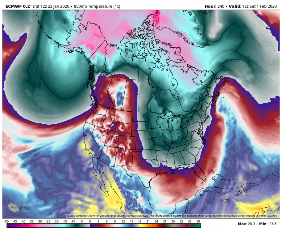
Yep, hearing the same whispers. The strat guys think the pv starts to weaken in the middle of the month. I don’t think the mjo will be a big player going forward. I just really want to see that vortex get punted. I think that’s why the weeklies looked good after the 5th. It has the pv more elongated to provide us will cold air and a pac ridge. It’s basically the look at the end of the eps rolled forward.
For nne/sne the airmass is definitely serviceable next week.
-
 1
1
-
-
Just now, CoastalWx said:
There's the AK cold dump. She's not gonna let us out.
Yeah the eps is weakening it but not really punting it out yet. Still consistent with a cold dump around the 5th.
For down here it’s a shame we have such a putrid airmass. The pacific has improved which is allowing for a better storm track.
-
1 hour ago, PB-99 said:
Yes, but it originates from the pac as the vortex is wound tight with all the cold. Nice pna spike but a crap airmass. The eps has less then a inch for that timeframe
-
 1
1
-
-
12 minutes ago, snowman19 said:
I think if there is to be a change it’s post 2/15, more like late/end of February. Vortex over AK setups just don’t flip overnight, they always stay longer than expected, then you have to seed Canada with cold again and scour out the PAC maritime air....that’s takes some time. Come March, with the wavelength change, IO forcing is actually cold, not warm anymore, so if we have IO forcing at that point, I’d expect a cold March, yet again
Yeah the vortex is going to weaken eventually. I think more towards the end of February as well. I believe @Isotherm thinks the same.
Im more interested if the cold shot around the 5th gets punted. The weeklies and eps have been consistent in showing this.
-
 2
2
-
-
The 12z euro has two costal storms next week in perfect locations that are 100% rain for the metro. Can’t make this up lol
-
 2
2
-
 2
2
-
-
5 minutes ago, PB-99 said:
Can we get back there in about a week on the Ry / Plots
Early Feb ?
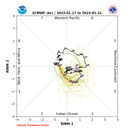
The roundy plots have the kelvin weakening and moving closer to the colder phases. Then around feb 10-15 we are in p1/2.
-
 2
2
-
-
-
39 minutes ago, bluewave said:
Nice post. It really looks like the MJO 3 in mid-December kicked off this extreme +EPO. Also notice how the record MJO 4-6 in January seemed to reinforce this pattern. Maybe we’ll need a strong enough phase 1 at some point in February to reverse this. But there could be other variables that could maintain the +EPO or change it more negative as move though February.
Yep. It’s been a combination of a lot of different things that hurt this winter. The Pv that coupled with the strat was a bigger factor then I anticipated.
Going forward I think if we see the vortex weaken and move out we will enter more of a sustained cold pattern. But at this point I need to see that to believe it lol. It’s a shame too because we finally got a nino response with a +pna.
-
 2
2
-
-
1 minute ago, PB-99 said:
Anthony the pos PNA is mitigated by that Neg in Alaska , the air that is being being forced through W Canada is PAC air, it warms Canada.The PNA is not connected to the Arctic region.
Yes.
The only reason it’s not 50’s and rain is because of the pna ridge. This is the end of December 2019 pattern with a better pac.
-
 3
3
-
-
1 minute ago, Snow88 said:
For when ?
Having the pna in our favor is a big step in the right direction.
The next two weeks.
And no it’s not when the airmass is putrid
-
2 minutes ago, Snow88 said:
What did you tell me ?
The airmass would be too warm for snow in Brooklyn ny.
Their was literally 2 pages worth of you arguing with me that it was cold enough and webb said that’s a cold look in Hilton head.
-
 2
2
-
 1
1
-
-
5 minutes ago, NEG NAO said:
Many of our significant snow storms occurred while the MJO was in the COD
Yes, because other factors are controlling the pattern.
-
 2
2
-
-
10 minutes ago, PB-99 said:
Hey man, you have been spot in here. I don`t care what Negative`s show up in the lakes and N/E in the L/R if you don`t eject the Vortex out of Alaska, you are just seeding a trough with crud air.
Thanks. I get it, people want results in there backyard. I’m just as frustrated as everyone. We are basically kicking 2 weeks of peak snow climo. @Rjay put it best by saying we flip to just another trashy pattern.
I tried to tell @Snow88 and @Mersky, but it was like talking to a brick wall.
-
 5
5
-
 1
1
-
-
Just now, NEG NAO said:
whats going to "rule the roost " in February is not so much the MJO- agreed - but the AO and NAO - each of these storms are taking tracks that many times deliver snowstorms here BUT one of the main ingredients is missing - the stronger HP to the north that stays locked in - with this pattern they escape need some type of blocking ,,,,,,,,,,
The last few days I have been posting how the airmass is putrid for these storms. It’s a product of the vortex moving into Ak and the cold on the other side of the globe. If we had blocking all it would be doing is blocking a pac airmass.
At the end of the eps and Geps a piece of the cold breaks off and enters the conus around the 5th. Is this correct? Idk. February will go the way the Pv goes. If the Pv moves out of ak the ao will improve. The ridge in central might move into Greenland around the 5th also. Which will be pushed out by the vortex.
-
 1
1
-
-
18 minutes ago, NEG NAO said:
It’s going to get close to 8 then weaken into cod. The kelvin wave in p5 will loop back quickly as we go towards p2 by middle of February.
I don’t think I was that far off with it. Unfortunately, other factors are going to mitigate the response we will have. The -mvp and Pv is basically killing our winter. All the cold is on the other side of the globe next week. If we didn’t see the Pv couple with the strat this would be a very snowy period. We would have a active stj with cold around. Instead we have a crap airmass with costal storms.
If we are keeping tabs i did say the storm track would improve after the 20th. Most of the threats the next two weeks are taking good tracks for us.
-
 1
1
-
-
I don’t think the mjo will be ruling the roost for February. It looks weak overall and perhaps closer to The end fo February we see the wave in P2 take over.
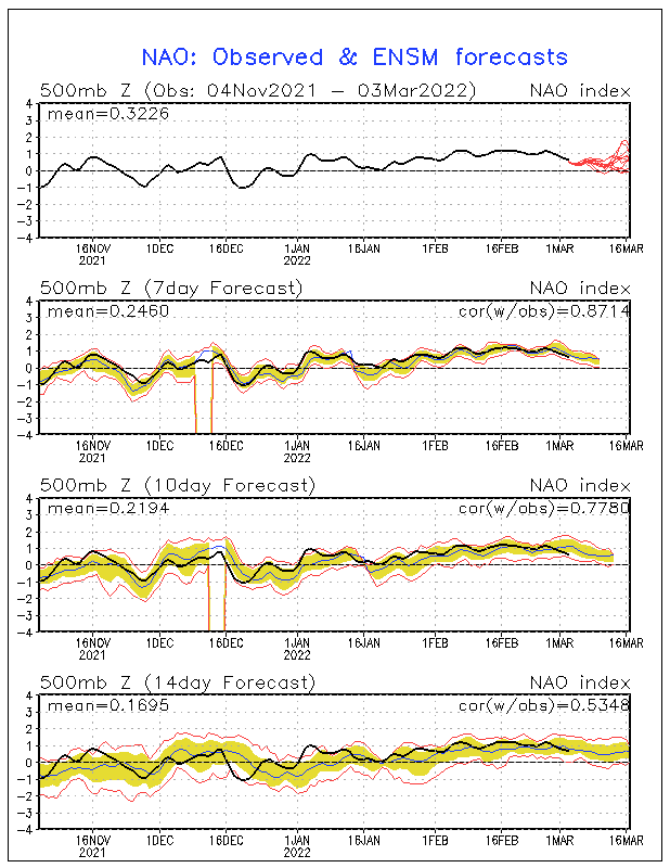
February will be dictated by other factors such as the pac and weakening of the Pv. We need to get the vortex out of Ak.
-
 1
1
-
 1
1
-
-
-
1 minute ago, Allsnow said:
The EPS is incredibly snowy for northern Pa and southern Ny. Probably the snowiest I have seen them all year. 7-8 on the mean
For costal sections and the metro area it has 1 inch total for the next 15 days. So yeah, close the shades until further notice
-
 1
1
-
 5
5
-
-
The EPS is incredibly snowy for northern Pa and southern Ny. Probably the snowiest I have seen them all year. 7-8 on the mean
-
 2
2
-
-
Just now, PB-99 said:
Tim, why the quick wave in 6, is that a real signal on the Roundy plots ?
It’s a kelvin wave that all the rmm plots are jumping on. The roundy plots move it quickly ( kelvin waves move quickly regardless) and then a mjo wave forms in p1-2 by the 10th.
The mjo is so weak next month that it will be other factors that will control the pattern. We need to see the PV weaken or change positions.
-
 1
1
-
-
-
2 minutes ago, bluewave said:
The general public is going to be very happy when they see their heating bill. Only the 10th time that NYC averaged 40 degrees or higher over the last 30 days.
Time Series Summary for NY CITY CENTRAL PARK, NY
Click column heading to sort ascending, click again to sort descending.RankEnding DateMean Avg Temperature Dec 22 to Jan 20Missing Count1 2007-01-20 43.0 0 2 1932-01-20 42.6 0 3 1950-01-20 41.6 0 - 1933-01-20 41.6 0 5 1937-01-20 41.4 0 6 2006-01-20 41.0 0 7 2020-01-20 40.8 0 8 1890-01-20 40.4 0 9 2016-01-20 40.3 0 10 1995-01-20 40.1 0 Yep, and We are probably 2-3 weeks away from another arctic outbreak.
-
 2
2
-
-
14 degrees. My coldest temp of the winter
-
 1
1
-




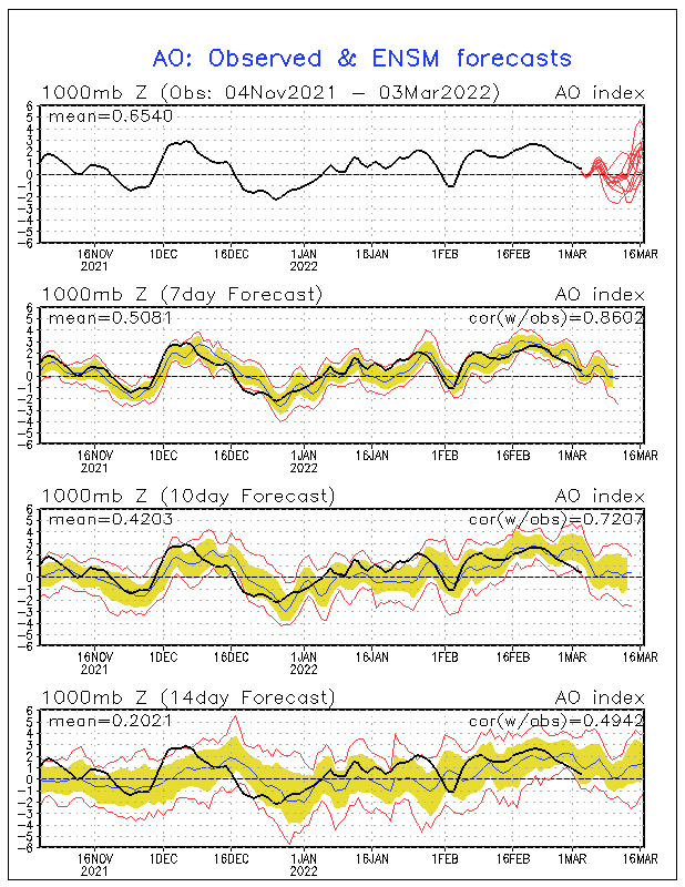


January 2020 Discussion
in New England
Posted
It most of our snowy winters (down here) we didn’t have that warm blob in the NPAC. IMO I think warm waters in that spot helps Lows sit south of Ak. So yeah, I’m not a big fan of that argument.
Don't you think the PV being so strong has kept us mild overall? It’s been pretty toasty across the country since mid December.