

Allsnow
-
Posts
24,161 -
Joined
-
Last visited
Content Type
Profiles
Blogs
Forums
American Weather
Media Demo
Store
Gallery
Posts posted by Allsnow
-
-
20 minutes ago, jm1220 said:
Oh without a doubt. Even the difference between my old place on the immediate south shore and where I live now is comical at times. On Tue, there was no snow left at all from the weekend minor event SWFE in Long Beach but a good amount left where I live now, almost full coverage some areas. It’s a 45 minute drive between both.
Yep, it’s climo. And more often then not climo will win out.
-
 1
1
-
-
8 minutes ago, NYCweatherNOW said:
Are you saying it’s game over for the city 100%?
I think the set up and airmass favor areas of the interior/sne. Could nyc thread the needle and get it to work? It’s possible but I would bet against it. I think it’s obvious the set up is bad when even the models that show hits are not snow for Nyc.
-
 2
2
-
-
Just now, jm1220 said:
Boston has 14.6” I believe and NYC 4.8”. But plenty of others around have more-I’m up to 9.5” for the season, EWR has 6.9”, etc. It’s been lousy for everyone and just about everyone’s below average except around Albany which got crushed by the early Dec storm.
I believe interior sne is around avg or a bit above. The point is in marginal set ups they will often have more wiggle room. Take the December storm for example. That was a marginal airmass with white rain in the city. Sne and Albany got crushed.
The point of the post wasn’t to compare who is having a worst winter. It was to show how in marginal set ups they often have more room for error.
-
 1
1
-
-
8 minutes ago, CPcantmeasuresnow said:
Somewhat of an exaggeration, depending on what you define as way more. Boston averages 17 inches more per season than NYC but 17 inches less than Albany at the same latitude. No one ever seems to remember when their easterly locations work against them too.
if you're just referring to the city and the coastal plain of NJ what you say is true, but most areas N&W of NYC and even a few spots on the North shore of LI average the same or more snow per season than many parts of SNE, especially coastal CT, RI and MA.
Yes, I was referring to the costal plain. We have spots to the north and west of the metro that probably Avg more then Boston. But those same locations fail in comparison to a place like Orh.
The point of the post is their longitude and climo is more conducive for snow in a marginal set up. I believe currently Boston has 17 inches to nyc 2.8?
-
Just now, Snow88 said:
Exactly
This thread is a disaster. Time to read posts in the SNE thread where they think the threat isnt over yet.
The threat isn’t over for them because of there latitude and climo. They can get away with way more imperfections in a set up then we can. This is why they avg way more snow then us.
-
3
-
 1
1
-
3
-
-
The 12z euro is OTS as the pna ridge gets beaten down by the wave train/vortex.
-
1
-
1
-
-
1 minute ago, Allsnow said:
The main forcing is currently in 8 but we still have convection in 6. The +AAM and Pv orientation is negativity effecting any results from p8.
We will be in 2/3 to start February. With some strat hits we should get into a better airmass by the 5th.
Just now, tombo82685 said:I think its a combo of mjo that produced a record +AAM event that causes the pac jet to go on roids. It doesn't help that you have th intense goa low that also tightens the pac jet. That doesn't allow the pna ridge out west to build. With that being flatter it prevents the northern stream s/w from digging further south. Also think bad strat alignment has cut off cold air supply. That will change after the 5th as the strat alignment is more favorable for -epo development.

-
1
-
1
-
-
14 minutes ago, White Gorilla said:
Is the MJO projected to go to into phases 1-2 by then? How much is the pattern MJO driven currently?
The main forcing is currently in 8 but we still have convection in 6. The +AAM and Pv orientation has negative effects on the response from p8.
We will be in 2/3 to start February. With some strat hits we should get into a better airmass by the 5th.
-
2
-
-
Just now, PB-99 said:
You will have a - EPO and LP/ LP`s running along an Arctic Boundary.
Those work here.
Yes. Legit arctic airmass with lots of activity
-
1
-
1
-
-
1 minute ago, White Gorilla said:
In other words a lot has to go right to make this work and very little has to go wrong to make this not work.
Exactly. Not impossible but long list of negatives that argue against it.
-
1
-
-
9 minutes ago, winterwx21 said:
Models are showing better cold air moving in around February 6th. Hopefully we can cash in on that. Looks like a much better chance that something can work out the end of the first week into the second week of February. This weekend, as you and most people here have pointed out, is a true thread the needle that has only a very slim chance of working out. Really looking towards that 2nd week of February for a much better chance.
I agree. As I mentioned a week ago, that timeframe holds the most promise.
-
1
-
1
-
-
Just now, White Gorilla said:
Yes I saw that. That makes it very difficult for phasing to happen earlier in the East given the trough alignment, unless other factors kick in I guess. Even with a raging Pacific, how does the NAO going negative potentially compensate?
It slows the storm down and allows it to bomb out. Unfortunately, it does little for the airmass concerns. You would need a perfect ULL track/close off to allow dynamics to overcome bl issues.
-
4
-
-
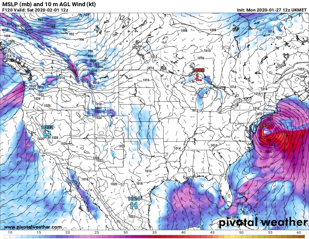
990 low in a perfect spot on the Ukmet and this is the result. Putrid airmass

-
1
-
-
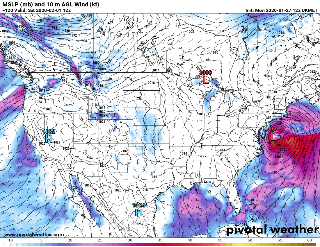
Just now, Rjay said:
.thumb.png.24d5c7e98a3c038b59b38919235bf8a3.png)
Looks to be all southern stream. I would think temps are warm for the coast.
-
1
-
-
Just now, Barman49 said:
Yeah. The track would work this time if year if there was some cold air in place. Relying on the storm to track perfectly and bomb to make its cold air is really threading the needle. Like you said especially with no NS interaction.
Sent from my GM1925 using Tapatalk
Great post. It’s not impossible but with no northern stream you’re relying strictly on dynamics to get it done.
-
1
-
-
27 minutes ago, Barman49 said:
LP is way too close to the coast with no cold air it's rain for most.
Sent from my GM1925 using Tapatalk
The icon is making this all southern stream with no northern stream involvement. This helps in really warming temps along the coast despite a decent track.
-
1
-
-
Pna a lot sharper on the 12z gfs. But trough is still positively tilted.
-
Latest Mjo roundy plots have this going p1-p2-p3 (all cold for February) Then 4-5-6 for mid month. Depending on the amplitude in the warm phases will determine strength of southeast ridge and storm track.

-
3 minutes ago, bluewave said:
Yeah, timing of the phase and surface and UL track will be critical.
Yes! We just witnessed a ULL trend 200 miles north at this time last week for the Saturday rain event.
-
Everything continues to look good the first week of February. We probably will get a cutter/cold front around the 3-4 before the cold spreads East. That timeframe between the 5th-8th continues to look conducive for something.
-
1
-
-
Just now, bluewave said:
We would probably also need the UL to close off right over the area to make up for the lack of any high pressure to the N or NW.
Yep. Need it’s dynamics to overcome the meh airmass/high sliding East. Lots stacked against this for the coast. But it’s not impossible. Great post.
-
1
-
1
-
-
Just now, Snow88 said:
Yes. That's why this storm is going to come down to timing.Long ways to go.
You want to see improvements out west with the ridge. (Not impossible 5 days out) This will allow the northern stream to dive in further south.
The ukmet was a southeast mass hit and the flow is too progressive.
-
3
-
-
24 minutes ago, NEG NAO said:
exactly - a prime example is this along with the other threads directly related to Boxing Day KU 2010
We had a completely different h5 set up for Boxing Day lol. Just because it trended west does not automatically make it comparable.
The issue is the progressive nature of the flow { wave spacing and vortex} all killing the sharpness of the ridge.
-
1
-
1
-
-
Euro continuing its attack on the strat. Now is very close to a split at day 10

-
1
-
.png.d2ae1fe957998206ea3426213d479cb4.png)


Mid to Long Range Threats
in New York City Metro
Posted
No it’s not........
unless light rain is a big hit