

Allsnow
-
Posts
26,403 -
Joined
-
Last visited
Content Type
Profiles
Blogs
Forums
American Weather
Media Demo
Store
Gallery
Everything posted by Allsnow
-
This week was always supposed to peppered with sloppy events. I consider it a win that NYC got 1 inch last night off a very meh event. The bigger events are now inside day 10 and it’s much better then the ensembles showing cutters/mild weather
-
The eps snow mean still 12-13 for the metro. The highest I have seen it since February 2021
-
24 hour snow mean for a day 9 threat. Impressive
-
Frz rain will not be a issue around the metro
-
It just shows the spread currently for something 9 days outs. The warmest of models still give nyc a significant snowstorm next week before any type of changeover
-
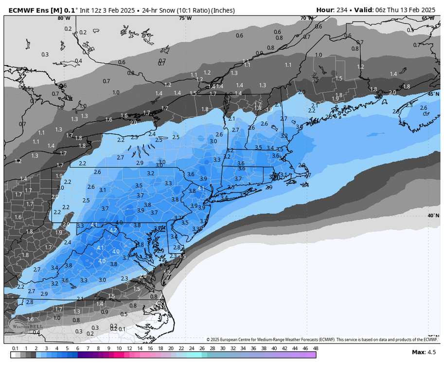
 Euro 2-4 with the most in central nj
 -
Euro was at best an inch of slop before rain.
-
Regardless if we get a true ssw or just a displacement it will be very beneficial to continue snow/cold threats. That annular charts showing what looks like paint dripping is a good sign that the effects will Work its way down to our sensible weather. This month will not be a typical Nina base February like you and I both thought would happen.
-
CMC and Euro Ai have it suppressed its 9 days away
-
The next 14 days have been very snowy on all the ensembles. You have swayed with the wind the past few days on every model run. The threat for next week has been very consistent on the models and yes lots of spread because it’s over a week away…
-
Solid advisory event for the city and immediate burbs
-
Yeah, like a norlun it will move around the next few days. Short range models definitely hinting at a burst of accumulating snow in the metro before a change to ice/rain
-
1 inch yesterday 6.8 YTD
-
Pretty good consistency from the ensembles of a costal threat around that timeframe
-
Both gfs and cmc big hits for the 12th That date has been so steady on the guidance
-
A few inches Wednesday night now
-
-
HRRR hasn’t been good this winter… it’s been late to the party on the few events we have had


