Allsnow
-
Posts
26,403 -
Joined
-
Last visited
Content Type
Profiles
Blogs
Forums
American Weather
Media Demo
Store
Gallery
Everything posted by Allsnow
-
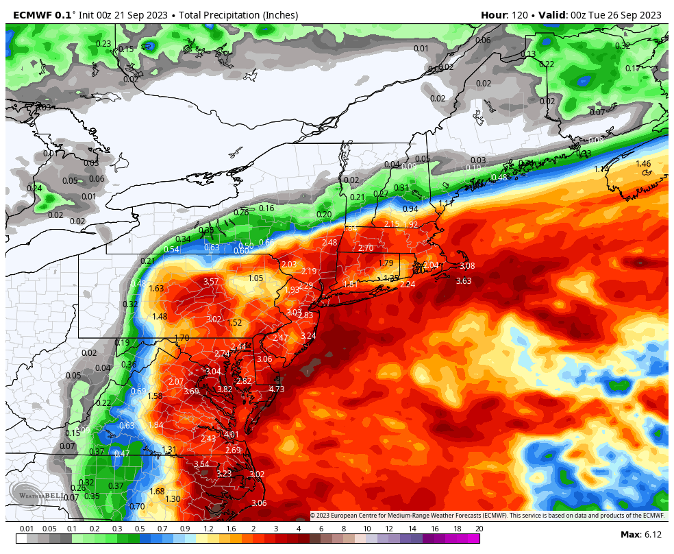
Eps mean 2.00 for nyc
-
Icon way west as posted above
-
Ends up being a brush with second low….very little rain outside the beaches
-
Euro swings and misses on the rain Saturday but might go the gfs route here with low down south
-
Euro more developed with the low off the southeast coast this run
-
Yup. Trending towards euro. It develops the low better down south then the euro
-
Looks a lot like the 00z euro overnight
-
06z euro weak and east….
-
We might salvage Sunday as this costal storm is becoming more of a Saturday storm
-
51 which is the coolest of the month here
-
18z euro further west at Hr90. It would definitely bring rain into the area if it went out further
-
Eps is still close to the coast with over a inch on the mean for nyc fwiw
-
The high pressure to the north might limit how far north the rain gets….just something to watch for now
-
This wet pattern just doesn’t want to stop
-
Yup. Gfs on its own again
-
-
Euro bust!!!
-
Yup. Never cleared out like the NWS said it would this afternoon
-
Ended up raining most of the day
-
Up the coast from the map you posted would be into eastern Pa. You would need a high to the north just to get a decent front end. The high itself doesn’t dictate low track in any month
-
If by interior you mean West Virginia, The mid levels would torch all the way into central Pa and Ny with a low into Va
-
Still raining here 1.76
-
You will