-
Posts
26,403 -
Joined
-
Last visited
Content Type
Profiles
Blogs
Forums
American Weather
Media Demo
Store
Gallery
Everything posted by Allsnow
-

Two Mdt to high impact events NYC subforum; wknd Jan 6-7 Incl OBS, and mid week Jan 9-10 (incl OBS). Total water equiv by 00z/11 general 2", possibly 6" includes snow-ice mainly interior. RVR flood potential increases Jan 10 and beyond. Damaging wind.
Allsnow replied to wdrag's topic in New York City Metro
Mixing line has stopped for now- 3,610 replies
-
- 2
-

-
- snow
- heavy rain
- (and 5 more)
-

Two Mdt to high impact events NYC subforum; wknd Jan 6-7 Incl OBS, and mid week Jan 9-10 (incl OBS). Total water equiv by 00z/11 general 2", possibly 6" includes snow-ice mainly interior. RVR flood potential increases Jan 10 and beyond. Damaging wind.
Allsnow replied to wdrag's topic in New York City Metro
Definitely. Close to inch here with roads covered- 3,610 replies
-
- 2
-

-
- snow
- heavy rain
- (and 5 more)
-

Two Mdt to high impact events NYC subforum; wknd Jan 6-7 Incl OBS, and mid week Jan 9-10 (incl OBS). Total water equiv by 00z/11 general 2", possibly 6" includes snow-ice mainly interior. RVR flood potential increases Jan 10 and beyond. Damaging wind.
Allsnow replied to wdrag's topic in New York City Metro
Story of my life- 3,610 replies
-
- 1
-

-
- snow
- heavy rain
- (and 5 more)
-

Two Mdt to high impact events NYC subforum; wknd Jan 6-7 Incl OBS, and mid week Jan 9-10 (incl OBS). Total water equiv by 00z/11 general 2", possibly 6" includes snow-ice mainly interior. RVR flood potential increases Jan 10 and beyond. Damaging wind.
Allsnow replied to wdrag's topic in New York City Metro
Mixing line getting close… mod snow- 3,610 replies
-
- snow
- heavy rain
- (and 5 more)
-

Two Mdt to high impact events NYC subforum; wknd Jan 6-7 Incl OBS, and mid week Jan 9-10 (incl OBS). Total water equiv by 00z/11 general 2", possibly 6" includes snow-ice mainly interior. RVR flood potential increases Jan 10 and beyond. Damaging wind.
Allsnow replied to wdrag's topic in New York City Metro
Definitely washing out now into Mercer county- 3,610 replies
-
- 1
-

-
- snow
- heavy rain
- (and 5 more)
-

Two Mdt to high impact events NYC subforum; wknd Jan 6-7 Incl OBS, and mid week Jan 9-10 (incl OBS). Total water equiv by 00z/11 general 2", possibly 6" includes snow-ice mainly interior. RVR flood potential increases Jan 10 and beyond. Damaging wind.
Allsnow replied to wdrag's topic in New York City Metro
Sorry bud- 3,610 replies
-
- snow
- heavy rain
- (and 5 more)
-

Two Mdt to high impact events NYC subforum; wknd Jan 6-7 Incl OBS, and mid week Jan 9-10 (incl OBS). Total water equiv by 00z/11 general 2", possibly 6" includes snow-ice mainly interior. RVR flood potential increases Jan 10 and beyond. Damaging wind.
Allsnow replied to wdrag's topic in New York City Metro
Solid half inch here with mod snow enough for my 11 month old to experience his first snow- 3,610 replies
-
- 8
-

-
- snow
- heavy rain
- (and 5 more)
-

Two Mdt to high impact events NYC subforum; wknd Jan 6-7 Incl OBS, and mid week Jan 9-10 (incl OBS). Total water equiv by 00z/11 general 2", possibly 6" includes snow-ice mainly interior. RVR flood potential increases Jan 10 and beyond. Damaging wind.
Allsnow replied to wdrag's topic in New York City Metro
Yup. Grass starting to cover with mod snow- 3,610 replies
-
- snow
- heavy rain
- (and 5 more)
-

Two Mdt to high impact events NYC subforum; wknd Jan 6-7 Incl OBS, and mid week Jan 9-10 (incl OBS). Total water equiv by 00z/11 general 2", possibly 6" includes snow-ice mainly interior. RVR flood potential increases Jan 10 and beyond. Damaging wind.
Allsnow replied to wdrag's topic in New York City Metro
Ripping currently- 3,610 replies
-
- 1
-

-
- snow
- heavy rain
- (and 5 more)
-

Two Mdt to high impact events NYC subforum; wknd Jan 6-7 Incl OBS, and mid week Jan 9-10 (incl OBS). Total water equiv by 00z/11 general 2", possibly 6" includes snow-ice mainly interior. RVR flood potential increases Jan 10 and beyond. Damaging wind.
Allsnow replied to wdrag's topic in New York City Metro
Mixing line to TTN now but better returns moving into Metuchen. Hopefully we rip for a hour or 2- 3,610 replies
-
- 1
-

-
- snow
- heavy rain
- (and 5 more)
-

Two Mdt to high impact events NYC subforum; wknd Jan 6-7 Incl OBS, and mid week Jan 9-10 (incl OBS). Total water equiv by 00z/11 general 2", possibly 6" includes snow-ice mainly interior. RVR flood potential increases Jan 10 and beyond. Damaging wind.
Allsnow replied to wdrag's topic in New York City Metro
Make It stop haha- 3,610 replies
-
- 2
-

-
- snow
- heavy rain
- (and 5 more)
-

Two Mdt to high impact events NYC subforum; wknd Jan 6-7 Incl OBS, and mid week Jan 9-10 (incl OBS). Total water equiv by 00z/11 general 2", possibly 6" includes snow-ice mainly interior. RVR flood potential increases Jan 10 and beyond. Damaging wind.
Allsnow replied to wdrag's topic in New York City Metro
Mixing line still south of TTN- 3,610 replies
-
- snow
- heavy rain
- (and 5 more)
-
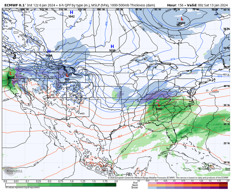
Definitely not the same with the position of the block which the eps has lead the way on and the hgts off The west coast
-

Two Mdt to high impact events NYC subforum; wknd Jan 6-7 Incl OBS, and mid week Jan 9-10 (incl OBS). Total water equiv by 00z/11 general 2", possibly 6" includes snow-ice mainly interior. RVR flood potential increases Jan 10 and beyond. Damaging wind.
Allsnow replied to wdrag's topic in New York City Metro
Now great flakes coming down- 3,610 replies
-
- 2
-

-
- snow
- heavy rain
- (and 5 more)
-

Two Mdt to high impact events NYC subforum; wknd Jan 6-7 Incl OBS, and mid week Jan 9-10 (incl OBS). Total water equiv by 00z/11 general 2", possibly 6" includes snow-ice mainly interior. RVR flood potential increases Jan 10 and beyond. Damaging wind.
Allsnow replied to wdrag's topic in New York City Metro
Grapuel and flakes pouring down- 3,610 replies
-
- 1
-

-
- snow
- heavy rain
- (and 5 more)
-

Jan Medium/Long Range Disco: Winter is coming
Allsnow replied to stormtracker's topic in Mid Atlantic
-

Jan Medium/Long Range Disco: Winter is coming
Allsnow replied to stormtracker's topic in Mid Atlantic
-

Two Mdt to high impact events NYC subforum; wknd Jan 6-7 Incl OBS, and mid week Jan 9-10 (incl OBS). Total water equiv by 00z/11 general 2", possibly 6" includes snow-ice mainly interior. RVR flood potential increases Jan 10 and beyond. Damaging wind.
Allsnow replied to wdrag's topic in New York City Metro
Light snow in Metuchen- 3,610 replies
-
- snow
- heavy rain
- (and 5 more)
-
-
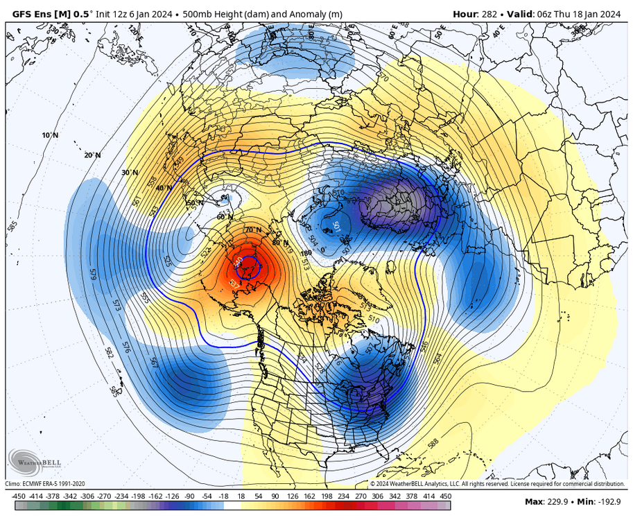
The gefs and geps really look incredible around the 17th . Block moves wests and pops the pna classic look
-
I doubt we see p8 in February if that wave gets so strong in 4-7
-
Looks like we will have two chances 16/17 and around the 20th. The block decaying and p3 giving us a window of opportunity
-

Two Mdt to high impact events NYC subforum; wknd Jan 6-7 Incl OBS, and mid week Jan 9-10 (incl OBS). Total water equiv by 00z/11 general 2", possibly 6" includes snow-ice mainly interior. RVR flood potential increases Jan 10 and beyond. Damaging wind.
Allsnow replied to wdrag's topic in New York City Metro
It’s one of the warmest currently- 3,610 replies
-
- 2
-

-
- snow
- heavy rain
- (and 5 more)
-

Two Mdt to high impact events NYC subforum; wknd Jan 6-7 Incl OBS, and mid week Jan 9-10 (incl OBS). Total water equiv by 00z/11 general 2", possibly 6" includes snow-ice mainly interior. RVR flood potential increases Jan 10 and beyond. Damaging wind.
Allsnow replied to wdrag's topic in New York City Metro
No- 3,610 replies
-
- 1
-

-
- snow
- heavy rain
- (and 5 more)
-
Gefs took another step today towards the eps. Looks like p3 response being enhanced by the decaying block


