

Allsnow
-
Posts
25,895 -
Joined
-
Last visited
Content Type
Profiles
Blogs
Forums
American Weather
Media Demo
Store
Gallery
Posts posted by Allsnow
-
-
-
1 minute ago, psuhoffman said:
Still the 12z AI would be the nightmare lol scenario for those in the same snow hole that’s been the last 8 years. 3 waves go north and one south leaving a comical snow hole over guess where! I think it should at least be a cautionary tale that nothing is in the bag yet.
Gets shoved south because of the TPV sweep. It’s something to watch as it’s still 7-8 days out but it’s not like we haven’t had that issue in the last 8 years
-
9 minutes ago, mitchnick said:
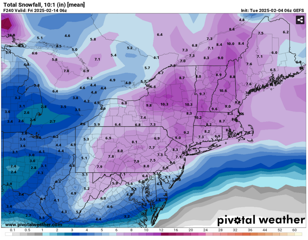
It only goes out to 168hrs. Here's the map.
.thumb.png.d7f751ce84028d95e8b3143f4c9f661f.png)
The AI has me down in the dumps
4 runs in a row pretty far south the latest would have been a hit for this sub forum
-
-
-
-
-
10 minutes ago, EastonSN+ said:
I will be honest, I'm not sure I understand why the look going past President's Day is not a better than average look for snowfall.
The blocking remains, therefore pure cutters should be limited.
Is the problem that the block is too far north?
If anything it seems we are following the same pattern as the last passage through eight one and two, where we had a large snow storm at the start of The blocking period which favored the Mid-Atlantic, which the GFS is currently showing, followed by a wave providing a light to moderate snowfall with a GFS is showing, followed by a trough in the east which the ensembles are showing.
Therefore I would believe past President's Day, obviously not forever but for a week or two, should be at the very least colder than average with the main risk being suppression just like the last passage through eight one and two.
I do think the pattern looks good for after the 15th but between 13th and 16th the h5 look favors a cutter.
-
 1
1
-
-
7 minutes ago, SnoSki14 said:
SE ridge linking with blocking on Euro...same ole song and dance.
My 2-4" by the 20th is looking great
Actually think there's a good window late Feb into 1st week of March. Blocking gets situated and less western troughiness
Cool
-
 1
1
-
-
Just now, Stormlover74 said:
Wow that's early
Agreed. Afd discussion said c-inch but was concerned about frz rain/Thursday commute
-
14 minutes ago, bluewave said:
I agree. The risk with gradients is that we get mixed precipitation events when the systems really amped like the next few. Then if a system is too weak the confluence to the north can be too strong leading to suppression. What we want next week is a goldilocks scenario right in the middle.
Thankfully, the ens continue to look snowy for early next week.
-
-
6 minutes ago, eduggs said:
We don't know what's coming, particularly beyond day 10. Models could be far off with the longwave "pattern" and evolution they are advertising. The EC has one distinct snow threat out at the end of the mid-range. It also has a few minor snow threats before then. GFS and ensembles are similar but with timing differences. Depending on how shortwaves eject from the southwest US and interact with the longwave jet structure, there could be more than one "wave" of precipitation next week.
I'm assuming next week will be our best shot of a big snowstorm this winter. I obviously don't know that for sure, but we can't count of anything past 10 days. Getting a good hit inside 7 days on multiple ensemble means is worth a lot more than mega blocking and fantasy storms 2+ weeks from now.
Next week will make or break the winter imo
The epo is going to pinch off which will probably allow a cutter president day weekend
-
 2
2
-
-
36 minutes ago, Stormlover74 said:
Euro would be alot of frozen Saturday night
2 inch line down to TTN on the eps 24 hour mean
-
3
-
 1
1
-
-
The euro continues to be very warm with very little frozen to start with this system.
-
1
-
 1
1
-
-
Considering the battle between the AO and Se ridge I don’t hate this being south of us in the medium range
-
4
-
-
The primary is getting pretty far nw on most of the models. I just don’t see this as snowy thump outcome but I’ll be happy to be wrong.
I think Saturday night has the best shot for a thump
-
2
-
-
6 minutes ago, eduggs said:
All riding on that one storm next week. Hopefully the guidance is correct
-
2
-
-
Just now, jm1220 said:
Agree, no idea why people at this latitude root them on. You have the rare 2/22/08 or 11/14/18 where the snowy front end actually happens but 5/6 of them or more are crap south of I-84. They’re good for New England and UNY.
I’d prefer this over some torch pattern in February.
-
2
-
-
1 minute ago, forkyfork said:
whenever it's this close i just assume sleet
3k nam is very sleety
I think the better shot for front end snow is Saturday night
-
5 minutes ago, LibertyBell said:
Where has snowman disappeared to?
Idk. I hope everything is okay…
He normally is pretty active for a daily limit poster
-
1
-
-
3 minutes ago, Stormlover74 said:
I agree. Let's get event #1 out of the way first
Agree. To many threads currently
-
1
-
1
-
-
2 hours ago, CoastalWx said:
We patchy
-
2
-
1
-
1
-
-
.png.1fe500f08422d6b29f4bf2e369e87b83.png)


February Medium/Long Range Thread
in Mid Atlantic
Posted
Thank you