wdrag
-
Posts
5,045 -
Joined
-
Last visited
Content Type
Profiles
Blogs
Forums
American Weather
Media Demo
Store
Gallery
Everything posted by wdrag
-
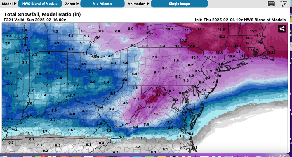
Not title change til half time tonight or 7AM Monday. Probably read "At least some snow accumulation from 3 wintry events Noon Tuesday-9A Wed, 3P Wed-Noon Thu and 3P Sat-7A Mon 2/17". Want to review more guidance for next weekend. I dont prefer the warm inside look of the 12z/9 EPS but it's an option that needs consideration. 12z/9 NAEFS is a little colder with max axis qpf continuing over or south of our area. I think 2" qpf is probable by 12z/17. How much is snow ice rain? We could get our monthly snowfall up within 2" of the entire Feb avg.
-
You all humor me from time to time... thanks for your comment(s). Inexact science, but pretty darn good when you consider the potential for lead time Preparatory information to the public mitigating hazard impact. That's why our road departments are generally on top of the situations and able to minimize disruptions. returning after 4P.
-
Keep looking... posting. OBS thread for the first event will probably be posted Monday evening or at the latest Tuesday morning 7AM. Just in case anyone wonders why the entire next weekend will probably be incorporated into this 3 event thread... the weekend starts on the last day of the currently written thread, and as snow. Since it looks so complicated, I think it best to include the entire weekend (through 12z/Monday the 17th). This particular thread will probably shut down around at 00z/16 when all comments can shift over to the probable weekend OBS thread. Snow blowing now and probably not commenting again til 515P Below what I used for my FB hazard post, covering the 3 coming events. I'll update these late his afternoon. I forgot to highlight the state boundaries but you'll probably click and figure it out.


-
This thread will continue as posted as I responded to complaints and incorporated multiple probable snow accumulators of some sort for NYC, Tue night(2-5), Wednesday evening (1" or less), and Saturday evening-possibly into Monday morning the 17th (large multi hazard event?). This was done to limit threads for clicking back and forth. This particular thread will probably be extended through the 16th or early 17th, in the late afternoon pre Super Bowl update, pending review of the 12z ensembles. This is your week. Have tried to keep this simple but you have to admit to being thrilled with snow action and an unusual train of wintry threats. I'll separate out the OBS threads for each of the next 3 wintry events. Also Next Monday we'll add up the total melted qpf which has a very good chance to be 3" in at least a fairly large portion of our NYC sub forum, between the 6th-16th. Already as of this morning is widespread 0.5-1.2".
-
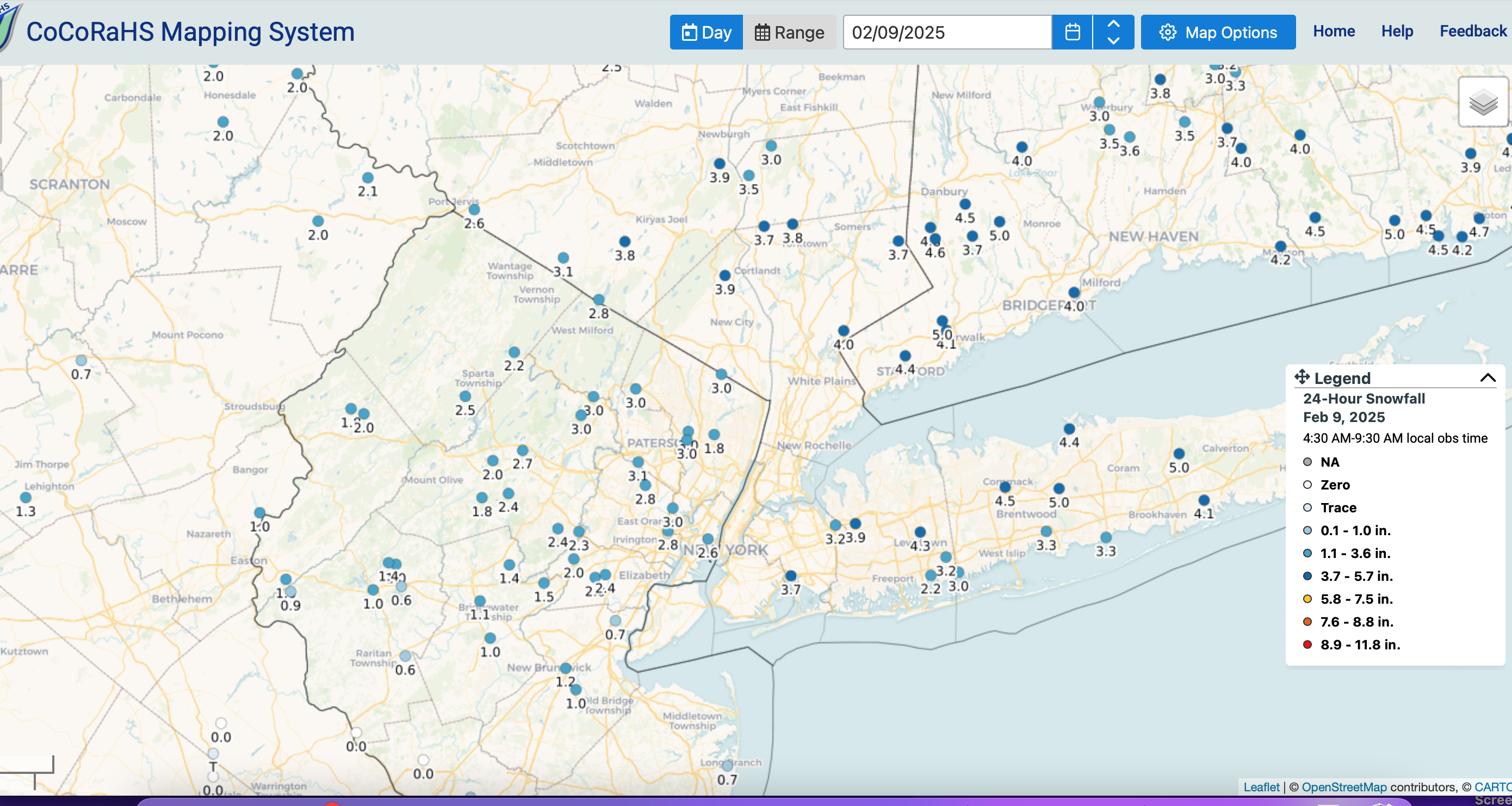
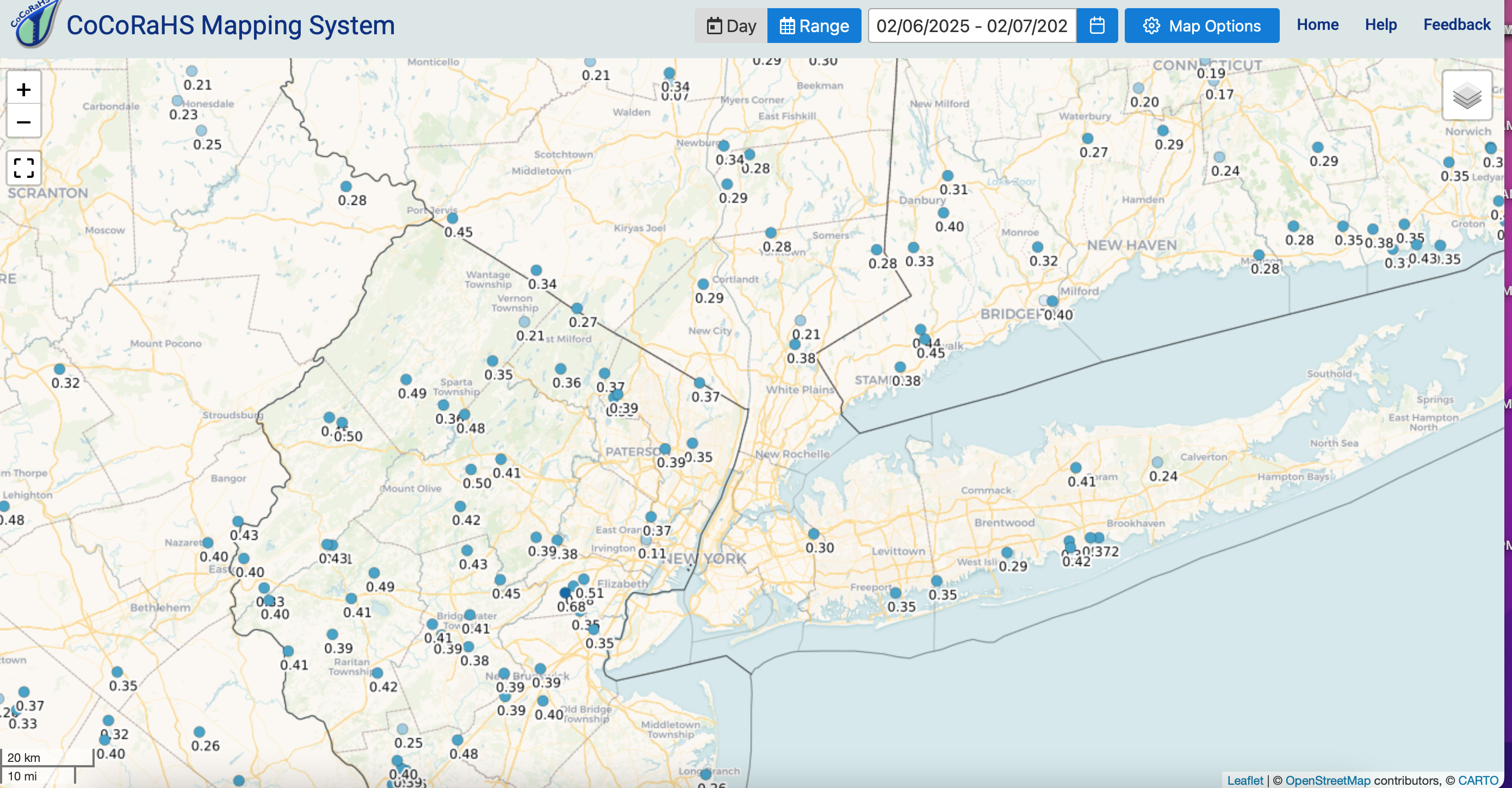
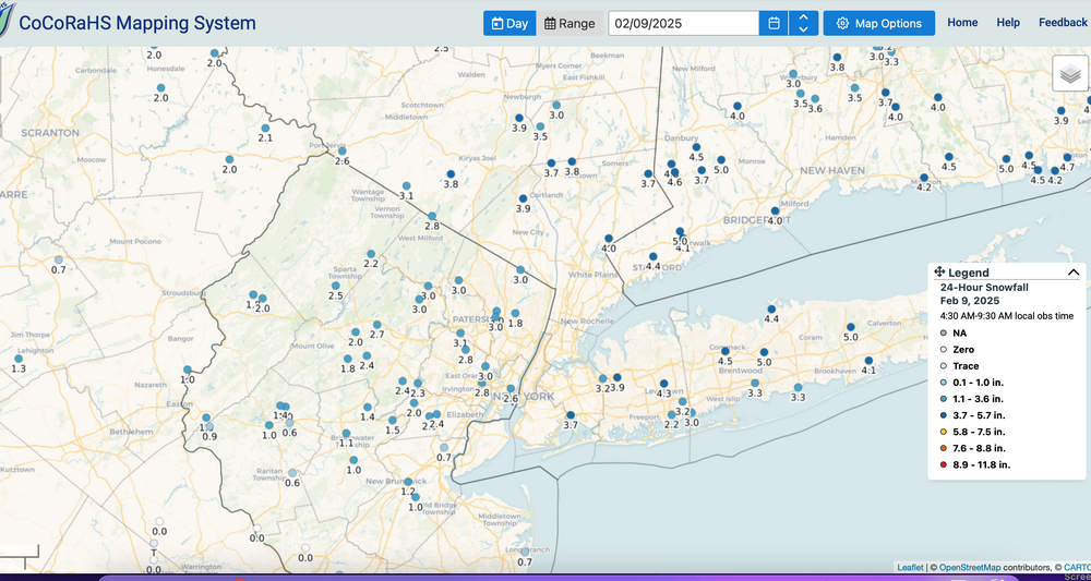
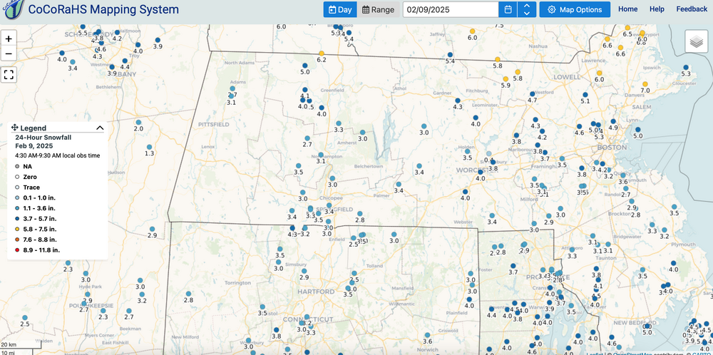
Hope we agree that the NAM and SREF are not always best... certainly not last night. This time the EC-EPS kind of nailed it, Canadian and GFS not too bad either, as opposed to last Thursday when the NAM/SREF prevailed. That is why pronouncements need to be counted in uncertainty. CoCoRaHs for last nights snow attached. Please click for clarity and unless your amount differs by more than 20% from these numbers, please accept this as reasonable.
-
Wantage NJ 4sw. 2.3" of snow-sleet as of 10P. 24F. Began as sleet around 707P, over to snow by 8P and snowed mdt-heavy roughly 830-930P. Will check in the morning with a final. Walt
-
Wantage NJ 1" at 845P... moderate snow. I think the next 1 hr or 2 is our worst. when it lightens up via radar, that should allow the warming aloft to change snow to ice. Once it mixes with ice pellets, I think the main snow show is over.
-
Wantage NJ 0.2" at 8P 25/22.
-
Wantage NJ 0.1" snow-sleet new on the ground as sleet to start has become mostly small flake snow. 28/19.
-
ice pellets to start in Wantage NJ... 29.1F. 707P/8
-
Quite the challenge tonight... how much qpf before an above freezing layer between 725-825MB arrives and turns snow to rain/sleet.freezing rain. There could be quite a gradient of ice to heavy snow between DXR-HPN, POU-MGJ. I should be sleet here at 10PM in Wantage per NAM. IF the HRRR is right... forget the sleet-rain. I'm playing cautious lower end of snow.
-
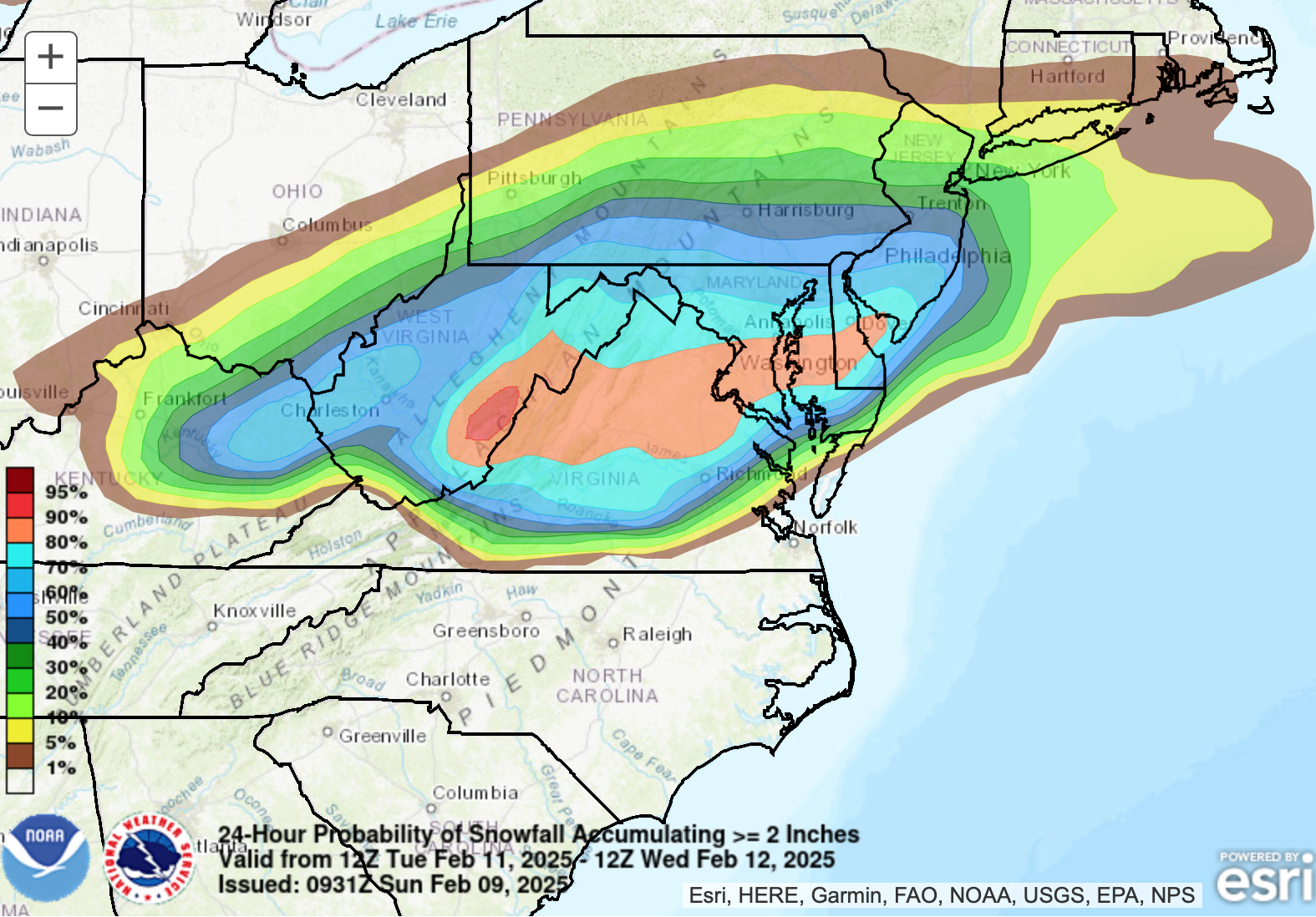
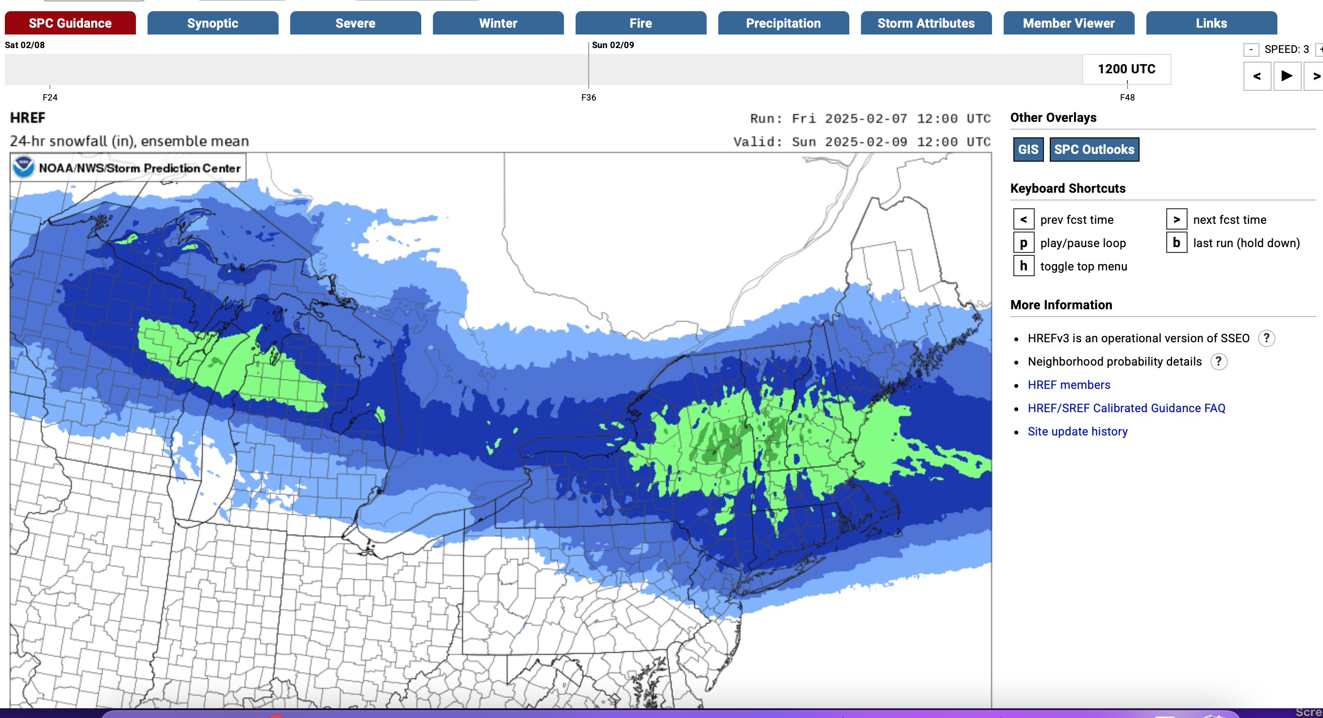
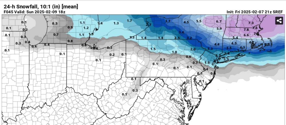
Looking back at p1 starter... yes, as it was written below. I didnt get specific on snow amounts, just pointing out the overall impact and concerns. It takes time (for me) to think these starter threads out (1/2 -1.5 hours), so that they don't overhype, and try to keep a general perspective on the upcoming reality and concerns but also point what I think are modeled expectations, that do not get communicated very well beyond the WWA process in the NWS-WPC, which OVERALL tends to be limited to 60-72 hours. Our HWO's used to permit raising flags well in advance (beyond D3) but no more (to my knowledge). Posted Monday at 07:47 AM This coming weekend Feb 8-9 NORTHEAST USA near and west of I95 through the 184 corridor: Another mixed wintry event with delays and cancellations likely, especially later Saturday into Sunday morning. Timing might be in error as we're 5 days in advance. QPF is ensembled similarly to the 2/5-6 event, somewhere between 1/4-3/4". For now the attached ensembles favor I84 corridor down to the interior of I95 with more risk of rain and melting NYC-LI. The presented ensembles can be in significant max latitude (n/s) axis error 5-6 days in advance of the occurrence. It is a trackable event, in what looks like a train of events for February...some of which can veer off and disappoint but we're at least in the wintry mix game.
-
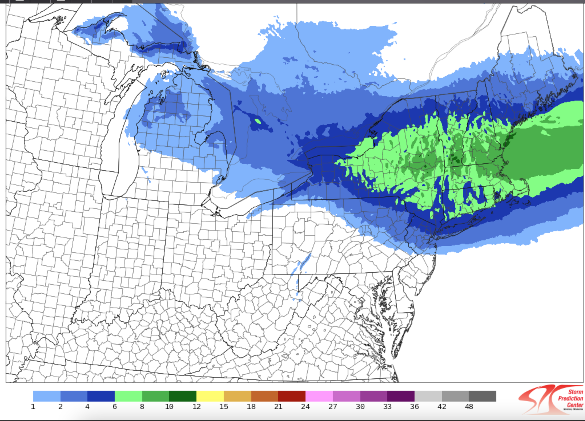
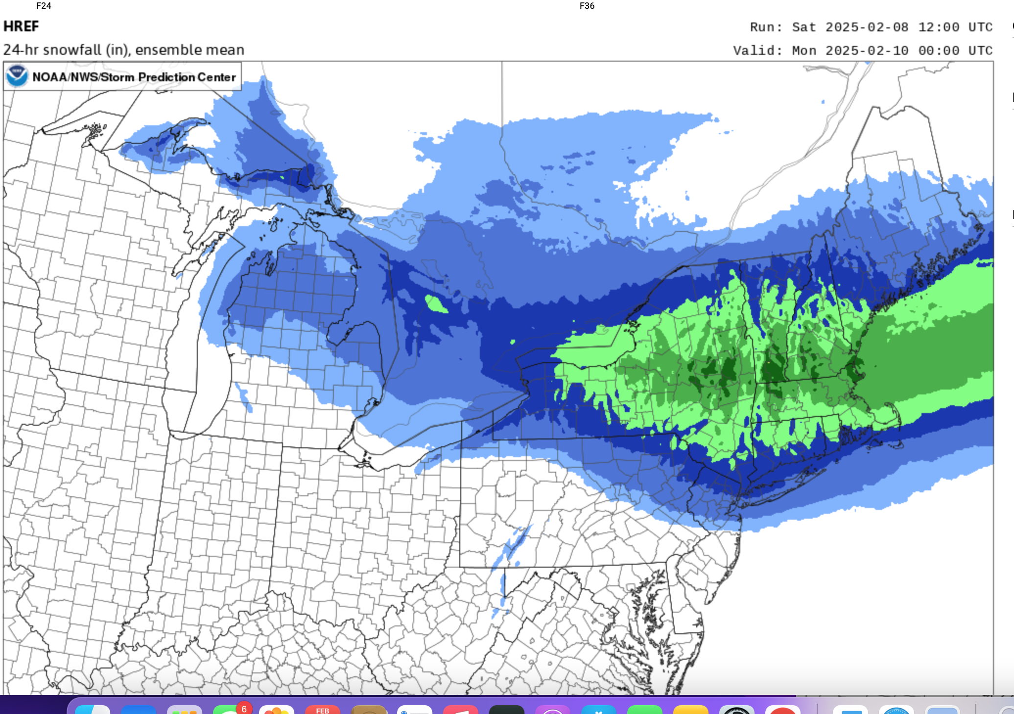
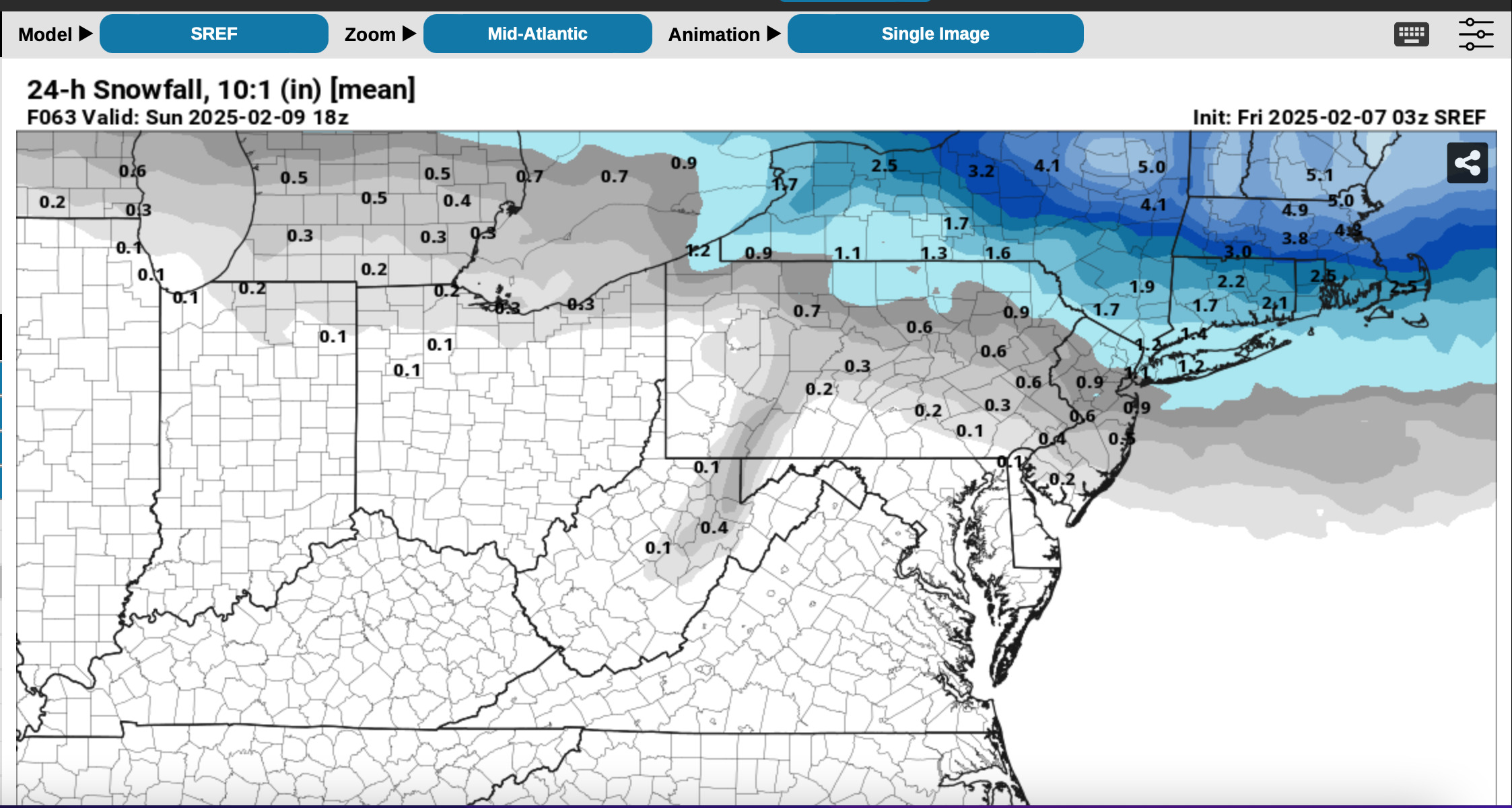
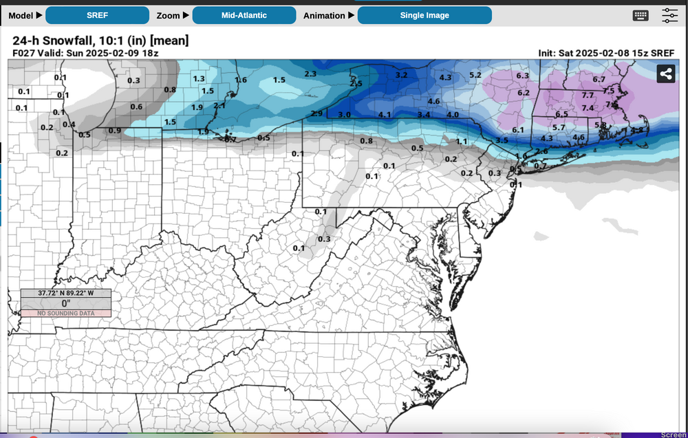
There's a reason why threads are started with ensembles... meant to be a learning tool for those who are interested in some of the NWS processes-considerations. If you go back to p1... WPC had the bigger snow ice threat nw of NYC, the GEFS/EPS seem to be much better limiting snowfall for NYC-LI by 7A Sunday (not a done deal yet). By 11 PM tonight we will know if this the snowier CMCE or the more conservative EPS/GEFS. While I don't count out the beefier 12z snow modeling for NNJ-LI (including the 12z op EC).. I'm counting on the attached SREF and SPC HREF lead time guidance cycles NOT being wrong. The EC you may remember was also doing similarly heavy 12-18 hours in advance for ne NJ on Thursdays storm and it failed. I am leaning NAM... as many of the prior posts have also accepted. What I want everyone to see is what the SPC HREF had in advance, as well as the SREF...available to forecasters yesterday. My eyes water at all the snow these global models offer here... and dont' measure up. Personally I like vertically closed lows to 500MB passing east or ne off the DE/s NJ coast toward the benchmark and enough cold air to support the snow here. I tried to get these up sequentially but not easy. Just click on anything that is partially showing. The conservative approach is there. Attached


-
This thread continues as originated. LOTS of wintry mix events coming. It's possible that I'll extend the thread through the 16th in the middle of next week depending on modeling. Next weekend is looking like a 1-2" qpf event with rain-(freezing rain depending on temp reality inland of I95) all preceded by some snow-sleet Saturday afternoon-evening. View it as you wish, but keep blending and not using one cycle as trend, plus use the SREF/NAM warm nose inside of 36 hours to trim potential. I'll check in late today (but off line 9A-1P)
-
Moderators: Probably good to pin 2/11-15. I wont be thinking about 2/16-17 or anything beyond, until we get to Valentines Day and see what has happened between 2/8 and Valentines Day morning. There's enough track the next week or so. Hope everyone I84 corridor has plenty of snowblower gas and from what I can tell, looks like NYC-LI may need some of that as well. Anything 2/16 and later should stay right here in the Feb thread, until we can get through much of next week.
-
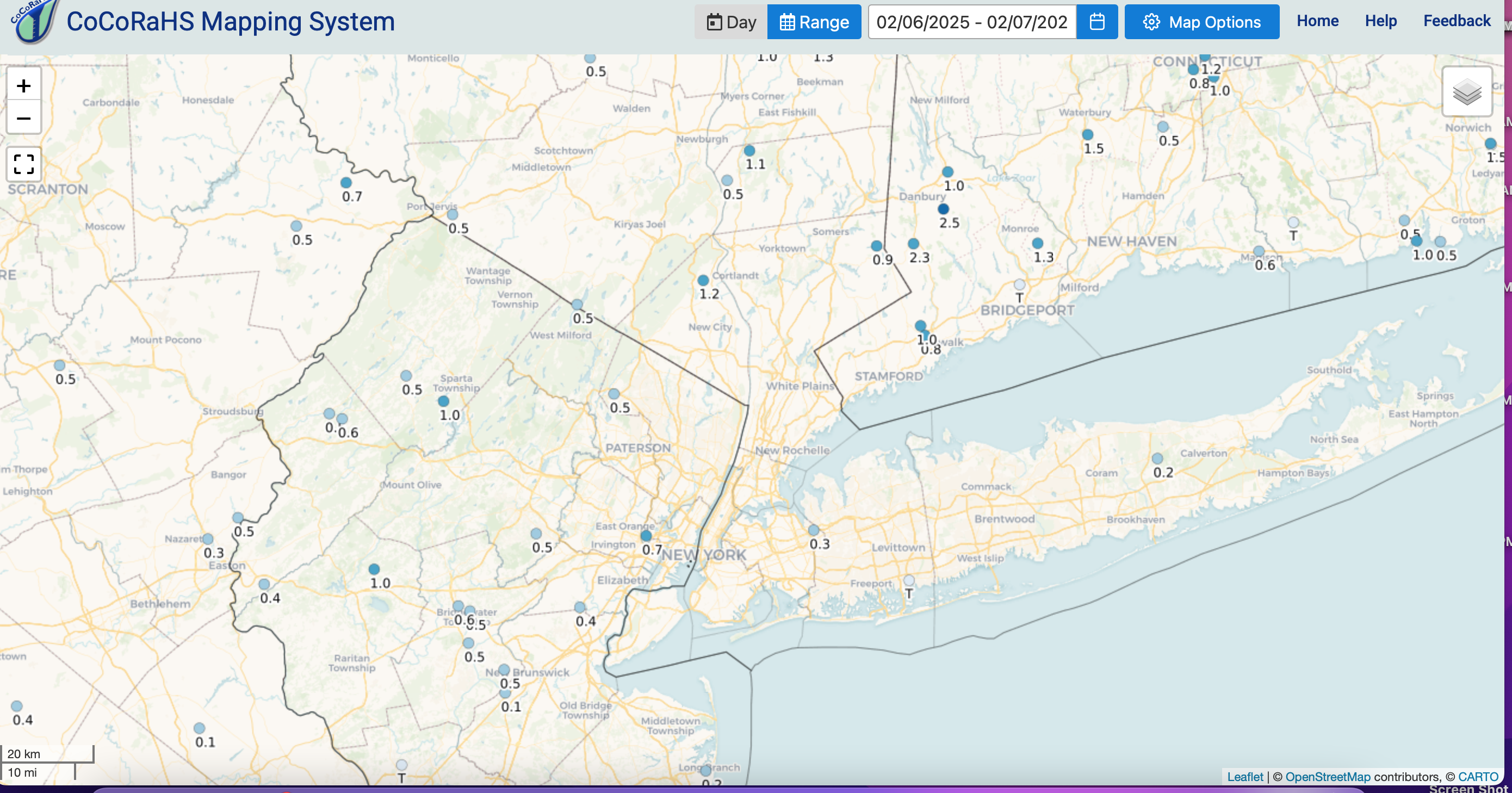
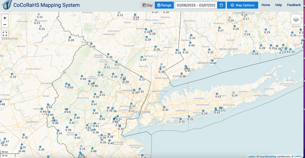
To supplement the above... CoCoRaHs as of 8AM Fri 2/7. The event yesterday basically 4A-9A in our area for snow-sleet. Lesson learned if anything, warm nose compromises snowfall and NAM will probably have the best idea, especially closer to T0. Sleet instead of snow still made this a widespread hazard, even parts of NYC-Li, though shorter duration there compared to inland. My last on this thread. Thanks for all the supporting posts. Continue on now for 2/8-9, 2/11-15.

-
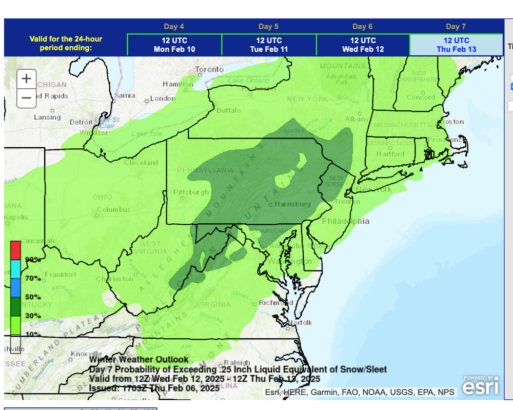
Thread is started for the 11th-15th. Migrate over when you can. OBS thread for the events next week will post a few hours before each event (as needed). I think NYC should do okay (4+" that entire 5 day period but NOT a guarantee). Am offline overnight.
-
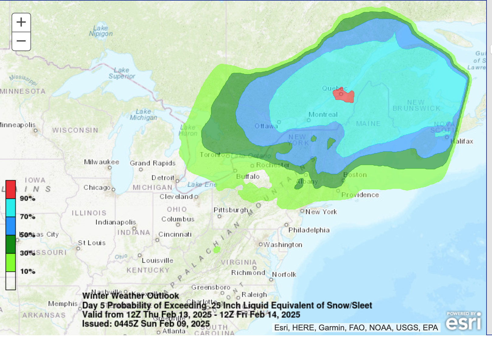
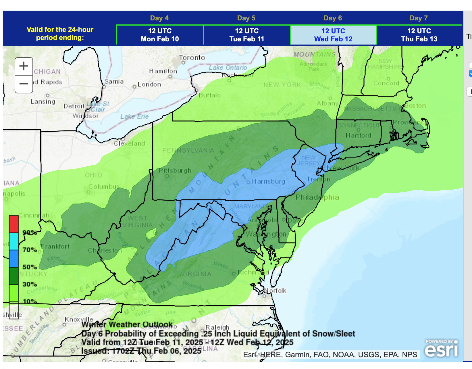
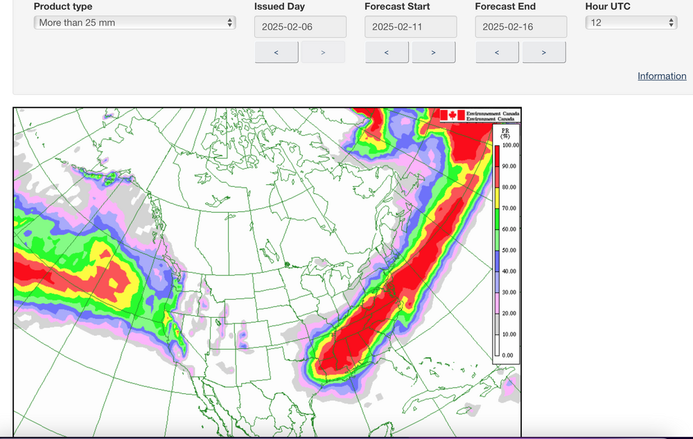
To illustrate my concern about suppression due the NAEFS averaged jet core so close to our area... here is the NAEFS chance of 1" qpf in this 5 day period... notice the max axis is south of us and our prob for an inch in NYC is about 50-60%, according to this CMCE-GEFS blend from the 12z cycle.
-
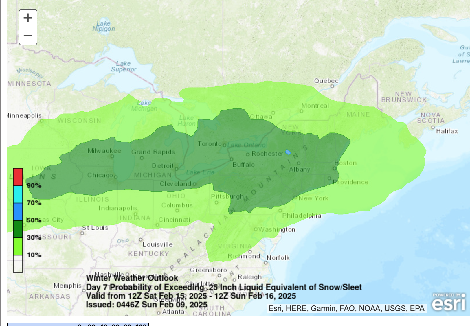
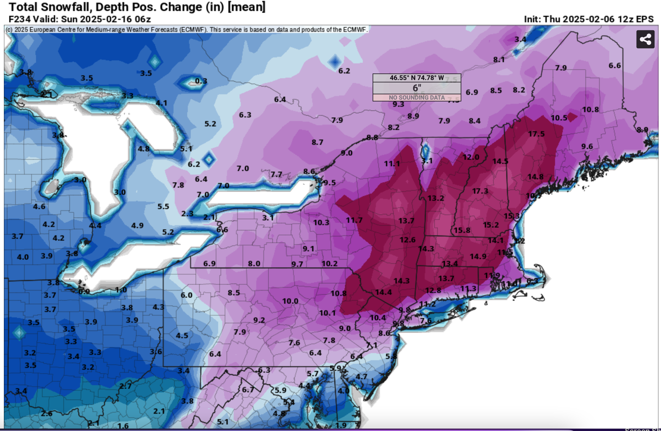
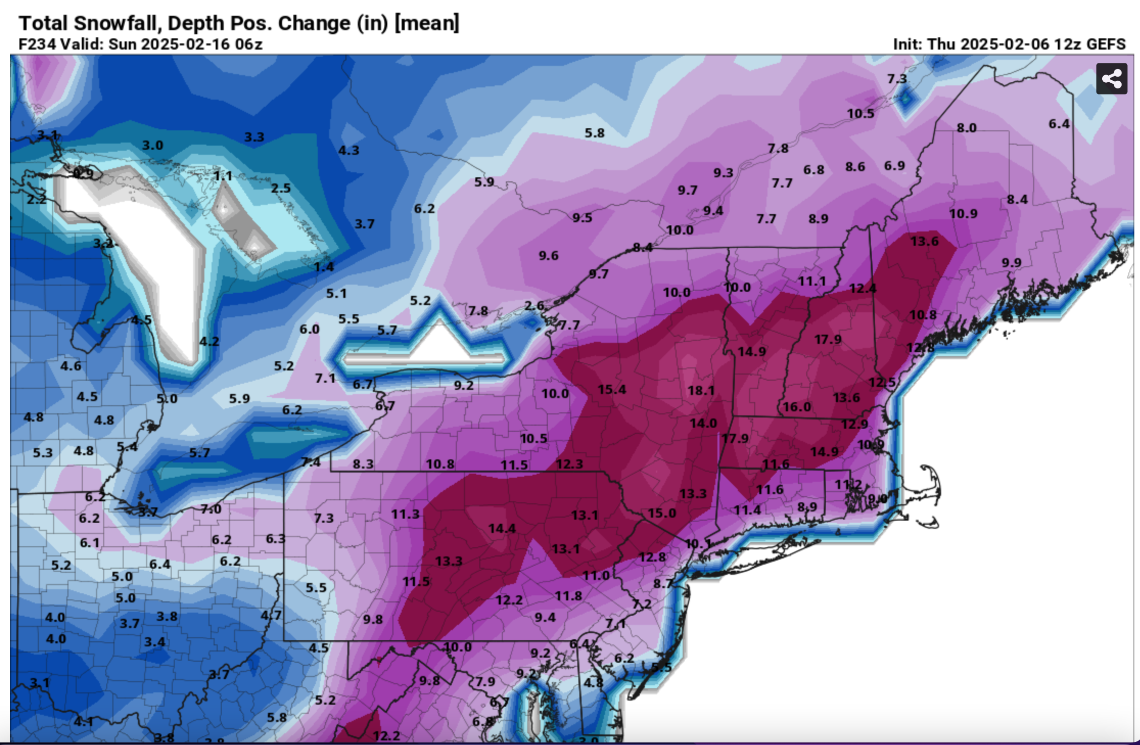
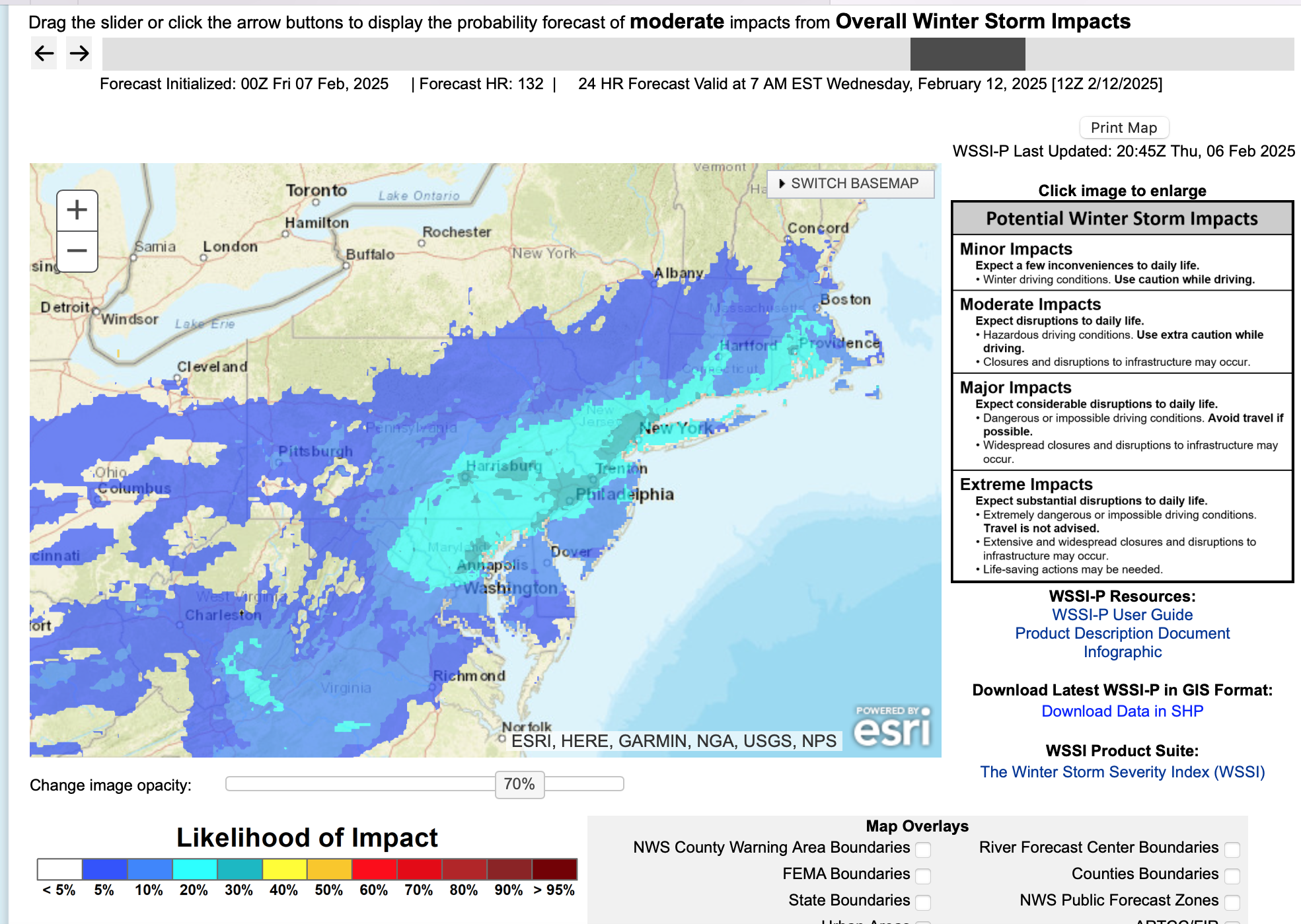
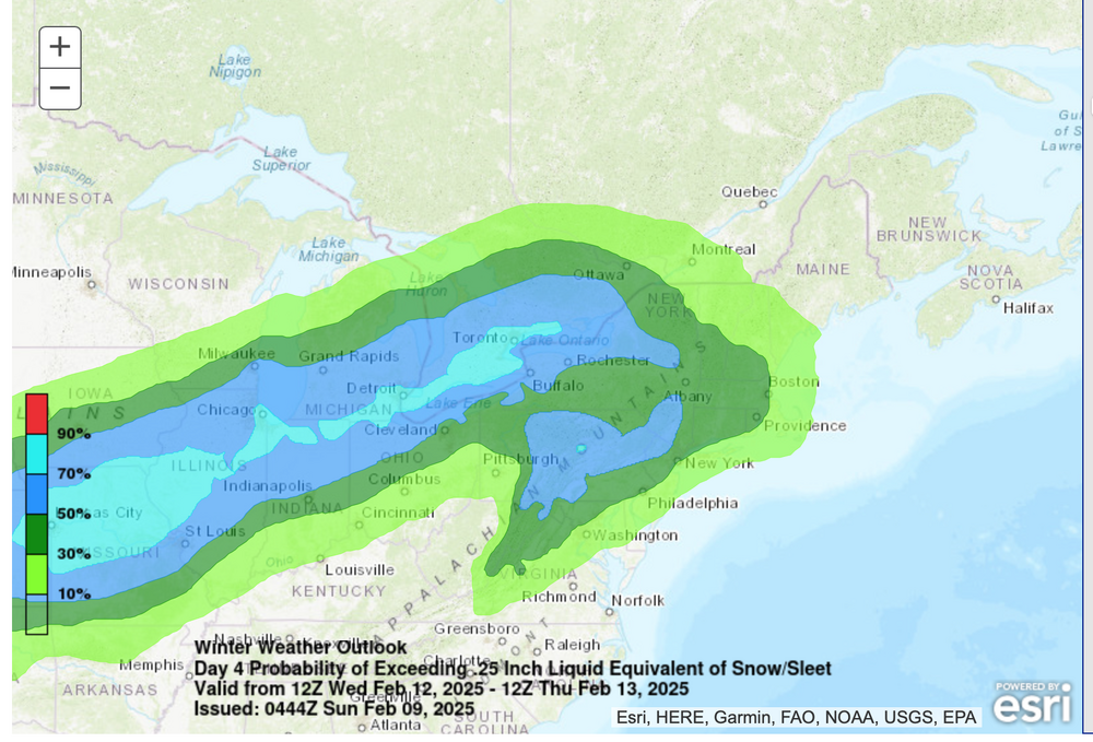
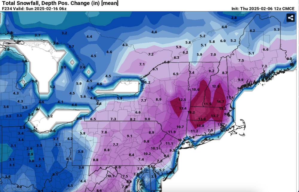
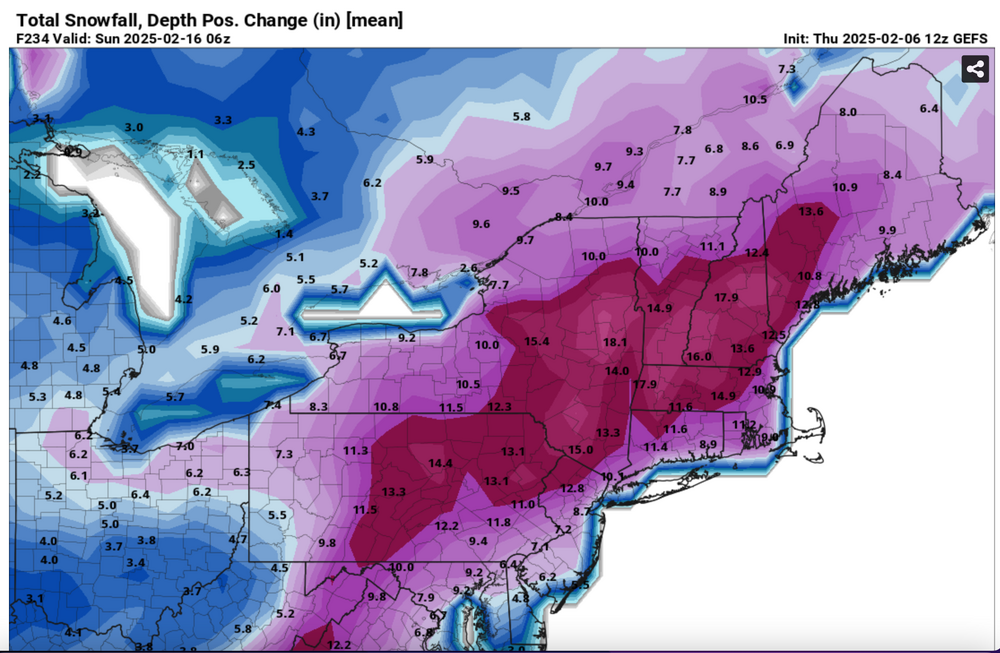
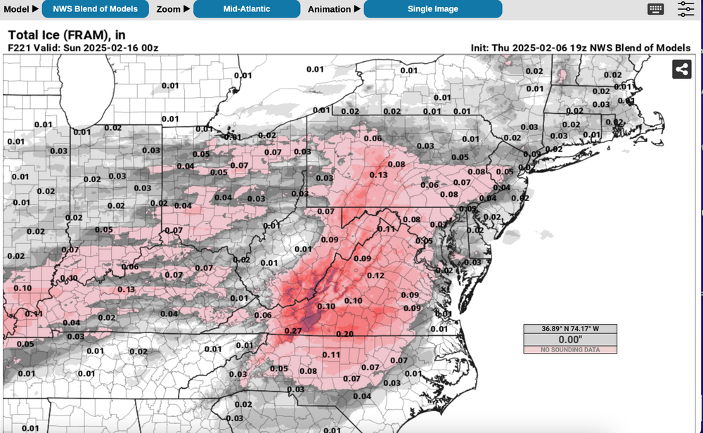
Best chance for a total of 6+" inland with NYC-LI-coasts? Ensembles are added. All graphics should self identify. Ensemble snowfall is the more conservative positive snow depth change and prefer to minimize overhyping despite a decent looking pattern. It and the NWS Blend of Models snowfall does include some snow from this weekend, but the bulk is with in the Feb 11-15 period. One thing I dont like about the BOM is that it has averaged snowfall across all of LI instead of adjusted toward the ensembles. The BOM may be right if two of these decent events are all snow for LI. Included also is the Blend of Models somewhat realistic expectation of a little freezing rain, probably better than the EPS. The WPC 6-7 outlooks are attached and finally the conservative WSSI-P which implies an I95 modest snowstorm (low probs moderate in this example for D6) Generally cold high pressure should extend from the Canadian Rockies across southern Canada in this period with an average 150KT 200MB jet core persistently centered near Boston. That places the NYC subforum on the edge of the RRQ of the upper level jet, rather close to the core, so that in my opinion, some southward suppression might occur in the surface pattern during this time frame or the NAEFS (multi ensemble inclusive of the CMCE-GEFS) might change as the models change over the next week. Ensemble guidance basically is producing 1+" of qpf for our area in this time frame. All yours! 713P/6


-
Good afternoon all, The new thread (2/11-15) that will incorporate two, possibly 3 events and will post between 730-8P. A few of the graphics are ready but I want to steady myself with further checks and AI, all after I walk the dog and have dinner-a little tube time with my better half who tolerates my interest in wintry hazards. This coming thread should satisfy next weeks 2 or 3 chances, and I see there are others later on. It's sloppy up here, max T 33, 0.6 sleet this morning. I'll add a summary post to the 2/6 event tomorrow morning at 915AM in that thread.
-
https://www.weather.gov/source/crh/lsrmap.html?sid=lot Move the map to your area of interest... The above link (in case you dont have it)... change it to whatever hours check you want... today I'd cut it back to 12 hour reports. Then hover your cursor over all the reports. You got ice and you sleet and snow accums. They also show up on the right side, nice to have when you zoom to your area.
-
Isn't Rockland or is Wedstchester, home of snowman? I guess I could mistaken. Any clarifications?
-
I think. ut not absolutely sure, a light rain after days of none... road oils not washed away but wet.... a bit more slippery. PATCHY dense fog, in other words highly variable traveling vsby is a problem cause drivers are not quite as cautious and they can quickly lose situational awareness.
-
Summary on this late today or tomorrow will affirm the NAM overall was best on warm nose, and the widespread 0.2-0.8"sleet that occurred this morning. Frequently it is best on this. The problem, if its too warm, suddenly you are plowing 2" instead of sliding on 1/2" of ice pellets. My previous post kind of shows that the heavier modeling missed by a degree or 2 in the mid levels.