wdrag
-
Posts
5,045 -
Joined
-
Last visited
Content Type
Profiles
Blogs
Forums
American Weather
Media Demo
Store
Gallery
Everything posted by wdrag
-
I reference CP in most of my posts... that's the heart of the city representing I think much of LI. If it goes good there, it usually, correct me if I'm wrong, it usually is pretty good for most of metro NY and northern LI.
-
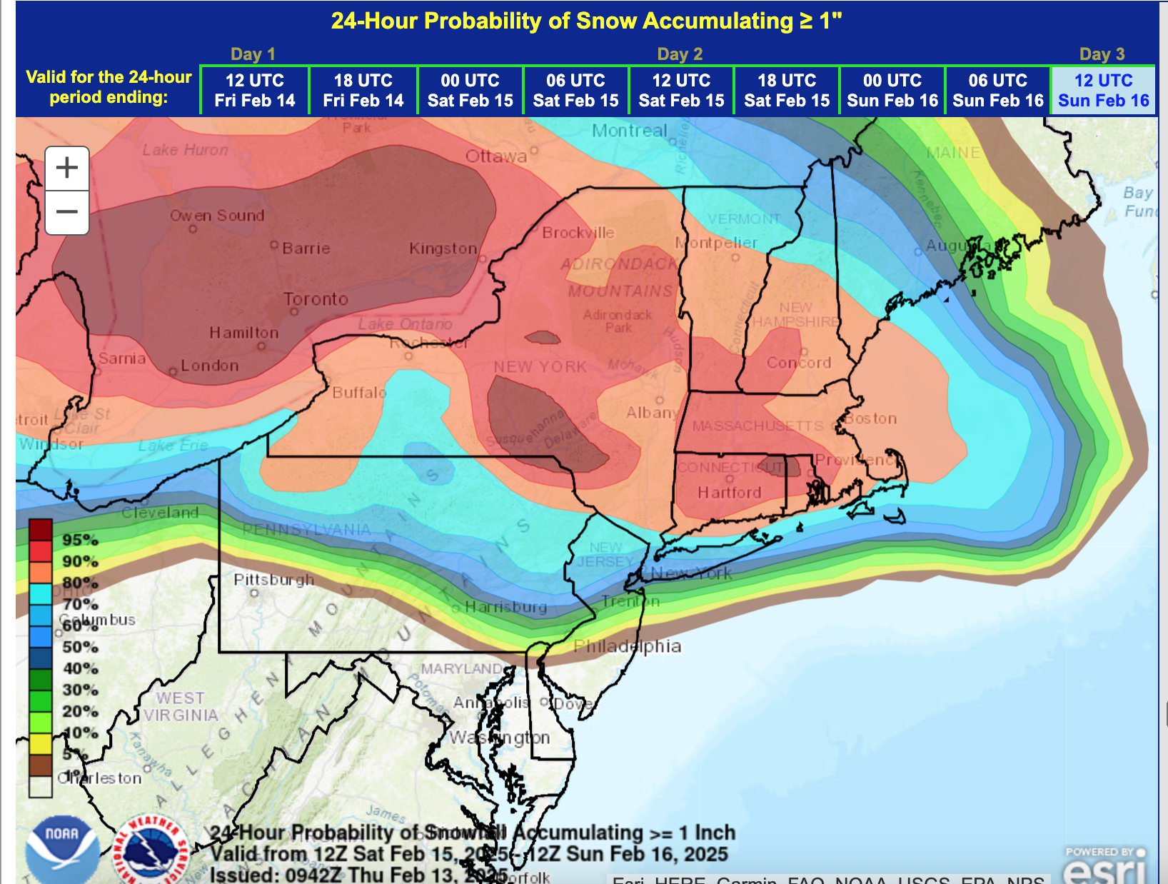
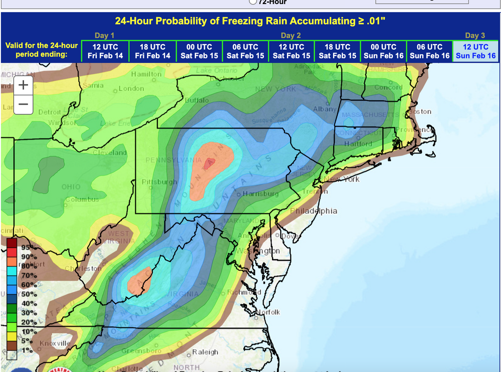
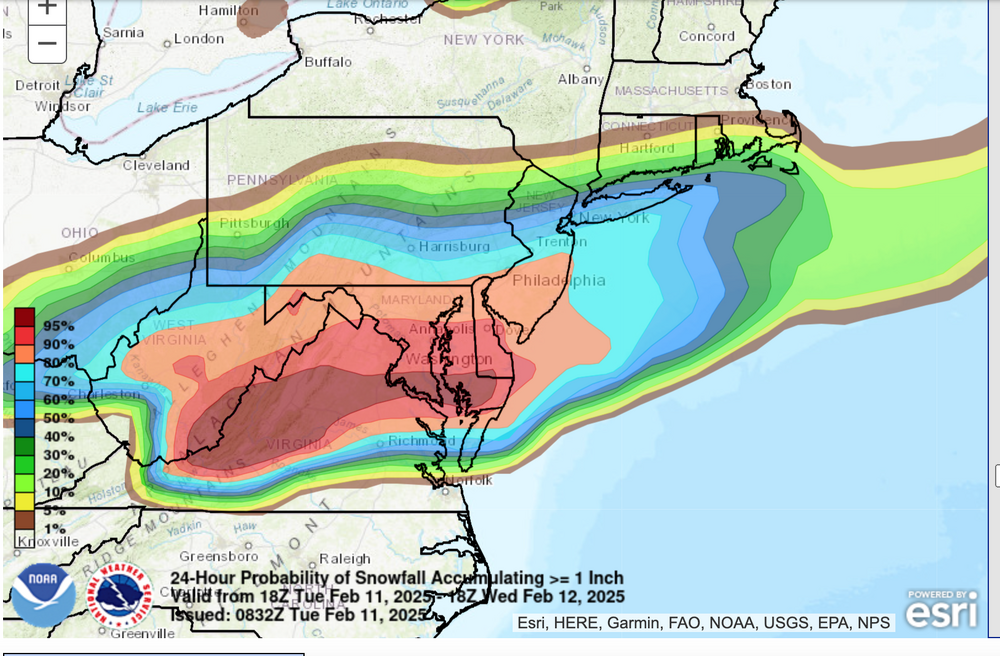
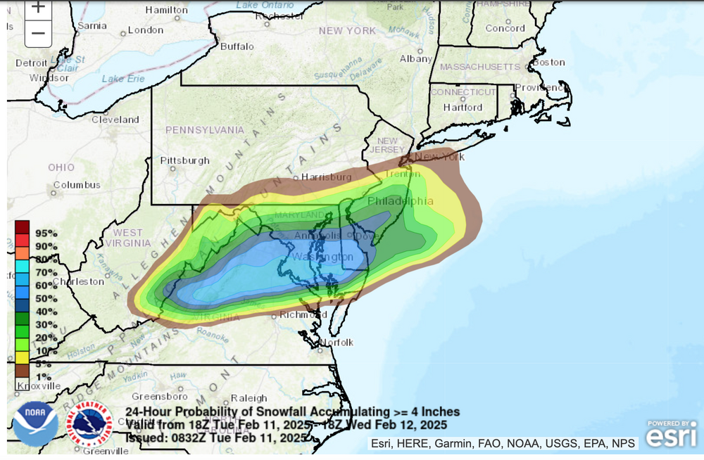
Not sure what you're reading but that's a 60%. chance for 1" NYC CP... even icing near NYC. Probably a pretty decent from end snow, the temps unlikely to get out of the upper 30s-lower 40s NYC on Sunday and potentially serious ice storm I84 hilly terrain with some damage. My concern is the gusty winds for the I84 corridor behind the storm Sunday night-Monday morning taking down ice laden limbs (snow laden well north of I84). OBS thread for Saturday event will probably post at 7AM Saturday. I may run it as an OBS thread for the front end wintry and then tack on wind damage for Sun night-Monday, and whatever Feb melted water equivalent totals you have for Feb at that time (through the 16th) in that thread.
-
Not threading the20th yet but will recheck guidance af 5PM. Ensembles all have some snow, possibly. a snow storm.? Just too soon with the various possibilities but I'm planning on some snow acc for the NYC subforum. Also before that... might need an OBS thread for 50-60MPH winds gusts midday Monday but too soon to know if any wind past 50.
-
Ensemble chance of 1+" of snow Saturday Noon-8PM, and the conservative ensemble chance of icing Saturday night. This situation is complex but looks dangerous to me for parts of the hilly areas of I84 where temps are going to struggle to rise above freezing this weekend. In the meantime, I think CP has a good chance of 1" of snow-sleet Saturday afternoon-evening, maybe even 2" if lucky. Now we're within 4" of the Feb normal at CP. All smalls but nice nonetheless.

-
OBS-Nowcast for snow 4P Tue 2/11-7A THURSDAY 2/13/25 Mainly NJ-NYC-LI.
wdrag replied to wdrag's topic in New York City Metro
Exceedingly minor but CP did add another 0.1" last evening... monthly total now 6.2, within 4" of Feb normal. Not bad for the first 12 days. -
OBS-Nowcast for snow 4P Tue 2/11-7A THURSDAY 2/13/25 Mainly NJ-NYC-LI.
wdrag replied to wdrag's topic in New York City Metro
Wantage NJ: 0.2" snow-sleet yesterday 3P-mid, now a pretty heavy freezing drizzle. Salting roads just now. 30.7F glaze a few hundredths thick, estimating less than one tenth inch at 424AM/13 -
OBS-Nowcast for snow 4P Tue 2/11-7A THURSDAY 2/13/25 Mainly NJ-NYC-LI.
wdrag replied to wdrag's topic in New York City Metro
yes, per 4PM OKXCLIJFK -
NO new thread for a wintry event 2/19-22 til late Thursday - 2/13 at the earliest or until ensembles come together again. Too chancy on a miss
-
OBS-Nowcast for snow 4P Tue 2/11-7A THURSDAY 2/13/25 Mainly NJ-NYC-LI.
wdrag replied to wdrag's topic in New York City Metro
Wantage NJ 0.1" snow-snow pellets 3P-430P. 28/23 at 5P. -
OBS-Nowcast for snow 4P Tue 2/11-7A THURSDAY 2/13/25 Mainly NJ-NYC-LI.
wdrag replied to wdrag's topic in New York City Metro
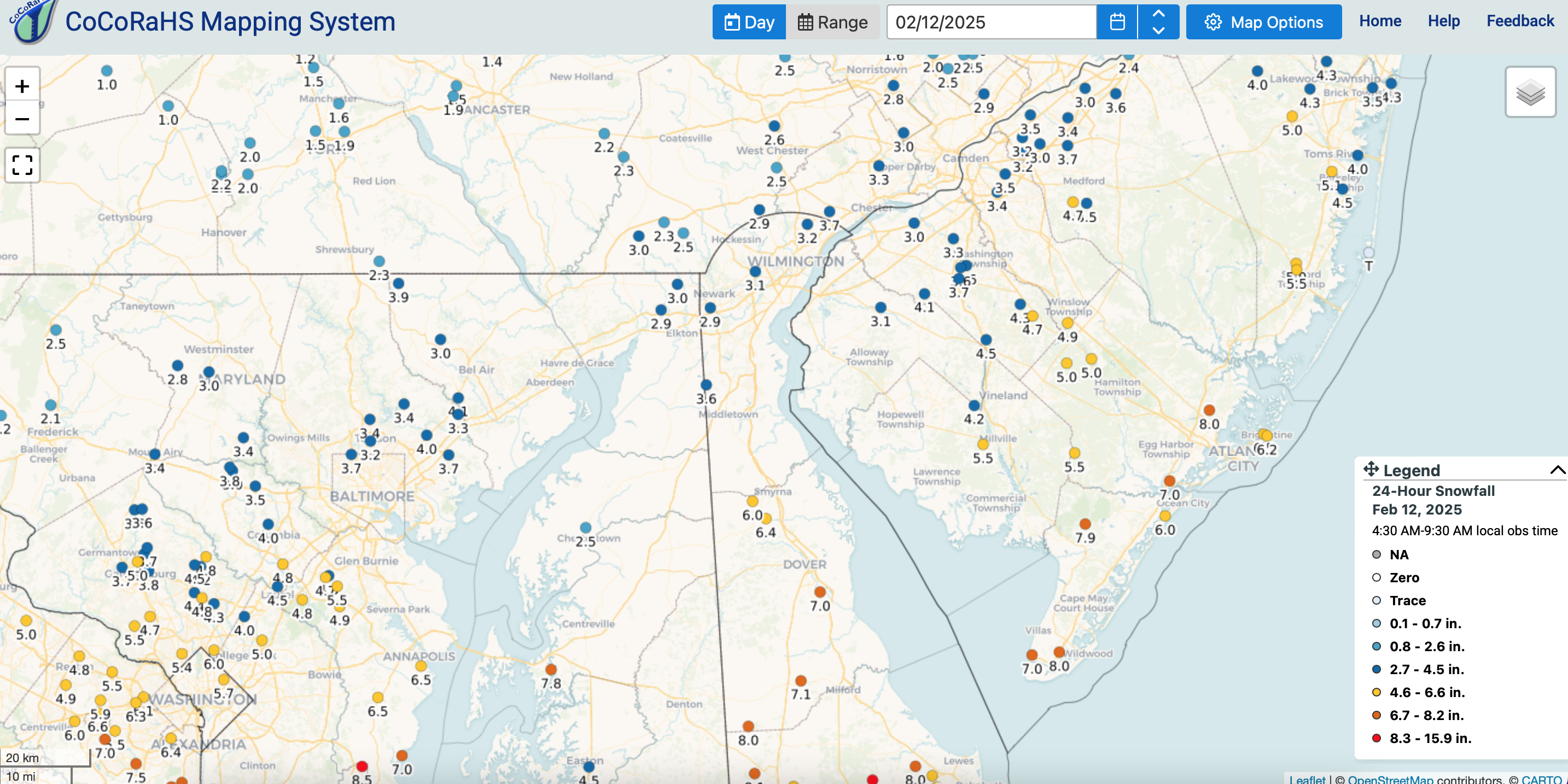
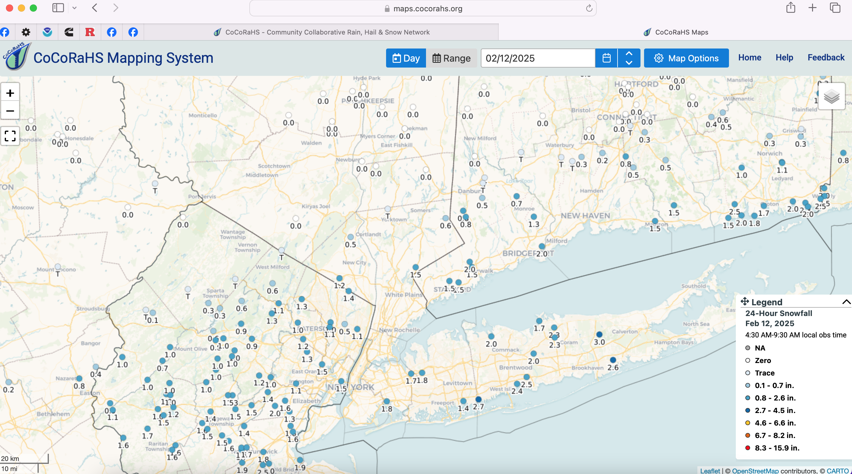
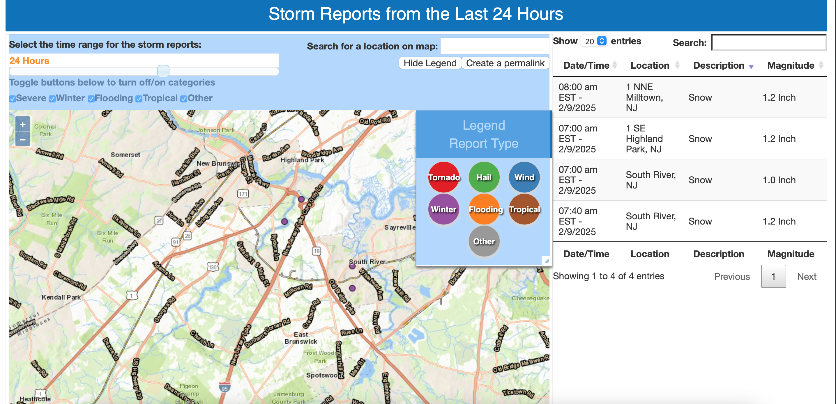
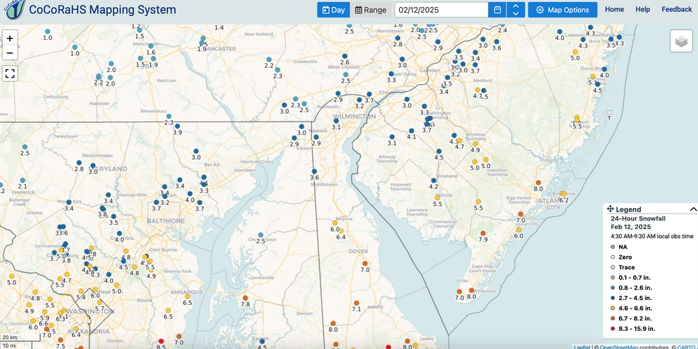
Finals through 7A: 2/12/25 CP, LGA, EWR 1.5, JFK 1.8 ISP 1.9 DCA 6.4 BWI 3.8 PHL 3.1 ILG 3.4 ABE 1.0 ACY 7.8 -
Am not doing anything for 19th-22nd until 6P today at the earliest... reasoning: I dont want to dump a thread on the subforum that ends up less than 1" CP. I see at least 2"+ for CP next week, but a little concerned about inside runner, since the strength of the short waves is in the northern branch (Great Lakes) which means we need redevelopers off DE and not convinced we can dig these troughs far enough south. Just want another ensemble view.
-
OBS-Nowcast for snow 4P Tue 2/11-7A THURSDAY 2/13/25 Mainly NJ-NYC-LI.
wdrag replied to wdrag's topic in New York City Metro
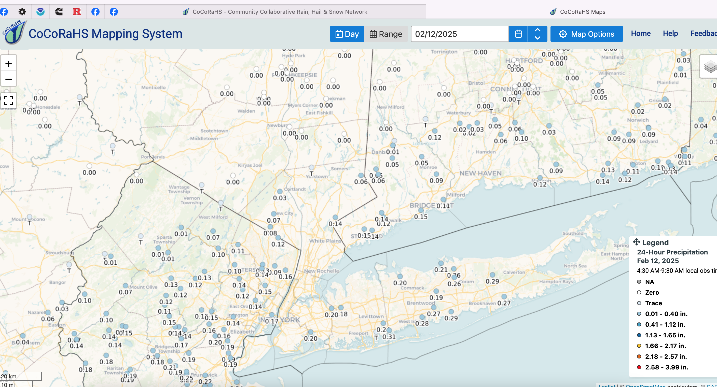
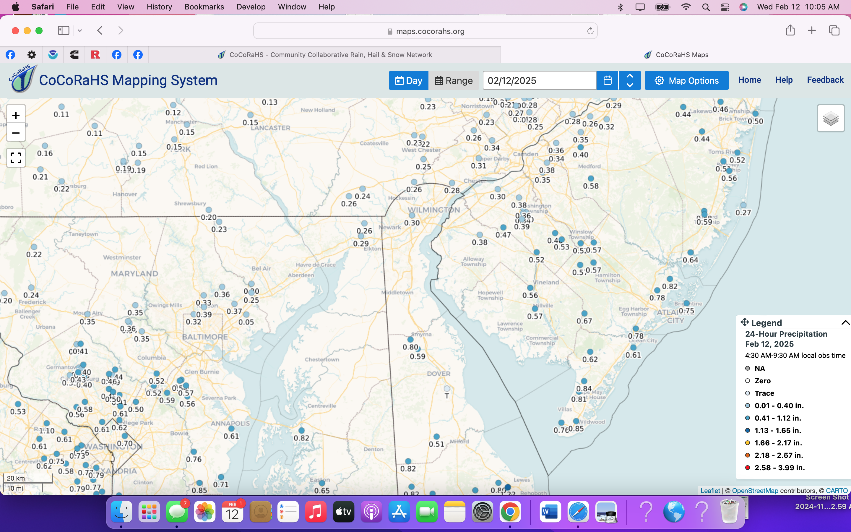
Adding CoCoRaHs for this event, including qpf. Supplement ag will with prettier analysis and actual NWS PNS. Have a day-glad to see some appreciation for this winter. More coming the next 10 days including snowfall for CP as we try to get to our Feb normal of 10.1" Haven't checked on how much actually fell in this event through 7A for CP, PHL, BWI,DCA.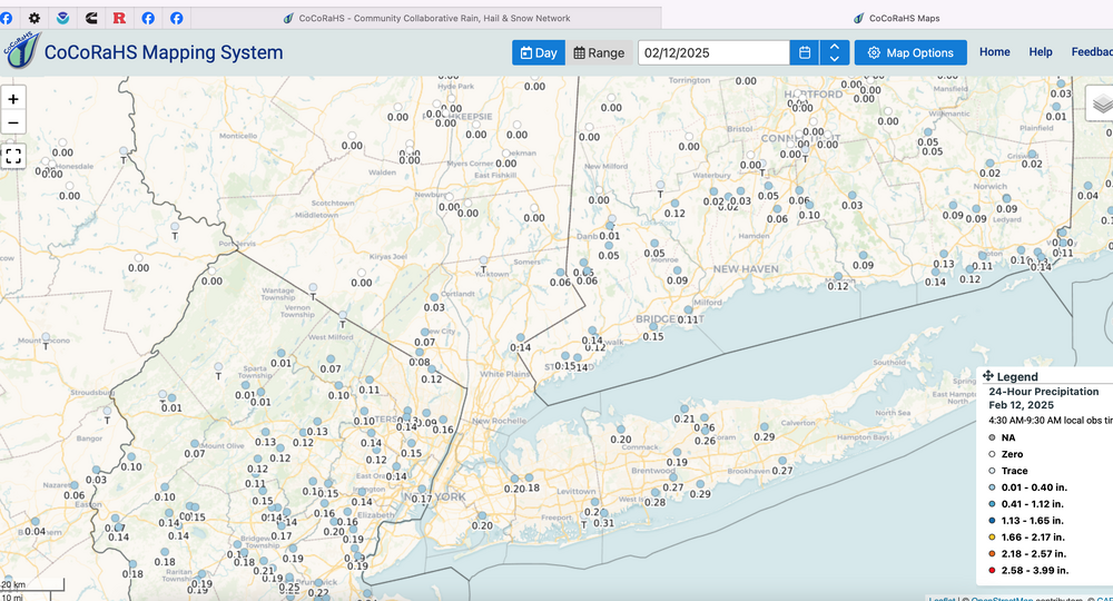


-
OBS-Nowcast for snow 4P Tue 2/11-7A THURSDAY 2/13/25 Mainly NJ-NYC-LI.
wdrag replied to wdrag's topic in New York City Metro
Commack, Sayville reports among others at 3". -
OBS-Nowcast for snow 4P Tue 2/11-7A THURSDAY 2/13/25 Mainly NJ-NYC-LI.
wdrag replied to wdrag's topic in New York City Metro
I'll get a CoCoRaHs map up at 930AM which will be supplemented by other reports gathered by our group. -
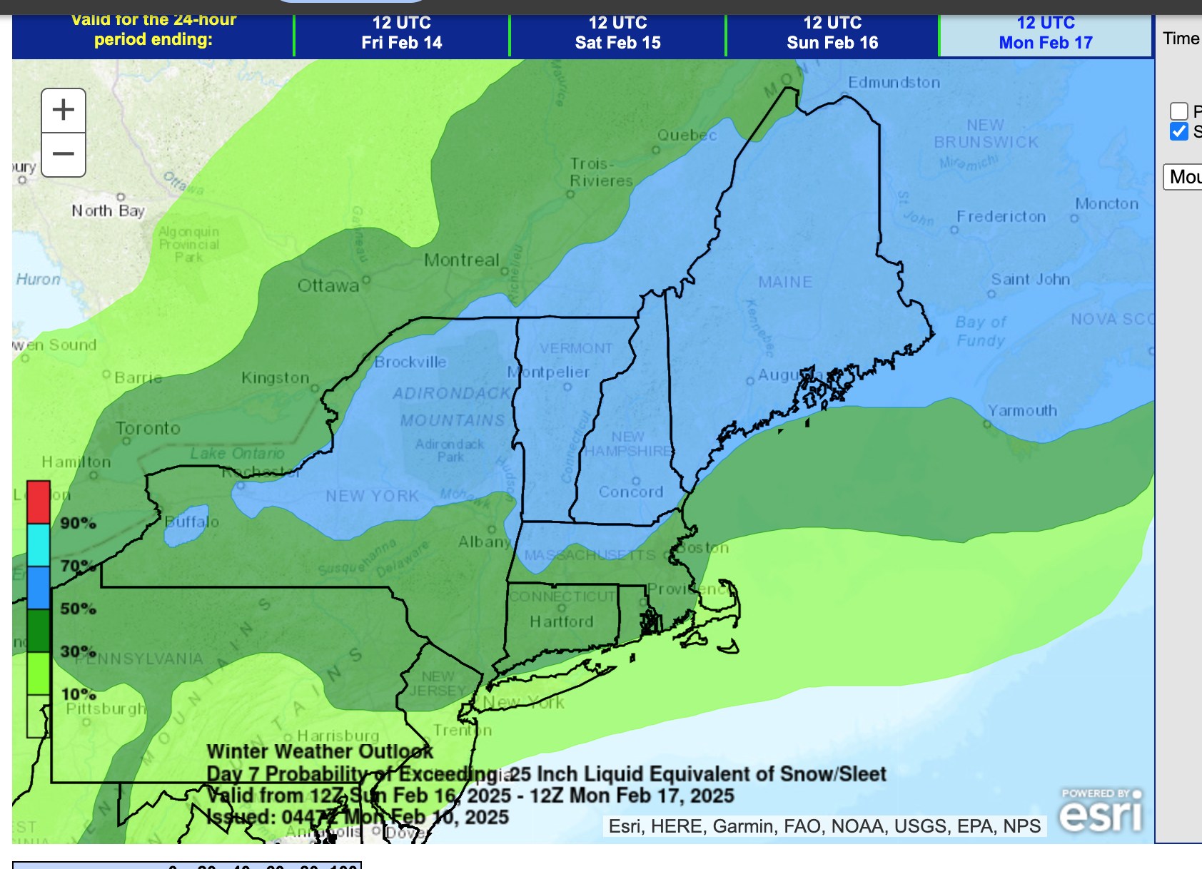
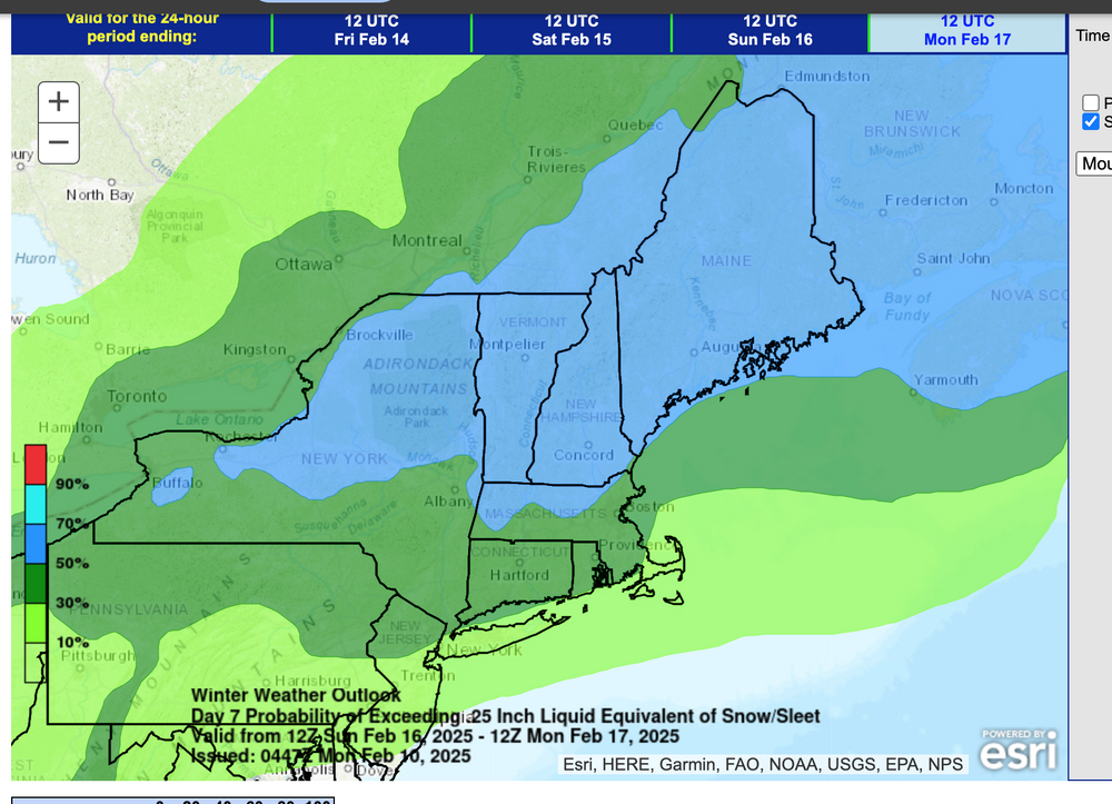
Havent followed the Feb thread closely recently, but regarding Sat... please see attached. I saw only the posts this page and their snowy interest for Saturday afternoon is also mine. The plan is to start a tracking thread at Noon for an I95 snowstorm/event Feb 19-20, (maybe better than what just occurred). ALL 00z/12 Global Ensembles that we normally use, continue recent days suggestions. The idea as to get us over the Central Park 10.1" normal February snowfall... I think we're on our way. Finally: I think we have at least a wind advisory event Sunday night-Monday for much of the eastern USA, a period of 45-55 MPH gusts.
-
OBS-Nowcast for snow 4P Tue 2/11-7A THURSDAY 2/13/25 Mainly NJ-NYC-LI.
wdrag replied to wdrag's topic in New York City Metro
Wantage NJ in far northern Sussex County... just had a few flurries-T, so far. I think we get some later this morning-evening. At 410AM have extended the headline into the second event since this reduces thread bounce, AND, I think that "parts" of our NYC subforum including LI, NJ, PA will see an additional few tenths of an inch of snow today with ice pellet very minor amounts this evening, and of course the obligatory icing well inland overnight. Don't be surprised at a little drizzle-freezing drizzle for LI and the NJ coast today. The additional snow may not stick very well during the daylight hours as temps rise. Still suggest cleaning the snowboard AT MOST once every 6 hours and see what you get. Thank you for all your shares. I am considering starting a separate 19th-20th snow storm-event thread late this morning. -
OBS-Nowcast for snow 4P Tue 2/11-7A THURSDAY 2/13/25 Mainly NJ-NYC-LI.
wdrag replied to wdrag's topic in New York City Metro
Over 6.5" in ACY per PHI CLI. -
OBS thread for Wed Noon-8A Thu wont issue (if needed) until late Wed morning, again if needed. Will rearview overnight. No extension of the current thread planned at this time, but monitoring if the weekend system trends sewd 100 miles. For now buying into the GFS/GGEM 12z/11 cycle without as yet a review of the 12z/11 EC.
-
Looking at the weekend... complex. Looks cold and icy inland-especially I84- after a bit of snow Sat aft-eve.
-
OBS thread for tonights event has been started... 4PM ish start time for the southern areas. Am expecting at least one more snow-sleet accumulator event, probably Sat aft-eve. Tomorrow night looks wet, possibly with a little sleet/dash of snow ice start NYC?
-
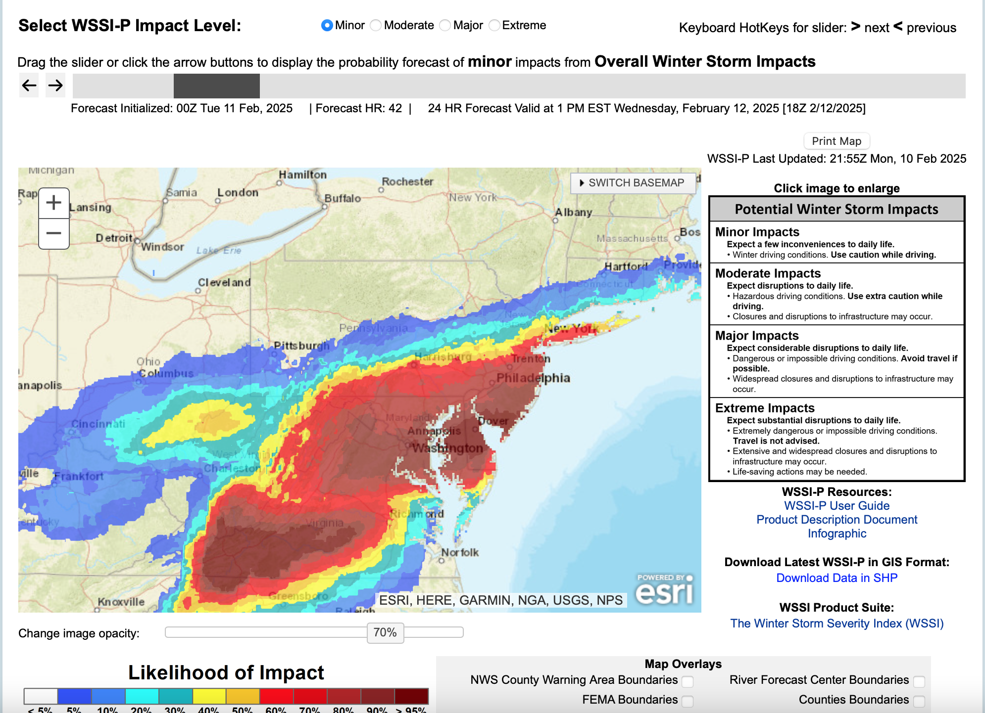
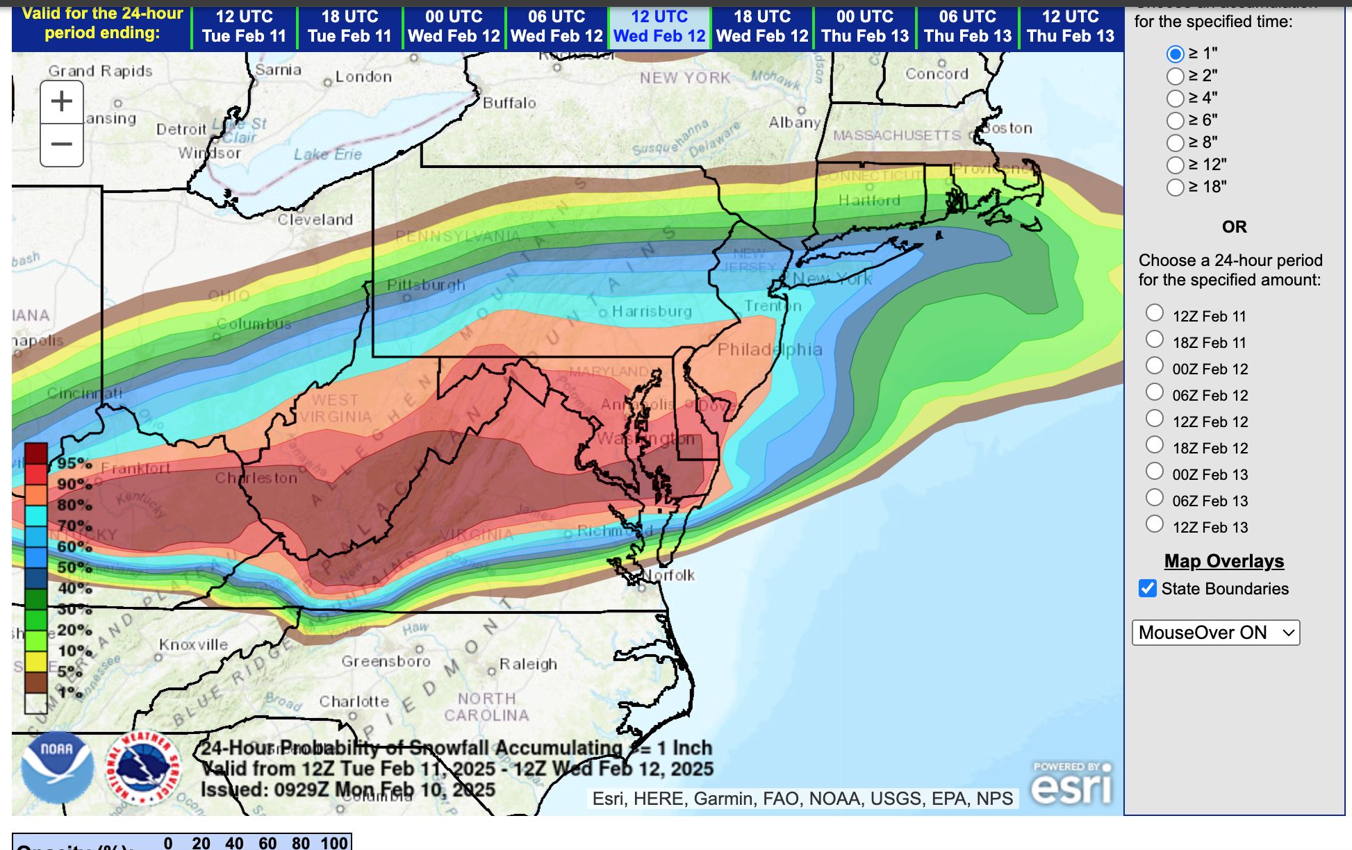
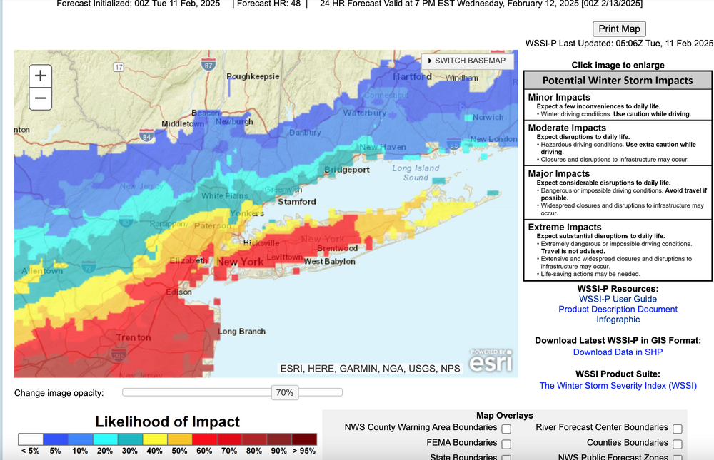
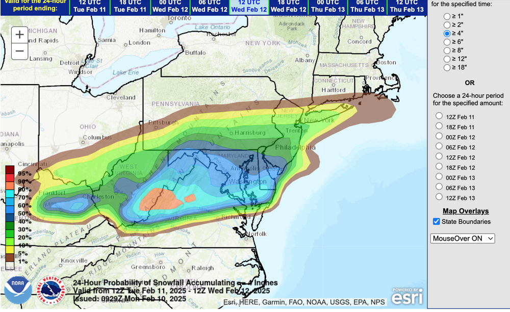
Most of the snow tonight. Areas of light snow, flurries or possibly freezing drizzle may linger after sunrise Wednesday. NWS 08z/11 ensemble probs for 1 and 4" attached. At 734AM I added what I call the slippery factor--WSSI-P, run off 05z data... the red is 60% or greater chance of MINOR impacts overnight. I sort of like this product. Edited previously intended headline start time at 327P/11 At 410AM have extended the headline into the second event since this reduces thread bounce, AND, I think that "parts" of our NYC subforum including LI, NJ, PA will see an additional few tenths of an inch of snow today with ice pellet very minor amounts this evening, and of course the obligatory icing well inland overnight. Don't be surprised at a little drizzle-freezing drizzle for LI and the NJ coast today. The additional snow may not stick very well during the daylight hours as temps rise. Still suggest cleaning the snowboard AT MOST once every 6 hours and see what you get. I hope we get some decent rainfall overnight. Thank you for all your shares. I am considering starting the 19th-20th snow storm-event late this morning.
-
Hi!. Will start the OBS thread tomorrow morning so no one gets confused with too many threads. Been debating whether to run it for two events but for now will probably be 4P Tue-Noon Wed, figuring no problems anywhere Wed afternoon except nw NJ hills into the Poconos. Have seen this before where a snow event occurs (tomorrow night), then the northeast wind saturated lowest 5-10k keeps spitting pockets of pesky light snow, freezing drizzle-drizzle (temp dependent) through the day Wednesday. Below what WSSI-P is saying...minor travel problems for s LI. So it occurs at night when fewer are on the road and below criteria for an advisory, but this to me looks like slippery stretches at times up to I80, NYC-LI as the northern edge travel issues. I'll check back tomorrow morning 630-8A.

-
These are self explanatory from this mornings 4AM cycle. I'll add the OBS thread for tomorrow at 8PM tonight.


-
It is snow and ice. I've attached NWS storm reports also showing multiple 1.2" near New Brunswick. Is it possible you missed a 45 minute period of heavy wet snow? Best I can do for you... I'll accept CoCoRaHs any day, except if a decimal point mess up or combining two days in one. CoCoRaHs is accepted for Climate reports. This may not help, but best I can do in a hurry.

-
No changes tonight to the headline. Not worth it. Keep on going.