wdrag
-
Posts
5,045 -
Joined
-
Last visited
Content Type
Profiles
Blogs
Forums
American Weather
Media Demo
Store
Gallery
Everything posted by wdrag
-
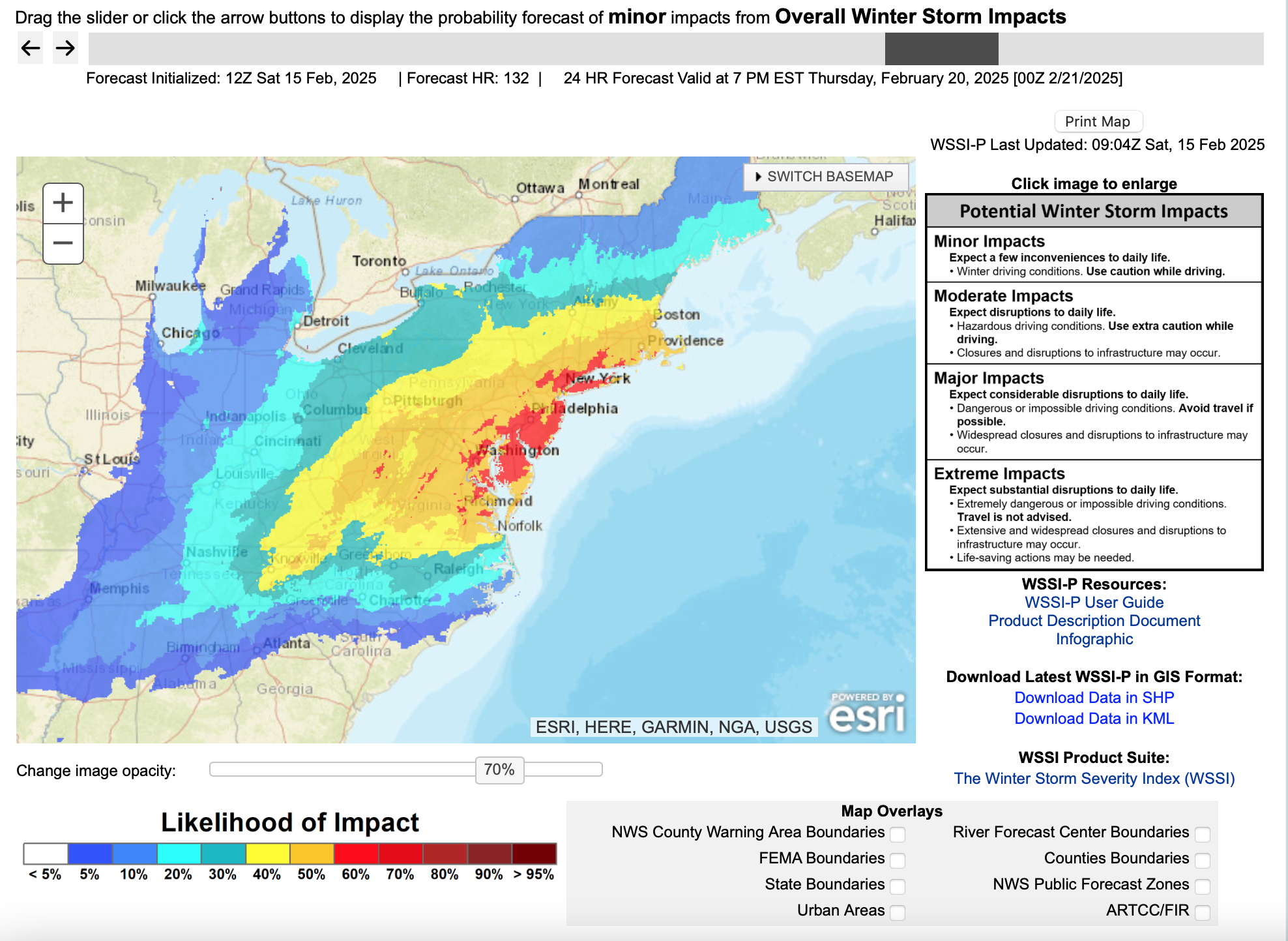
This thread should essentially close out the multi event thread, transferring event comments and serving to report snow/ice obs later today-tonight, rainfall totals sometime Sunday, followed by wind gust reports 50MPH or greater including damaging wind late Sunday afternoon-midday Monday. One graphic added is the ECMWF EPS max wind gust graphic 1PM Sunday-!PM Monday... highest gusts showing up on the ridges and mainly late Sunday afternoon-midday Monday. Sometimes this graphic can be too strong with wind gusts 5 to 10 MPH less than modeled... still even if its a little less, the strong wind is probably gong to impact some of us late Sunday-Monday morning. The hope for our I84 friends is that the east facing slopes of the hills above 1000 feet will see temps rise above freezing tomorrow morning to melt snow and ice off the branches (watch for falling frozen debris) or widespread power outages would develop, especially Catskills-Litchfield Hills and possibly the northern Poconos. As it stands, some power outages expected here and there and probably a good idea to shelter everything that is vulnerable and preventable from some damage. AI ECMWF 2m 6 hr temps have risen a bit cyclically through the 00z/15 cycle but still looks problematic whether it rises above freezing north of I94 Sunday. No matter, that region along and N of I84 should try to safely remove snow and ice early Sunday afternoon from travel ways, or it will probably freeze solid Sunday evening and remain through the work week.

-
Discussion-OBS snow event sometime between 06z Thu 2/20-12z Fri 2/21?
wdrag replied to wdrag's topic in New York City Metro
Good morning... no headline change to tighten up the window of opportunity for the midweek snow... and it's seriousness. WPC did not upgrade the 1/4" frozen qpf probs in the megalopolis swath in its mid shift production, still having us on the 1/4-1/2" edge of qpf. fwiw...what I've told my FB group...Next Wed-Thu Feb 19-20 northeast USA: Think about options if delays in powdery snow sometime in this period, We're not sure if this will be the big snow storm of the winter for the DC-BOS megalopolis as advertised by the Canadian and European models or a grazer as proposed by the United States modeling but there will be a period of snow. We just dont know how serious. Dont make flight - outdoor plan changes yet, but think about your options, especially I95 corridor to the coast. ---- The attached is experimental, objective and tends to be conservative, especially longer ranges. Also attached the 00z/15 GEFS-CMCE around a 50 member blend which offers a 3-6" snow event here on LI-NYC... sort of a general idea. This adjusts with time as the model ensembles adjust. Not a done deal on snowfall... imo a good way to play this... snow coming but how much? I noticed the GEFS doesn't want to close off the upper low in NYS and even the EPS is faster and slightly less amped. I definitely am not thinking blizzard or anything like that right now... one has to consider faster-weaker-further east trend but maybe it will still produce a nice 4+ snowfall DC-BOS?
-
I'll set the OBS thread for this final piece of the thread at 8AM tomorrow. When it begins which will probably be NOON Saturday-6PM Monday. I'll define it as snow/ice reports (most on LI/NYC will be through 10PM Sat), then I'll add damaging wind gusts and recommend gust reports 50+MPH for Sun night-Monday, and if you wish... you can add but certainly not necessary, your FEB rain totals through the 16th. The attached map sets the baseline of about where we are the first 2 weeks. WPC has us generally 1.5" qpf here by Sunday evening. Maybe we'll have CP Feb snow total by tomorrow nights 1AM CLINYC, up to near 8"? There's a chance ... depending snow qpf and melting on contact.
-
Discussion-OBS snow event sometime between 06z Thu 2/20-12z Fri 2/21?
wdrag replied to wdrag's topic in New York City Metro
All ensembles at 5H similar t 144 hrs. That's good! I definitely like " snow likely" Thu. WPC has pretty high probs for D6 frozen here... all ensembles have snow. So there's a 30% it wont snow... do we say chance? I say not... in fact its why I'm still on the forum and doing my FB stuff. It's because we don't say enough soon enough... we see it in modeling and may say it in the AFD but the forecasts don't necessarily broadcast it cause we have a conservative approach, afraid to be wrong etc. We can do much much better telling folks 5-6 days in advance what is coming... in broad sense and these threads demo. Not always right but certainly better than a 50/50 coin toss when you use cyclic ensembles to build confidence. Modeling science is ahead of us using guidance to our preparation advantage. -
Discussion-OBS snow event sometime between 06z Thu 2/20-12z Fri 2/21?
wdrag replied to wdrag's topic in New York City Metro
I'm not thinking rain at all... looks too cold... my main concern is that 5H closes off to our nw in NYS.. otherwise if it closes too late over BOS, most of this is to our south and southeast---just my thinking. 18z GEFS has snow (despite the nil op) but max axis Southeast of us... that's my concern... if it doesn't amp, it slides out to our se. -
Discussion-OBS snow event sometime between 06z Thu 2/20-12z Fri 2/21?
wdrag replied to wdrag's topic in New York City Metro
Headline may adjust Monday based on consensus for whatever-whenever. Right now the goal posts are very wide for possibly a 2 part event... instead of one major Nor'easter (or distant OCEAN storm?). Its's good enough for this weekend unless WPC ensembles upshift to say 70% or greater for .25 frozen w.e NYC-LI. -
Discussion-OBS snow event sometime between 06z Thu 2/20-12z Fri 2/21?
wdrag replied to wdrag's topic in New York City Metro
I just respond to critics. This is the bigs so to speak... (DC-BOS) it all works both ways. What we get on here are some insights and maintaining situational awareness-reality checks. Adding the 12z GEFS which is snowier than the op... telling me a primary snowfall Va-Delmarva, but also their must be a cluster of members trying to send something up the coast, with quite a wide area of 1". 12z/14 GEFS, despite its 12z/14 op, says to keep monitoring until the EPS/CMCE say no snow up here. I think this fits the just released D6 probs as posted. a bit above in this thread.
-
Discussion-OBS snow event sometime between 06z Thu 2/20-12z Fri 2/21?
wdrag replied to wdrag's topic in New York City Metro
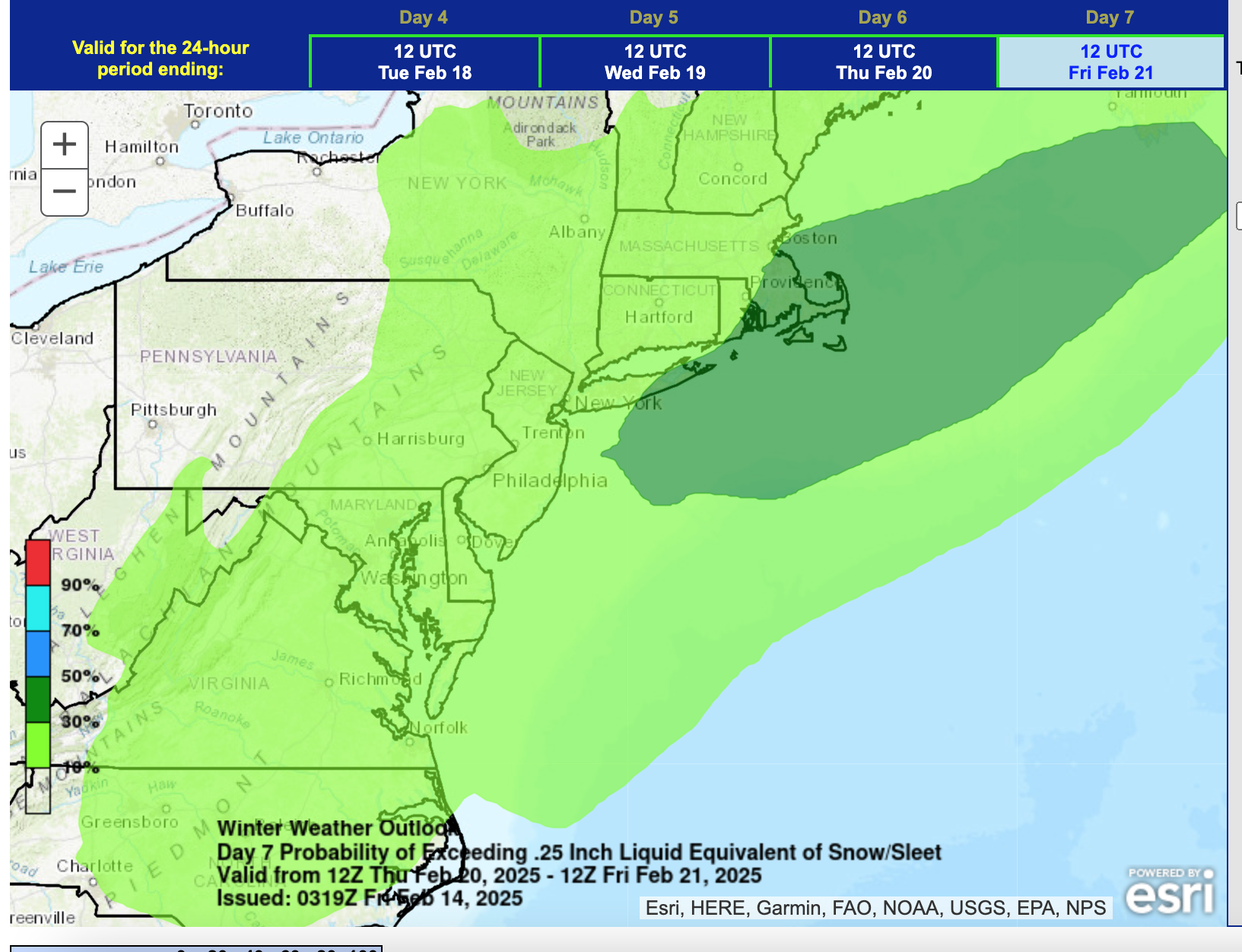
WPC D6 probs... hope it holds up here as we progress daily. Based primarily on 00z/14 guidance... NAEFS was good with this also, as also the BOM which has 6+ over all of NJ-LI by 12z/21.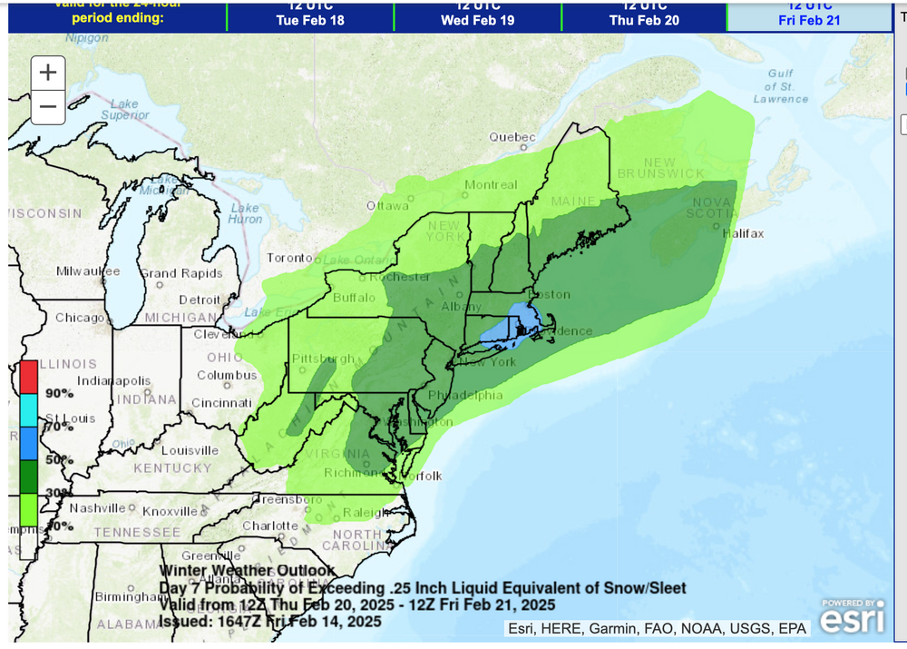
-
Am watching AI and colder Canadians for this Sunday... downslope - no qpf would lead to the interior warming Hud Valley and w of the Catskills. AI just doesn't buy it... sooner or later AI will have give it up toward other model solutions, or we have a pretty big problem interior east facing hills along I84 from ne PA-nw CT, W MA. So this will be a learning curve for me on AI 2m temps being within 4F of predicted at the selected hours.
-
Discussion-OBS snow event sometime between 06z Thu 2/20-12z Fri 2/21?
wdrag replied to wdrag's topic in New York City Metro
WPB 16 %6-7 qpf attached Their 1/4" frozen probs were not available yet as 1144AM/14. I just want to caution... the headline said nothing about a big snow storm. It just said snow event and the initial thread body cautioned. Far too early to know and I'm a little worried the EC weeklies were too dry and negative about an event here from yesterdays 00z/13 cycle. If the modeled 5H closed low ends up positive tilted, this system could easily be mostly a miss. Can't put all our eggs in one basket except imo, to respect that there are different interests herein and not all will be satisfied with the thread, wishing for their own outcome. My goal on these threads is to alert us for more snow acc into CP and a potential hazardous wintry event for NYC-LI, not outlook a snowstorm 6 days in advance---just hard to do. We do know we have something significant on the horizon but the axes of max snowfall can easily be far different than what we see D6-7. Hope yes, but reality in advance is not confidently known, as yet. IF the EC suddenly loses the current predicted 500MB pattern, then its a se fade more for NC-Delmarva. -
Worst probably ridges. Nothing you can do... except shelter what you can and I would not be driving around casually later Sunday night-Monday in the ridge areas. High profile vehicles probably impacted. Offline for a while.
-
Thread started for 2/19-21. You're welcome to transfer energy there. Doesn't need to be pinned for a couple days even though its currently an item.. the event is likely to adjust and it could be less meaningful here, especially since it's a northern stream short wave based. I'm kind of playing it down right now... not to get more hyped up than what the ensembles were showing in the 00z/14 cycle. If the ensembles fade there will be considerable disappointment.
-
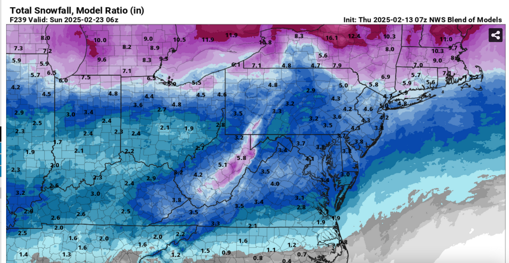
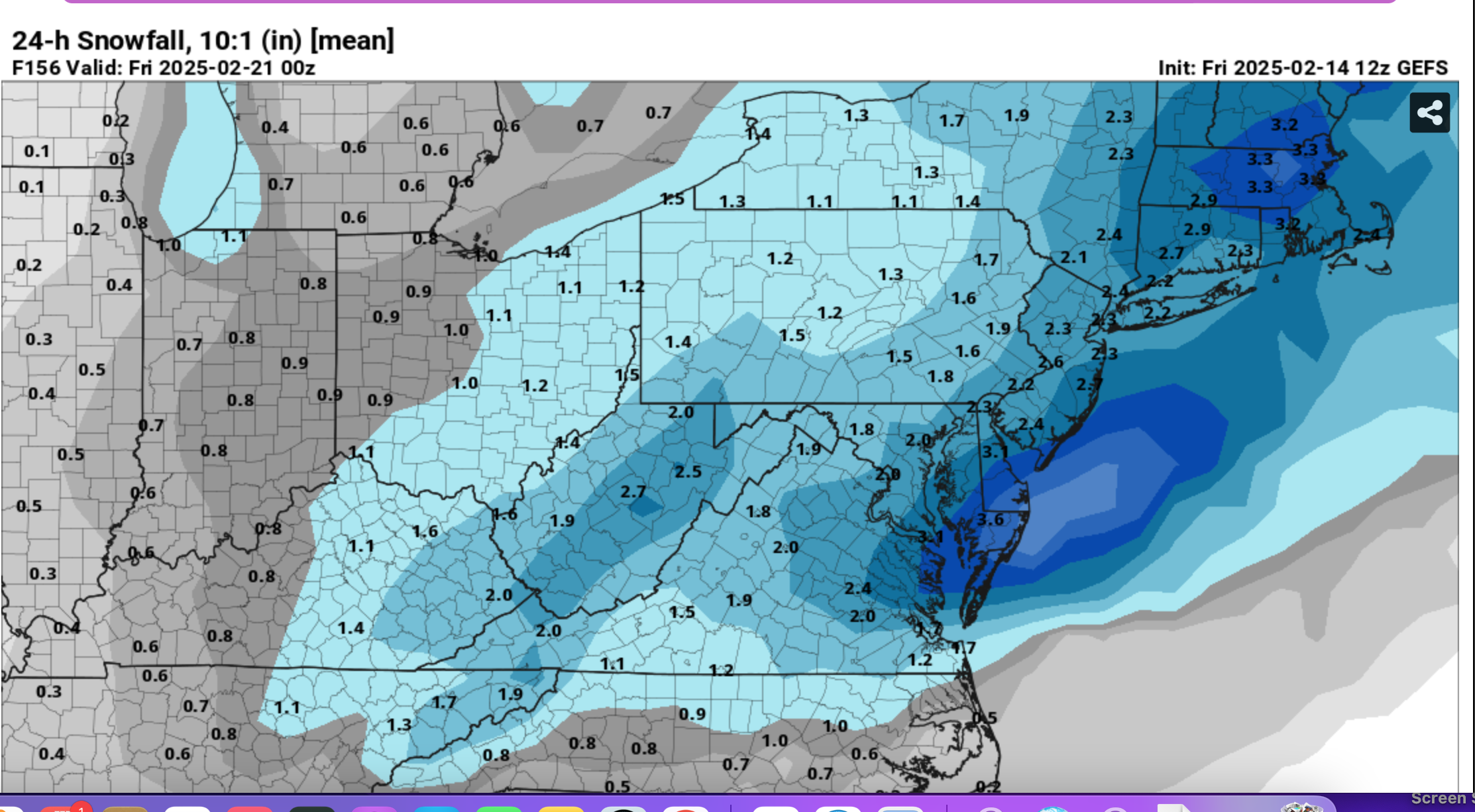
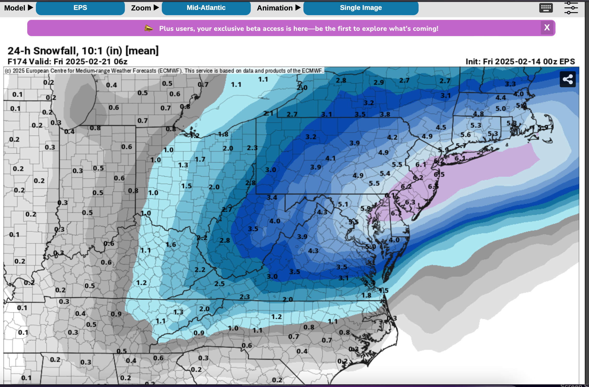
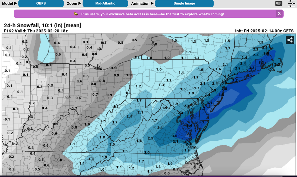
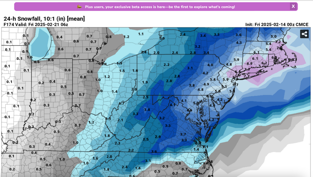
Thread started due to 3 successive cycles of the EPS/GEFS/CMCE showing 1+" in 24 hours and amounts increasing through the most recent 00z/14 cycle. Will this be relatively benign snowfall only raising our monthly total close to normal, or could it be our first 6+ Central Park event since late Jan 2022? Whatever happens, it looks like powder (presuming it snows an inch or more in CP), with some gusty north-northeast winds. Graphics: 00z/14 cycle WPC D7 and GEFS,CMCDE, EPS 24 hour (10 to 1 ratio) amounts with various ending times late Thu the 20th or early Friday the 21st. Reminder: These ensemble snowfall axis can be in error by over 100 miles on a D6-7 forecast so the modeling provided is not a lock where currently placed. 7PM 2/17/25: adjusted headline to narrow the timing goal post of what has become a much more uncertain event since initially proposed...even with the option of no snow. This despite a strong short wave passage Thursday evening. The GEFS still closes a low through PA while the EPS has weakened to an open - less ominous progressive short wave trough with no significant 850 MB onshore circulation. The 15z/17 SREF, 18z/17 NAM and 12z/17 JMA are the only models with any significant hope for snow as the globals have largely faded southeast since thread inception. The apparently lagged average BOM and 12z/17 WPC still maintain an opportunity for a period of light snow (1/2-4" nw to se on the BOM).


-
Based on the 00z/14 OPS and so far the 00z/14 GEFS, barring a 00z/14 CMCE/EPS miss, I'll have the thread going at 720AM with some base ensemble info. We hopefully will have something more than minor-moderate events that already are contributing to a nice winter here in the northeast. This one looks like powder, drifting snow?
-
I think this is a warnable WS for the Poconos and on up north of I84 due to combined freezing rain accretion preceded. by 2 to possibly 6" of snow Sat aft-eve per ensembles and ops. The hope is that a lot of the freezing rain depicted is sleet... difficult to remove, but prevents 1/4" glaze which I think is more damaging for birches and white pines. Even if the ensembles are too generous with 1.5 qpf, I think 8 tenths will. occur and most of it will be frozen or freezing there... and hopefully mostly snow-sleet. Additionally, and we dont know yet where this will ut wherever the glaze is heavy, winds should be gusting 35-50 MPH beginning near midnight Sunday night and if glaze still remains that's a branch breaker-power outage maker For now low prob until we know ice and temps Sunday. So, there are unknowns of course but for sure, at a minimum it will be hazardous Sat aft-night in the Poconos, and nw NJ Sussex County with subfreezing temps and accumulations. One other supporting piece... I'm starting to track AI EC 2m temp... it did a good job in the cycles leading up to today (12z this morning and now 00z/14) and its comparatively colder than most other models for Sunday morning-midday. Also, you'll note the low pressure system trying to move into Central NYS has a lobe of pressure falls along the warm front s of Li. That focuses some of the heavy qpf there, but also traps cold air in the interior due to a tendency for winds to cross the isobars toward the max Pres falls near LI-Cape Cod.
-
2/19-20... nothing right now from me... as other have stated..a thread for this possibility can wait... certainly GFS has misgivings as do some of our group. Will check again tomorrow. Walt
-
My guess is WS watches will post tomorrow morning for much of the I84 corridor roughly Noon Sat-Noon Sunday and they'll hold advisories till sometime tomorrow adjacent to the watches. We'll see how they'll handle based on internal greater data resources/expertise and collaboration, which is a time consuming process.
-
I probably will start a thread this evening or tomorrow morning for 18z Wed 2/19 -Fri morning 12z/21 20, pending 18z GEFS. 12z GEFS was lack lackluster and yet still could be right though I dont think so. Then the question becomes is much more than 4" and your start end times etc etc. Looks like powder to me embedded within a cold subfreezing week. WPC already has us in 10-29% chance 4". Also the thread for Saturdays roughly 1-maybe 3" LI/CP, heavier nw suburbs where ice will be problem too... that should begin at 7A Saturday, and will include damaging wind gust for 00z/17-00z/18 Sun night-Monday. Back later, Thanks for posts on modeling etc.
-
That's what CoCoRaHs said...the surrounding datapoints look similar. I was in the Poconos this morning... their glaze at 2000' was twice mine from overnight (Wantage 0.05-0.08 radial), but essentially not damaging from what I could see nor anything posted in the NWS LSR's. Going to be more serious Saturday night-Sunday morning,
-
Thanks all for your feedback... When I look at NY metro, I try not to get lost in the weeds... if CP is cold enough to snow, usually I think LI is, especially N shore with the various considerations of SST, depth of cold air hanging on at any point. I'm moving on, trying to be reliably close to what will occur. You're welcome to straighten me out-any time.
-
Thanks for the briefing. Yay!
-
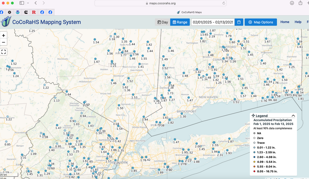
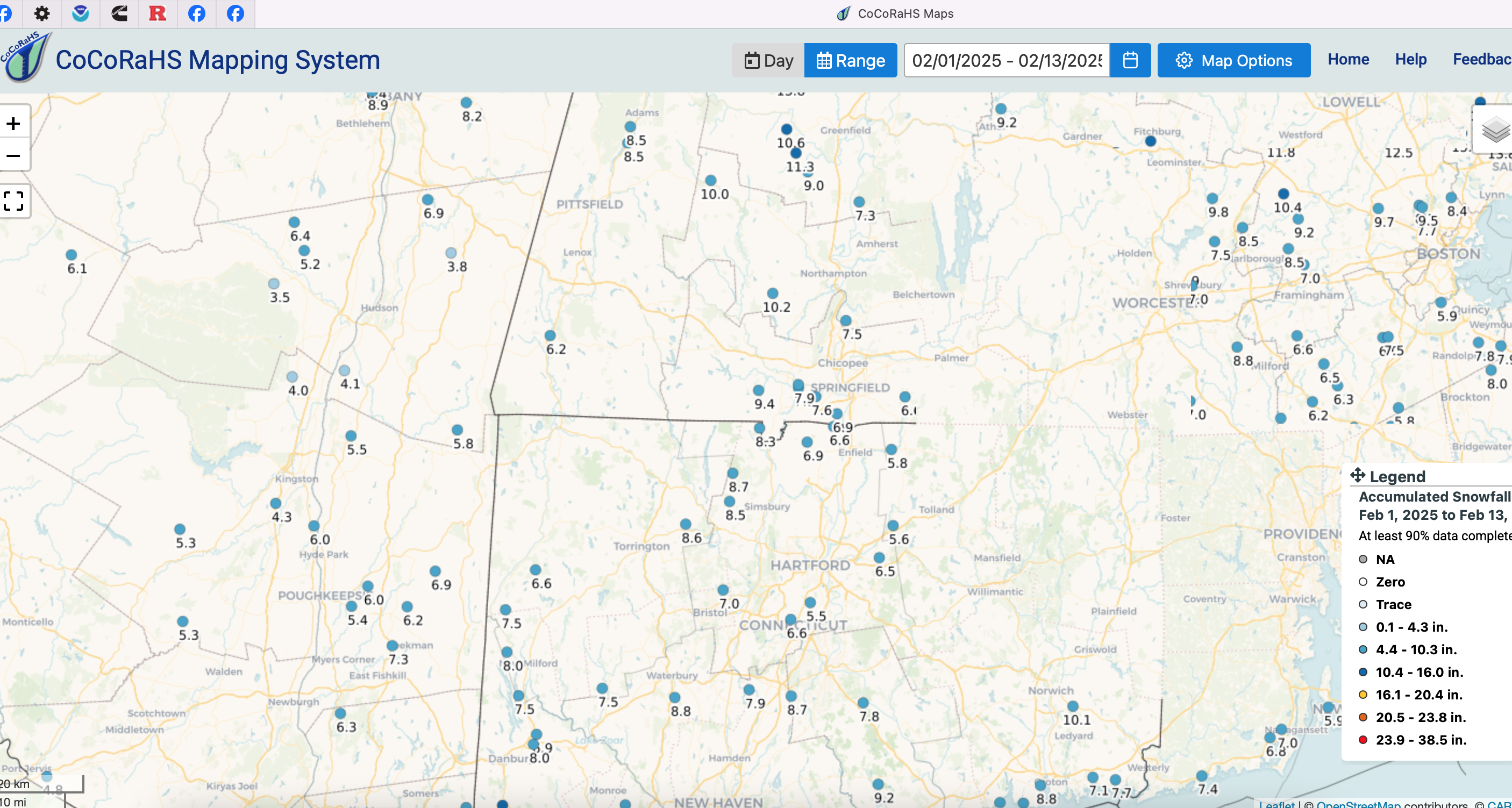
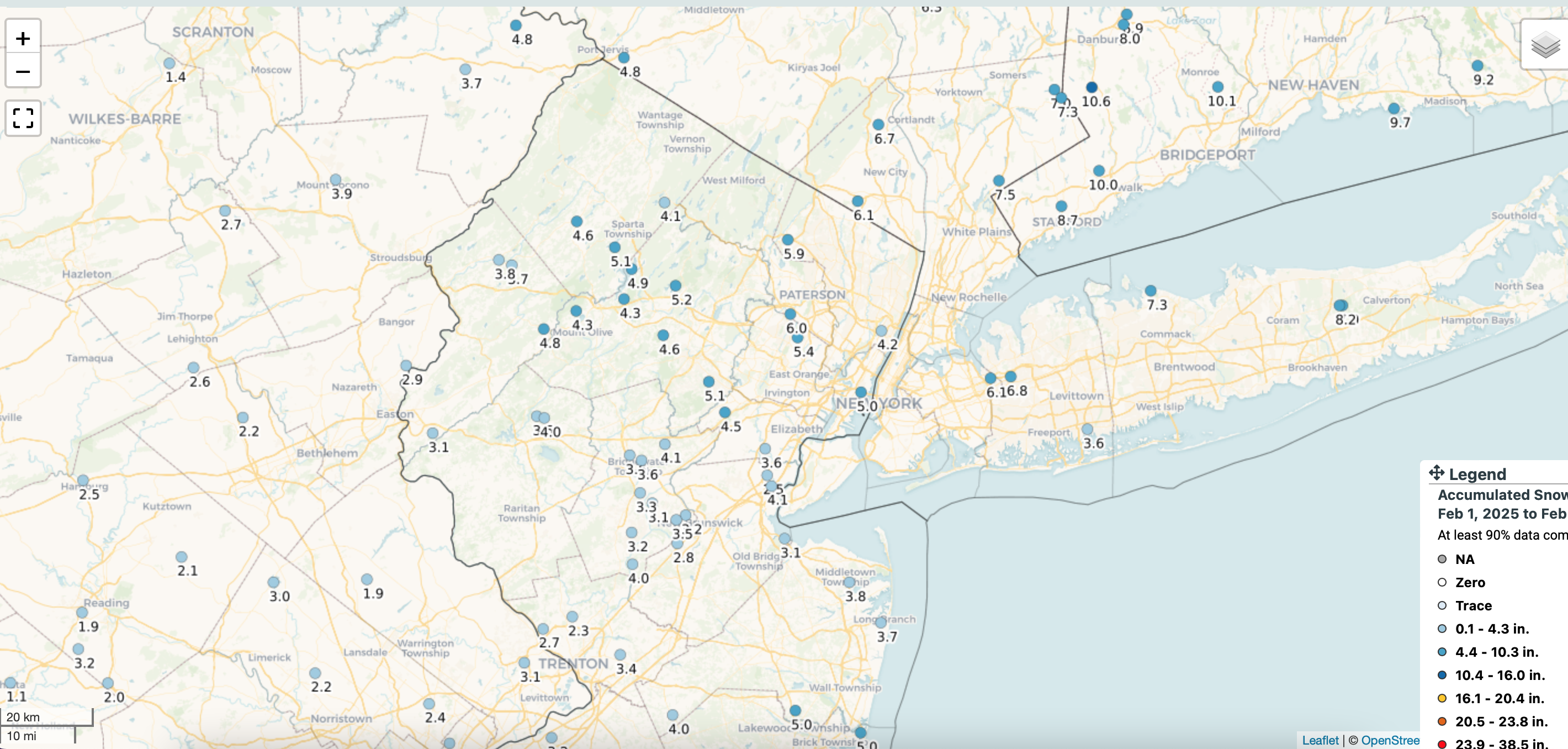
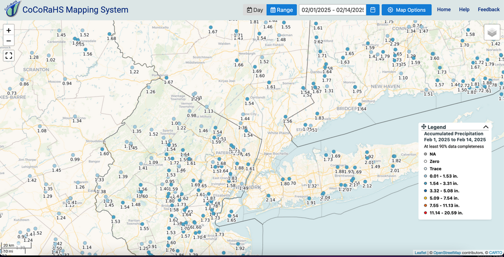
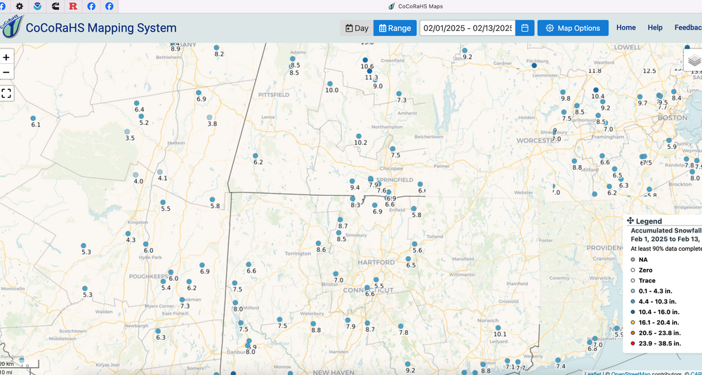
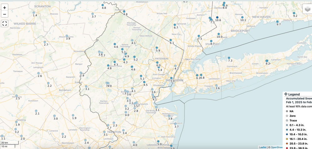
As usual click for clarity... so for Feb about 30" so far in the Adirondacks and attached for I84 and NYC metro. Not bad... our Long Islanders northward hopefully continue relatively happy with Feb snow. Am pretty sure our ne PA/NNJ folks will catch up. Have a day...back at 530P.
-
OBS-Nowcast for snow 4P Tue 2/11-7A THURSDAY 2/13/25 Mainly NJ-NYC-LI.
wdrag replied to wdrag's topic in New York City Metro
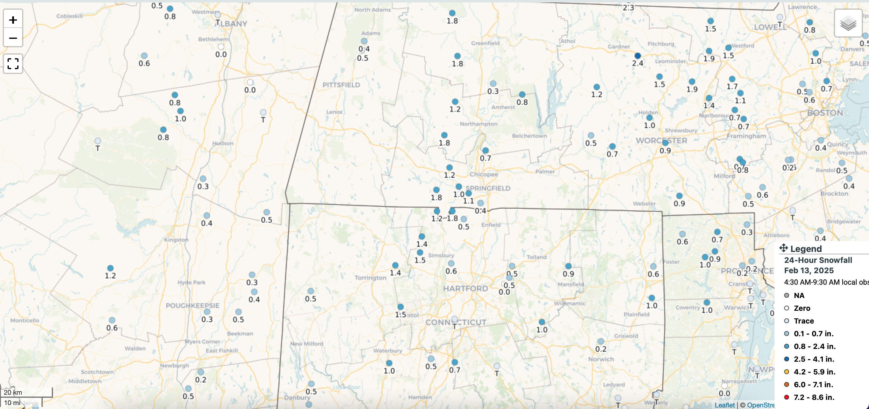
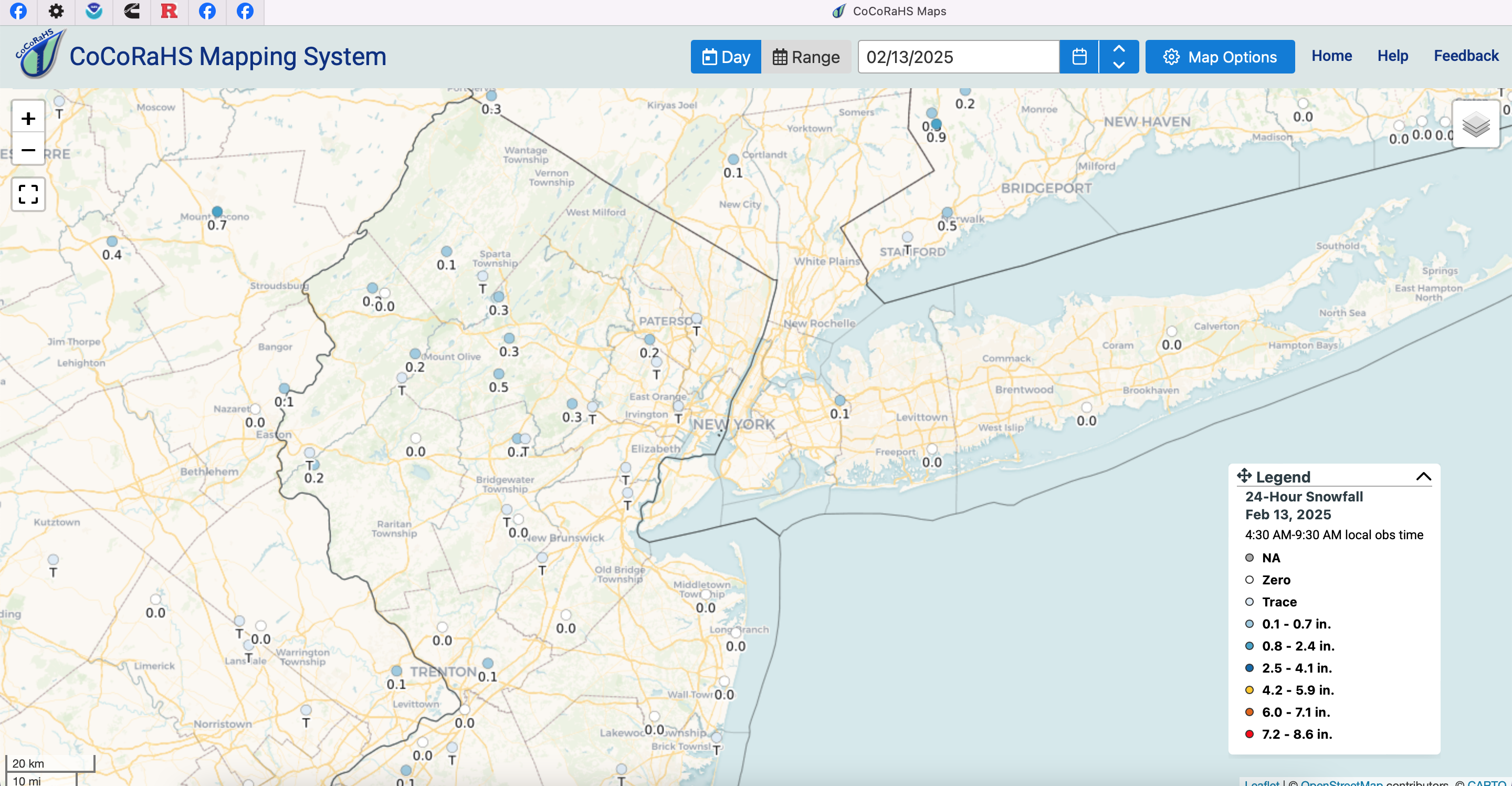
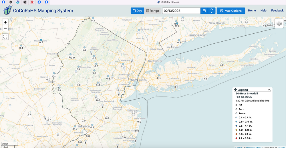
Past 24 hours snow and sleet totals... ending around 8A/13. Includes 0.1 CP and 0.2 Wantage. As usual click for clarity.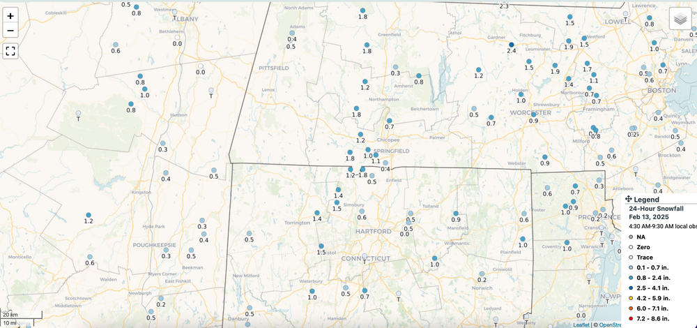
-
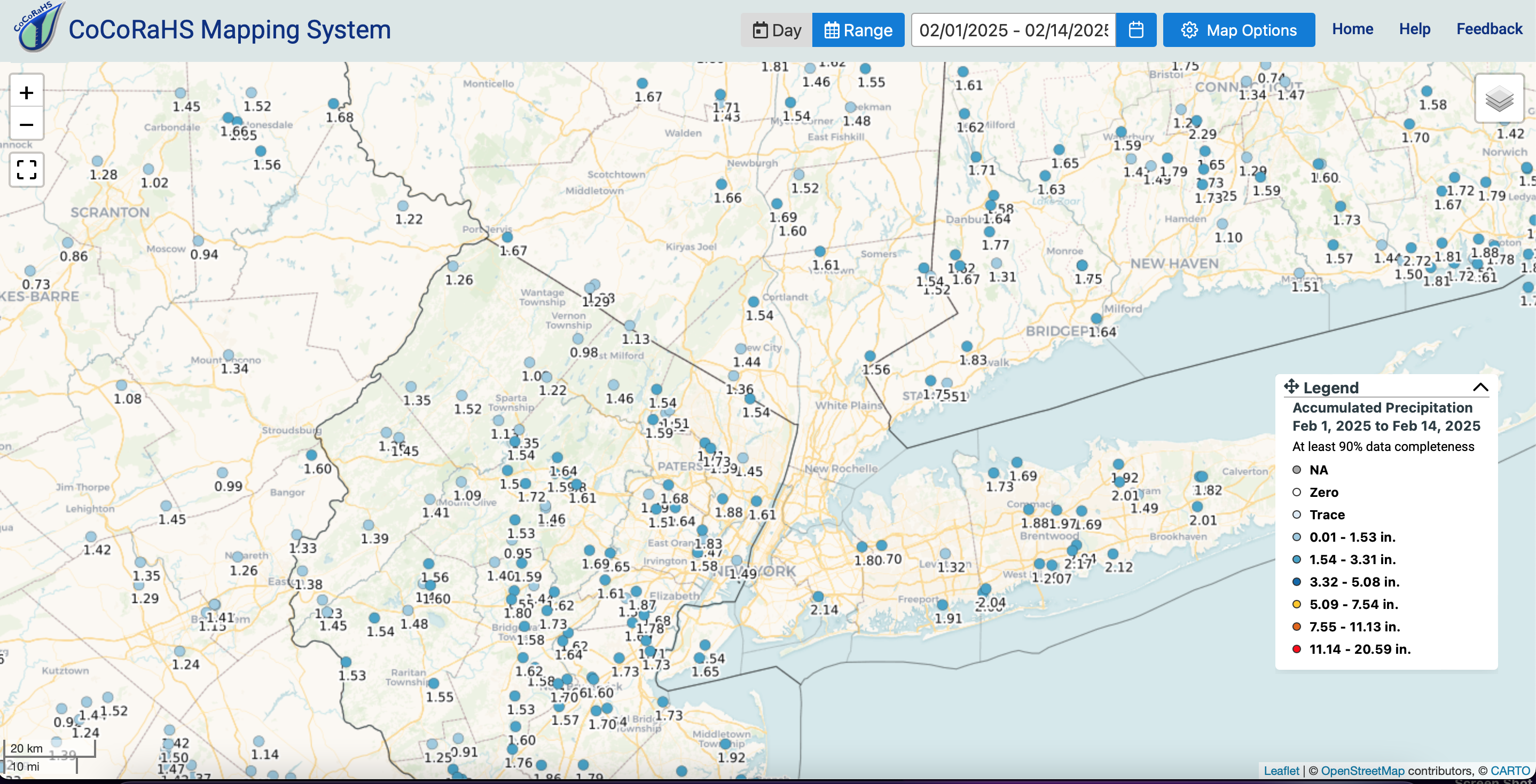
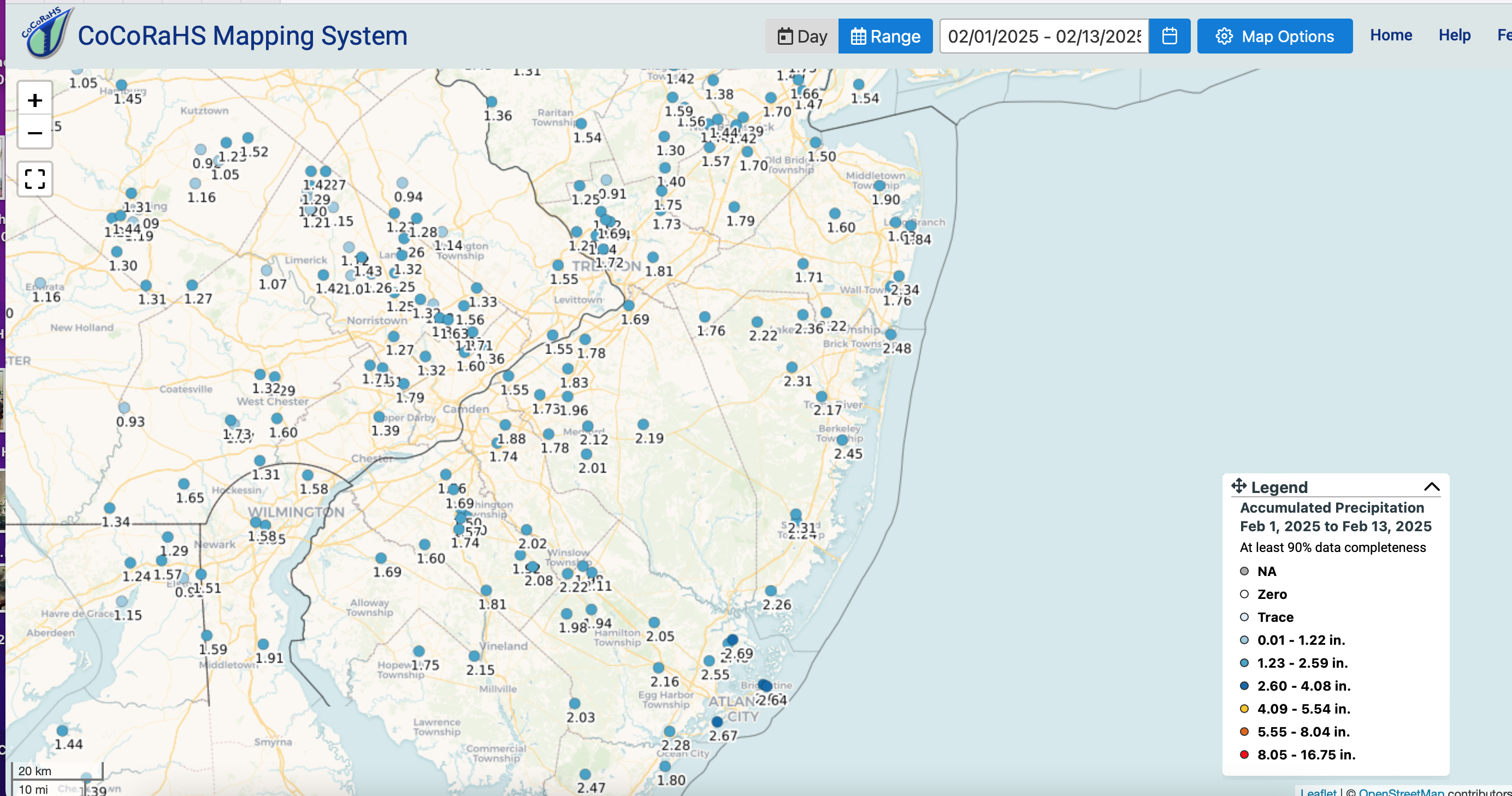
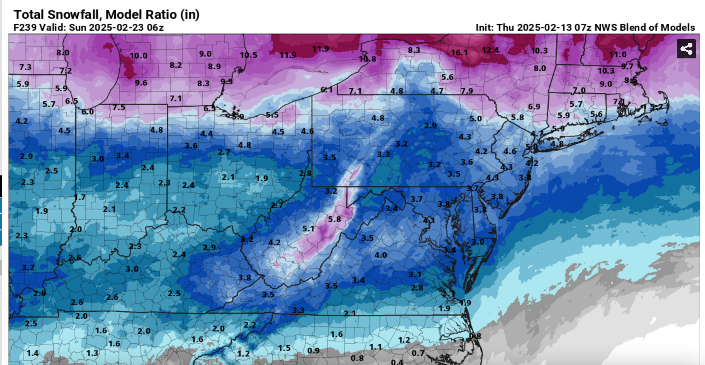
fwiw: The basics so far in rainfall essentially the first 12 days of the month...heading for monthly 3.5-4"...pretty good for the GEFS way back around 1/31 (seen in Pivotal) Also added the 240 hr BOM snowfall.