wdrag
-
Posts
5,045 -
Joined
-
Last visited
Content Type
Profiles
Blogs
Forums
American Weather
Media Demo
Store
Gallery
Everything posted by wdrag
-
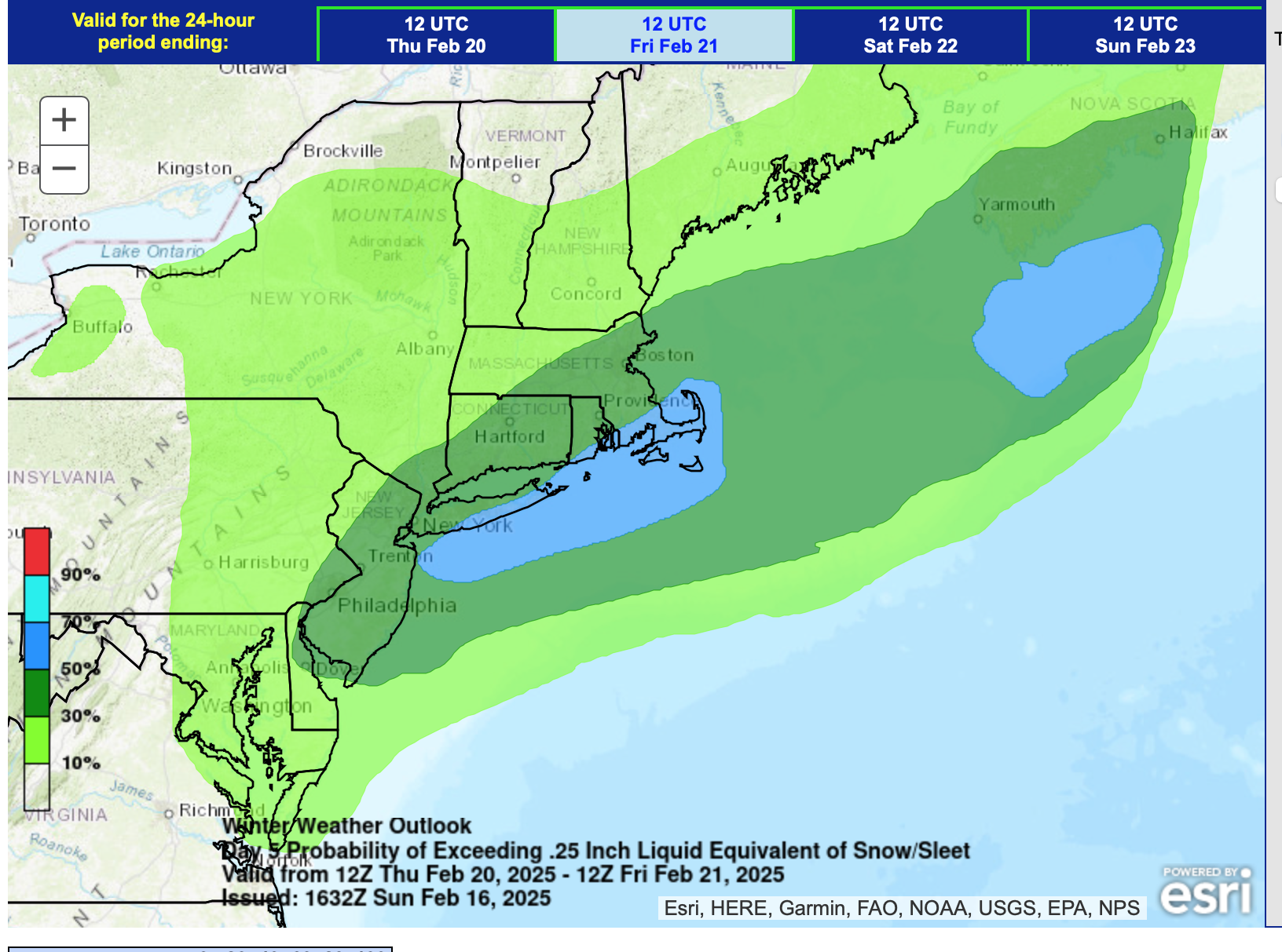
Discussion-OBS snow event sometime between 06z Thu 2/20-12z Fri 2/21?
wdrag replied to wdrag's topic in New York City Metro
Of course I worry but we're 96-108 hours out... we are modeled to be grazed and that's kind what the thread P!- headline tried to caution. I dont expect a big one here, but I continue 2-6" for the NYC subforum. Maybe I'm too high, but I think being steady with the original perception and cautions is working. Maybe WPC is too strong too? per it's attached 16z/16 issuance for D5 Thursday, using the legend color bar probs for 3" or more of snow. I'll throw in the towel tomorrow afternoon if all the 12z-18z/17 ensembles are less than 1" NYC. High pressure WAYYYY out west and room to edge north. Enjoy what you can in life...
-
Discussion-OBS snow event sometime between 06z Thu 2/20-12z Fri 2/21?
wdrag replied to wdrag's topic in New York City Metro
NO consensus... it has to start here by 12z Thu. -
OBS-Nowcast Noon Saturday 2/15-Noon Monday 2/17
wdrag replied to wdrag's topic in New York City Metro
50 Sandy Hook... I agree Manhattan and LGA not 50 there but its not quite done. Dense fog tells me heat is just a few hundred feet above you. -
OBS-Nowcast Noon Saturday 2/15-Noon Monday 2/17
wdrag replied to wdrag's topic in New York City Metro
High dew point above shallow cold.. will try to mix. Not doing it in PHL and doubt if it does NYC, though as Bluewave said... JFK eastward along the s shore looks briefly very mild at 4P. There's your fog where unmixed and high inverted above shallow cold. Not liking how its still 31.6 here in Wantage at 118PM with ice clinging to trees and wind ready to come up at 5P and whip into power outages. Hopefully I'm overplaying this from here north into the Catskills nw CT and W MA but its already busy in PA/NJ/NYS/CT with power problems. -
OBS-Nowcast Noon Saturday 2/15-Noon Monday 2/17
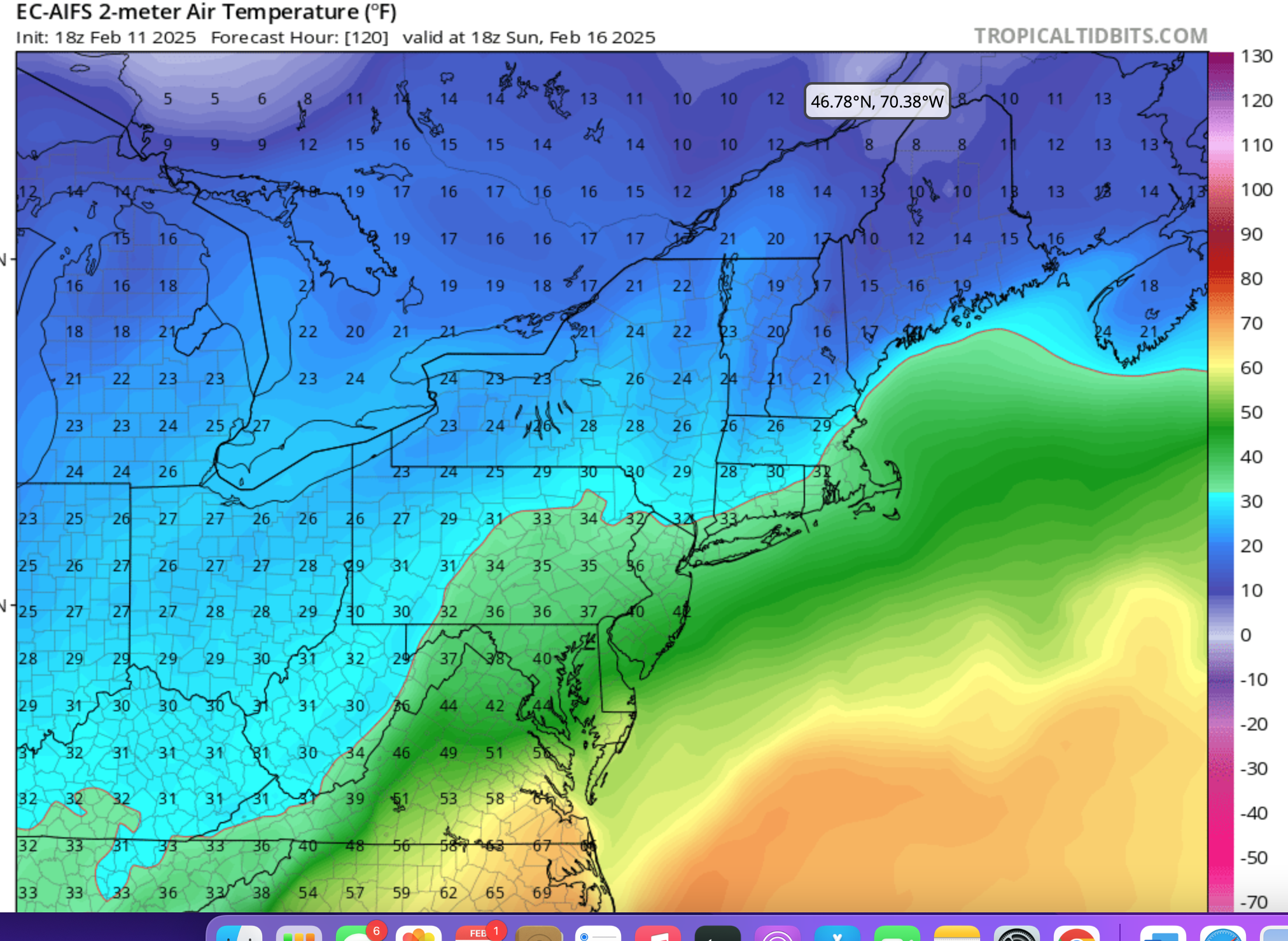
wdrag replied to wdrag's topic in New York City Metro
Cherry picking but if you go to Trop Tidbits, globals ECAI, 2m T at 18z today, then go back all the versions you can, at least back 120 hours, you'll see how consistent the ECAI was regarding todays 18z T. Its running a couple degrees warmer, especially central NJ but at 120 hours, and then you keep seeing how the cold was tucked in, you should be impressed with this modeling and how threatening this looked for ice into midday today. Click for clarity.
-
OBS-Nowcast Noon Saturday 2/15-Noon Monday 2/17
wdrag replied to wdrag's topic in New York City Metro
https://www.ncdc.noaa.gov/stormevents/ You can search by state, date etc. STORM DATA. -
OBS-Nowcast Noon Saturday 2/15-Noon Monday 2/17
wdrag replied to wdrag's topic in New York City Metro
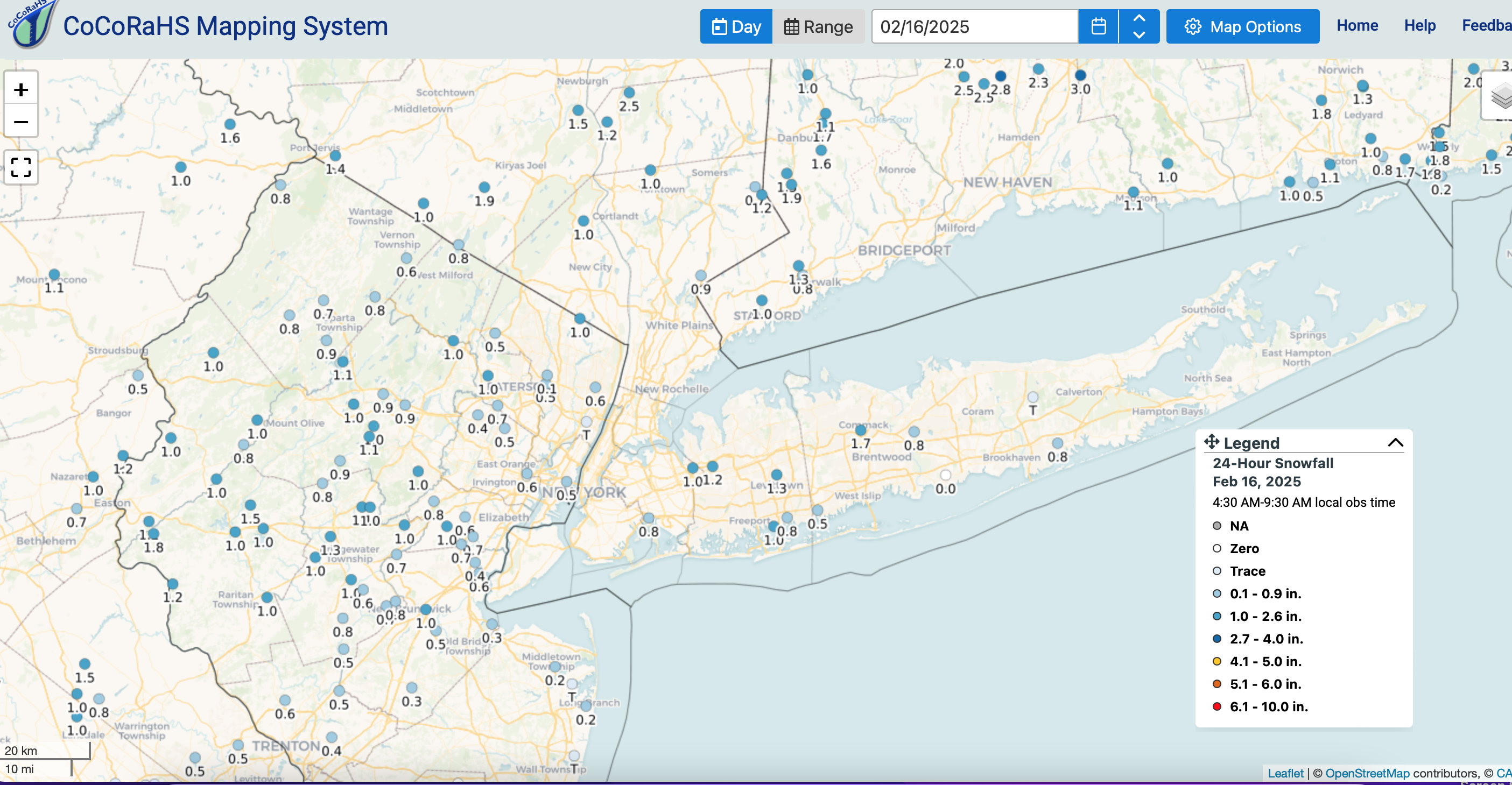
CoCoRaHs snowfall yesterday, parts of the widespread 1/2-1" qpf the past 24 hours ending about 8AM. I know its less than I anticipated I80-II84 corridor NYC WEST to nw NJ and the Pocs. The icing is making up for it... Click for clarity if interested.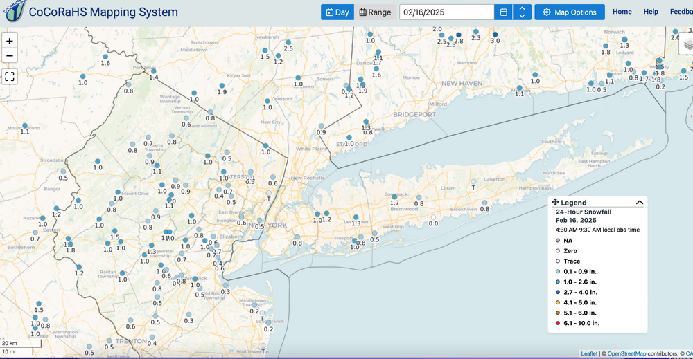
-
OBS-Nowcast Noon Saturday 2/15-Noon Monday 2/17
wdrag replied to wdrag's topic in New York City Metro
Wantage NJ 935A 31.1 and drizzling drizzle. Radial thickness 0.20 and branches, small trees coming down. Power outages so far scattered but you can see are increasing in CT/PA and soon e NYS. Will try to get pics out soon. -
OBS-Nowcast Noon Saturday 2/15-Noon Monday 2/17
wdrag replied to wdrag's topic in New York City Metro
I saw Bluewave EC High res post but if it hits those numbers its for 3 hours only in mid afternoon. For one thing... a south wind is now drawing on modified cold off the ocean and interior NJ down to BWI. yes it can hit those values but if the wind goes light south and shifts strong west, it wont grab the coastal NJ warmth. There is time... imo, unless someone disagrees (lets have it!), the EC AI had nailed this days in advance a reason for my alarming post a couple days ago about icing and branches. EC AI is only 6 hourly for me but it's good. On sunny days I view out as a BL T (add 10 for a max). On precip days, its the number within 2F. -
OBS-Nowcast Noon Saturday 2/15-Noon Monday 2/17
wdrag replied to wdrag's topic in New York City Metro
Pressure fall modulations as wind blows into pressure falls if he ardent is not strong. Allows pockets of colder air nearly to to your north-northeast to return for a little while. Still 30.2F here in Wantage. NAM3K and ECAI 2meters temps seems to have the east fit. -
OBS-Nowcast Noon Saturday 2/15-Noon Monday 2/17
wdrag replied to wdrag's topic in New York City Metro
Wantage NJ: 610AM report... estimating radial glaze now about 0.15". its accumulated further top side and now bottom as well on rose bush branches. HARD ice on deck. temp briefly up to 30.2 around 4A but has since dropped to 29.7. fwiw: 350 meters without power near High Point NJ. -
OBS-Nowcast Noon Saturday 2/15-Noon Monday 2/17
wdrag replied to wdrag's topic in New York City Metro
Lots going on here the next 24 hours, mesoscale Pres falls alter wind directions-hourly temps radically near the freezing line boundary I84 corridor with icing continuing well into the morning higher terrain there. Presuming it does rise into the upper 30s there this afternoon, ice on branches will drop and melt on you-cars, and helps limit bigger damage from the 50+MPH gusts coming late this afternoon into tomorrow morning. The rapidly intensifying storm as crosses I84 or I80 (occluding) imo argues for the powerful winds and scattered power outages coming. Not impossible to have SVR's issue mid-late afternoon I80 southward in the warm sector. I'll try to support with reports but after 2PM, probably a no show most of the time with GrandPa duties. -
Discussion-OBS snow event sometime between 06z Thu 2/20-12z Fri 2/21?
wdrag replied to wdrag's topic in New York City Metro
Good Sunday morning everyone, As you're assessing... I've no change to this headline. Might adjust it Monday if I can shorten the window of opportunity. Despite several ops missing to the southeast of us, the strength of coming shortwave, and the already in place snowstorm for the Delmarva-nw 1/3rd NC (ice remainder of the interior Carolinas) tells me we'll at least be on the northern fringe of a 2-6" powder event. Room for error and the debate will continue but I'm in for snow entire NYC subforum, just how much (WPC overnight shift continues 30-50% chance for more than 3" here). This might be the last solid opportunity for Feb, with cold air in place. It wont be a KU but like yesterday's 0.2-1.8" snowfall for much of the NYC subforum, it adds up to a nice Feb, presuming my own perception from the 00z/16 ensembles is correct. Probably my last on this today and baby sitting tonight-Tue AM so time will be shorter. -
OBS-Nowcast Noon Saturday 2/15-Noon Monday 2/17
wdrag replied to wdrag's topic in New York City Metro
Wantage NJ: 3A. 0.10 glaze on top of the 0.8" snow yesterday afternoon. 29.3F. Glaze eyeballed on rose bush. Definitely thicker than a couple days ago. Walt -
OBS-Nowcast Noon Saturday 2/15-Noon Monday 2/17
wdrag replied to wdrag's topic in New York City Metro
Wantage NJ - this part: 0.8 snow-sleet, T freezing rain at 655PM. 28/27. Next report around 6A. -
OBS-Nowcast Noon Saturday 2/15-Noon Monday 2/17
wdrag replied to wdrag's topic in New York City Metro
I just Central Park webcam... snow on grass and bushes. CLI might have spoken with a person? Just have no idea what goes on there. -
OBS-Nowcast Noon Saturday 2/15-Noon Monday 2/17
wdrag replied to wdrag's topic in New York City Metro
NYC CP has had .07 melted as of 5PM... at temp about freezing. Not sure what the snowboard will say, nor what Manhattanites are seeing but there has to be measurable there...even with settling. Wantage NJ 0.8" at 5P and s-- lull. -
OBS-Nowcast Noon Saturday 2/15-Noon Monday 2/17
wdrag replied to wdrag's topic in New York City Metro
Wantage Nj, this part 1/2" at 330PM. Roads and driveways getting slushy. 27.. -
OBS-Nowcast Noon Saturday 2/15-Noon Monday 2/17
wdrag replied to wdrag's topic in New York City Metro
Wantage NJ - this part 0.3" at 240P. 27/25 -
OBS-Nowcast Noon Saturday 2/15-Noon Monday 2/17
wdrag replied to wdrag's topic in New York City Metro
Wantage NJ first 0.1" on the ground at 140P. all surfaces covered except treated roads and some driveways. -
Discussion-OBS snow event sometime between 06z Thu 2/20-12z Fri 2/21?
wdrag replied to wdrag's topic in New York City Metro
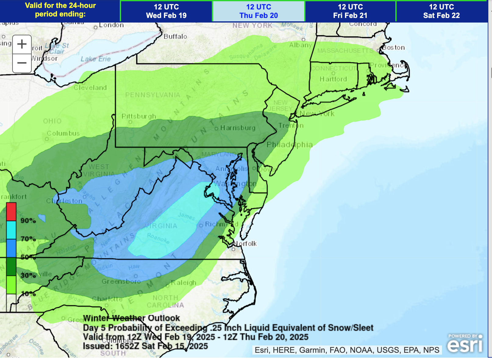
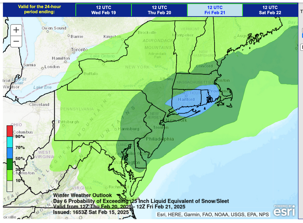
WPC axis for Wed-THU. Similar. WPC not convinced on big amounts NYC. This looks more important for Delmarva.
-
OBS-Nowcast Noon Saturday 2/15-Noon Monday 2/17
wdrag replied to wdrag's topic in New York City Metro
Snow and leet will cool 7PM temps to near 32-33F, especially cooler wet bulbs. HRRR is a little slow, EC better. sky here in Wantage filled with small flake snow 29/19. -
OBS-Nowcast Noon Saturday 2/15-Noon Monday 2/17
wdrag replied to wdrag's topic in New York City Metro
a few flurries from time to time 130PM onward in Wantage. 16z HRRR temps seem a little too warm in precip DC_BWI-PHLLY se PA area. -
OBS-Nowcast Noon Saturday 2/15-Noon Monday 2/17
wdrag replied to wdrag's topic in New York City Metro
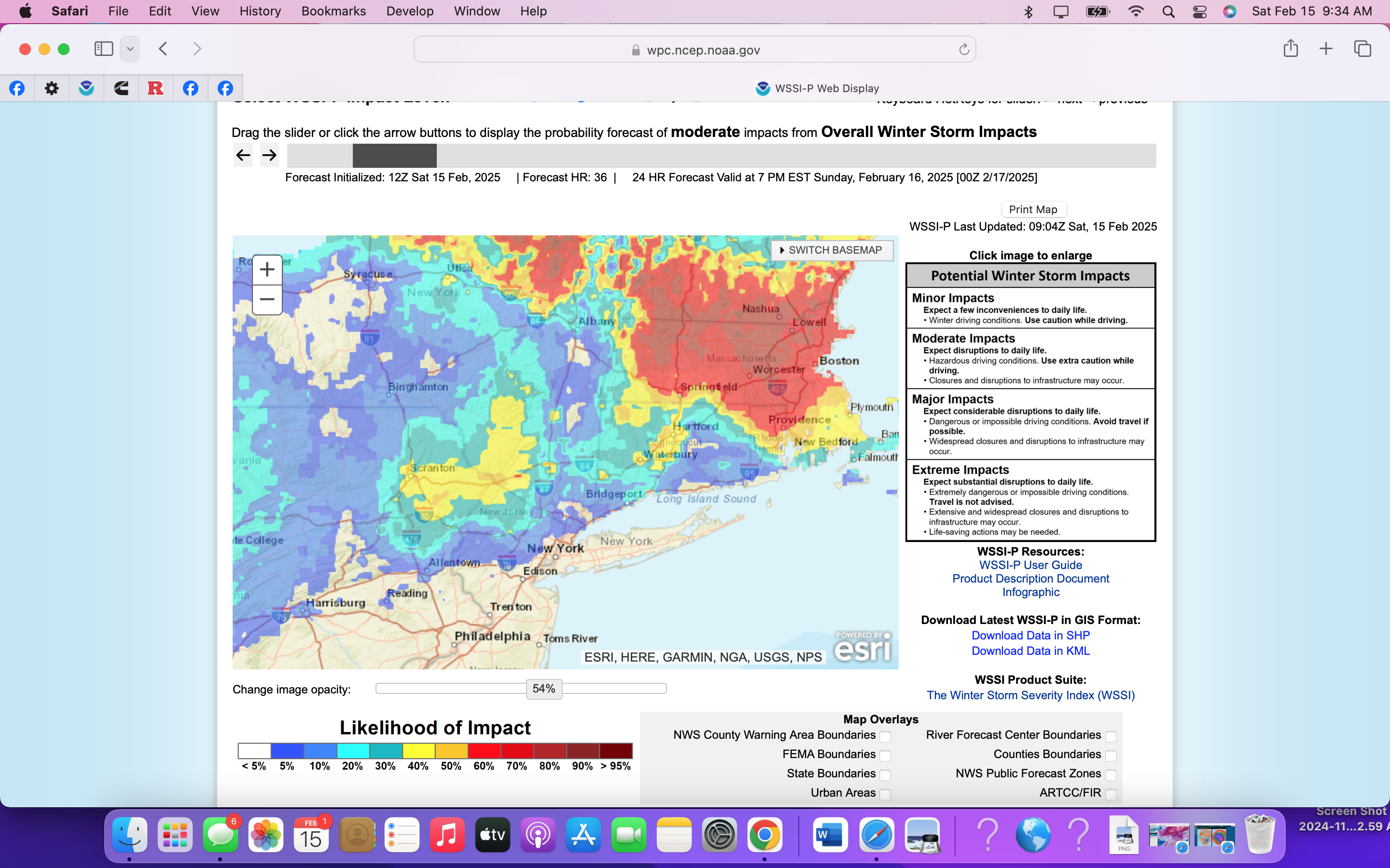
Of continuing interest to me... ECAI...06z versions says you dont get above freezing (maybe 36F-corrected at 1129AM down 10F) til between 2P-6P tomorrow... Understated event I think north of I84 and combo snow and ice is imo probably warnable but just my opinion. I just don't understand our sticking snowfall/ice accumulation criteria in mixed events. We seem not to be growing more understanding overall impact... probably don't want individual forecasters going rogue... I just dont understand. Protecting life and property is our job... at T24, we need to be thinking going for the best possible, despite criteria-not by thinking about the lowest warmest elevation appreciation of our forecast. The graphic below is the WSSI-P experimental conservative probabilities for MODERATE impact, with population-urban influencing the probs.
-
Discussion-OBS snow event sometime between 06z Thu 2/20-12z Fri 2/21?
wdrag replied to wdrag's topic in New York City Metro
fwiw:06ZEC AI west and has us in. Depends on how much this upper low closes into NYS whether its more amped like CMC /EC or weaker faster GFS/GEFS.