wdrag
-
Posts
5,045 -
Joined
-
Last visited
Content Type
Profiles
Blogs
Forums
American Weather
Media Demo
Store
Gallery
Everything posted by wdrag
-
Discussion-OBS snow event sometime between 06z Thu 2/20-12z Fri 2/21?
wdrag replied to wdrag's topic in New York City Metro
Not CP but glad it happened fairly close to CP. -
Discussion-OBS snow event sometime between 06z Thu 2/20-12z Fri 2/21?
wdrag replied to wdrag's topic in New York City Metro
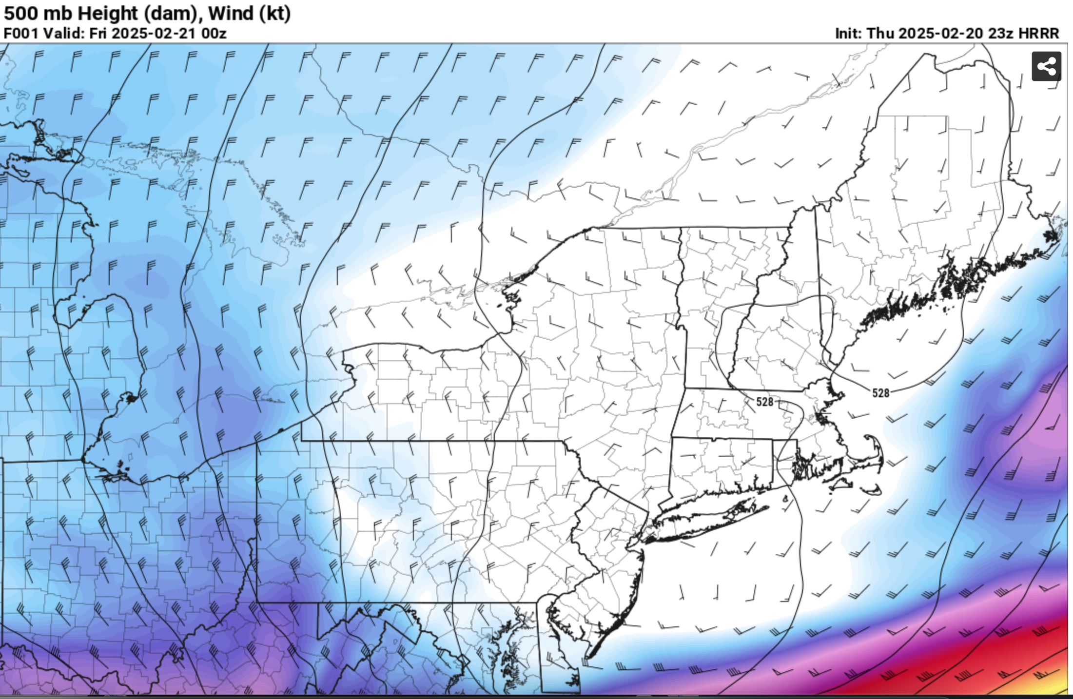
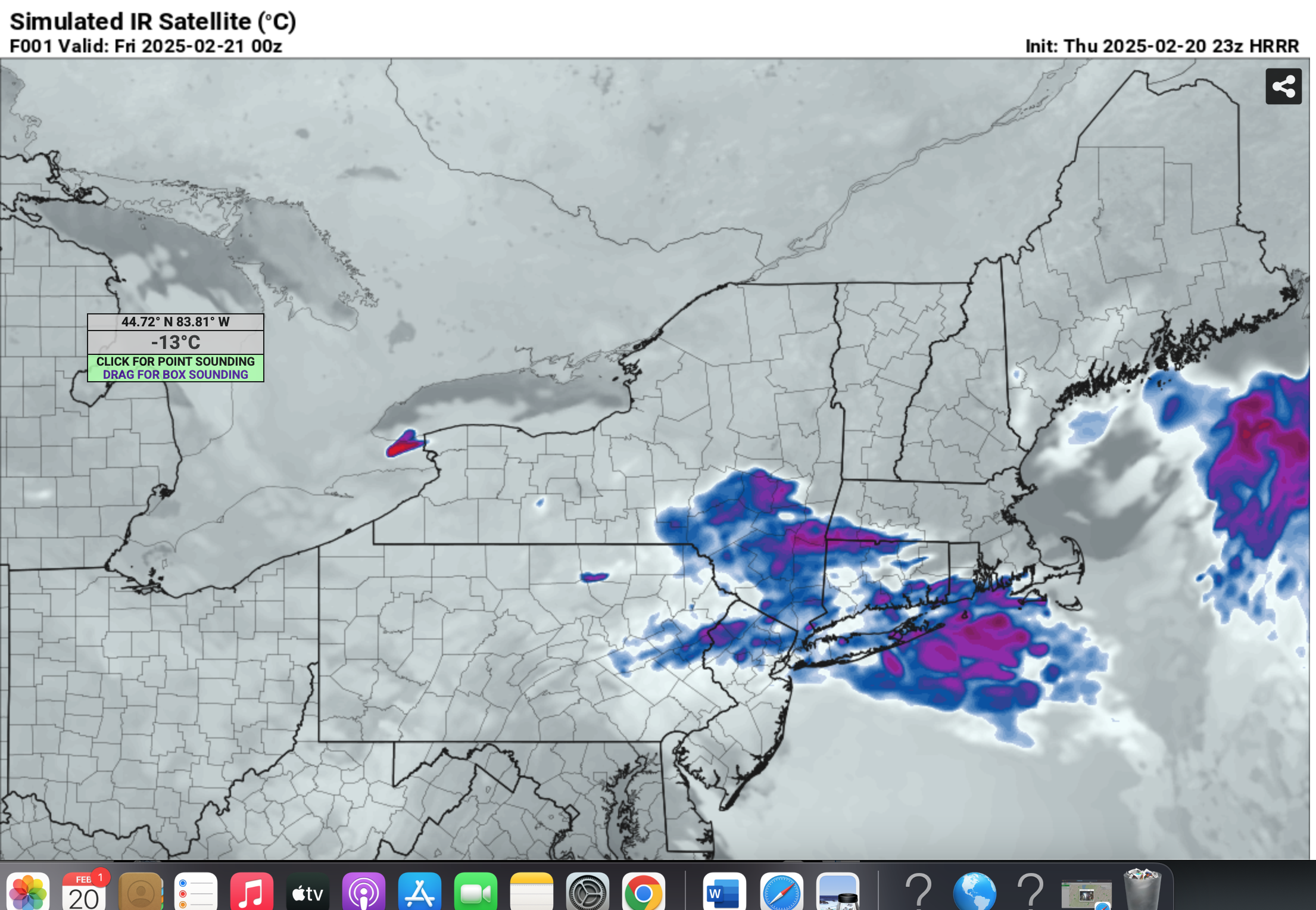
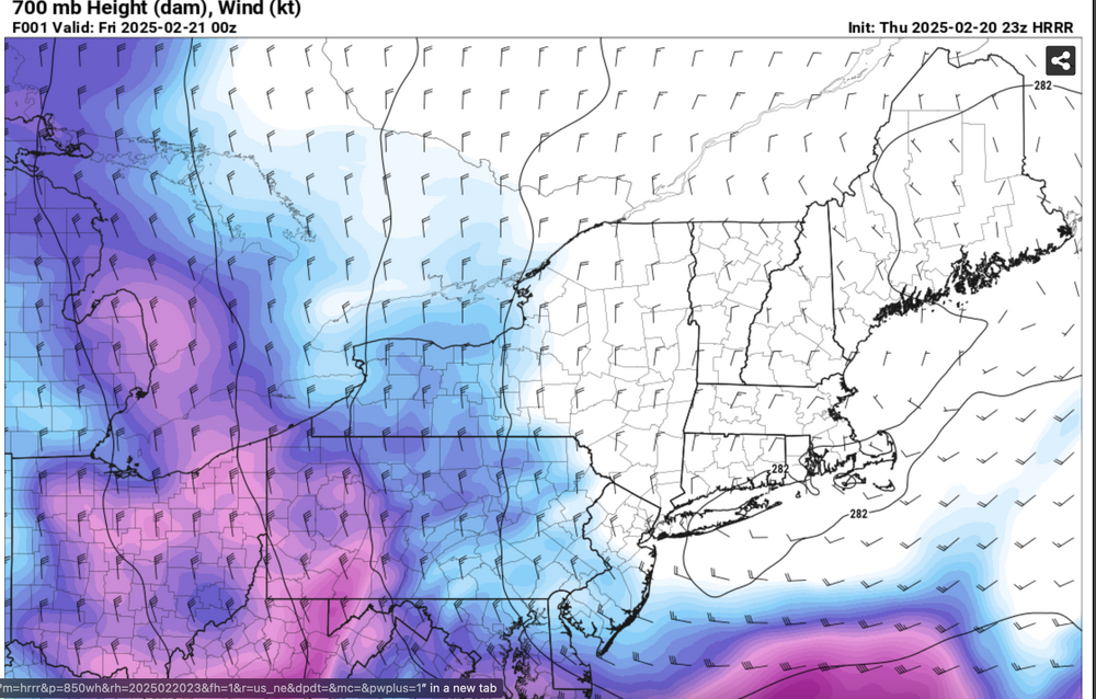
Not true IVT but certainly a nearly closed low at 500MB, with weakness west across LI at 7/8h and satellite IR suggesting seeing aiding snowfall at 7P. Also added the MODELED IR to check how good the HRRR can be at 1 hr prediction via the IR link below. https://www.tropicaltidbits.com/sat/satlooper.php?region=goes16-meso1&product=ir


-
Discussion-OBS snow event sometime between 06z Thu 2/20-12z Fri 2/21?
wdrag replied to wdrag's topic in New York City Metro
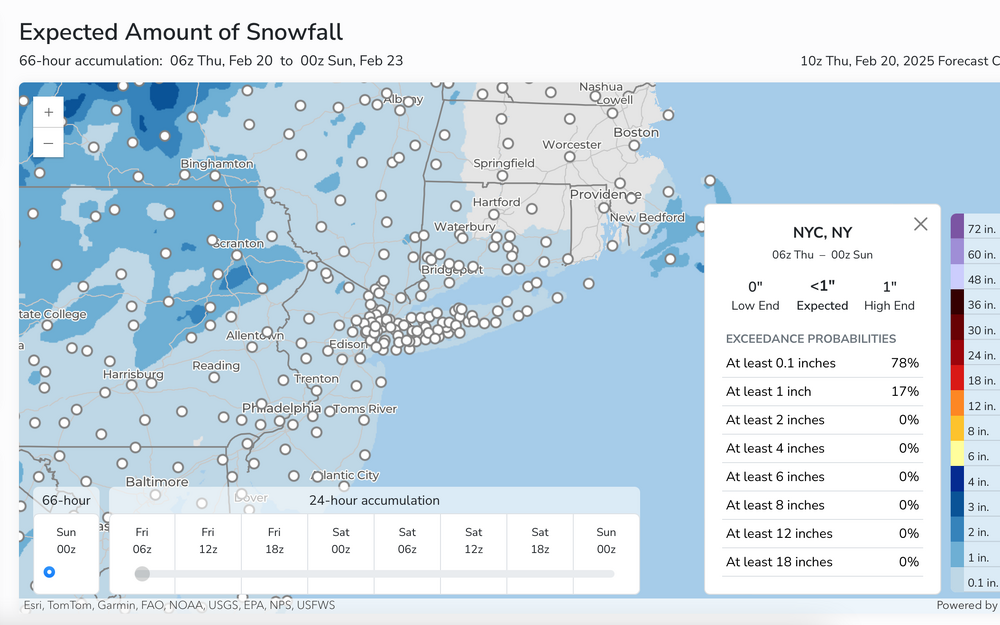
https://nyctmc.org/map I didnt see the CP amount at 7P but imo it has to be 1/2" or so... roads are soaked and shoulder snow covered-slushy per web cams above. Take a look. -
Discussion-OBS snow event sometime between 06z Thu 2/20-12z Fri 2/21?
wdrag replied to wdrag's topic in New York City Metro
Also want to point out that measuring snow out this way is problematic with the wind blowing. AND I dont believe this ASOS Trace 6 hourlies... ASOS has trouble melting snow into a reasonable liquid equivalent when temps are below freezing, especially where we were today. The ASOS experts can add info, but my seeing those vsbys in the KNYC obs (occasionally below 2MI), a trace W.E doesn't reflect what is going on, ESPECIALLY with fairly well modeled measurable. One further comment: In winter... when T-TD spreads are 20F, its difficult to get snow to reach the ground. In summer... a T/TD spread of 30F is sometimes possible 100/70 or 95/65 and severe's occur due to somewhat drier sub cloud layer and evaporational downdraft development due to the cooling in the rain column. So a rule of thumb in cool season doesn't not necessarily work in warm season. -
Discussion-OBS snow event sometime between 06z Thu 2/20-12z Fri 2/21?
wdrag replied to wdrag's topic in New York City Metro
Thanks for all the reports, Wantage NJ a wind blown slippery 0.1" and 19F. Thanks for all the road reports. Our T/T spread is still 5F so we may get a little more dusting this evening. The road reports are important for me since I saw a met saying no big deal on travel this evening. Rush hour.. temps mid 20s NYC and colder NW subs.. 511 traffic report seems to have a lot of incidents and slower travel. If I'm correct, we cant be dismissive about 1/4-1" of snow on mid 20s roads, in rush hour. Thanks for your reports. Snowfall up this way in nw SC NJ less than expected the past two days. Enjoy whatever it is... better than a complete shuit out. I'll post a summary sometime late tomorrow morning.Maybe we wont have to have any more threads for NYC this winter. For now, the Max snow axis was a nearly 300 mile southward bust on a D6.5 issuance that held serve for only a day before going south. I'll hold off on a good looking thread til D5 or 4.5 led time ---modeling picked out a good event but still has trouble D6. Like it or not, the thread covered for an event but I'd never have issued a D6 thread for 1" or less... that was not my intent. Also... you will eventually see the day when a D6 thread and its ensemble support can nail an event axis within 100 miles, if we can keep our science going. -
Discussion-OBS snow event sometime between 06z Thu 2/20-12z Fri 2/21?
wdrag replied to wdrag's topic in New York City Metro
I'll post a summary snowfall map tomorrow morning at 10AM... to close this thread at that time. -
Discussion-OBS snow event sometime between 06z Thu 2/20-12z Fri 2/21?
wdrag replied to wdrag's topic in New York City Metro
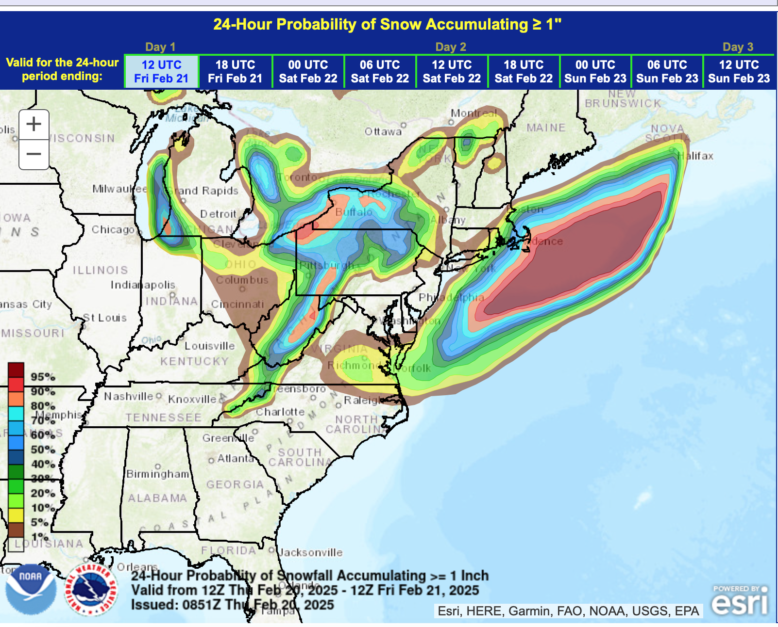
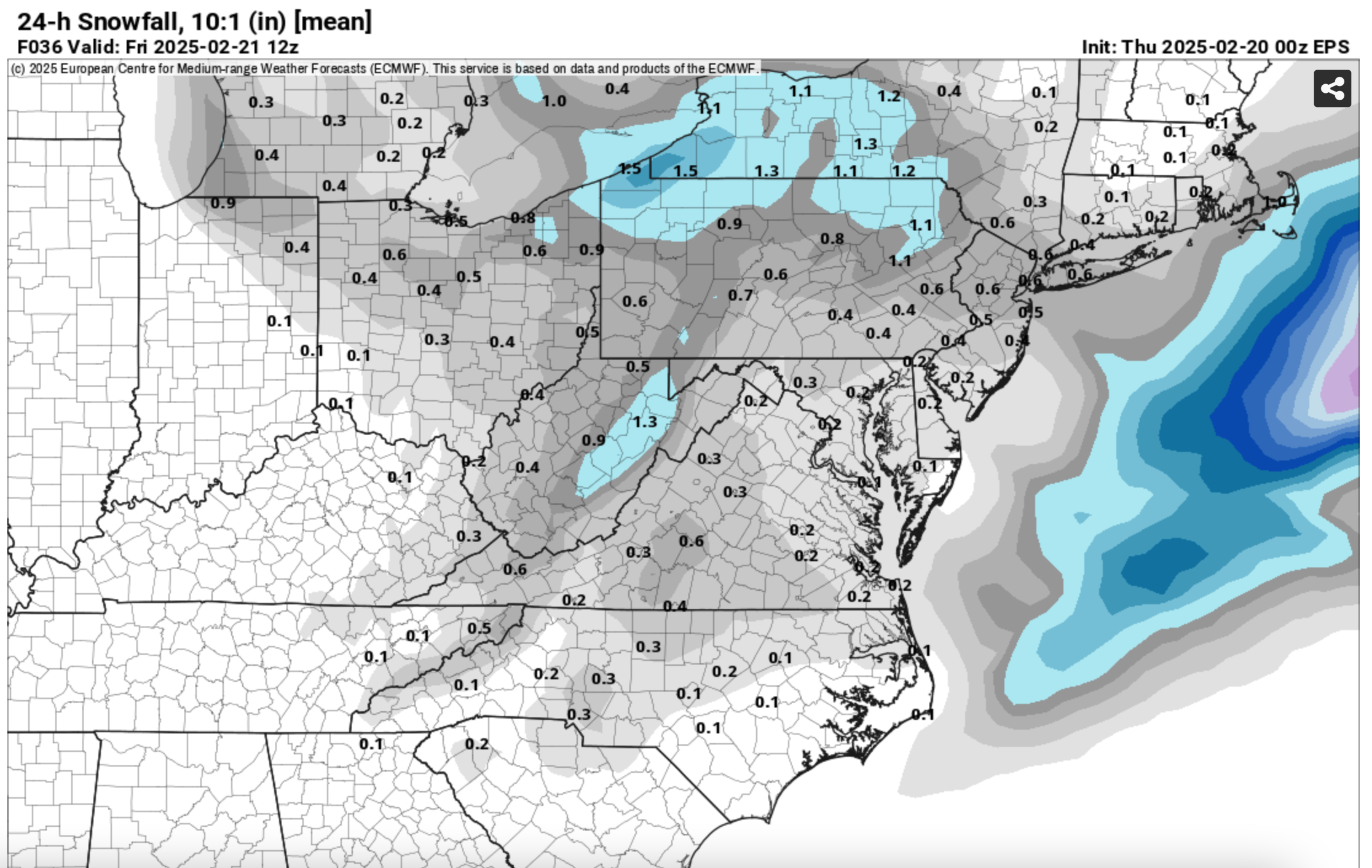
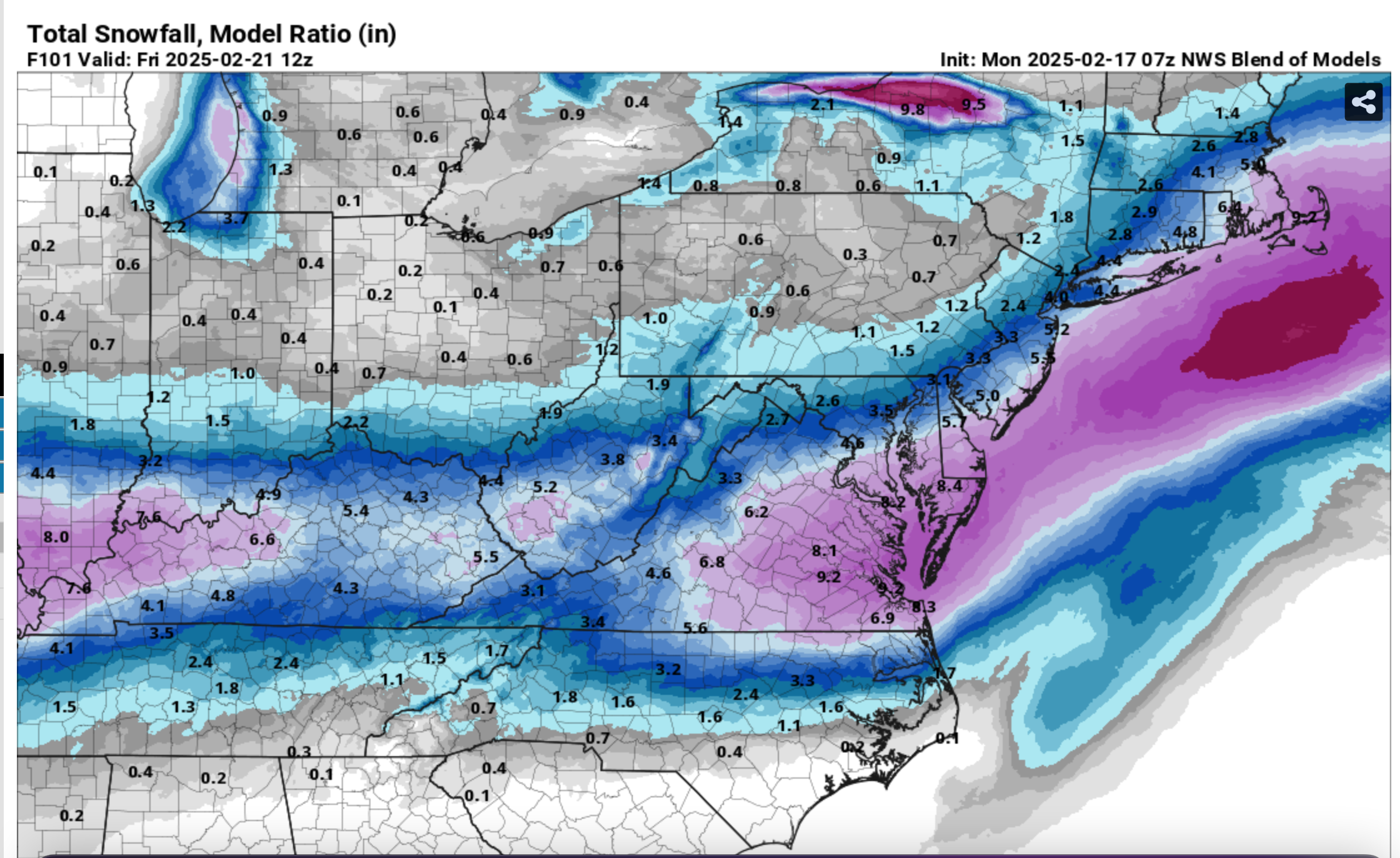
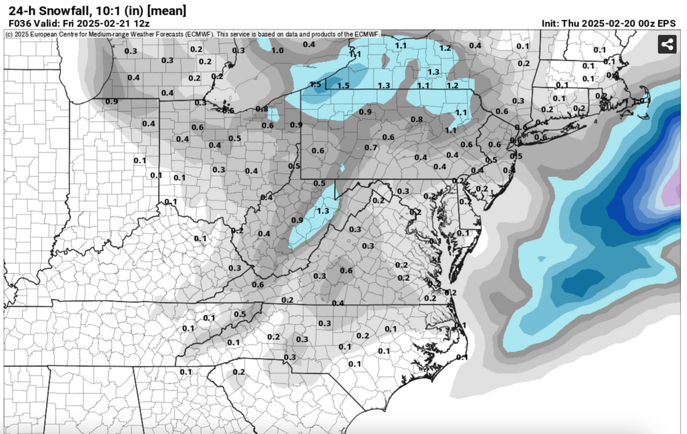
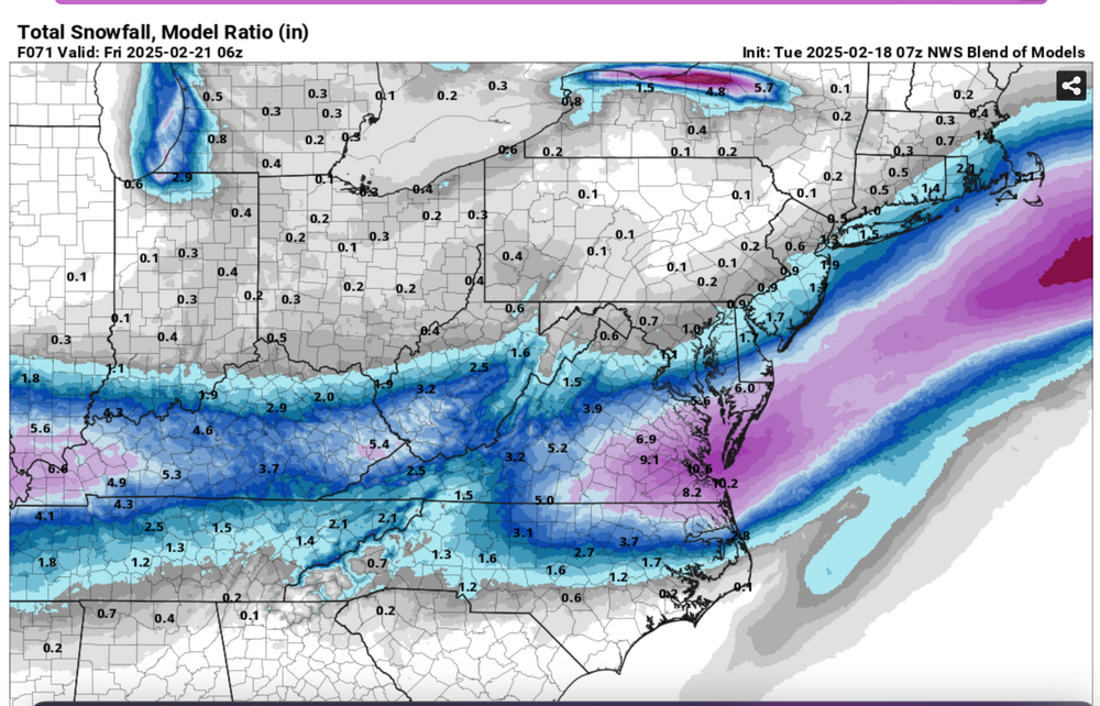
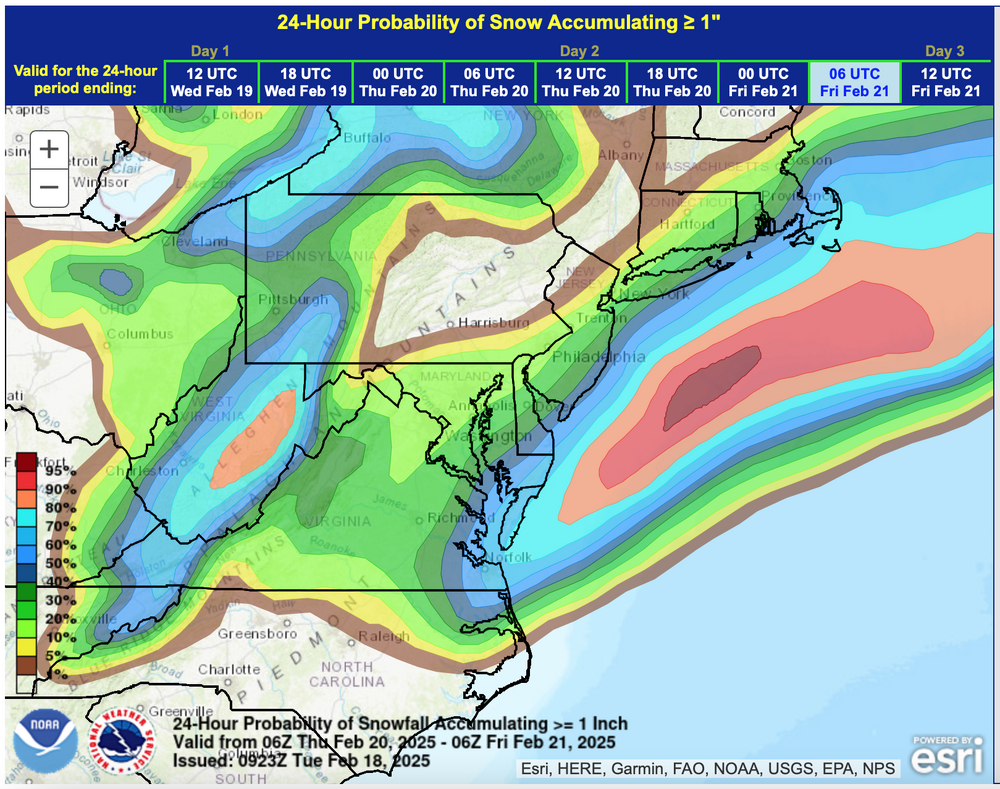
Good mornin all:: OBS will probably start here sometime midday or early afternoon. Should see a nice refreshing powder per the mapping added below. or as you see it differently but snow is coming and you'll see it rapidly expand on radar during midday as the short wave approaches through Philly northeastward. Wont surprise me that there is a short period of 3/4S- near 6 or 7PM CP and a 1/2-1" snowfall there though uncertainty exists. Let us know if sticks to the streets this evening... I kind of think in the area described below that will be slippery on untreated surfaces sometime during the evening rusk hour, especially after sunset. Winter driving habits advised, for sure side streets. Dendrites might increase from the typically cold thickness small flakes, briefly to moderate sized flakes this evening per modeled lift in the deeply saturated dendrite growth zone aided by cirrus seeding. Graphics hopefully are self explanatory including the 09z/20 NWS ensemble chance of 1" (very low a you can see) the 00z/20 SPC HREF which is optimistic for near 1" in parts of our area, 00z/20 European ensemble snowfall output and the 4AM NWS snowfall forecast.
-
Discussion-OBS snow event sometime between 06z Thu 2/20-12z Fri 2/21?
wdrag replied to wdrag's topic in New York City Metro
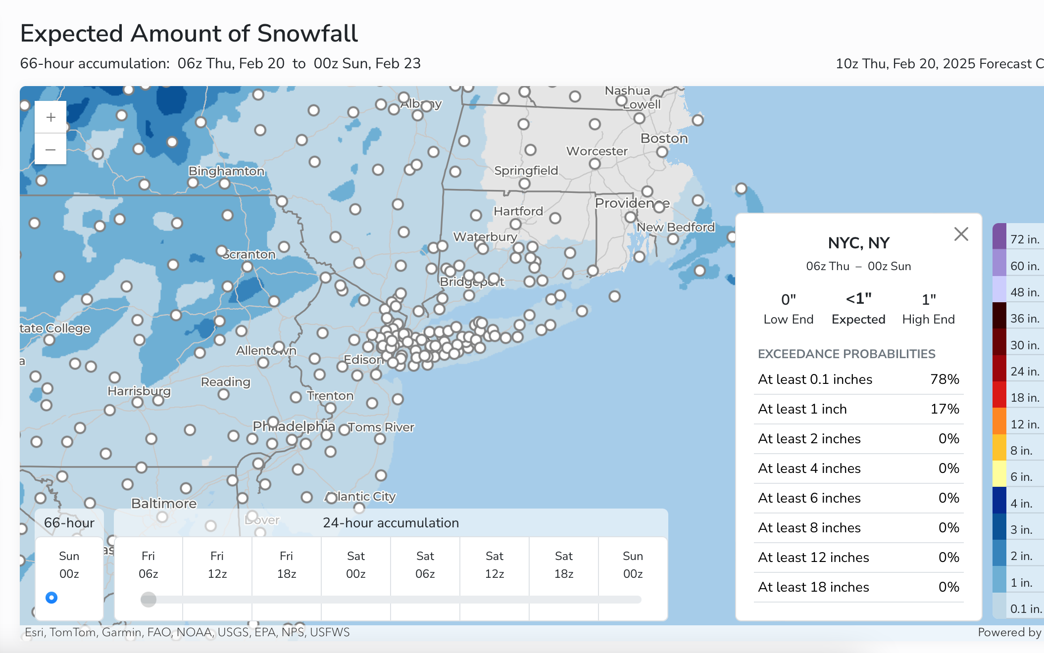
My expectation for NYC-Long Island-northeast PA, northwest NJ and se NYS Thursday: A period or two of powdery light snow or flurries between Noon and midnight that may slow the Thursday evening commute. Amounts generally under 1 inch but isolated 2" amounts possible in the Poconos and also eastern Long Island. If it does snow steady for 2-6 hours, then road treatments will be necessary. Uncertainty on amounts as most modeling is a slight dusting but the unusual recent and unfolding winter situation may produce somewhat more than a dusting. I've provided my explanations yesterday. If the NAM and RGEM fade on the 500MB low, then I'm wrong on placing so much value on the developing closed low aloft and weak IVT. So while the big storm is far to the southeast....as others have noted, worth monitoring the mesoscale developments for tomorrow. -
Discussion-OBS snow event sometime between 06z Thu 2/20-12z Fri 2/21?
wdrag replied to wdrag's topic in New York City Metro
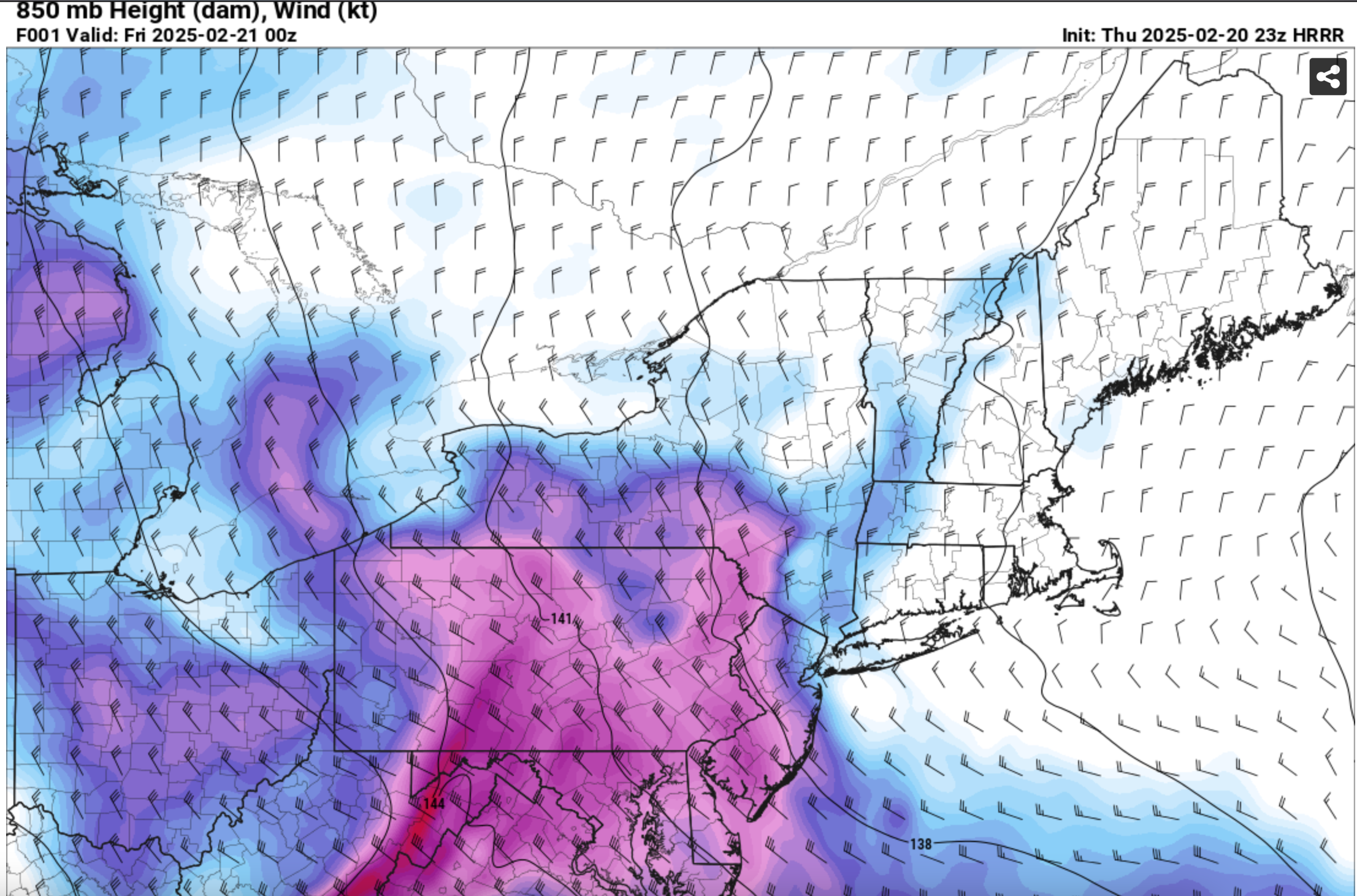
What I think of as a 2-6 hour snow event between 3PM and 11P in much of the NYCsubofrum, which is gradually becoming accepted in bits and pieces by Global ops (not specialized in smaller scale), but not yet accepted by the Ensembles; should be related to considerable 850 MB vorticity in the inverted trough back from the ocean low, pretty deep FGEN 850-700MB between I80 and I84 with the saturated layer interestingly enough south of the FGEN region. There will be seeding from cirrus aloft, and a deep layer of moisture with the DGZ almost down 875MB. I can even see minor ocean effect on northerly flow off LI sound on the east end. So if there is sunshine, it's only Thursday morning. This is a deepening 500MB low now starting in the northern Plains and modeled to have a nearly 200M 12 HR 5H HFC crossing the Delmarva Thu aft. Closed lows aloft spell trouble... its not yet connecting directly to the ocean, probably cant capture it because its too progressive but there is some westward room for development at 850MB. We'll see what happens, if anything. -
Discussion-OBS snow event sometime between 06z Thu 2/20-12z Fri 2/21?
wdrag replied to wdrag's topic in New York City Metro
I'll have to be patient... Should the 18z/18 3KNAM and RGEM verify as cyclically modeled... what is that 0.5-1.5" powder going to affect your Thu evening commute with temps during any snow generally mid 20s, possibly dropping into the lower 20s. Again if it snows. Snow ratio modeled 11 or 12 to 1 NYC and near 14 to 1 and west... taking the more conservative NAM 3K. Wont surprise me to see 3/4S- NYC CP around 5 or 6P. IF its still on in tomorrows modeling we'll look at snow growth. Definitely very cold thickness so typically that's a smaller flake unless flavored by DGZ growth. The ULL at 5H is nice... looks like a 150-170 12 HR HFC crossing the Delmarva Thu afternoon. For now... I sit tight on the thread as is.. and we'll see if snows as I think it will, albeit minor though with my first pgh caveat....slippery stretches that would need salting If the 5H ULL weakens in future modeling over our area, then it is done=no sno and all this has been for naught. Best I can do. Will check in lager tonight or tomorrow if snow is still a player. If not a player... I did my best to play it cautious. -
Discussion-OBS snow event sometime between 06z Thu 2/20-12z Fri 2/21?
wdrag replied to wdrag's topic in New York City Metro
One thing that is somewhat evident to me in FEB... eastern LI has been doing RELATIVELY well. Seems like that may be the case again. Watching waffling minor changes in global ensemble qpf so noise for now. -
Discussion-OBS snow event sometime between 06z Thu 2/20-12z Fri 2/21?
wdrag replied to wdrag's topic in New York City Metro
So the 09z SREF is less and close to the BOM. We are 48-60 hours out. Could be nada but I dont think so with the RGEM/NAM still on board and all ensembles have fragments. If we lose the NAM and RGEM then it's done for me in NYC. I saw the comment on dew points... true if its 20 or greater spread, then nothing. It may take a few hours to moisten and that could waste it... Right now I'm at a 13F spread. Modeling does not show a Sunny Thu. they tend to a 22z/20 snow opportunity with minor ...repeat very minor snow growth in DGZ. 12z HRRR may have an idea if DC-BWI gets some light snow by 12z Thu. (48 hr version). In any case, go do your life... check back tomorrow.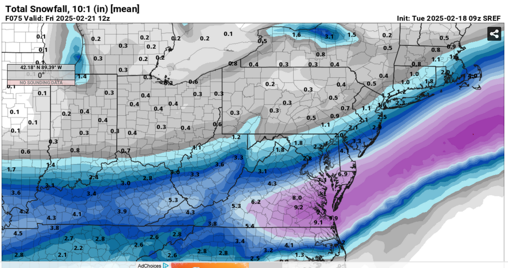
-
Discussion-OBS snow event sometime between 06z Thu 2/20-12z Fri 2/21?
wdrag replied to wdrag's topic in New York City Metro
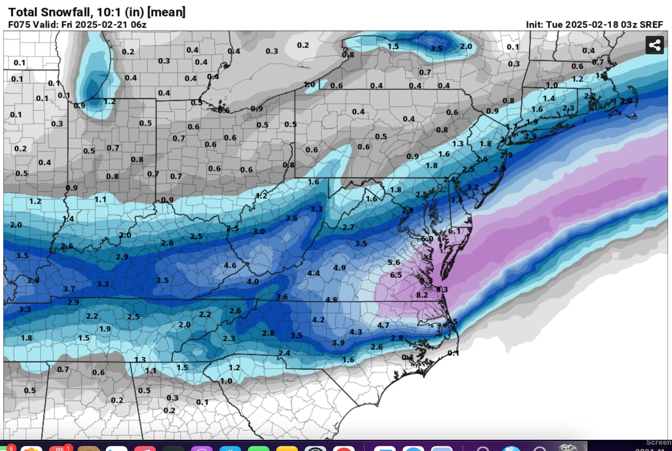
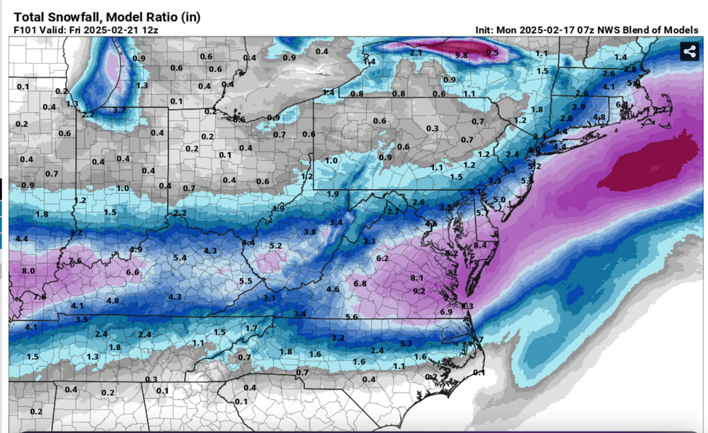
OK... Lets says ne PA/nwNJ/seNYS...how about about a 30 mi radius of High Point NJ on the nw point. Current modeling projects Trace-1/2" there, then out to the Montauk and whatever you would like in central NJ... can we use I195??? Your call, and that maybe where we may see 1-2" of powder. Added a few maps.. we know the big one is gone but the strength of the upper low should produce some high ratio powder snow showers or periods of snow in the 10A-10P time frame for portions of the NYC subforum... another minor or very minor event. This past weekends storm (some of the worst icing seen here in nw NJ in quite some time- I do recall a similar -worse icing event in the Poconos Feb 3 2022, and a bad one in the Philly area in prior decade) and the current bitter cold speak of a somewhat unusual pattern ion strength. Am not selling anything short in what I feel is a somewhat less than benign pattern. Don't want anyone wasting there time when taxes are soon due and work needs be done cleaning up debris.
-
Discussion-OBS snow event sometime between 06z Thu 2/20-12z Fri 2/21?
wdrag replied to wdrag's topic in New York City Metro
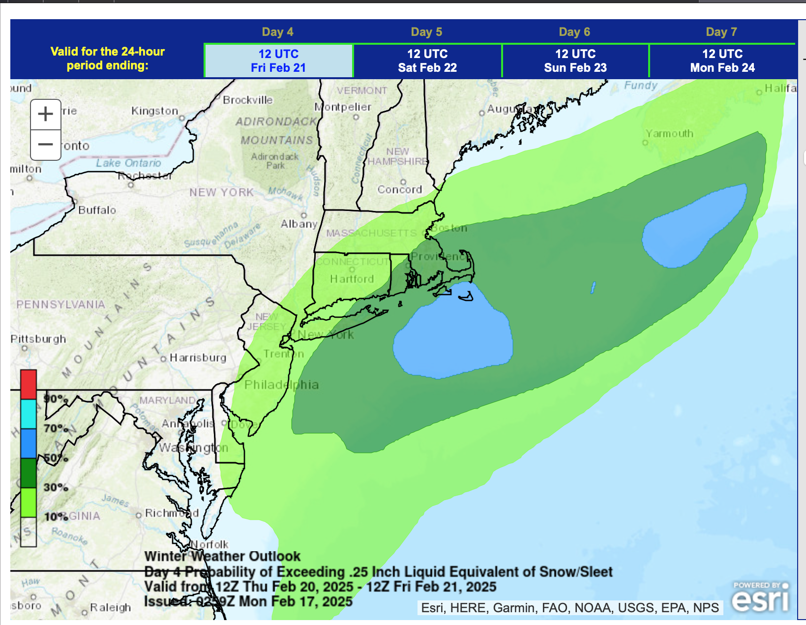
7PM 2/17/25: adjusted headline to narrow the timing goal post of what has become a much more uncertain event since initially proposed...even with the option of no snow. This despite a strong short wave passage Thursday evening. The GEFS still closes a low through PA while the EPS has weakened to an open - less ominous progressive short wave trough with no significant 850 MB onshore circulation. The 15z/17 SREF, 18z/17 NAM and 12z/17 JMA are the only models with any significant hope for snow as the globals have largely faded southeast since thread inception. The apparently lagged average BOM and 12z/17 WPC still maintain an opportunity for a period of light snow (1/2-4" nw to se on the BOM). -
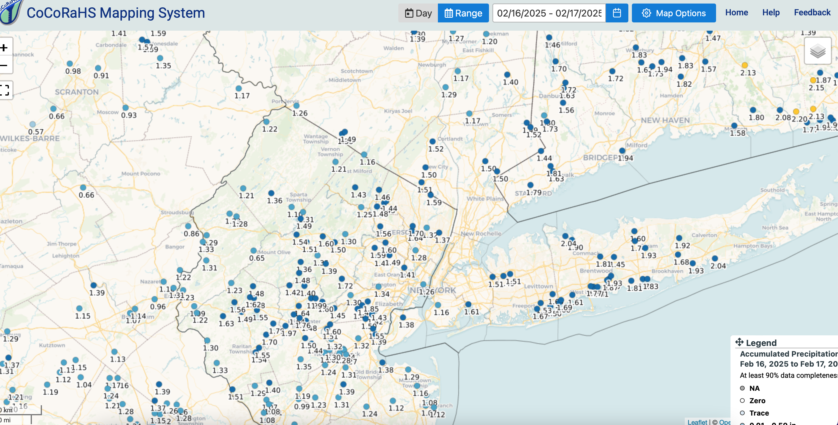
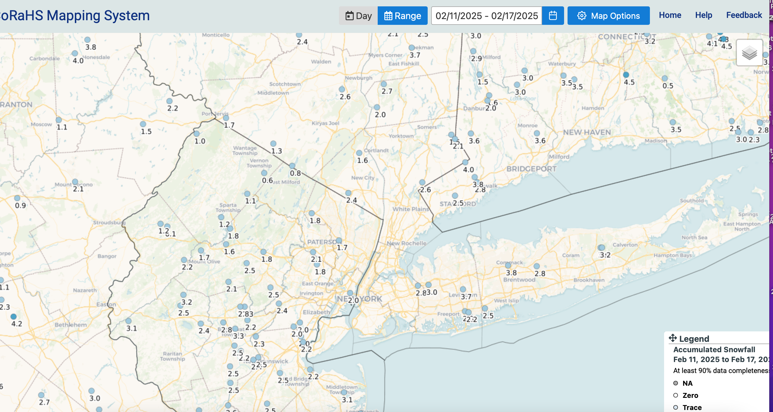
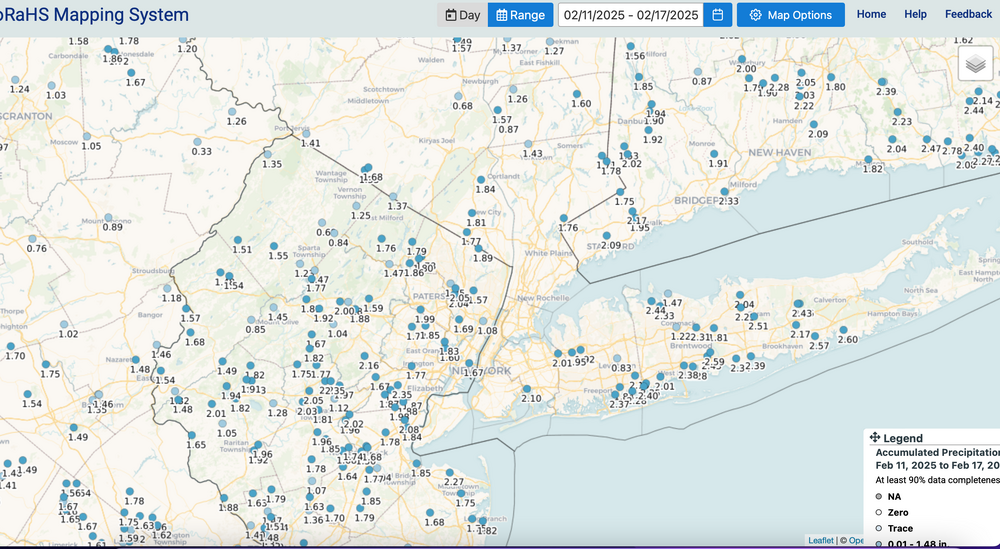
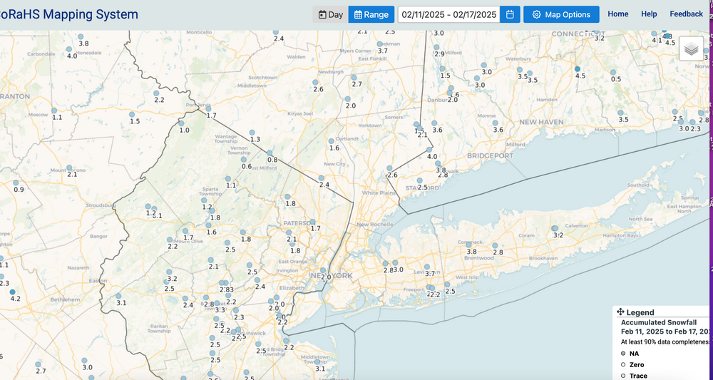
OBS-Nowcast Noon Saturday 2/15-Noon Monday 2/17
wdrag replied to wdrag's topic in New York City Metro
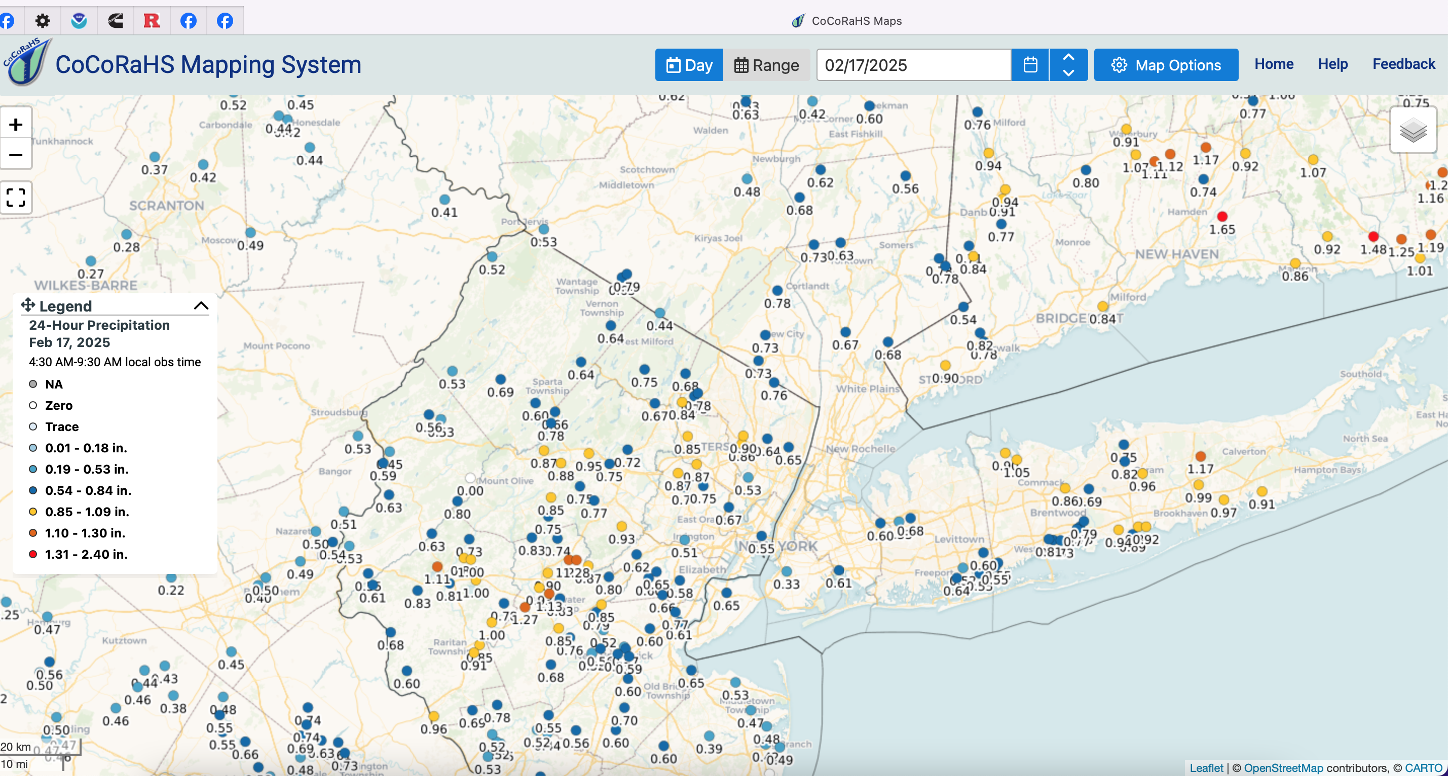
Rainfall yesterday and the two day.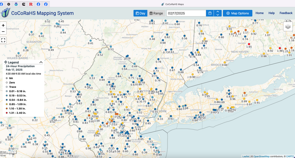

-
Snowfall this 5 day period... short of expectations but two separate minor or every minor events. as well as rainfall 2/11-16.
-
Discussion-OBS snow event sometime between 06z Thu 2/20-12z Fri 2/21?
wdrag replied to wdrag's topic in New York City Metro
Willl probably adjust the start time of the thread around 730PM...delay 6-12 hrs from s to n. I dont understand it either, but the BOM actually increased a bit at 19z. Not sure if its too reliant on the SREF (Nam based)?? So I've seen most of what you've seen from 12z and 18z. Japan model which I check everythday and sometimes its better than the UK... which probably imo doesn't say that much but we're obviously edgy at this 72 hour stage, so I'm not canning-Japan not full on but the potential upper low is intriguing. Yes I saw the 18z NAM and its 3K cousin. Nothing definitive in this run except its not fading like the globals. My point in the this run up to the ocean storm... the 850MB wind field is wide-open Wed night-Thu morning for offshoe location and being stronger then the general broad weak 15 kt split structure its showing. A little more time before you all are correct and I held on too long against the 30 hr cyclic trns. . No lessons learned since it was stated upfront on P1 but would disappointing if nothing happened here. My feeling is whatever happens Cape May, happens Montauk and we titrate down to northwest from there. -
OBS-Nowcast Noon Saturday 2/15-Noon Monday 2/17
wdrag replied to wdrag's topic in New York City Metro
52-53kts lsometime last 3 hours LGA-HPN, also DCA-ORH. Makes you wonder about advy vs warning. -
Discussion-OBS snow event sometime between 06z Thu 2/20-12z Fri 2/21?
wdrag replied to wdrag's topic in New York City Metro
I am certain of a period of light snow Thursday.. NAEFS support and soooo much room for development at 850MB off VA as the upper low slowly becomes neutral.in its end approach to PA We're 4 days out. I am one to make an initial call... and stay with it. WHAT IF THIS COMES BACK AND how does the NWS explain. Once the cat is out of the barn so to speak, you stay with it, til it goes away, at least for decision makers. That I why the NWS is very conservative eve beyond 60 hours. Here in AMWX most are looking at models and wind shield wiping with every sweep and you can do that, with no impact except on the board. -
Discussion-OBS snow event sometime between 06z Thu 2/20-12z Fri 2/21?
wdrag replied to wdrag's topic in New York City Metro
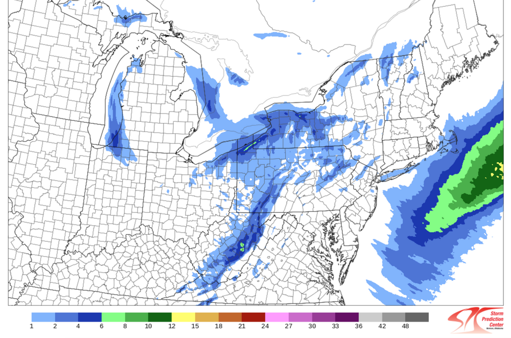
The top map if you read the ending time is 7AM Thursday, the next one should say 24 hours ending 7AM Friday. -
OBS-Nowcast Noon Saturday 2/15-Noon Monday 2/17
wdrag replied to wdrag's topic in New York City Metro
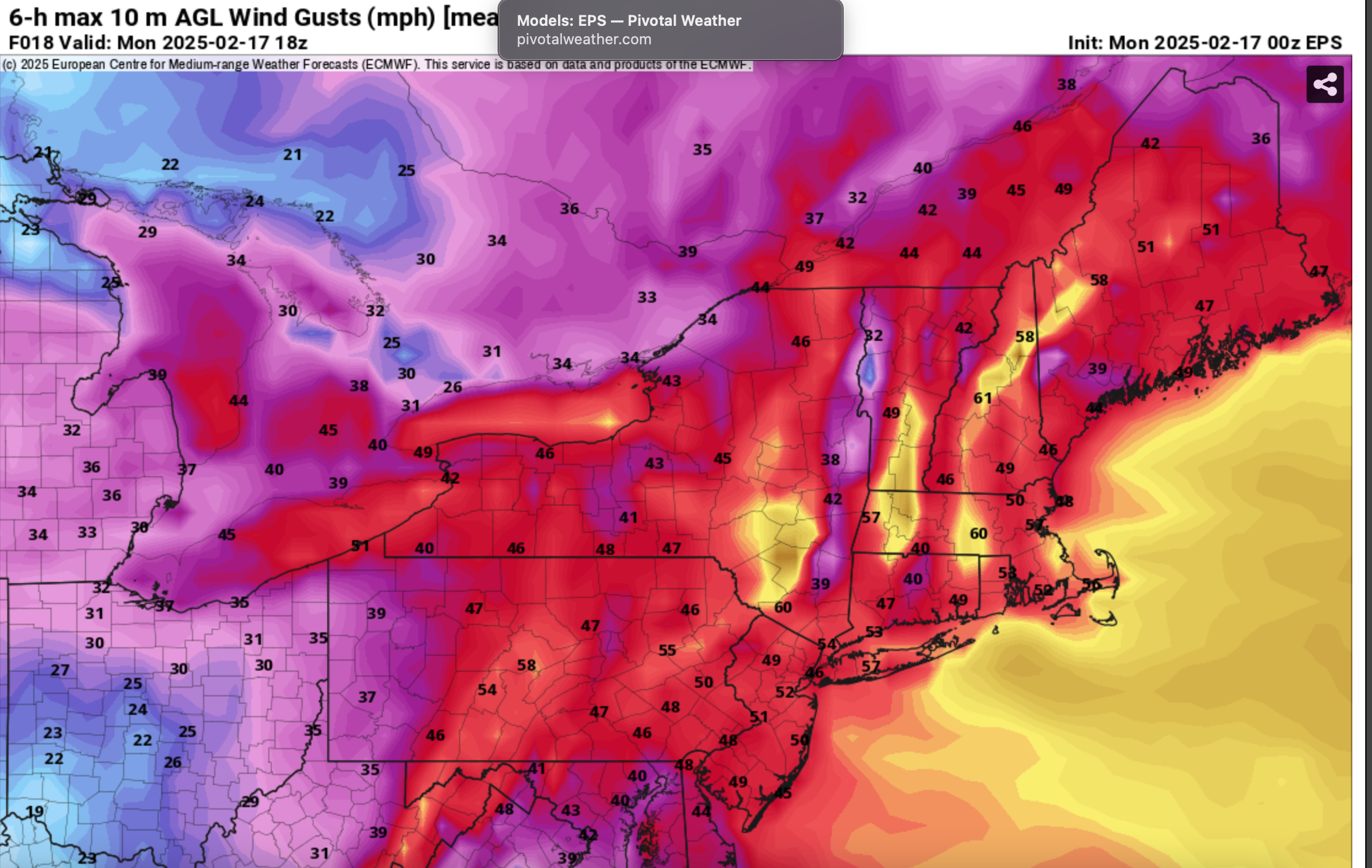
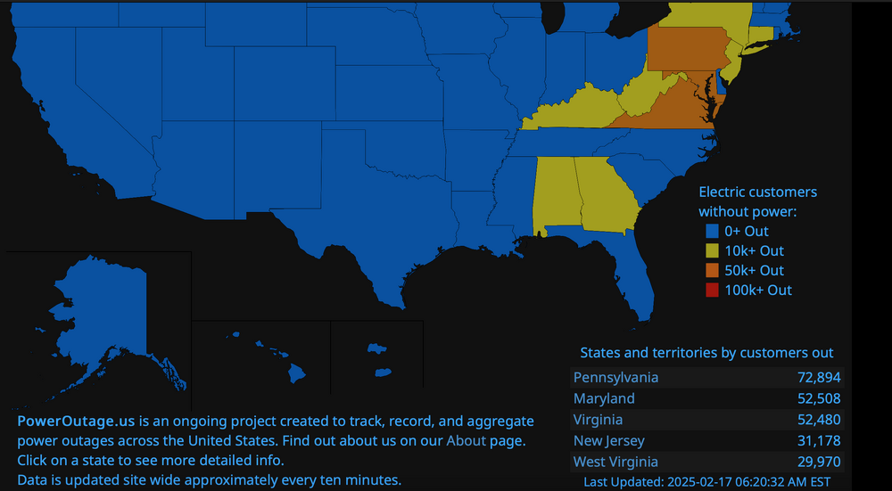
Attempting to add CoCoRaHs rainfall and snow fall for the past week, and monthly totals sometime between 10A-Noon. For now added power outages at 630AM and projected EPS wind gusts 7A-1P. Hope you have or get your power back soon. We lucked out in most of Wanatge last night, the spike in temps to the mid 30s helped the wind blast ice cycles off the trees, preventing much more of a problem. Not so lucky in nearby areas.
-
Discussion-OBS snow event sometime between 06z Thu 2/20-12z Fri 2/21?
wdrag replied to wdrag's topic in New York City Metro
No change in original thread thinking from P1: I see the "put it to bed" commentary... so you need not check back. Upper air system looks too strong with a closed low developing to have this system miss us. I've added the BOM and WPC ensemble guidances. I'm still in for 2-6" of powder from 0.1 to 0.4 liquid northwest to southeast across the NYC subforum. It's possible that I'm wrong but pattern recognition of the unfolding eastward translation and intensification of the modeled low pressure system aloft argues for maintaining consideration of a snow event, even if the primary goes out a little far. There could be some sort of inverted trough back to the coming upper low. BOM may come down in the next cycle or two due to missing some of the 06z/17 guidance but very hard for me to see a miss with the projected closed 5H low across PA-NJ.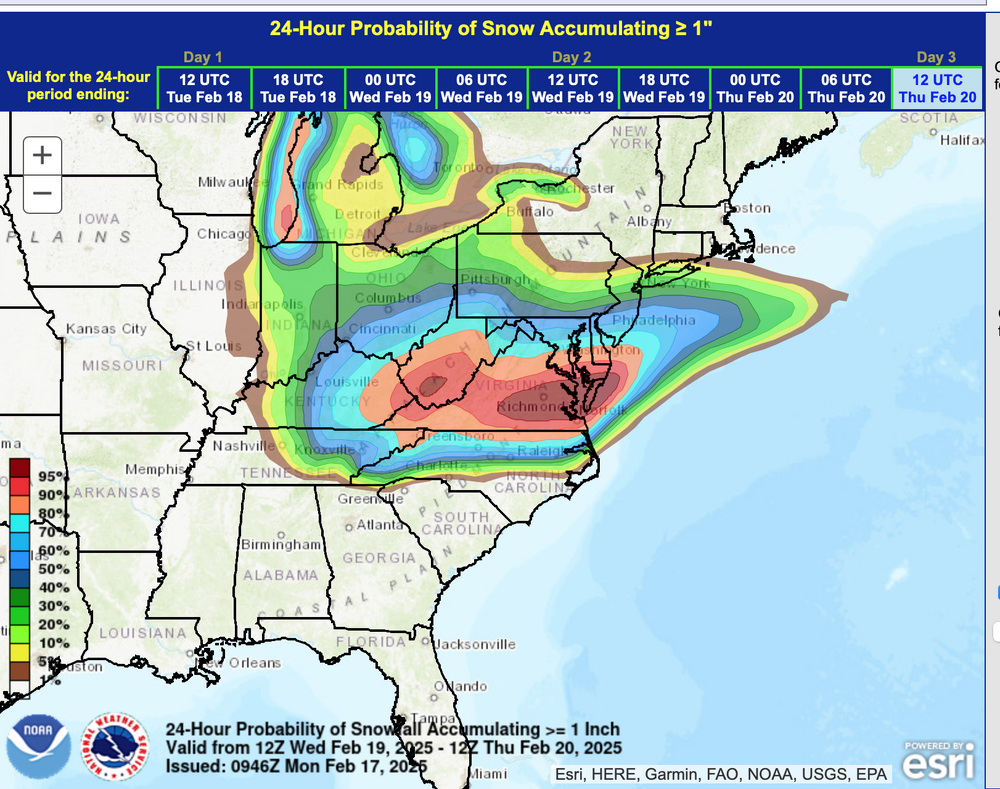

-
Discussion-OBS snow event sometime between 06z Thu 2/20-12z Fri 2/21?
wdrag replied to wdrag's topic in New York City Metro
I stay with 2-6 for the NYC subforum... trends are down but not done and could return... details tbd once the upper low forms in the midwest-great lakes. Steady is best despite the ups and downs of being a hitter... you cant get too high nor too low and yet provide a good service for the customer. Yes, it may miss but I think the snow likely Thu was and is still a good call for NYC. Sweat it out.. Over and over again, no one promised a big hitter... just the more likely period of accumulative powdery snow. I may be offline for 12 hours due to baby sitting and or power loss. Have a good night all, if you still have power. -
OBS-Nowcast Noon Saturday 2/15-Noon Monday 2/17
wdrag replied to wdrag's topic in New York City Metro
I see NYC made 47 around 23z... kind of late in the day. Ditto here we made 37 in Wantage here at 7P. Too late to prevent damage. I think the heliport in Manhattan made 50. It's raining ice off the branches now here in Wantage and glad we have had the 70 MPH gusts, at least not yet. May take quite a while to get power back once its off, due crews spread a little thin in the many east coast states where power is out. This may be my last post for a day if we lose power. -
OBS-Nowcast Noon Saturday 2/15-Noon Monday 2/17
wdrag replied to wdrag's topic in New York City Metro
SPC HREF FIRE MIN wind gust is what I use for the following. 32.0F here in Wanatge. I think we have about 5 hours (til 7 or 8 tonight) to get rid of our remaining ice, probably too late for some spots in se NYS/W of the CT River and SPC HREF FIRE min wind gust increase rapidly 5P-8P, with worst of the wind tomorrow morning. Power outages continue to increase and it looks to me like pretty big problems coming to e NYS, ne PA, nw NJ and w of the CT river in SNE. Best I can do... not an absolute but we'll be busy cleaning up tomprrow and Tuesday.