wdrag
-
Posts
5,045 -
Joined
-
Last visited
Content Type
Profiles
Blogs
Forums
American Weather
Media Demo
Store
Gallery
Everything posted by wdrag
-
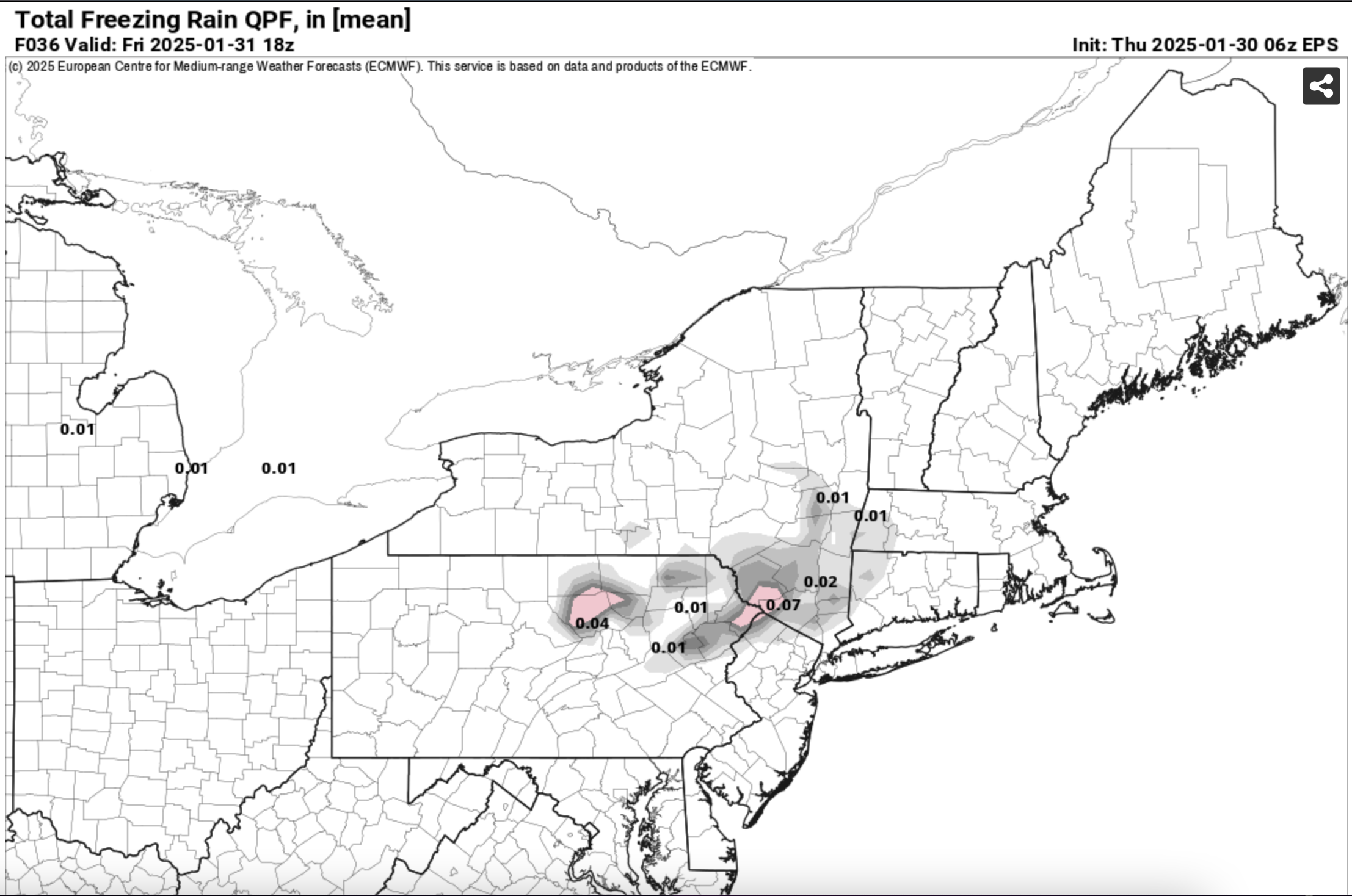
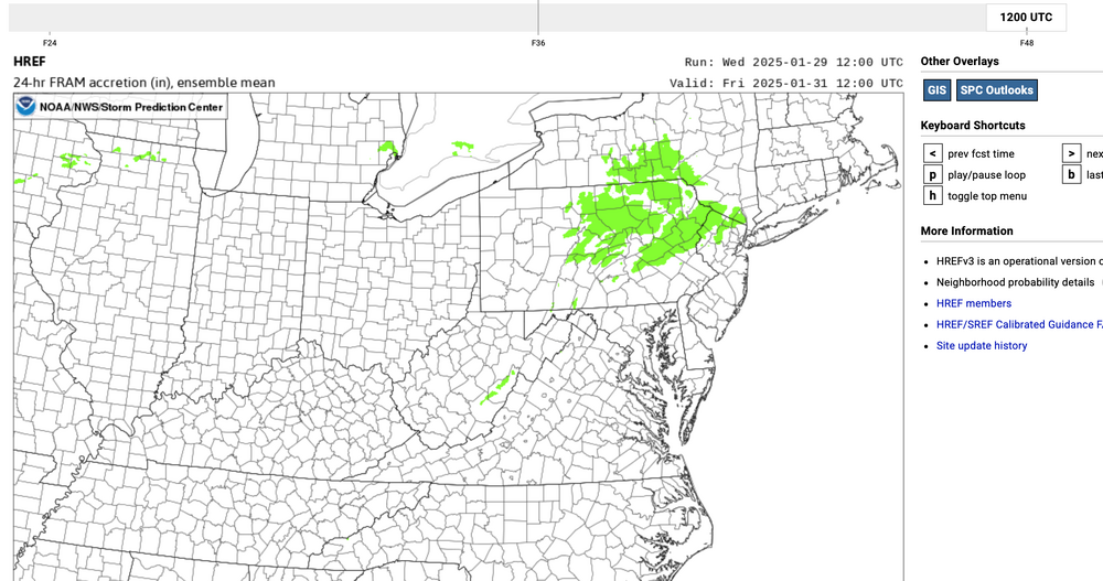
18z/29 RGEM/EC now starting as snow se NYS Fri morning and as it see it, some model trends are continuing south. I dont buy the ICON far north, nor the NAM. Thinking GFS/EC/CMC blend... and will watch how this steadies or sinks a little more on Thursdays cycles. I know snow is the winter prime interest here, but ice is in the mix as the 21z/29 ensembles suggest, mirroring the previously posted 12z/29 SPC HREF ice graphic.


-
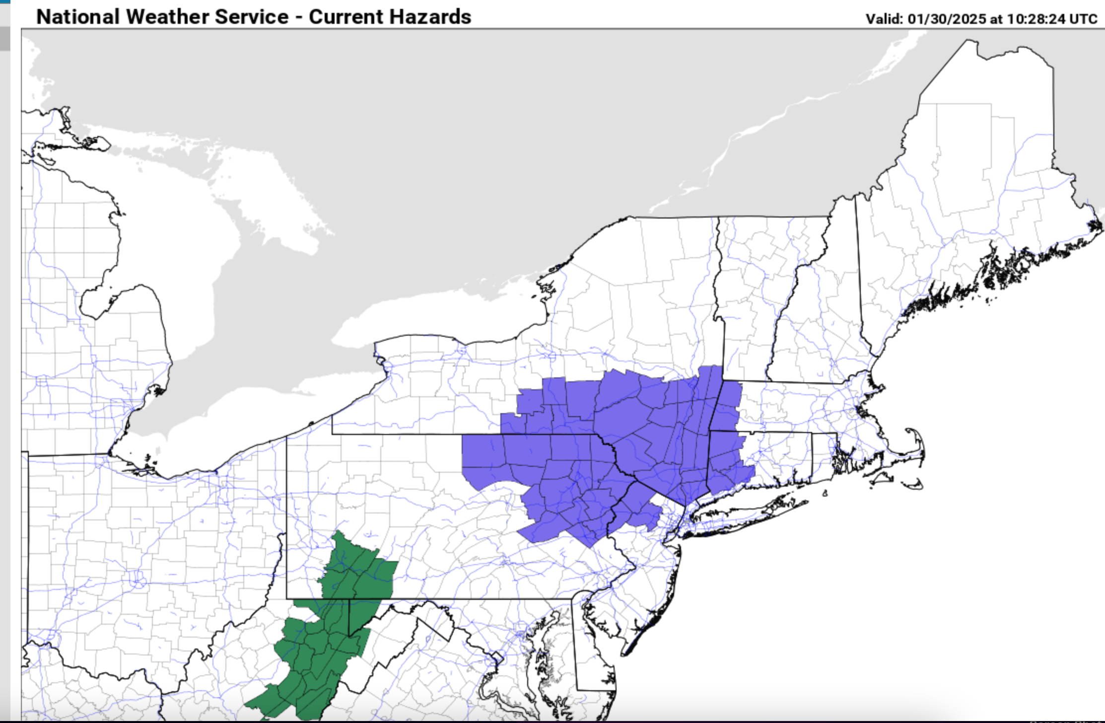
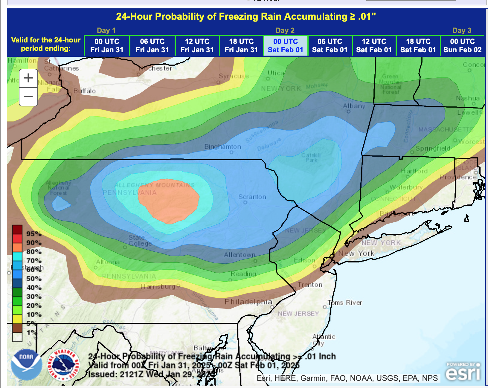
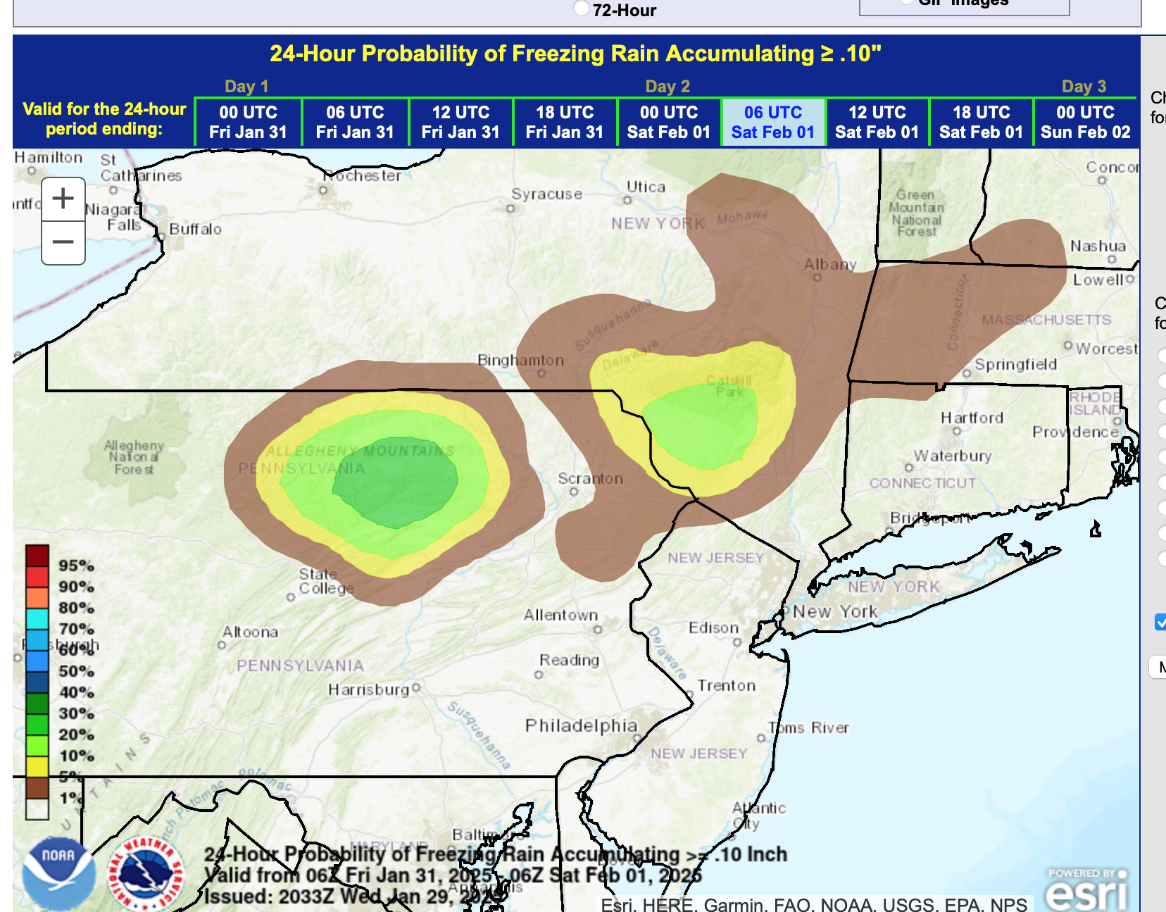
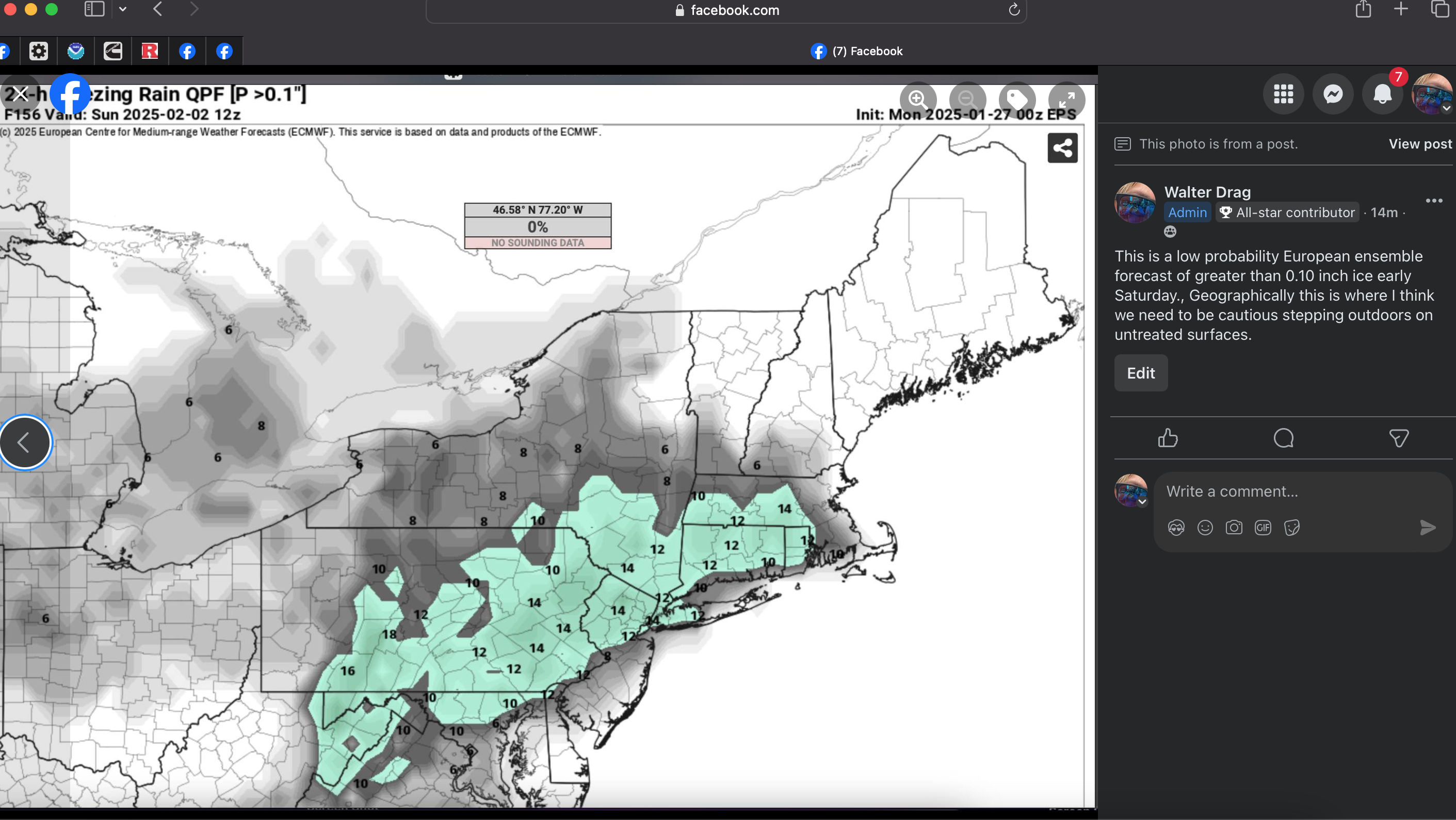
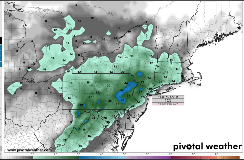
Anyone heading into nw NJ-I84 corridor of NYs-CT-MA Fri-Fri night should be alert for icing on untreated surfaces. NWS probs for .01 zr in that area >60-70% and now a 20% chc of .1 glaze in some high terrain locations. Additionally, modeling seems to be gradually shifting south since 00z/29...sfc low not going across NYS but instead near I80 and EPS snowfall axis slipping a bit s now into MA. Still far away from us but still worth monitoring.Attached glaze potential near sunrise Friday.
-
Headline change at 730AM Wed 1/29 for failed 7 day lead time on wintry accums NYC-LI. Discussion-OBS Jan 31-Feb 2 rain, potential minor interior impact mixed wintry events, mainly Fri Jan 31, Sun afternoon-eve Feb 2. Failed 7 day lead time LI winter impact. Events accelerated 18 hours and warmer-further north than modeling posted in this initial 1/26 thread indicated. Wrap up hat happened will post Monday Feb 3. P5 shows the NAEFS speed change. Ensembles were generally a little far south except possibly the CMCE. The EPS freezing rain probably had this pretty good, just maybe a little too close to NYC. I dong like failing but in advance, thought it best to call it like it looks to occur. Still room for further south-colder solution but unlikely much wintry impact on NYC-LI. For those who wish, continue to monitor and post here on whatever occurs. I think the NYC CLI (and surrounding cli sites) rain and January place in qpf history can eventually post here if you wish, or in the Jan thread.
-
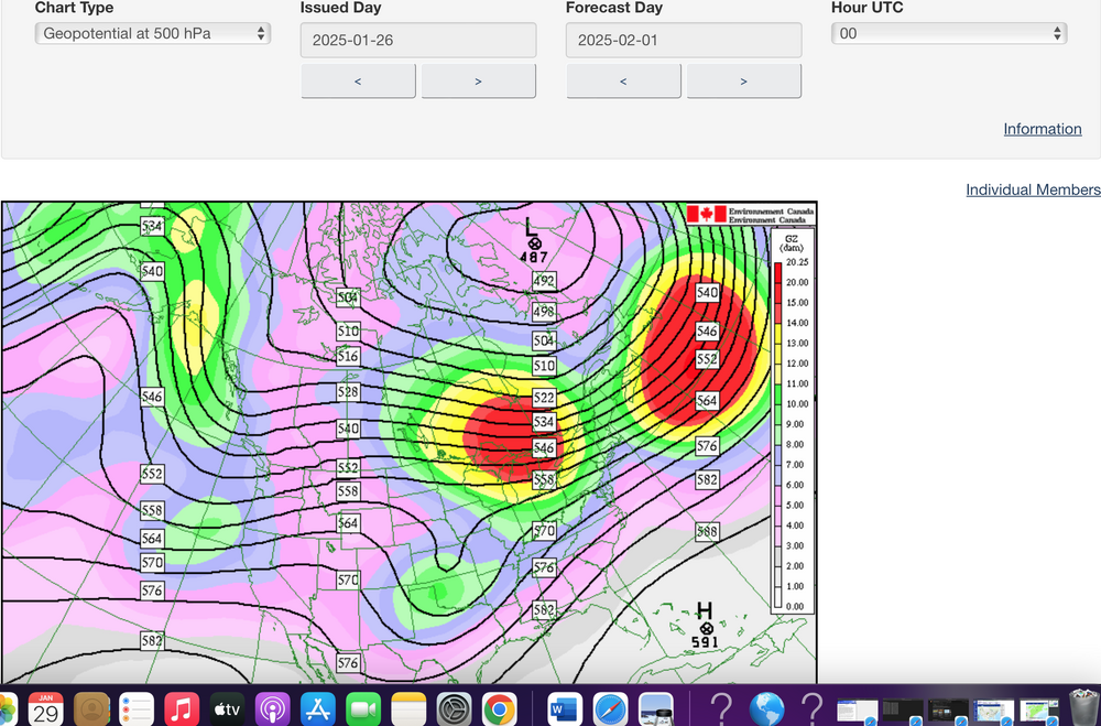
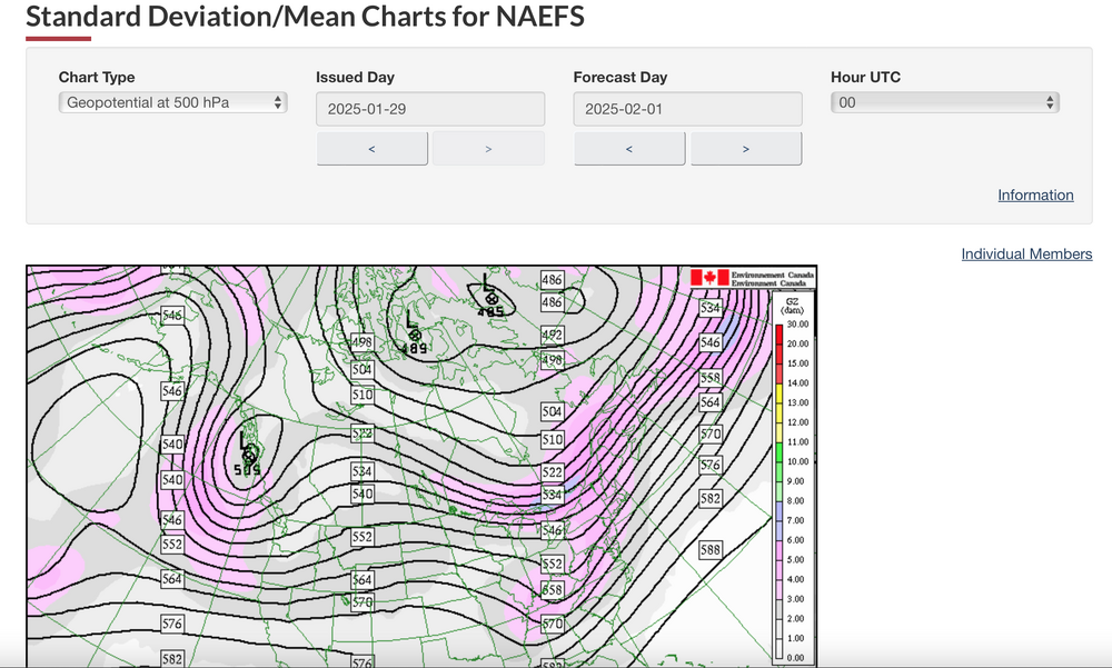
I will adjust the headline round 730-830A. Regarding the much faster approach of the originating CA short wave... I added two maps. The NAEFS ensemble used in the originating Sunday 26th post, where the short wave would be at 7PM Friday and the current prediction of where the short wave (opening 5H low) in this mornings modeling for 7P Fri. You probably see the speed change from the Central Plains to upper Ohio-Tn Valley---HUGE.
-
No headline change yet. Upper low now being modeled to lose its structure slower as it crosses PA Fri night. Next short wave seems to have neg tilt for Sunday evening. I guess I'm not convinced of the sfc low tracking north of us Fri-Fri night and 18z/28 EC op trying for some snow Sun night-Mon down to I80. I just want to make sure before I give it up in the headline, that its really no chance. Will rereview at 730A Wednesday.
-
wish it were believable... after we had a decent setup for this coming weekend, and even overnight still some GFS op's had snowy cycles.. but the same model ensembles said no and again the GEFS for 2/6-7 has less than an inch. I cant bite... still trying to salvage a part of this 2/1-2 weekend with some snow down here, which I still think is possible-but a long shot. (MODELS all over the place and rarely do I see a winter pattern miss by 24 hours on speed-all to do with the southern-northern stream interactions which I still dont think are resolved). In the meantime, maybe colder other nation ensembles will prevail but I dont like what I see in the GEFS. Maybe CPC will keep the door open more than what I see. Hang in there... it will snow again in NYC.
-
After 2/3, doesn't 5H look above normal to very large positive anomaly, and consequently less chance of snow than what little is on the table the next 6 days. I wont say this is it, but I enjoyed the cold and coming brief cold shots through this weekend. Wish it would have snowed more and maybe things will change, but to me it's looking like good timing via needle threading will be our best chance for a more than 4" snow into mid Feb for CP. Am I missing something?
-
Am aware of this thread looking to be a disaster... nothing for LI. I will adjust the headline late today after review of the daytime ensembles. The precip event has sped up by almost 24 hours from the initial estimate in the thread... and tracks too far north throughout the 3 day period. Still some uncertainty. Back a 6PM ish for a headline update.
-
Suggest no one settle on any one solution or even ensembles. There may be another two days of wobblings before we settle in. The Friday rain is about 12-18 sooner than I anticipated at thread starts yesterday. I still dont think the modeling has it right and so despite what I see, in any one model... I prefer to wait on writing anything off or in. At least its interesting... tremendous variability and mutidays of my wintry interest anyway. Glad to see a southward cycle... and hoping this continues a bit more. GEFS has two good short waves crossing PA Saturday and early Monday. LOTS of uncertainty. My comments on page two are in play.
-
uh oh... I laugh cause I dont know. IF the GFS 06z hadn't gotten back to what I think is on track, I'd have been more benign this morning but I just dont think north is a correct call. If you go to tropical tidbits ensembles at 5H and check the confluence zone on the latest cycles which is 06z EPS and GEFS and 00z CMCE, the confluence zone in my view is near the PA/NYS border or south of that. That indicates to me the ridge of high Pres is just north of that and the pcpn is south of the confluence. Also of interest is the next short wave crossing the upper midwest 06z/2... which induces WAA here later Sunday. Complicated and maybe the EF will be right and drive so much high pressure in here late first that nothing can happen. I'll leave it at that for all who say rain only. I do note 3 consecutive 24 hour periods of qpf on ALL ensembles here... ending 12z/1,2,3. Somewhere in there has to be an injection of colder air. My guess is by 12z Saturday with rain maybe Fri afternoon becoming mixed wintry during the night and ending as snow mid morning Sat, then refiring as snow/frzing drizzle Sunday. Complicated but I dont see this as one and done. Everyone knows my impression could be very wrong. At this point I wouldn't be briefing EM's etc that this is a rain only event south of I80 and LI. BOM continues snow acc LI by 00z/3 and that some of the OP modeling is trying for second qpf pulse here on the 2nd.
-
This may end up being a Friday night-Saturday morning event, followed by another late Sunday. No strong consensus yet. There will are model corrections but I think it unlikely this is north trending. First one probably starts as rain coast, mix inland high terrain... how it tapers Sat? The colder one later Sunday seems destined to be our LI snow producer. Plenty of time to adjust.
-
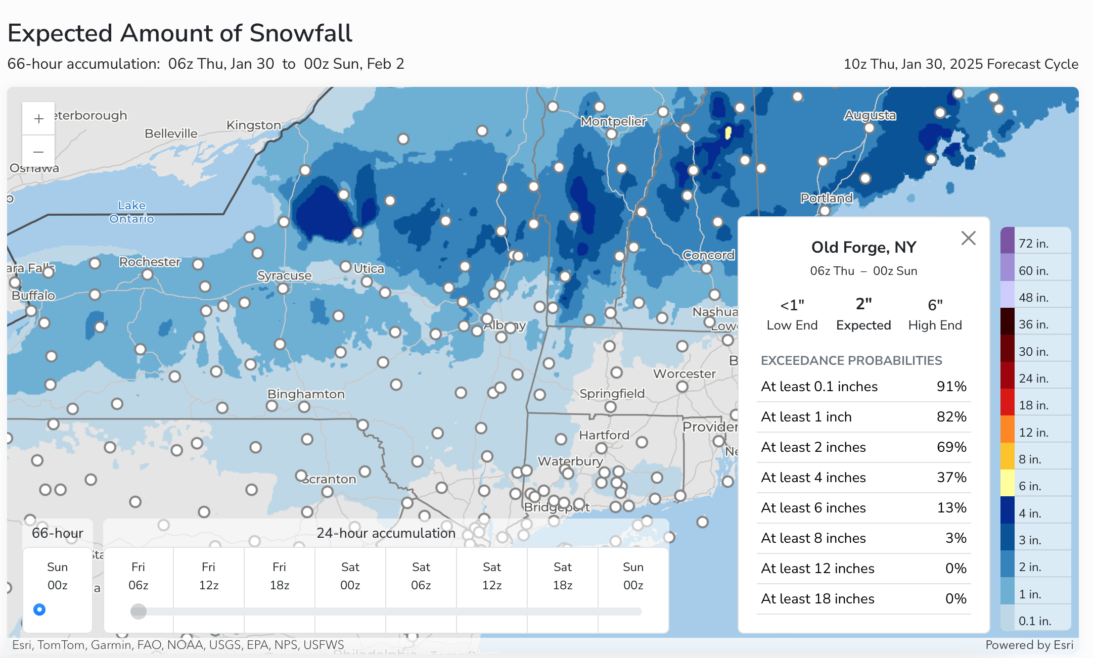
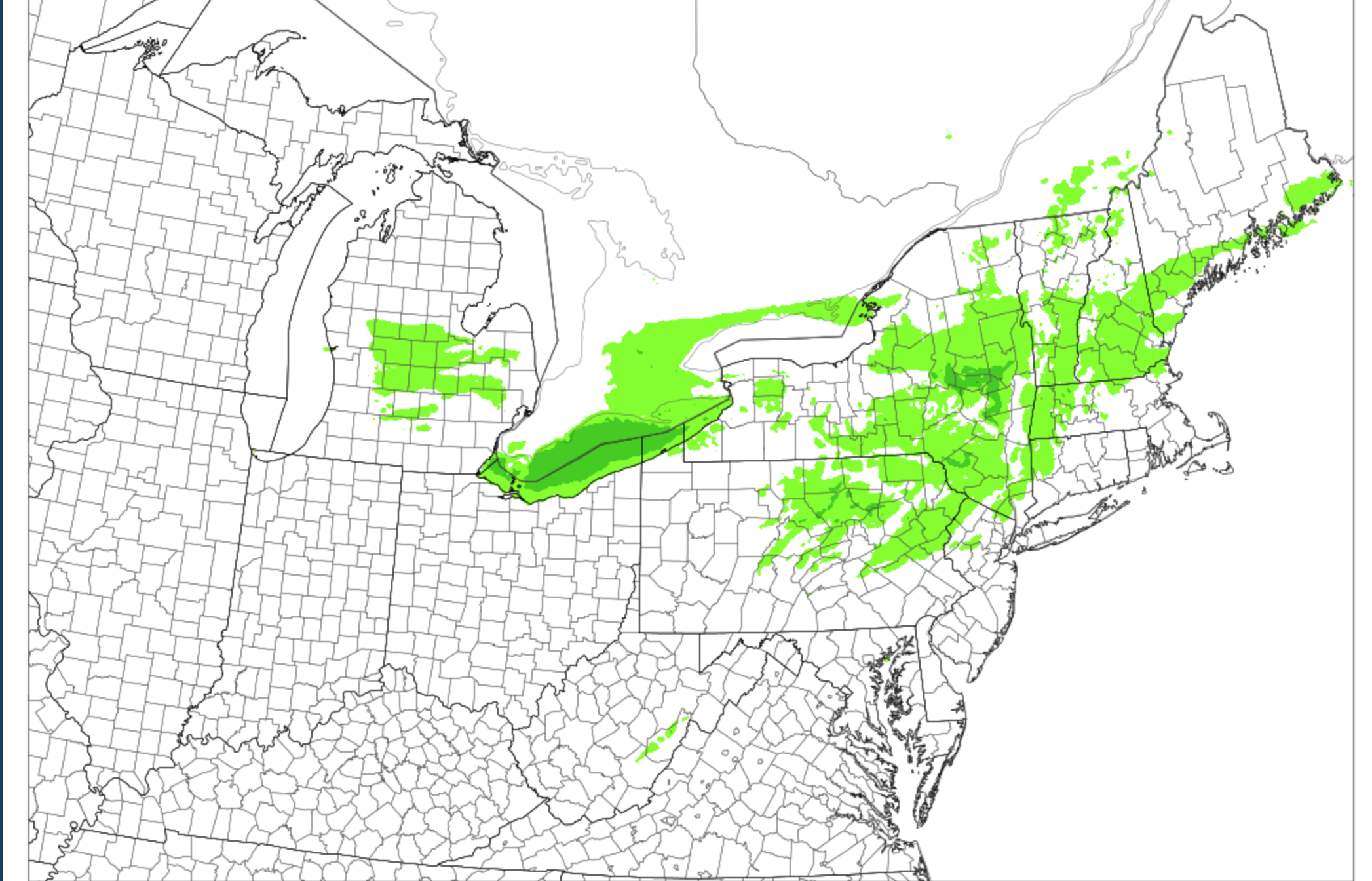
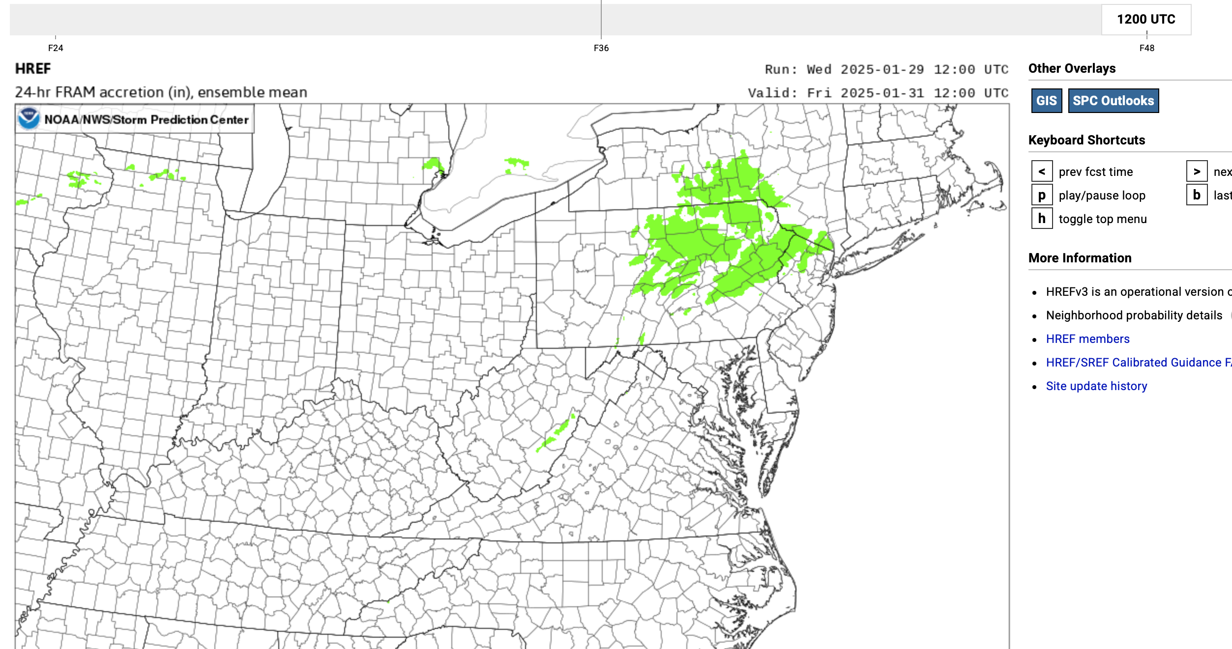
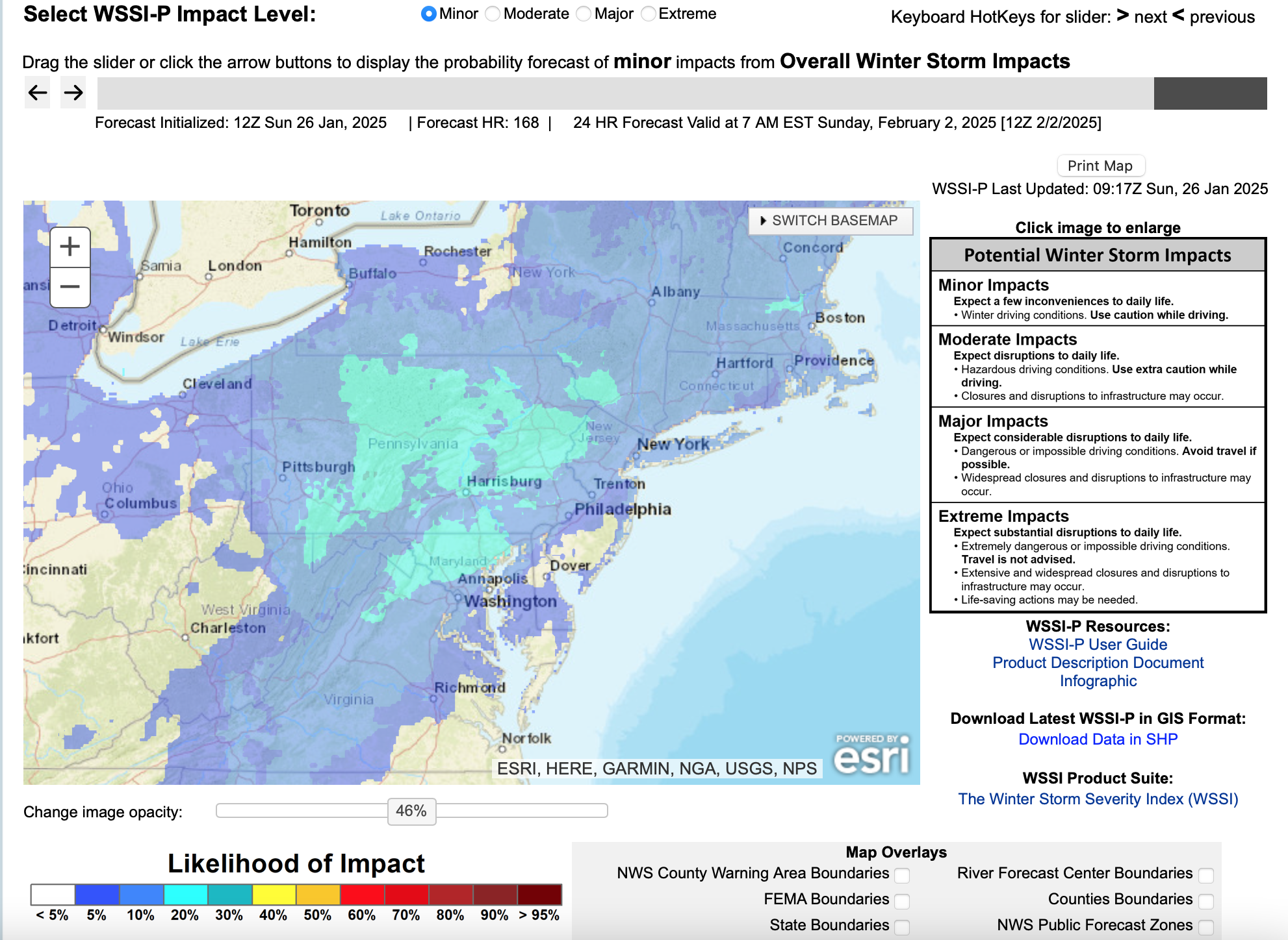
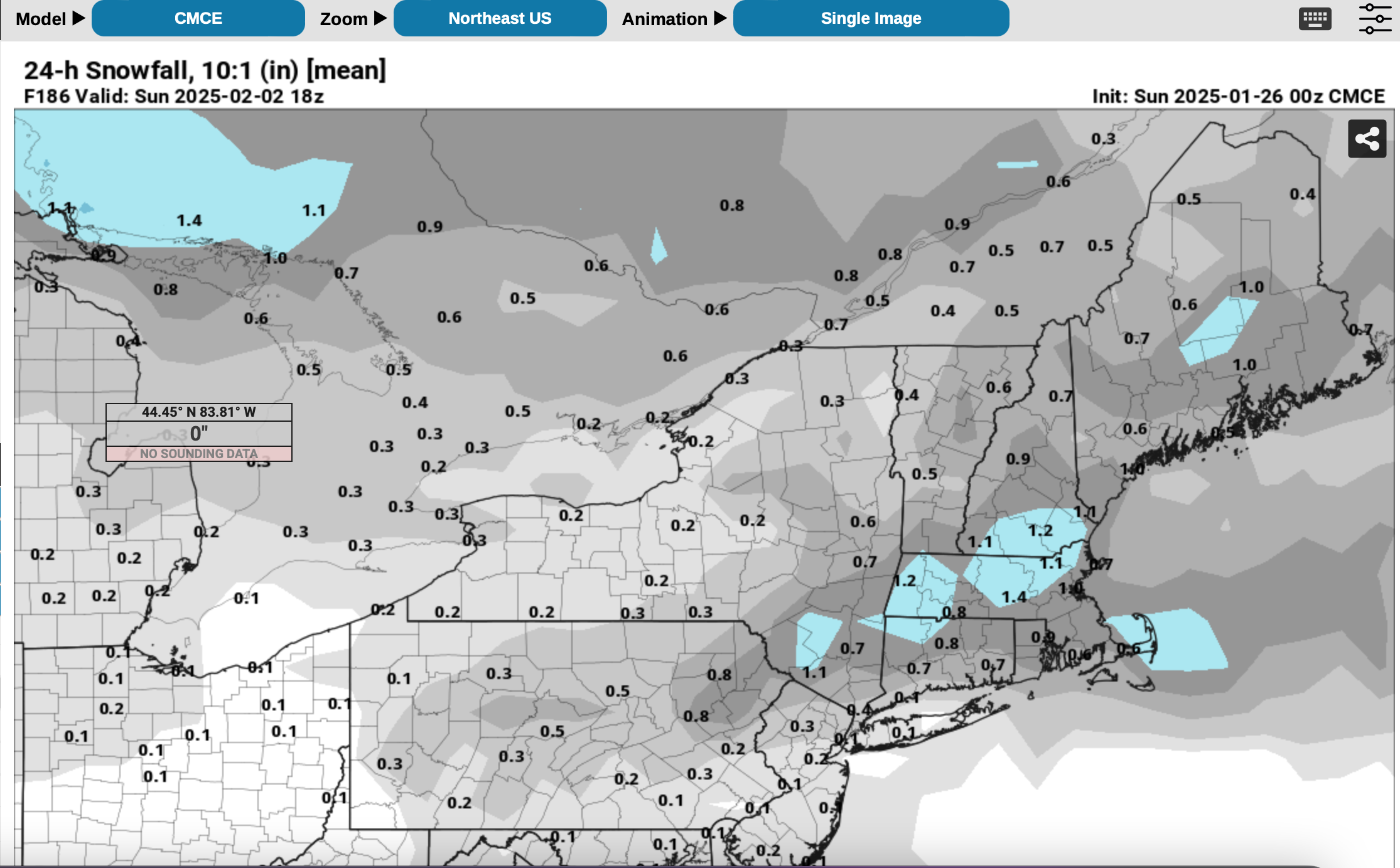
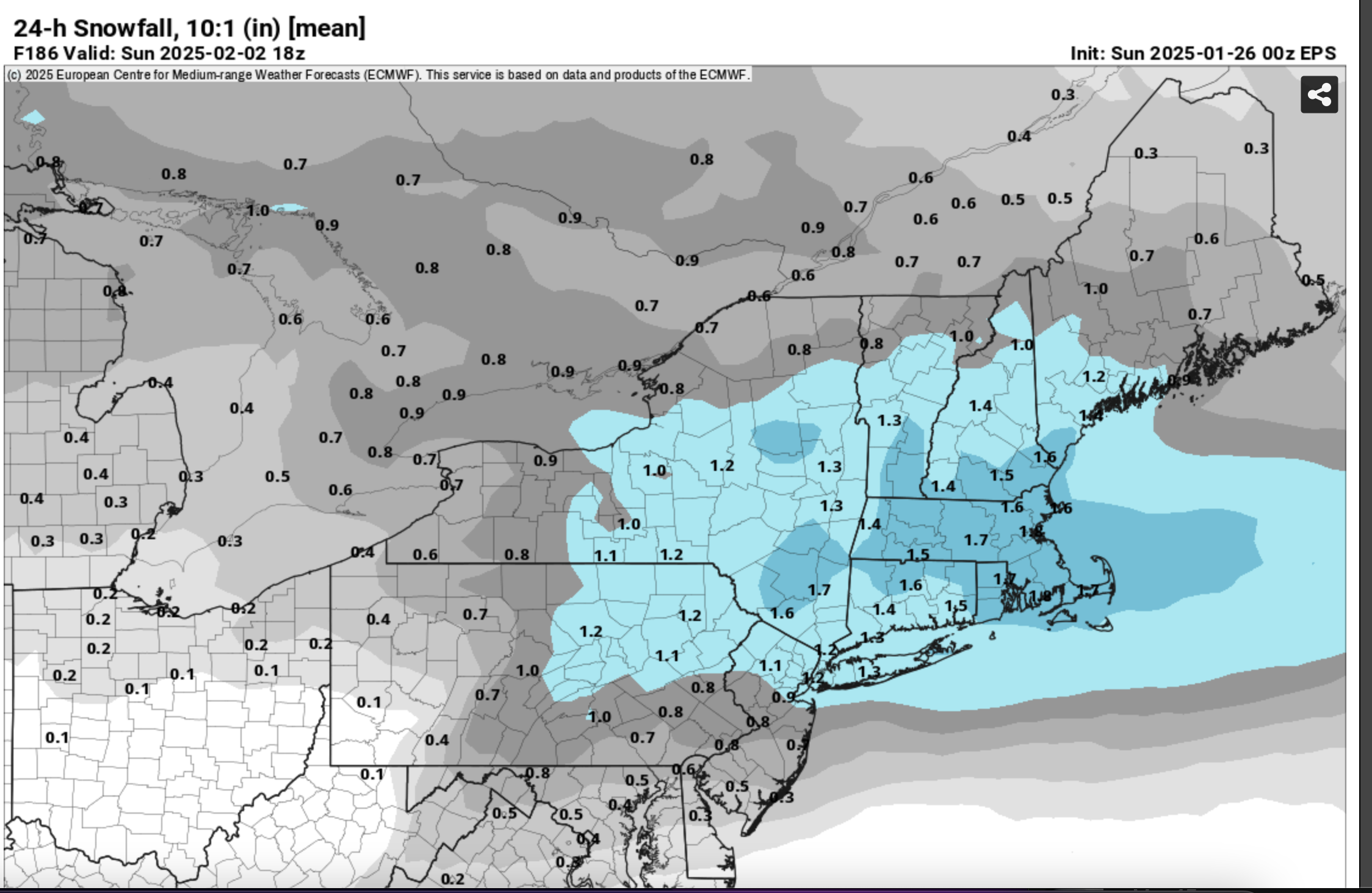
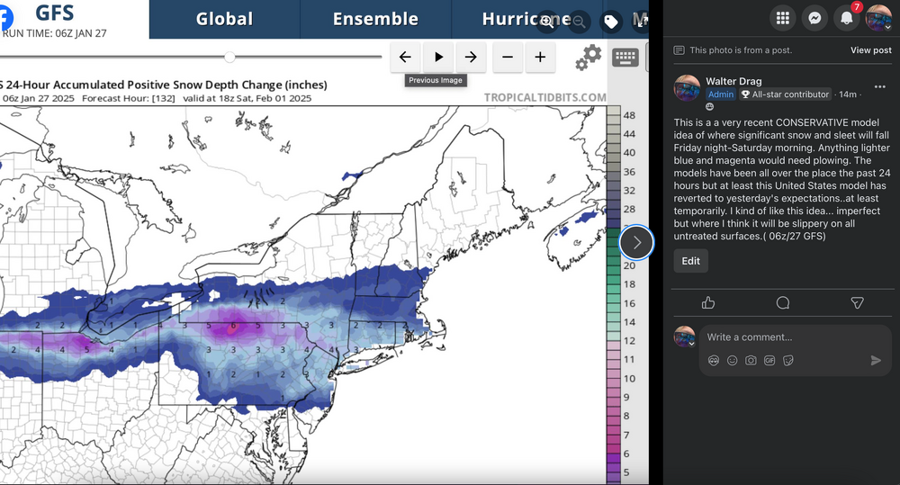
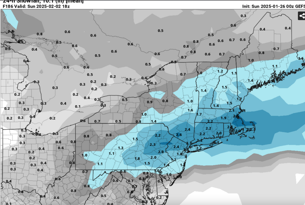
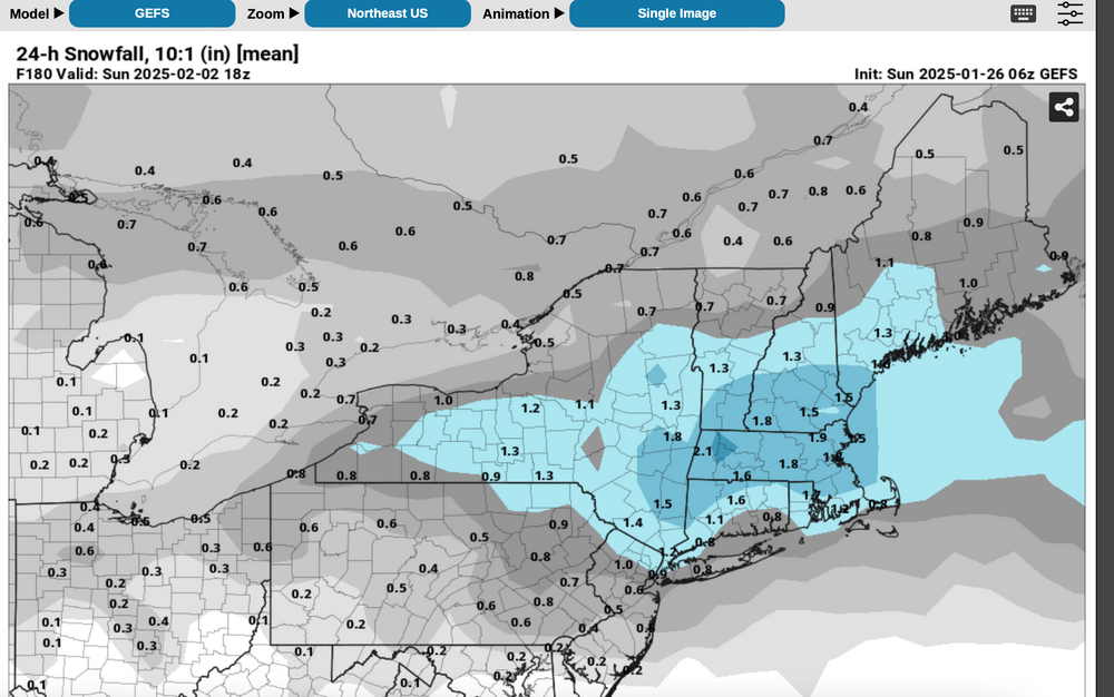
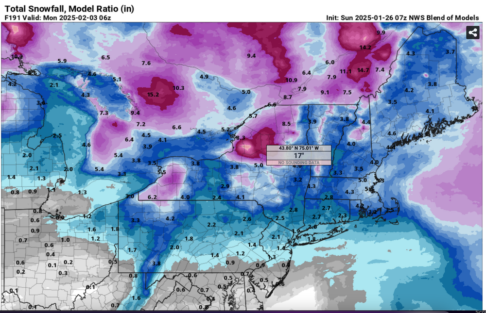
Good morning all, This what I'm using for planning. The 06z GFS rescued what I think is messy snow-ice event coming... I add these graphics and leave it all to you for debate. Model variability continues. Nothing locked. Feb 1-2: UNCERTAINTY and no cancellation action yet, but you may want to develop a plan B. Suggest planning for delays PANJ northward Friday night-Saturday morning as at least some snow and ice is expected. Timing and amounts uncertain. This may end up being a Friday night-Saturday morning event, followed by another late Sunday. No strong consensus yet but think it best to plan. First higher probability risk is near sunrise Saturday. Maps of small amounts of ice potential attached for Saturday as well as example of new snow fall that covers most of our membership from NYS-MA I90 south to the MD border. I added sidebar notes to the attached graphics.

-
Looks messy... long duration periodic winter event that seems to begin late Friday and ends in our area Monday morning. Aapparently most of the snow acc for Li the second half of the storm. Ice continues showing up inland..albeit minor (under 0.15 FRAM). So on the se ridge asserting and sending his north, you'll know for sure if the EC and AI don't trend south by Tuesdays' cycles. VERY early but I'm looking for an initial WAA burst Friday night-Saturday morning, maybe a break and then resurgence Sat night -Sunday with the modeled too rapidly dissipated 5H low transiting PA/NJ. Long ways to go and I be wrong in my interpretation, but for now a mess and LI probably less than 3" on the back side. I kind of like the tamers 18z GFS/GEFS vs the heavier 00z-12z cycles. (more reasonable qpf).
-
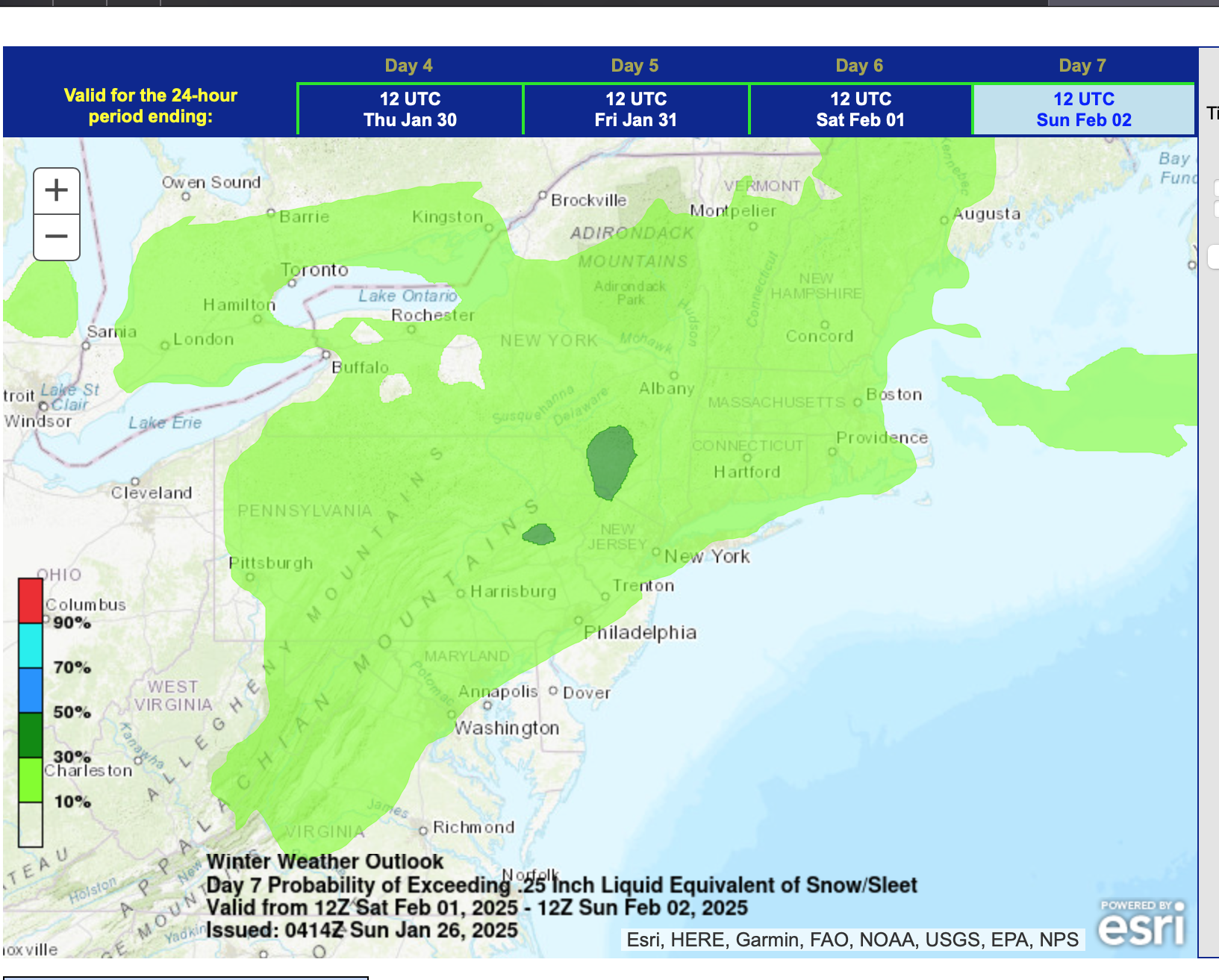
Good morning .. ECAI is always variable til it locks (I dont think its locked yet) and so it's part of the thought process that I needed to account for in the thread presentation. WPC already has a significant 30%+ prob of snow ice interior PA high terrain on D7. Both EPS-GEFS had decent 1"+ 10-1 snowfall ratio NYC area for D7, while the CMCE is almost non-existent. Thinking that the pattern is favorable for an event, some of it snow-ice. Would love all snow NYC but at this D7 post, not the likely solution based on all the info that I was able to review. In the meantime, don't be surprised at 0.1 snowfall Tuesday morning and again Wednesday morning NYC CP. Fingers crossed (mine anyway) that this is not a loser. I'm comfortable with this start. Failure is always an option but not likely in my opinion. Just how much of whatever precip type with qpf 0.5-1 inch range. It could be two periods embedded in this 00z/1-12z/3 time frame. What I wrote a small group this morning at 530A: Next weekend Feb 1-2: Monitor for delays and cancellations PANJ northward as at least some snow and ice is expected. Timing and amounts uncertain but this is looking significant. No action yet but maybe we'll know more tomorrow morning.
-
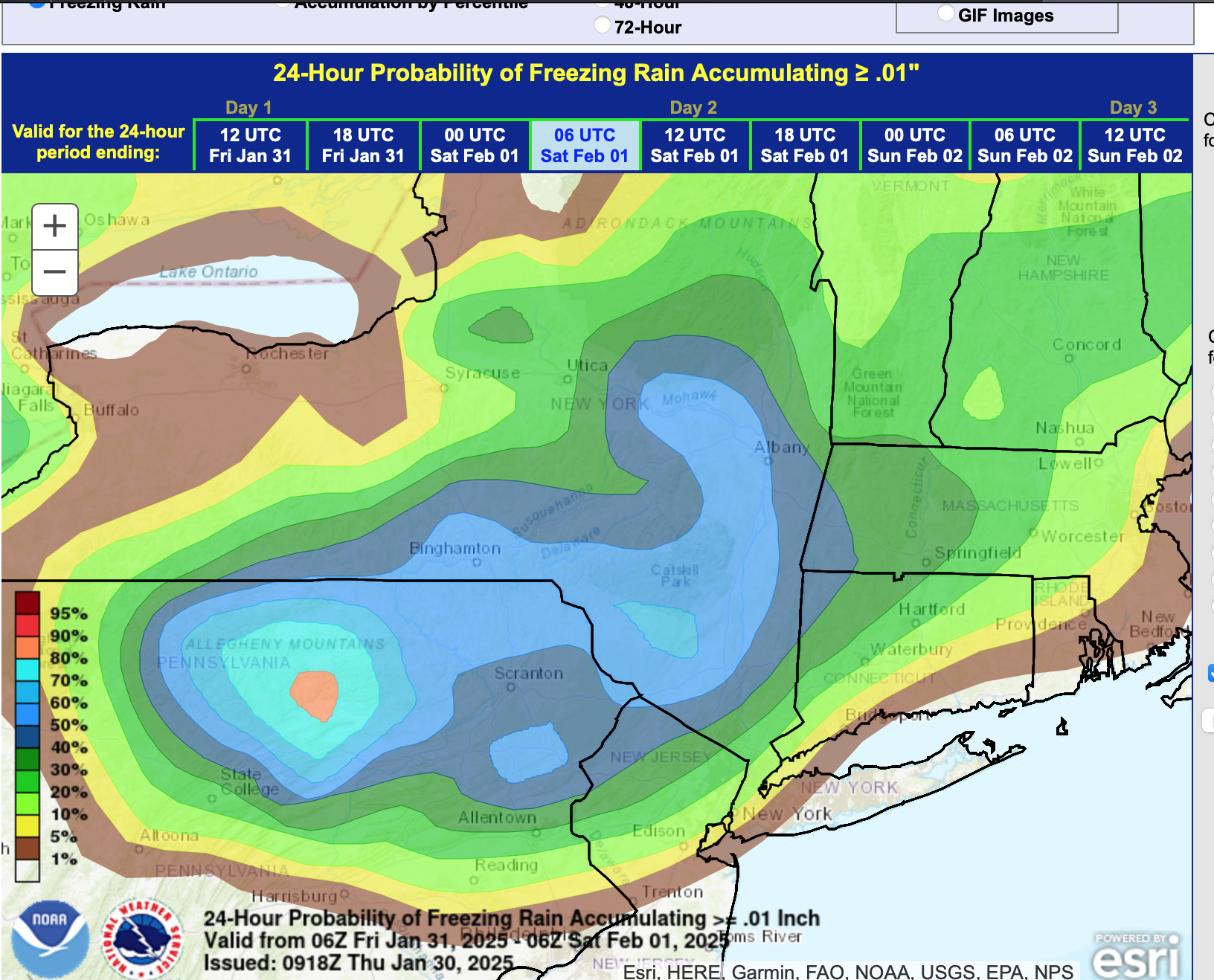
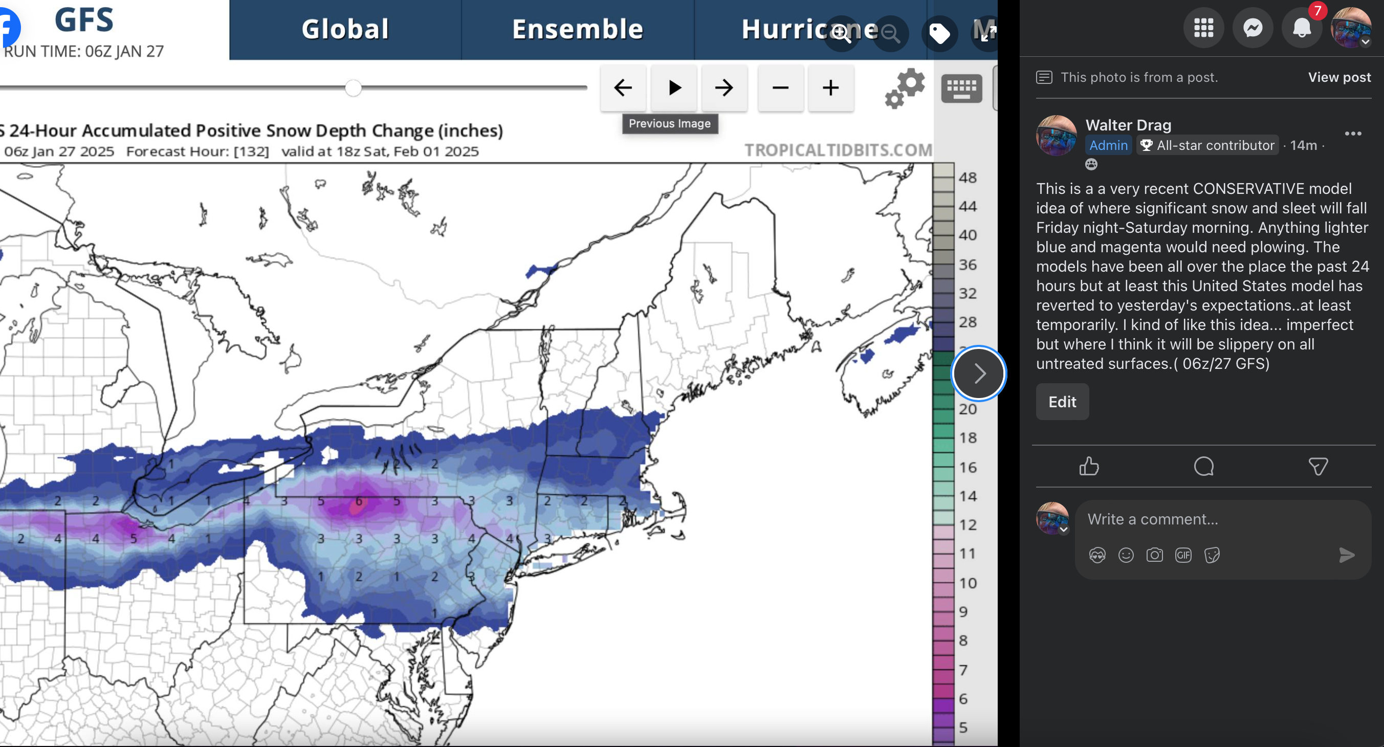
While most events are shaky on snowfall for LI due to thermal profiles, there should be a pool of subfreezing air covering the interior northeast during this event, available for making a messy winter storm, even down into NYC (NOT a KU). The remnants of this mornings CA 5H closed low will weaken as it heads eastward into the confluence zone over the mid and North Atlantic states this coming weekend. The cold boundary layer airmass that arrives Thursday the 30th after passage of an Alberta clipper off the Maine coast, should be available to interact with the Gulf moisture and lift generated moisture caused by the thickness overrunning ahead of the weakening upper low. Modeling is implying a secondary CFP Friday evening that will allow that BL cold in NYS-New England to be nearby. Precipitation type will be problematic due to the thermal profiles but the attached ensemble guidance suggests that this system is of trackable interest for our NYC subforum -both for travel into the interior where impact will be greater, and maybe witnessing some snow accumulation in NYC-though melting is anticipated on LI at times. Can our NYC 24-25 winter snowfall increase an inch or 2" next weekend (corrected my prior CP snowfall error). Ensembles should be self explanatory. I did add the EPS probability of >0.10 freezing rain Headline change below at 730AM Wed 1/29 for failed 7 day lead time on wintry accums NYC-LI. Discussion-OBS Jan 31-Feb 2 rain, potential minor interior impact mixed wintry events, mainly Fri Jan 31, Sun afternoon-eve Feb 2. Failed 7 day lead time LI winter impact. Events accelerated 18 hours and warmer-further north than modeling posted below in this thread indicated. Wrap up hat happened will post Monday Feb 3. P5 shows the NAEFS speed change. Self rated C-performance (see p 15 results against the ensembles posted here). Back end snow event entire subforum salvaged a terrible start. Max axis was significantly further north than ensembled. We had the Fri morning ice delays e PA/NJ/se NYS (24 hrs earlier than anticipated in this thread, but nothing else til the Sunday evening climatologically normal 1-3" snow event.


-
May begin a thread at 8A for 2/1-2 snow to rain LI and snow to ice interior suburbs...some accumulation all areas... for NYC probably just minor but so early in the analysis. More at 8A.
-
Nothing much for us in the snow - ice dept. I was too far south in my expectations yesterday. A few sprits of snow here and there through this Tue, minor less than 1/4" amounts. The Wednesday system looks mostly on or N of I84 with best chance 1-3" accumulation n of the Ma Pike. We do have wind chill factor tomorrow - Thursday. Feb looks opportunistic the first 10 days via some modeling, but no consensus on any of these being mostly snow events, not yet anyway. No new threads from me today. Have a good one.
-
try. Working Hands
-
I was too fast in Hospital ER 430A-930A (family flu) so the snow shower-squall event is reserved more for Tuesday morning. The Wed event right now looks too far north for much down here but I remain committed to monitoring the future of this event. n/c 2/1-2. No thread for me til tomorrow at the earliest, if then.
-
i84 corridor probably 2 orc3 wintry eventts before Feb3 with variable snowfall. Monday evening 1hr snow showers or a squall dusts some roads 1/4-1”. Sharp cold front with Great Lakes moisture yielding steep relatively moist lapse rates. Wednesday: some sort if snow acc entire corridor. The further north you go best chance 2-5”, probably CT portion but track important. If low goes south of LI it’s going to be nice. Too early for me to know. 2/1-2 at least some snow ice possibly change to rain but looks good for an event monitoring NtC for a Wednesday 1/29 thread but probably 10-30 hours too soon for me to be sure regarding a commitment
-
Will review at 5P for a possible Wed 29th thread.
-
Don, This is helpful. We can only hope to expand the sample size with larger snowfalls. BUT, all of us need to be aware that it might be too good for us the rest of the way in CP. Don's numbers suggest 5-10" more as the somewhat probable expectation, barring an unexpected significant snowfall in late January.
-
I hope for snow but a LaNina winter...bombing away Great Lakes (LES) and we had what I kind of thought was our most favorable situation in the winter... plenty of cold air. Saw CMCE but none of the modeling is showing consensus on a date and temps seems to be warming. I cross my fingers and hope for a big comeback in Feb-early March. It CAN happen. Just a little pessimistic since we've had a colder than normal DEC and much of JAN. I dont know what will happen but odds might not be in our favor? Don might have a lot more to say based on all his stats. Don- any comment these last 8 weeks of winter for CP?