wdrag
-
Posts
5,060 -
Joined
-
Last visited
Content Type
Profiles
Blogs
Forums
American Weather
Media Demo
Store
Gallery
Everything posted by wdrag
-
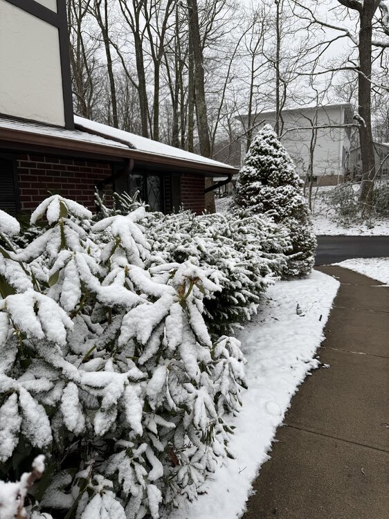
Wantage NJ at 740' elevation 1" at 4A with moderate snow, all surfaces covered. Going to be some power problems when high terrain above 1000 feet gets to 5 or 6" by 9AM. I added at 439A. Modeling suggests that snow on the grass wont completely melt til late Sunday afternoon in nw NJ...all elevations. Where 6" might not happen to melt til Monday afternoon.
-
No thread at this time but Thunder snow possible for NNJ as previous flash density shows. My guess is that parts of the 5 boroughs will see wet snow, sleet or small hail tomorrow morning. Trace at CP?
-
That is an option..., modeling differs. most favor double or triple the amounts in the Pocs-Catskills Sussex County NJ, whilst the 12z Canadian likes MA/RI. Development of the upper low to me favors e NYS/e PA... not in stone, except am pretty sure most of I84 wakes up to new snow on the ground and/or in progress with the band of snow in CT/MA seeming more progressive to the north with the banding hanging way back of the sfc low.
-
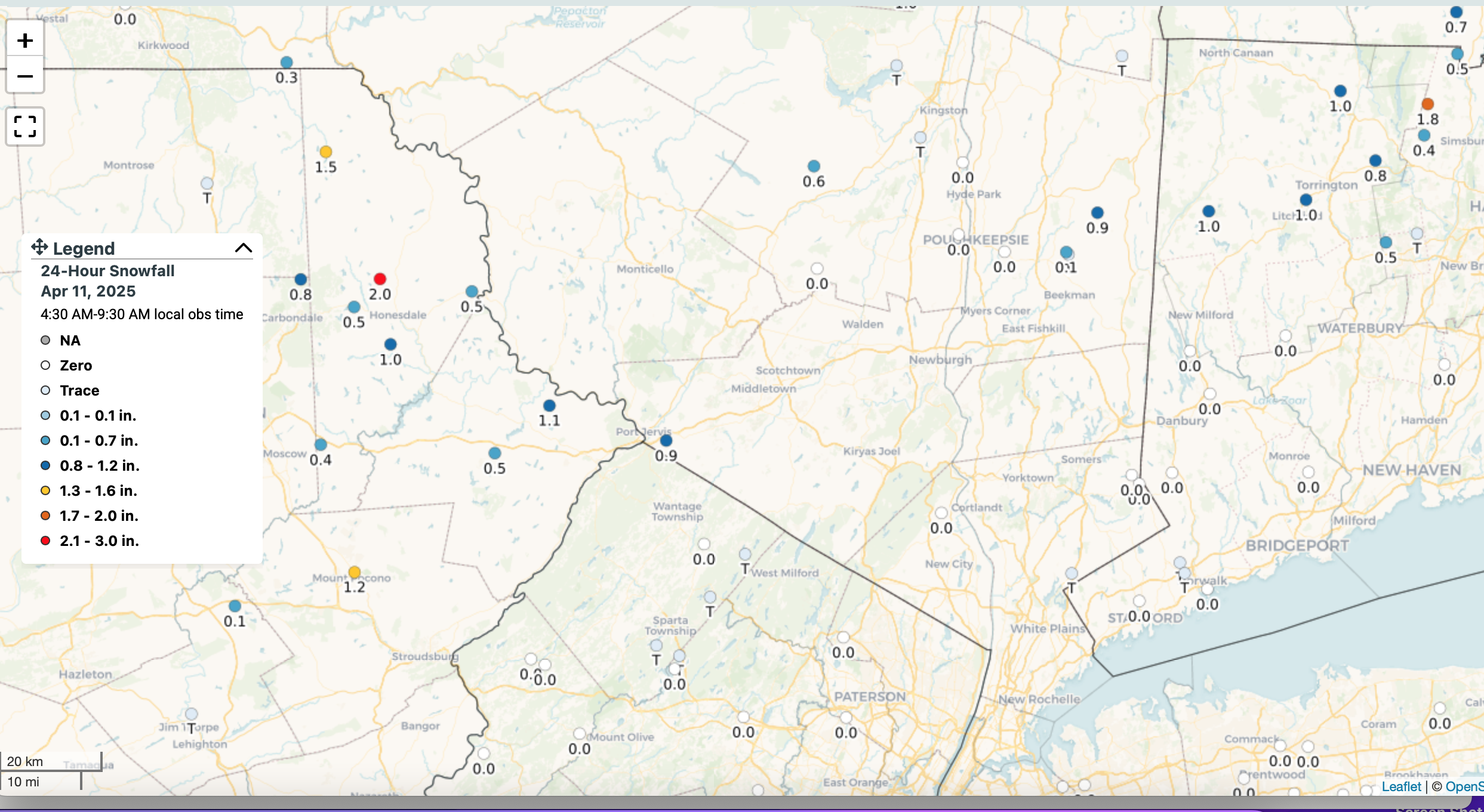
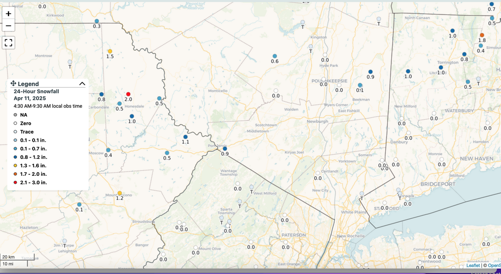
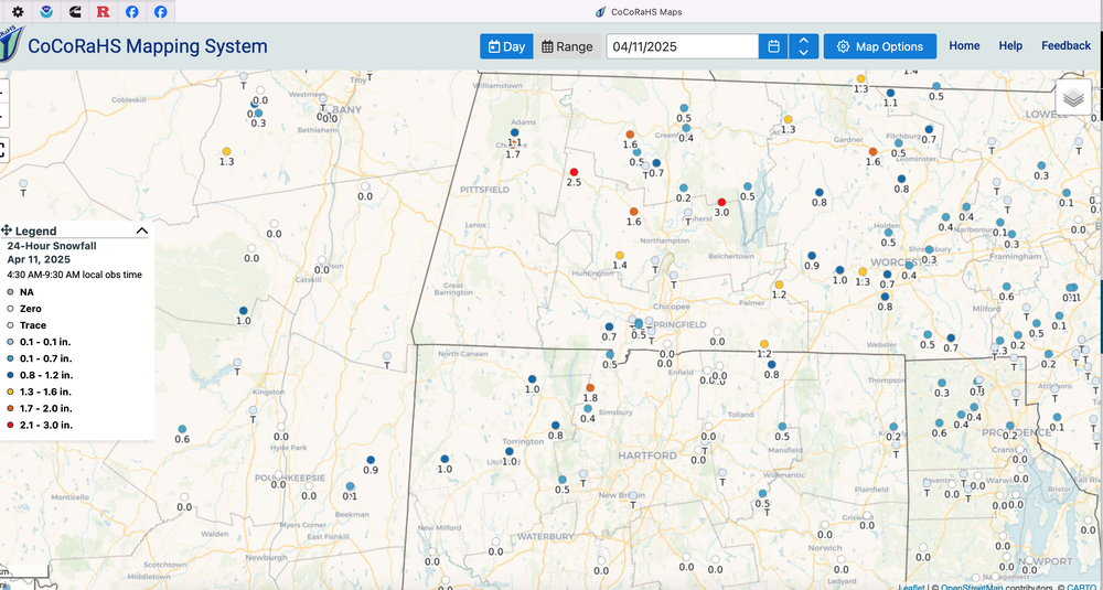
Looking like heavier wet snow tonight... isolated 3-5" se NYS-Poçonos-Litchfield County 2A-10A Sat. CoCoRaHs as of 9A this morning and a pic from about 2000' Mt Cobb area of PA exit 8 I84.
-
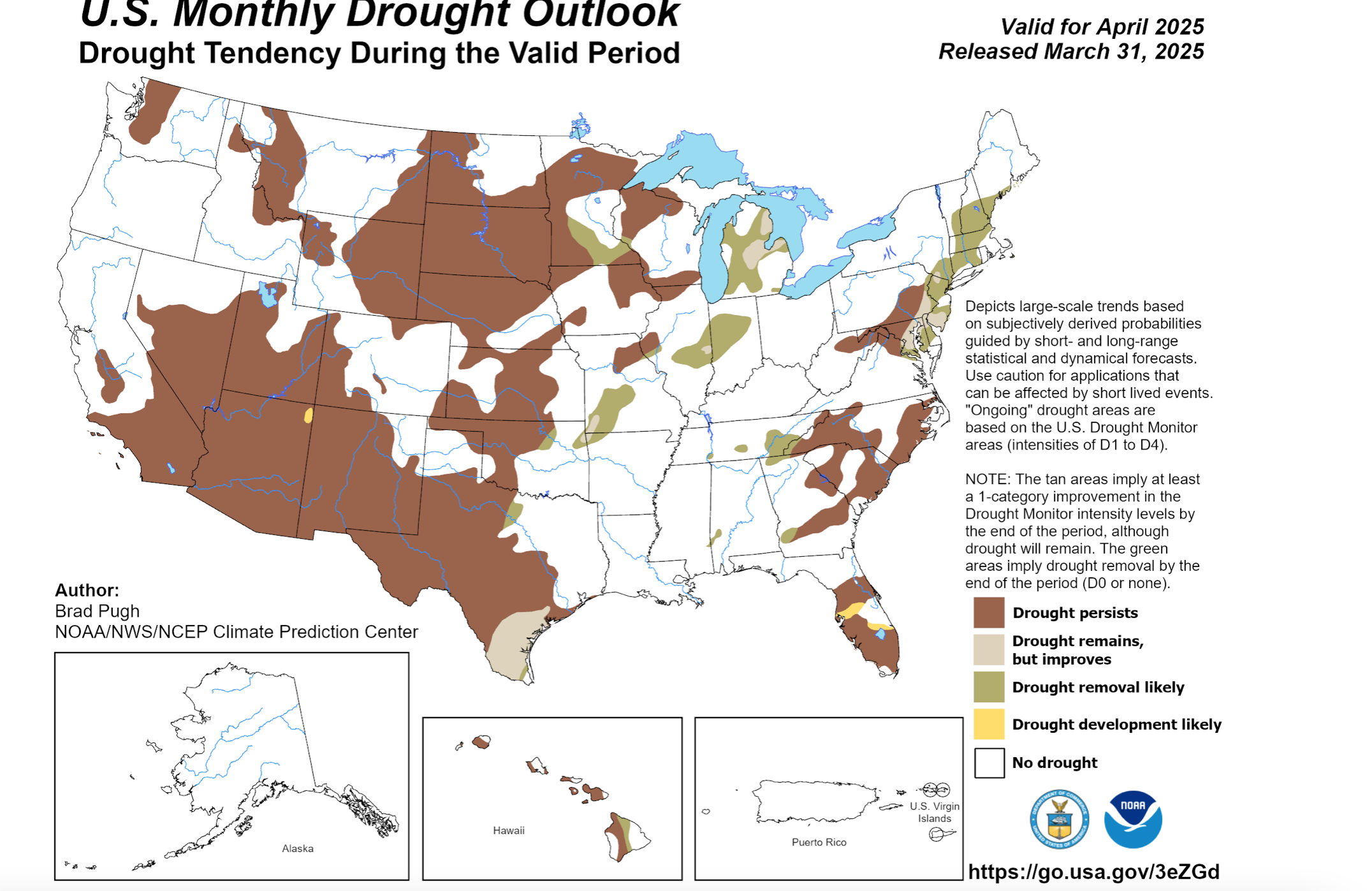
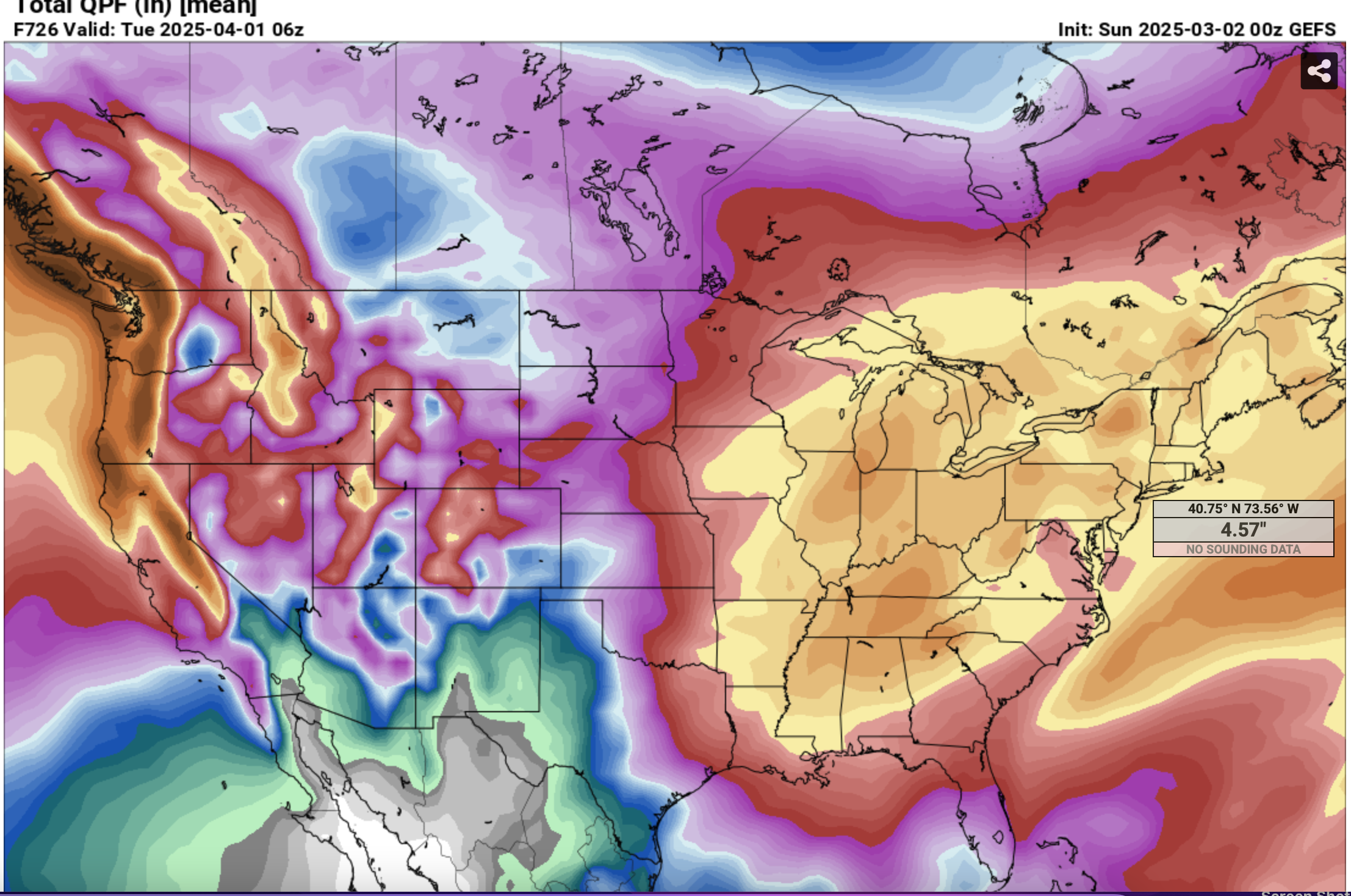
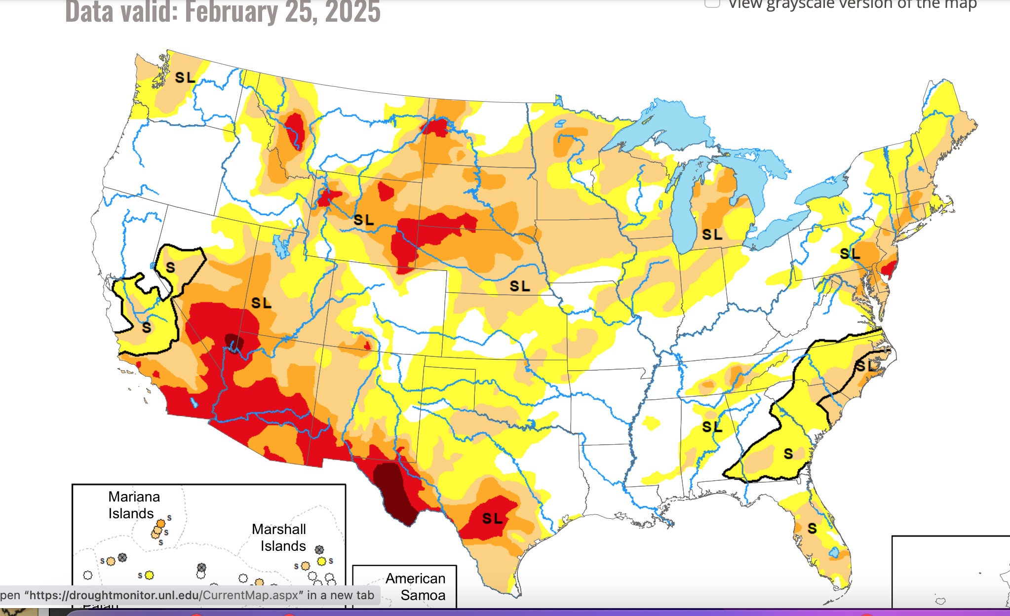
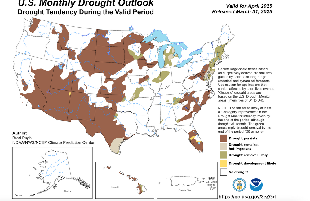
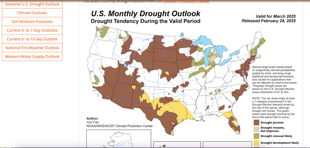
Attached drought monitor prediction 3/31. While we're on the se edge of bigger Nina rainfall Ohio River Valley next several weeks, we do get wet and its showing forecasted improvement. Not sure about a warmer than normal month... despite these first 4 days. Modeling trying to get us some wet snow I84 corridor this Mon/Tue and maybe next weekend. Something to monitor? Seems to me to ECAI is too heavy on snow but every cycle back to Wed has an inch or more elevations early this coming week. Warmer Canadian seems to be trending marginal colder precip as of the 12z/4 cycle.
-
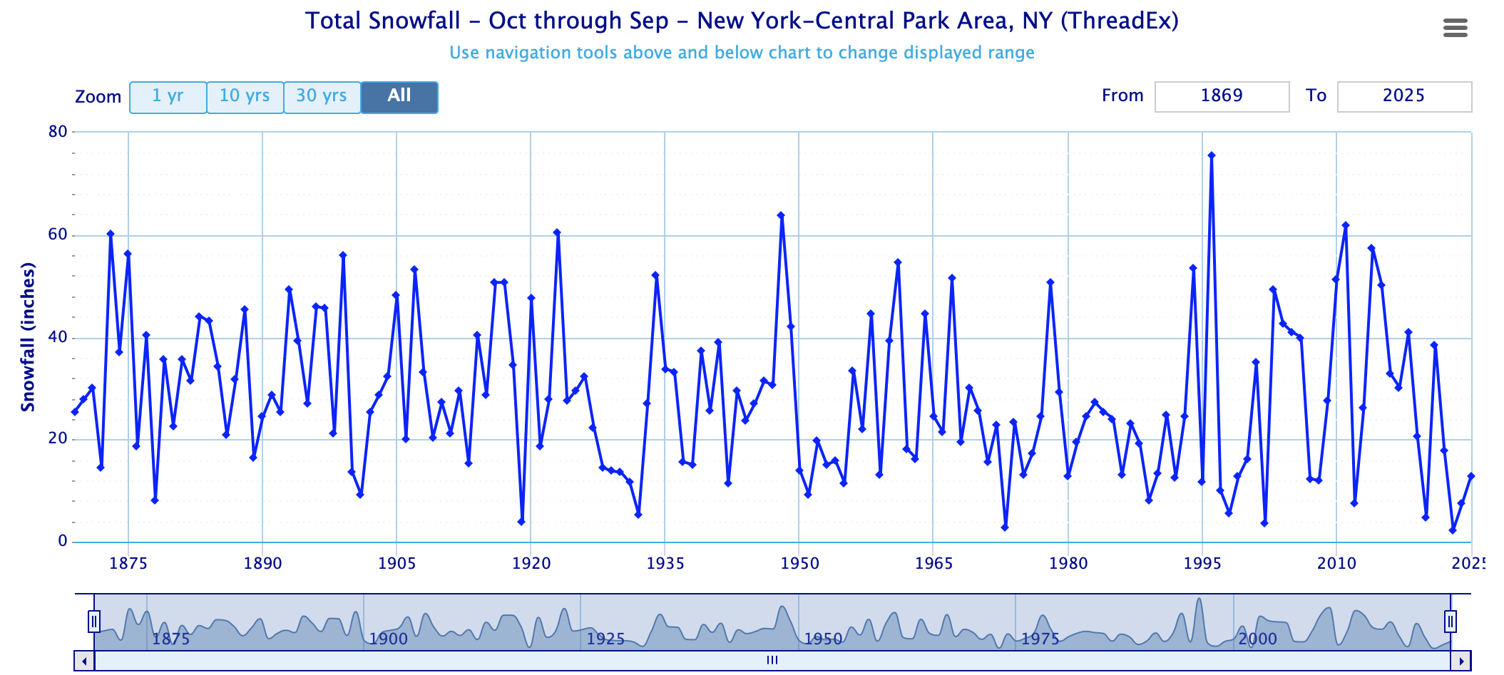
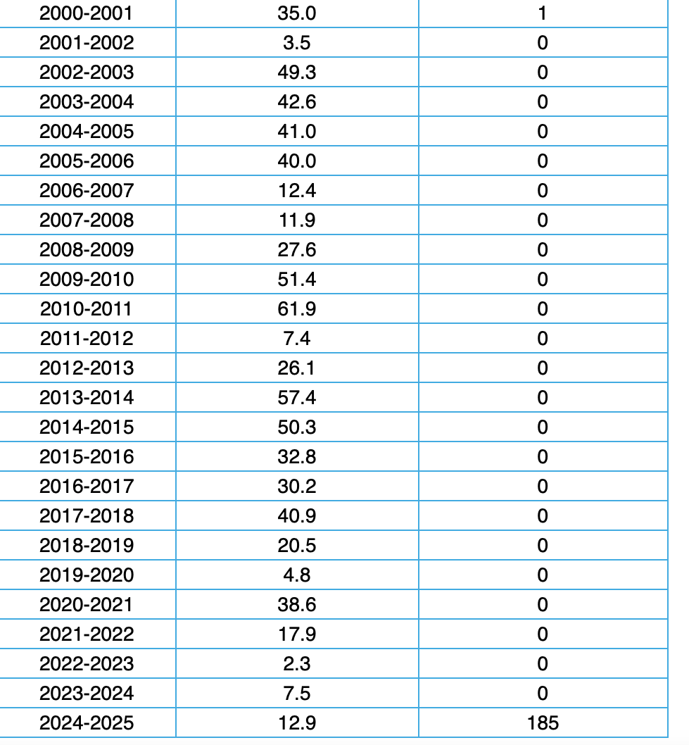
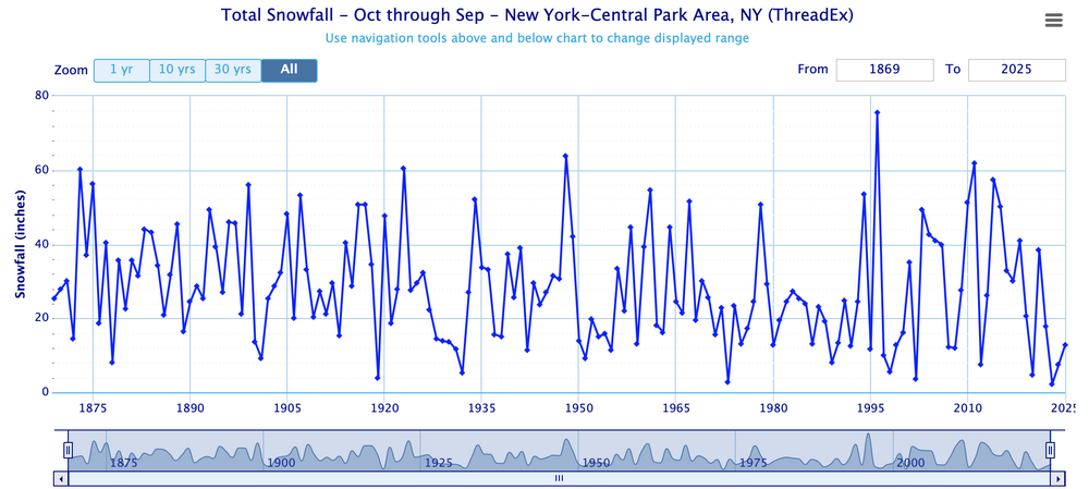
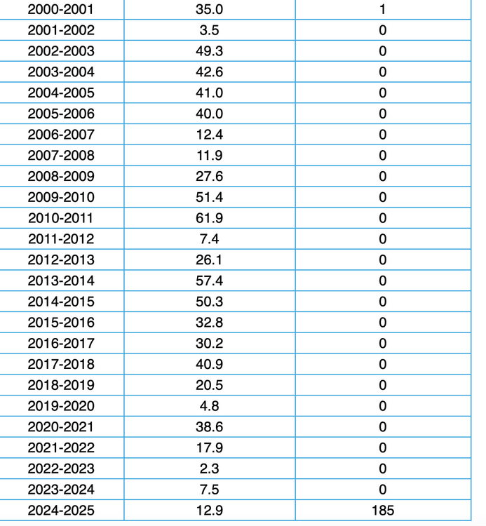
Now you can look back at your post last fall and know how you did at CP, as it's not likely we'll get much past the 12.9 for the winter so far at CP. Looks like this group of participant memories (age under 35) has gotten used to snowier winters and is/feels deprived. At least we did a little better than the past 2 winters. Still this winter seems to be averaging roughly 15" or more below normal seasonal snowfall.
-
Summary for the model too far south fail-lack of wintry yesterday morning: A few pings or sprits of snow-ice I84 corridor, mainly high terrain and especially northern MA but no NWS storm reports so basis of assessment is mPing and two day CoCoRaHs totals. A terrible March for us here in se NYS-nw NJ-Poconios regarding late winter snow. I still hold out hope but possibly winter is about done for me here - hasn't measured here at 740' elevation since Feb 20. The only reason I hold out hope is that sometimes a bang of a start to winter can end similarly with a branch breaker snowfall for the elevations. Modeling may again be biased too far south for the 4/2-4/25 snow-ice risk I84 corridor.
-
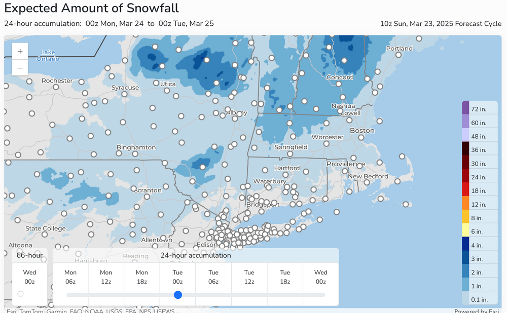
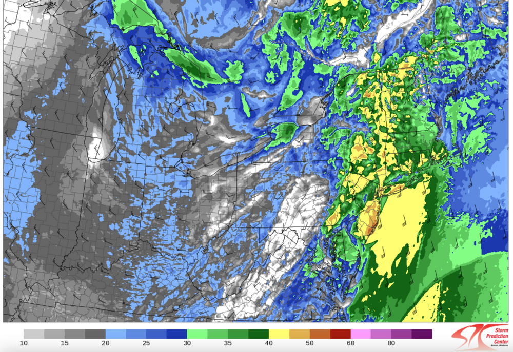
Good Sunday morning everyone, March 23. Just a quick post for not much of a Monday morning I84 high terrain problem. A bit of snow/sleet/ice tomorrow morning for our I84 members, mainly on I84 and north. This might cause a few slippery spots on untreated surfaces. Timing for the Poconos, and terrain above 1000 feet in nw NJ-se NYS-mainly 1A-8A Monday, and for far northern CT and interior MA mainly 4A-10A. Heaviest snow fall of 1-2" northwest MA, otherwise less than 1/2" elsewhere, if that. Just a nuisance but be alert near dawn. Rain quickly follows Monday morning-midday. The NWS 4AM snowfall map is attached. There ae no winter advisories posted for our members as of 6AM today. Noting the 11am modeling freezing rain signal seems to be increasing a bit for the Poconos-Catskills, extreme nw NJ high terrain above 1000 feet tomorrow morning. Nothing else widespread is ahead in this coolish next two weeks. Wednesday morning might be a target for the Poconos, nw NJ and se NYS but overall it doesn't look impressive.
-
Well... you could be right. My thinking is that there will be a mix of snow-sleet-freezing rain down to 1000 feet in ne PA/nw NJ with scattered slippery spots in the midnight-7AM Monday time frame (untreated). It can snow-sleet down to lowest elevations there but not accumulate due to temps above freezing. Best areas for accumulations and necessary road treatments looks to me to be hills above 1000 feet, especially Catskills and n of I84 in CT/MA. That's prelim. HRRR looks like it might be too cold Monday 12z, but its temps run warm so a bit of a surprise. RGEM/Canadian have been a little colder so far. ECAI has edged north slightly the past few cycles.I have not checked wet bulbs yet at 12z Monday. More tomorrow morning... grand dadding this weekend.
-
OK.
-
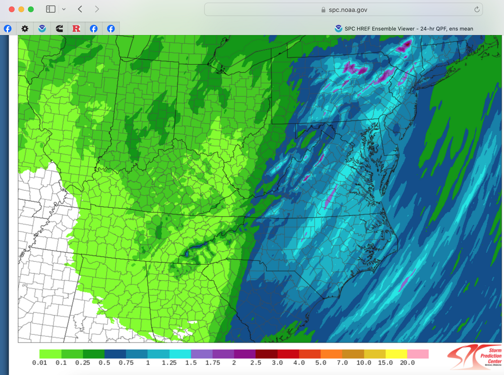
Traces of snow on the ground and/or in the air I84 high terrain, Poconos to w MA and CT overnight. Attached qpf verifies the Canadian and ECMWF modeling from 00z/20 with the GFS/GEFS continuing relatively poor verification against these global models. SPC HREF did not capture the event properly until 00z/21... 3-6 hours before occurrence. I continue to monitor-rely on EC AI versus other mode modeling for wintry vs rain. ECAI many consecutive cycles continues to announce a hazardous snow ice event I84 corridor, mainly North of I84 Monday morning...suggesting winter driving habits, slower travel and /or travel delays should be in mind for those having to move along I84 higher terrain Monday morning in a healthy event.
-
Good Thursday morning everyone I84 corridor, Welcome spring -March 20! Nothing big for our I84 corridor members which includes se NYS, w CT, ne PA north of I78 and nw NJ hills of Sussex, Warren, Passaic and Morris counties. A little wet snow will occur with the rains from time to time beginning early Friday morning (tomorrow) into the first week of April. Robins snow or maybe a touch more sometime next Monday, Wednesday mornings and next weekend. No details since no confidence on amounts but you will see a little bit of snow on the grass, at the least. Tomorrow morning might have a few icy spots near sunrise as rain ends as a little wet snow in the hills and temps fall below freezing. Probably no big deal. I'll update this Sunday morning regarding next weeks possible minor snow hazards for the I84 corridor. Again, welcome spring!
-
I've seen some posts about possible wet snow events around 3/21 AM and 3/24-25 etc. For now am not buying in... looks like a smidge of snow on the backside for I84, mainly elevations but that could change. My main reason for not jumping on it is the EC AI which has lost some faithfroma. few days ago... ie no closing off aloft and slowing soon enough for us..best for coastal NNE 3/21. The 3/24-25 event looks like the jet structure favors inland low pressure into N NYS... mainly too warm down here. Still could change but for now, am not enthusiastic about either.
-
Wind no thread. The 00z/16 SPC HREF MINIMUM wind gust forecast for 22z/16. This would suggest a wind advisory situation for at least coastal NJ to southern LI. This would also cover marginal svr cells that dont have clear cut severe markers and could go either way, especially their isolated damage nature. The lead time would be much larger. Not my call, but for me big wind is big wind, no matter clear air, shower or Tstorm related. 6z/16 NAM FOUS, my own rule of thumb precursor signals including BL wind exceeding 26KT. Hopefully no one finds a big tree branch on their car. SPC HREF indicators of isolated (spotty) 3" rainfall totals by tomorrow night in the NYC subforum, risk of primarily NJ/LI/CT. Graphic added. Brown is 45 MPH plus for 22z today. We'll see how it works out. It's the MIN gust model expectation.
-
I84 corridor: Aside from decent rain 3/4-2" and spotty 45-50 MPH wind gusts by 12z Monday (isolated power outages but not as extensive for us as 3/6-7), all consecutive cycles available on Pivotal of the ECAI are giving snow accumulation to the I84 corridor this coming Friday morning (3/21). Am monitoring for possible continued consistency. Would be nice to add on some sloppy wet snow to 25.6 here in this part of Wantage. Will check back next week.
-
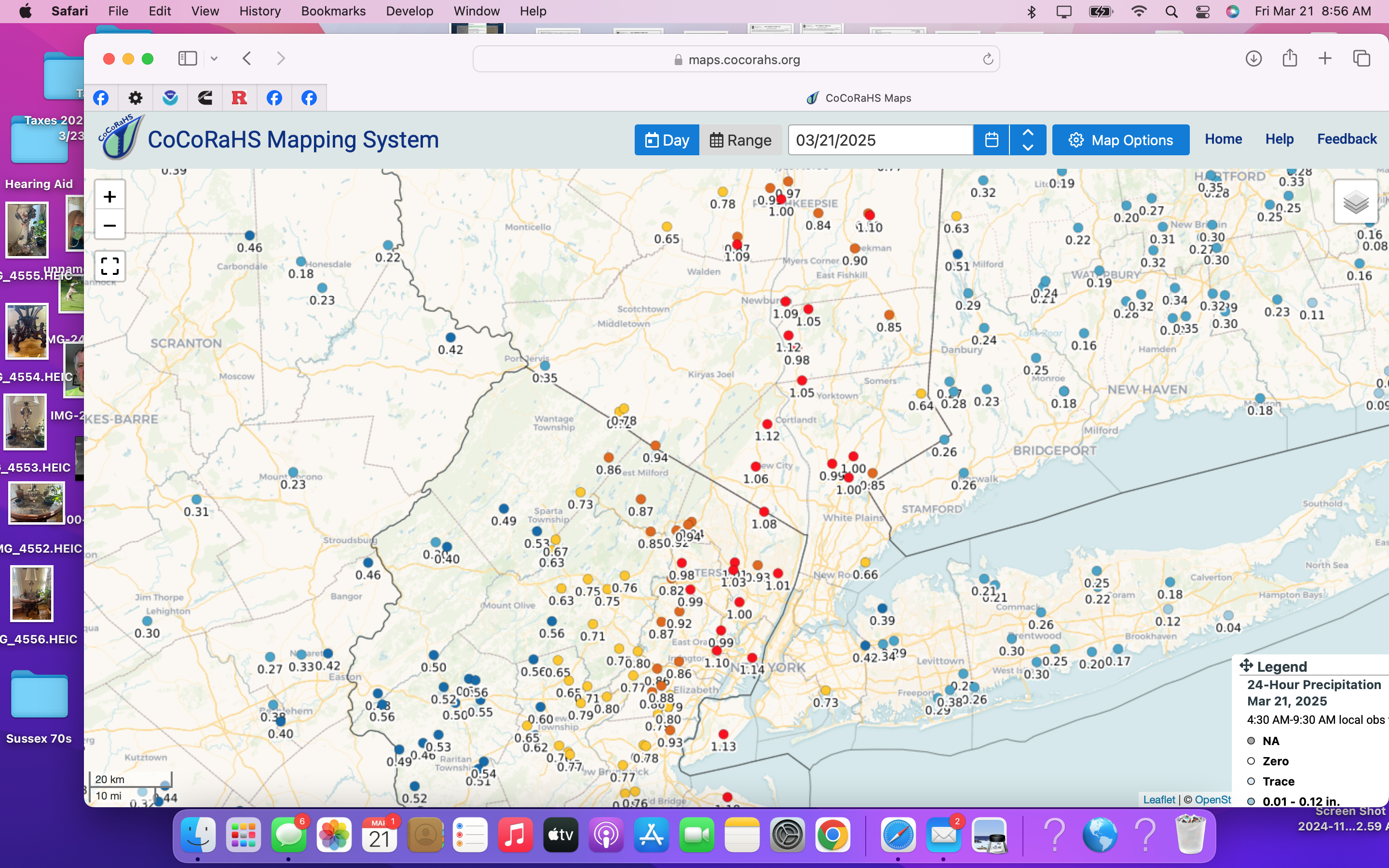
vsby 3/4SW- here in Wantage NJ. melting as it falls 31.5 down from earlier--916A Trace of whitening on grass/dirt but only a T and snowboards wet. 919A. sun out,
-
So this is the best we can do in what was once a long-long outlook (Feb 27 start) for a hazardous wintry snow event here this 3/6-10 period. Flurries now, maybe again tomorrow morning, maybe again Sunday night? Northern stream didnt deepen-dig quite as much modeled, probably because it left the southern stream energy behind so no phasing. Flurries are not a victory,but the chosen period was reasonable when outlooked earlier in the thread. More opportunities for 3/17 and beyond. First we may see heavy rain and high wind next weekend. No threads.
-
Yesterdays 12z/6 SPC HREF kind of missed the 1-2" swath along and e of I95. I dont think most of the modeling had NYC-LI close to what occurred.
-
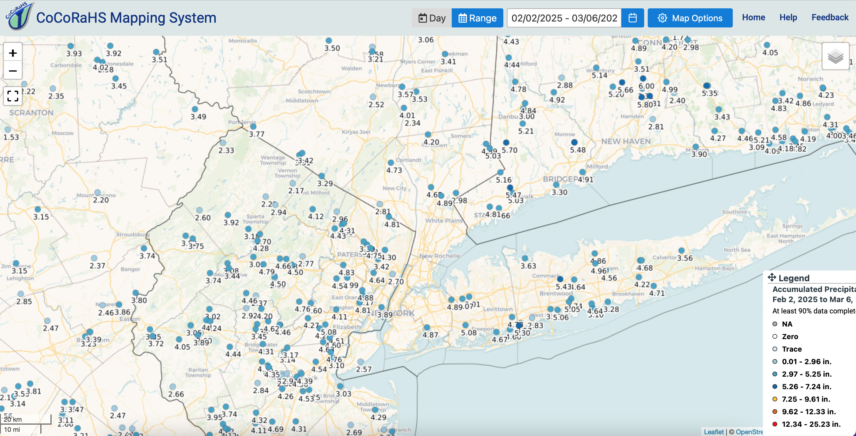
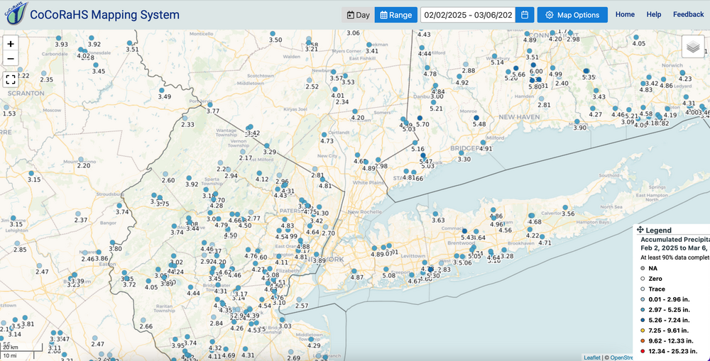
CoCoRaHs 2/2-3/6. Not too bad on GEFS prediction around 2/1. Not all correct but more so than not... Here tis. If interested click for clarity.
-
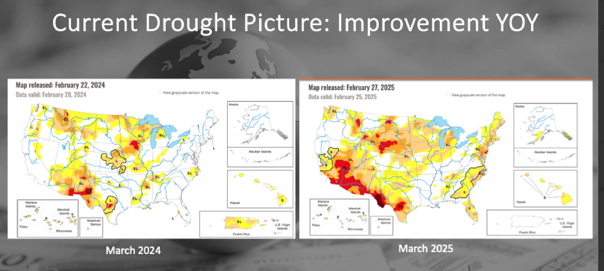
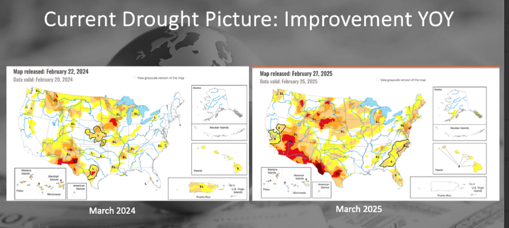
Wind advisory type events: IF, group wants an OBS thread for the isolated damaging gusts of 60MPH and somewhat more widespread 46MPH gusts I 80 south in PA/NJ, and across LI in the 3PM-midnight time frame, let me know. Otherwise just post here... we're getting 50+ now Delmarva. A repeat wind advisory episode should occur along and NORTH of I80- especially I84 corridor ridges midnight-Noon Friday morning including Poconos, much of CT, nw NJ, Southern NYS and probably marginally into LI. That one is the CAA backside segment. ALSO, Bob Harts wind extreme web site etc is discontinued due to Federal Funding issues. That means you have to go to other sources to keep up with max gusts. fwiw below: Comparison of drought monitor a year ago... borrowed from another link.
-
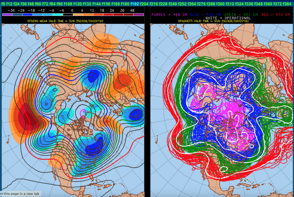
Two successive runs, 12z-18z/3, of enough members of the GEFS to phase and run us a nor'easter snowstorm the 9th. No other ensembling is close to the GEFS so, it could be - easy come easy go - if no phasing with the the southern Rockies remains of a closed low. The only thing I can say is that this fits days of ensembling that least some snow would occur I84 corridor with the GEFS tending to be most certain in the cyclic variations. Check back tomorrow to see if its gone or other modeling supports.
-
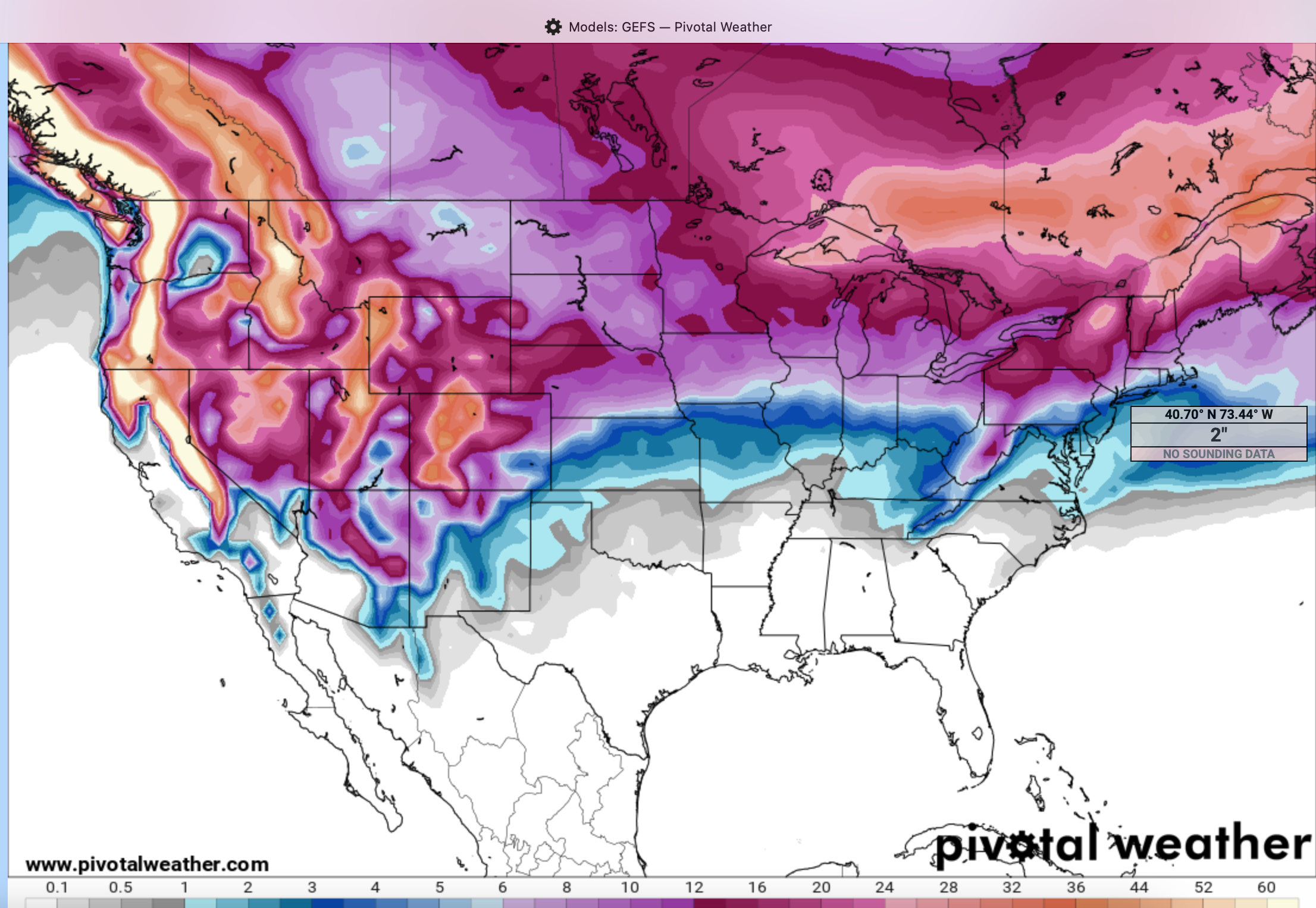
I look at GEFS monthlies out to 35 days... the data proposed on FEB 1 for our area through March 7 was pretty good... only short by half a foot on snowfall nw NJ-ne PA and near Asheville. Otherwise I thought helpful and the rainfall will work out to between 3-5" by the time Match 7 arrives.. already sitting at 2.25-3.5" the past month and the storm of 3/5 coming. That will have been good. That said... I add the GEFS through 4/1 as issued 00z/2. Take it for what its worth... keeping us steady in drought but not alarmingly short the next 4 weeks with some robins snow possibilities for NYC, and shovelable inches I84 corridor (yes I think we're all going to see a little snow here 3/6-3/10). So here goes. {+ snow depth change, 10-1 ratio snowfall, rainfall (yellow 4, browns 5+), modeled drought change which looks to me to be too conservative east slopes of the Rockies where drying and following summer heat may be a little more pronounced than currently outlooked and the drought monitor as of last week. For us in NYC... guidance might be a little high but I suspect close to 4" by the time March ends. It all starts 3/5. We can go back and check April 2... places along the east coast where I've drought concern is MD south. It's only a model ensemble, but I think we'll rainfall within an inch of modeled up here... and snowfall is more uncertain but for I84 its not a shutout.


-
Wantage NJ low 15.1 with wind and another slight dusting of snow on the ground by 5AM. Small possibly hazardous snow for the period 3/8-10 continues to look good, also now 3/14-16 period mixed. Small chance damaging wind potential Wed aft/eve convection, looks potentially somewhat more significant on NW flow across the ridges Thu night. Optics on WPC D7 qpf and chance 4" of snow (3z-05z/2) doesn't seem well coordinated. Problems for the public could start cropping up very soon on weather information dissemination from government sources.
-

-
Large differences between 00z/1 GEFS vs EPS-GEPS for 3/8-10. The latter two ensembles do not permit the southern system from coming north. From looking at the 5H 06z/1 ensemble members... it appears to me that a southern system will come north to affect our area with hazardous snow... that's my opinion only, probably more 3/9. I'll only back down when the GEFS shows WESTERLY flow here and confluence south of I80. All the 192hr 06z/1 green 5H members in the TN Valley is what I'm monitoring for change in the future. Alsmot looks like we're trying to separate streams. One day at a time.