

weathermedic
-
Posts
1,897 -
Joined
-
Last visited
Content Type
Profiles
Blogs
Forums
American Weather
Media Demo
Store
Gallery
Everything posted by weathermedic
-
Probably has to do with the elevation. Since the strongest winds are just above the surface, any increase in elevation makes it that much easier for the winds to reach those elevated surfaces.
-
At 9:55 AM EDT, Rock Tavern [Orange Co, NY] PUBLIC reports NON-TSTM WND GST of M67 MPH. GUST MEASURED FROM A HOME ANEMOMETER.
-
High wind watch just posted for the area for Monday. Winds can gust up to 70mph.
-
Suffolk County looks like it just exploded on radar.
-
Slight chance of severe weather later this afternoon/evening. Per NWS OKX: Attention then turns to the approaching cold front this afternoon into this evening and an associated line of showers and thunderstorms. High resolution models are in reasonable agreement with a broken line of showers and storms crossing the area between approximately 3pm and 8pm. Some of these storms could be strong to severe, with the best chances for any stronger storms across the Lower Hudson Valley, northeast New Jersey, and into southwest Connecticut, where warmer surface temperatures will help maximize instability. Damaging wind gusts are the greatest threat in any stronger storms that are able to develop, although an isolated tornado isn`t entirely out of the question. Showers and storms should decrease in intensity as they approach the coast this evening and encounter more stable marine air.
-
Heavy rain, some thunder and lightning and gusty winds here in Sheepshead Bay
-

February 2020 General Discussions & Observations Thread
weathermedic replied to Rtd208's topic in New York City Metro
37 degrees at 6 am. Was supposed to be 32-33 for overnight low. -
February 2020 General Discussions & Observations Thread
weathermedic replied to Rtd208's topic in New York City Metro
Wind gusted to 31 mph and temp up to 57 at noon at my station in Sheepshead Bay. Barometer 28.83. -
February 2020 General Discussions & Observations Thread
weathermedic replied to Rtd208's topic in New York City Metro
51 at my station in Sheepshead Bay with a southeast wind. -
February 2020 General Discussions & Observations Thread
weathermedic replied to Rtd208's topic in New York City Metro
Sun peeking out here at work just east of JFK airport. -
February 2020 General Discussions & Observations Thread
weathermedic replied to Rtd208's topic in New York City Metro
Lowest barometric pressure I can find is 28.88 at several locations in NJ. -
NYC/Nassau and as mentioned above all of coastal NJ upgraded to high wind warnings.
-
Upton just upgraded Suffolk County to a High Wind Warning. Also changed the wording in the Wind Advisory area for gusts up to 55 mph with isolated gusts up to 60 mph for NYC metro and coast.
-
February 2020 General Discussions & Observations Thread
weathermedic replied to Rtd208's topic in New York City Metro
Wind advisories up for basically the entire area tomorrow afternoon. From OKX late afternoon AFD: With the low rapidly deepening as it moves away, quick pressure rises with the onset of cold air advection will produce gusty conditions in the afternoon and evening with gusts continuing well into the night. The strongest gusts will be in the afternoon and early evening when modeled 850mb winds range mostly 45-65 kt. Will issue a wind advisory for all zones 18z-00z. Gusts up to around 50 mph are anticipated. Even some coastal areas may reach advisory criteria based on sustained winds of 30 mph. -
February 2020 General Discussions & Observations Thread
weathermedic replied to Rtd208's topic in New York City Metro
Some mangled flakes mixed with the rain here in southern Brooklyn as well. Temp 37 degrees. -
January 2020 General Discussions & Observations Thread
weathermedic replied to Rtd208's topic in New York City Metro
At the high for the day now at my station on a gusty nw wind...68 degrees. -
January 2020 General Discussions & Observations Thread
weathermedic replied to Rtd208's topic in New York City Metro
Made it up to 63 here before the clouds came in. -
Back edge of precipitation at nyc/long Island latitude already in western nj and moving quickly
-
January 2020 General Discussions & Observations Thread
weathermedic replied to Rtd208's topic in New York City Metro
Meanwhile....that band of snow over eastern PA looks pretty healthy and appears to be heading to NYC -
Nice article that explains why thunder sounds louder and travels further/lasts longer in colder temperatures: https://weather.com/science/weather-explainers/news/2019-02-21-cold-thunderstorms-winter-temperature-inversion-thunder
-
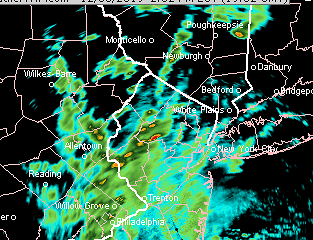
Can see the storms in NJ on radar
-
From OKX AFD: Fcst models show a developing axis of elevated instability with MUCAPE up to 500 J/kg moving across the NYC metro area and Long Island this afternoon, right on the back edge of the rain shield, and have added isolated thunder to the forecast for those areas.
-
Measured .75 total with both .25 with the first wave and .50 from the second. Wind gusted to 29 mph with the first wave and 25 with the second.
-
Streets now covered too.
-
Another nice burst of moderate snow here in southern Brooklyn Edit: make that heavy snow and gusty winds


