

weathermedic
-
Posts
1,897 -
Joined
-
Last visited
Content Type
Profiles
Blogs
Forums
American Weather
Media Demo
Store
Gallery
Everything posted by weathermedic
-
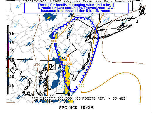
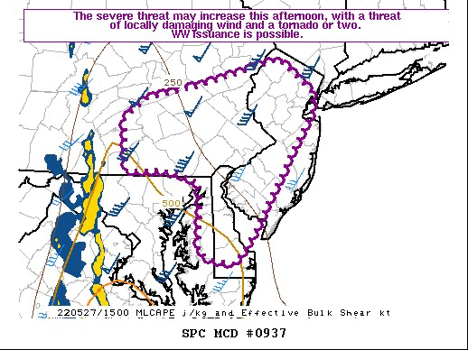
Mesoscale Discussion 1323 NWS Storm Prediction Center Norman OK 1216 PM CDT Sat Jul 02 2022 Areas affected...Parts of Northern VA...Eastern WV Panhandle...MD...DC...DE...NJ...Southeast PA Concerning...Severe potential...Severe Thunderstorm Watch likely Valid 021716Z - 021915Z Probability of Watch Issuance...80 percent SUMMARY...An increase in storm coverage and intensity is expected this afternoon, with an attendant risk of locally damaging wind gusts and isolated hail. Severe Thunderstorm Watch issuance is likely. DISCUSSION...Strong heating is underway across much of the Mid Atlantic early this afternoon, though cirrus emanating from convection over WV is limiting insolation across parts of northern VA. Convection is gradually increasing south of the cirrus shield across western VA, while cumulus is gradually increasing across southeast PA, to the north of the VA cirrus shield and south of another cirrus shield across central/eastern PA. Continued destabilization (MLCAPE increasing to near or above 2000 J/kg) will support scattered thunderstorm development later this afternoon, though local minima in storm coverage will be possible where persistent cirrus limits diurnal heating. This region is on the southern fringe of stronger midlevel flow associated with the deep mid/upper-level trough across eastern Canada. Effective shear of 30-40 kt across southeast PA into southern NJ will support the potential for a couple of organized clusters and/or marginal supercells, capable of locally damaging wind gusts and hail. Shear will be somewhat weaker into parts of MD/VA/DE, but still sufficient for a few multicell clusters capable of locally damaging wind gusts (especially where stronger heating occurs), and perhaps some isolated hail. Once a definitive uptick in storm coverage/intensity appears imminent, Severe Thunderstorm Watch issuance is likely across portions of the MCD area.
-
87/74 here.
-
Almost like a mini Chinook
-
Pretty impressive for mid June. Temp has been holding steady at 68 for the past few hours with mostly sunny skies here.
-
Hit 93 (down to 92 now) at my station with a west wind.
-
.89 here so far.
-
Looks like the main part of the BDCF is in central Suffolk County, but it is "bending" and just about to enter the north shore of eastern Nassau.
-
Seabreeze front has made it all the way to the north shore of Long Island. Back door front through central Suffolk county.
-
Down to 87 with the southerly wind shift at my station now.
-
Up to 96 now.
-
Davis site has an obs in Montauk at 70 degrees with an easterly wind.
-
94/66 H.I. 98 now at my station.
-
92/66 at my station on a NW wind helping to keep the humidity somewhat at bay.
-
TWC future radar has those showers/storms making it to the city around 1:30am
-
Watch expanding?
-
-
Well that escalated quickly. TORNADO WATCH OUTLINE UPDATE FOR WT 251 NWS STORM PREDICTION CENTER NORMAN OK 1135 AM EDT FRI MAY 20 2022 TORNADO WATCH 251 IS IN EFFECT UNTIL 700 PM EDT FOR THE FOLLOWING LOCATIONS NJC005-007-015-019-021-023-025-027-029-033-035-037-041-202300- /O.NEW.KWNS.TO.A.0251.220520T1535Z-220520T2300Z/ NJ . NEW JERSEY COUNTIES INCLUDED ARE BURLINGTON CAMDEN GLOUCESTER HUNTERDON MERCER MIDDLESEX MONMOUTH MORRIS OCEAN SALEM SOMERSET SUSSEX WARREN
-
Severe t-storm warnings with the MCS in south central PA. Still looks quite healthy on the radar.
-
Heat Advisories for areas north and west of NYC. Also seems as if the thunderstorm potential increased slightly: As the ridging attempts to get established and mid level shortwave will begin to approach and work through from the CWA. This MCC, or what`s left of it is now progged by most near term guidance to slide through late in the day and into this evening. There is uncertainty as to how much this MCC / MCV can maintain itself as it works east of the Appalachians and closer to the Atlantic seaboard. The instability and convection should become more elevated as it works east as it encounter the more stable air and relatively lower dewpoint / virtual temperature near surface profile. Look for a thunderstorm / thundershower chance from west to east as this system pushes through. This will ride basically north of a warm front down to the south. The remnant MCC /MCV should then eject to the ENE towards midnight. Thereafter the warm front approaches and pushes through towards daybreak Saturday morning. Look for a good deal of clouds and low level moisture to persist through much of the night until the warm front can clear the area. Lows will be above normal with cloud cover in place, along with patchy fog in spots, especially where rain can occur and moisten the ground
-
Storm in northern Queens just got severe warned.
-
They postponed the Mets game for this
-
The entire line up and down in NYS from the Canadian border to the PA/NJ border is severe warned.
-
Nice slug of rain on radar east of NJ/south of LI heading north. Should be a few hours worth of rain later this afternoon into the evening if it holds together.
-
Temp 58, RH down to 16% with a DP of 12 at my station. Pretty dry considering it being at night and on a stiff NE wind.
-
Not often RH stays in the 25 percent range with a persistent NE wind. Temp up to 61 from a morning low of 47 at my station. Strong May sun doing its work. Imagine how warm we would be if the wind was NW-W.


