CNY_WX
-
Posts
2,717 -
Joined
-
Last visited
Content Type
Profiles
Blogs
Forums
American Weather
Media Demo
Store
Gallery
Everything posted by CNY_WX
-

Major Winter Storm 2/6-2/7 OBS
CNY_WX replied to PaulyFromPlattsburgh's topic in Upstate New York/Pennsylvania
Divide amounts by 3. No way I’m getting 20 inches. -
Major Winter Storm 2/6-2/7 OBS
CNY_WX replied to PaulyFromPlattsburgh's topic in Upstate New York/Pennsylvania
KBGM is still calling for heavy snow tomorrow: Things turn for the worse tonight onward as a strong and further deepening low pressure moves up the Appalachians, and then right across our region Friday morning. This will be in concert with a strong upper wave and very good double-jet support (right entrance region of one, left exit of the other) providing forced ascent. Frontogenesis axis at the mid levels appears to set up right over the Finger Lakes through NY Thruway, with dynamic cooling changing rain to heavy snow late tonight-early Friday. The axis may pivot into the Twin Tiers for a time early-to-mid Friday before precipitation begins to take on a more showery nature, and lake-enhanced for that matter southeast of Lake Ontario late Friday into Friday night. Within the frontogenetical band, 1-2 inch per hour snowfall rates appear achievable. Though the Winter Storm Watch counties - much of Central NY - is where confidence is higher for heavy snowfall totals, it should be noted that even to the south in the Twin Tiers, snowfall rates could be heavy at times Friday morning to midday even if overall totals are not as much as points north. Also, for most the area, some freezing rain and sleet could occur during the rain-to-snow transition late tonight into Friday. Models are in good agreement that this low will be rapidly deepening - right into the 970s mb range - while heading through and then out of the area later Friday. Concern is growing that just after the new layer of moisture-laden snow and some ice collects on trees, northwesterly wind gusts of 30-40 mph Friday afternoon-evening could cause some tree damage and thus scattered power outages. Due to this, as well as continued lake-enhanced snow southeast of Lake Ontario persisting for awhile, the Winter Storm Watch was extended through Friday evening. -
Major Winter Storm 2/6-2/7 OBS
CNY_WX replied to PaulyFromPlattsburgh's topic in Upstate New York/Pennsylvania
It’s started here too. -
Major Winter Storm 2/6-2/7 OBS
CNY_WX replied to PaulyFromPlattsburgh's topic in Upstate New York/Pennsylvania
Jamestown was still reporting moderate snow as of 11:23. KJHW 060423Z AUTO 11007KT 1/2SM SN FZFG BKN007 OVC012 M04/M04 A2976 RMK AO2 P0002 FZRANO RVRNO -
Major Winter Storm 2/6-2/7 OBS
CNY_WX replied to PaulyFromPlattsburgh's topic in Upstate New York/Pennsylvania
That sounds pretty close to Channel 9’s forecast of 1-3 tonight and 4-8 on Friday. -
Major Winter Storm 2/6-2/7 OBS
CNY_WX replied to PaulyFromPlattsburgh's topic in Upstate New York/Pennsylvania
0Z cut way back on snowfall on Friday over all of N.Y. WTF. It has next to nothing over CNY. -
There was severe weather in Mississippi and Louisiana today.
-
I love Quebec City. It’s about a 6 hour drive from Brewerton but it’s like crossing the ocean to Europe. My wife and I went there in 2008 for the 400th anniversary of the city’s founding by Samuel de Champlain. Celine Dion gave a free concert on the Plains of Abraham. I had planned a trip back about a year ago but my elderly dog was too ill for us to leave so we cancelled. My wife is retiring in 10 days so we will have more time to get there. I said we should go in the winter but she told me to get lost, lol. She’s not a big winter weather fan!
-
How many low centers are there?
-
I know the area well. If I had a nickel for every time I drove past there I’d be a millionaire, lol. My family is buried in the cemetery just down the road.
-
Where did you live in Herkimer County? I was born, grew up and spent my first 40 years in Little Falls.
-
Old Forge is in Herkimer County
-
0Z Euro is a lot colder than that.
-
The point and click for this area has temperatures in the mid 20s on Saturday while the 2M GFS forecast for Saturday has temperatures barely making it out of the single digits.
-
They’ve suddenly become my favorite models, lol.
-
0Z GFS has Syracuse changing to snow at 6Z Friday.
-
Those are H925 temps? Obviously an inversion here as I’m sitting at 27 at the surface while it looks like about 35 at 925.
-
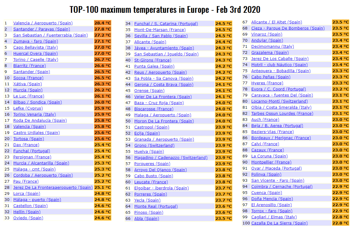
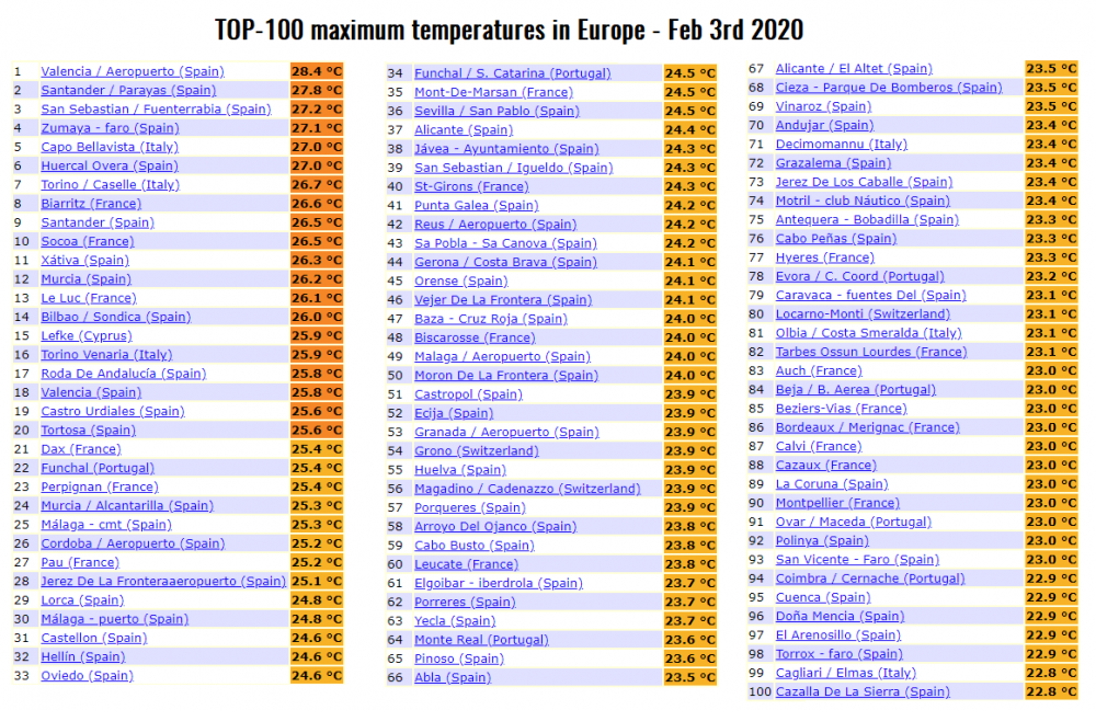
While we complain about our lack of winter weather these are high temperatures today across Europe. Many temperatures above 80 F.
-
Are you talking about the 966 mb low in the Gulf of Maine? It’s nothing more than a fantasy at this range.
-
The devil is in the details as they say (whoever they are). We are going to see 2 systems and we’re going to see almost every form of precipitation there is. What remains to be seen is the timing of the changeovers and where the back edge of the heavier precipitation from the second system sets up. Anyways it should be interesting.
-
This system never closes off at any level now and is basically a wave along the front. It zips from northern Virginia to exiting Maine in 12 hours.
-
I think it’s going to come down to how wound up this system gets. A wound up deeper storm will throw heavier snow back our way. A weaker wave will keep precipitation closer to the coast. The 12Z GFS has a 979 mb low over the Berkshires while 18Z has a strung out 980 something system over the coast.
-
You picked the hour where even the operational GFS has mixing almost into CNY. It’s hour 120 where the fun and games begin. What does the GEFS show then?
-
Maybe I will get to use my new snowblower!
-
Syracuse didn’t have any nights below zero in January. There were 6 nights with lows in the single digits with the lowest being 4 on the 21st.