CNY_WX
-
Posts
2,717 -
Joined
-
Last visited
Content Type
Profiles
Blogs
Forums
American Weather
Media Demo
Store
Gallery
Everything posted by CNY_WX
-

Major Winter Storm 2/6-2/7 OBS
CNY_WX replied to PaulyFromPlattsburgh's topic in Upstate New York/Pennsylvania
I just took a 6 hour snow measurement and got 4.8 inches. Added to 2.5 inches at 7 gives me 7.3 inches for the storm so far. The snow started around 5 AM so it’s been snowing for 8 hours which averages about an inch an hour. Snowfall intensity has decreased recently. -
Major Winter Storm 2/6-2/7 OBS
CNY_WX replied to PaulyFromPlattsburgh's topic in Upstate New York/Pennsylvania
Interesting visible satellite image of our storm. -
Major Winter Storm 2/6-2/7 OBS
CNY_WX replied to PaulyFromPlattsburgh's topic in Upstate New York/Pennsylvania
I’m trying to wait until 1 to take a 6 hour measurement but 7 inches sounds close. -
Major Winter Storm 2/6-2/7 OBS
CNY_WX replied to PaulyFromPlattsburgh's topic in Upstate New York/Pennsylvania
Flake size has gotten rather small which is hindering the accumulation. The visibility is still pretty low. -
Major Winter Storm 2/6-2/7 OBS
CNY_WX replied to PaulyFromPlattsburgh's topic in Upstate New York/Pennsylvania
Heavy snow here and at KSYR. Snow increased 1 inch in the last hour, 8 inches on the ground. KSYR 071454Z 28011KT 1/4SM R28/2000V2200FT +SN FZFG VV006 M04/M06 A2909 RMK AO2 SLP850 SNINCR 1/8 P0007 60022 T10441061 56029 -
Major Winter Storm 2/6-2/7 OBS
CNY_WX replied to PaulyFromPlattsburgh's topic in Upstate New York/Pennsylvania
The snow’s been somewhat variable in intensity. For a while it let up to about a mile visibility now it’s back to moderate to heavy snow. -
Major Winter Storm 2/6-2/7 OBS
CNY_WX replied to PaulyFromPlattsburgh's topic in Upstate New York/Pennsylvania
I think he’s looking for a dog sled to pull! -
Major Winter Storm 2/6-2/7 OBS
CNY_WX replied to PaulyFromPlattsburgh's topic in Upstate New York/Pennsylvania
It’s funny but the snowfall has really picked up in intensity but it doesn’t show up on radar. I’ve got to be closing in on 4 inches for the storm already. -
Major Winter Storm 2/6-2/7 OBS
CNY_WX replied to PaulyFromPlattsburgh's topic in Upstate New York/Pennsylvania
Flakes have gotten bigger here. Looks like another inch since 7. -
Major Winter Storm 2/6-2/7 OBS
CNY_WX replied to PaulyFromPlattsburgh's topic in Upstate New York/Pennsylvania
Ripping here! Nice sized flakes coming straight down. -
Major Winter Storm 2/6-2/7 OBS
CNY_WX replied to PaulyFromPlattsburgh's topic in Upstate New York/Pennsylvania
I woke up around 6:30 half expecting it to still be raining. I checked obs on my iPad and saw that from Syracuse west it had flipped over to snow but thought there would be a dusting at this point. I was really surprised when I came downstairs to see we had already gotten a couple inches. I just did the 7 AM measurement and I’ve received 2.5 inches already. Snowing pretty heavily right now and it’s only in the first quarter of this storm! -
Major Winter Storm 2/6-2/7 OBS
CNY_WX replied to PaulyFromPlattsburgh's topic in Upstate New York/Pennsylvania
Latest observation from KROC has snow starting to mix in. KROC 070354Z 04011KT 3SM -FZRAPLSN BR OVC005 M02/M03 A2939 RMK AO2 SNB42 SLP962 P0002 I1003 T10221033 -
Major Winter Storm 2/6-2/7 OBS
CNY_WX replied to PaulyFromPlattsburgh's topic in Upstate New York/Pennsylvania
What trends are you looking at? -
Major Winter Storm 2/6-2/7 OBS
CNY_WX replied to PaulyFromPlattsburgh's topic in Upstate New York/Pennsylvania
It flipped from ZR to IP to SN within 20 minutes in Niagara Falls around 7:30. Buffalo must be getting close. -
Major Winter Storm 2/6-2/7 OBS
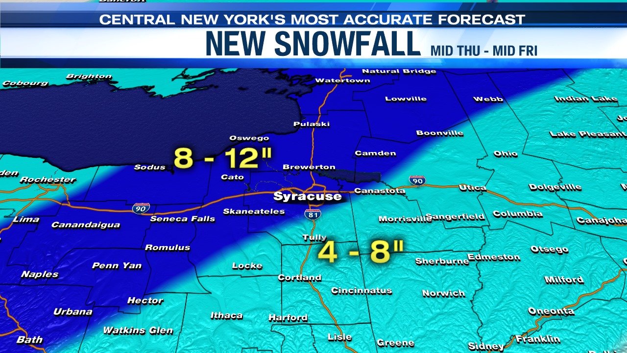
CNY_WX replied to PaulyFromPlattsburgh's topic in Upstate New York/Pennsylvania
Channel 9’s updated forecast. It includes the city of Syracuse in the 8-12 area.
-
Major Winter Storm 2/6-2/7 OBS
CNY_WX replied to PaulyFromPlattsburgh's topic in Upstate New York/Pennsylvania
Hopefully the sleet means the column is starting to cool. It’s snowing across the lake in Toronto. -
Major Winter Storm 2/6-2/7 OBS
CNY_WX replied to PaulyFromPlattsburgh's topic in Upstate New York/Pennsylvania
020 ...WINTER STORM WARNING IN EFFECT FROM 10 PM THIS EVENING TO MIDNIGHT EST FRIDAY NIGHT... * WHAT...Heavy mixed precipitation expected. Total snow accumulations of 6 to 9 inches and ice accumulations of up to one tenth of an inch. * WHERE...Seneca, Southern Cayuga, Onondaga, Tompkins, Madison and Cortland counties. * WHEN...From 10 PM this evening to midnight EST Friday night. We’re under a WSW and KBGM is calling for less snow than you! SMH -
Major Winter Storm 2/6-2/7 OBS
CNY_WX replied to PaulyFromPlattsburgh's topic in Upstate New York/Pennsylvania
I wonder if local media meteorologists will up their forecast amounts based on the 12Z runs. Right now most of them are calling for 4-8 inches after the changeover tomorrow morning. -
Major Winter Storm 2/6-2/7 OBS
CNY_WX replied to PaulyFromPlattsburgh's topic in Upstate New York/Pennsylvania
I’m sure downtown is a couple degrees warmer than the airport plus solar radiation is starting to become more significant since we’re a week into February. -
Major Winter Storm 2/6-2/7 OBS
CNY_WX replied to PaulyFromPlattsburgh's topic in Upstate New York/Pennsylvania
-
Major Winter Storm 2/6-2/7 OBS
CNY_WX replied to PaulyFromPlattsburgh's topic in Upstate New York/Pennsylvania
Did anyone die in that storm? I can’t imagine being lost outside in that. -
Major Winter Storm 2/6-2/7 OBS
CNY_WX replied to PaulyFromPlattsburgh's topic in Upstate New York/Pennsylvania
Like the blizzard that hit Newfoundland a couple of weeks ago? What was the lowest pressure in that cyclone? -
Major Winter Storm 2/6-2/7 OBS
CNY_WX replied to PaulyFromPlattsburgh's topic in Upstate New York/Pennsylvania
Even less reason to worry. -
Major Winter Storm 2/6-2/7 OBS
CNY_WX replied to PaulyFromPlattsburgh's topic in Upstate New York/Pennsylvania
Why are you worried in Rochester? There was always going to be taint tonight before the temperature crash. 6Z models are still showing the heaviest snow just to my East. If anything last night’s event was an over achiever. I got 4 inches when the forecast was 1-3. -
Major Winter Storm 2/6-2/7 OBS
CNY_WX replied to PaulyFromPlattsburgh's topic in Upstate New York/Pennsylvania
Moisture is streaming off of the Gulf of Mexico. Warnings (flash flood, severe thunderstorm) all over Alabama and Georgia this morning