CNY_WX
-
Posts
2,717 -
Joined
-
Last visited
Content Type
Profiles
Blogs
Forums
American Weather
Media Demo
Store
Gallery
Everything posted by CNY_WX
-
Every time the back edge approaches it back build over Cayuga County. If this keeps up there won’t be much of a break before the band over western New York gets here.
-
I wish they’d plow my street so I can snowblow my driveway and clean up what they’re going to push into the end.
-
It’s a wet snow starting to get the feel of spring snow.
-
Just measured 3.4 inches since 8:30 this morning to go along with 0.4 inch I measured then so 3.8 for the event so far. Still snowing.
-
This one is somewhat compensation for some of the low busts we’ve had recently.
-
I was going to mention that the returns taper off along a line that seems to correspond with the high point on the Tug.
-
Looks like orographic lift is occurring as air rises over the Tug.
-
Some back building over Cayuga County should keep the snow going a little while longer.
-
Still snowing but the back edge is on my doorstep. Burst of precipitation should move through later this afternoon. It will be interesting to see what form that’s in since my temperature is now up to 33. Then we do it all over again tomorrow morning, hopefully a repeat of the snow.
-
Still snowing hard here. Approaching 3 inches using my Weber grill measurement. It’s 3 inches from the top of the grill cover to the top of the handle and the handle has almost disappeared.
-
Been stuck at 28 since I got up just before 8. Snowing hard right now, coming straight down.
-
Been snowing moderate to heavy for the last hour. I’m a little disappointed with the accumulation of 0.4 inch on LE of 0.03. Flake size has been small up to this point but it seems to be picking up now.
-
The two big 40 inch storms in recent Syracuse history were 1966 and 1993. There were 27 years between the 66 storm and the 93 storm. It has now been 28 years since the 93 storm so maybe we’re due for another one.
-
During the winter of 1965-66, 42 of the 118 inches came during the Blizzard of 66. So only 76 inches fell during the rest of the winter.
-
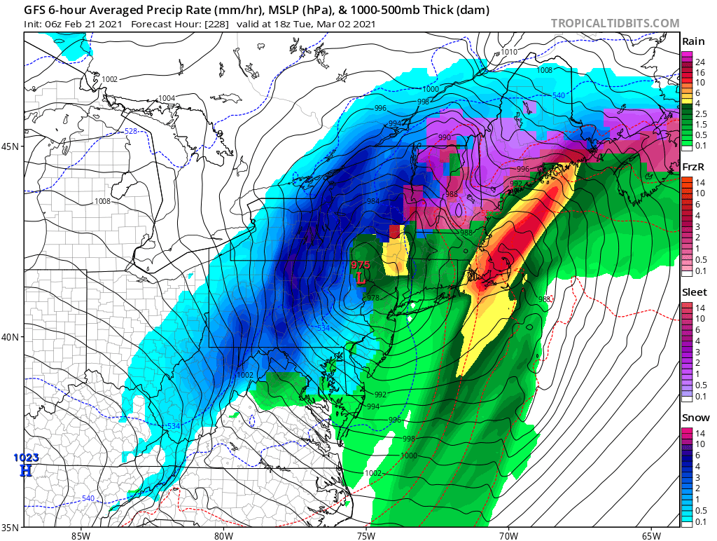
You must not have looked at the 12Z. Our blizzard is now a mix. Would you expect anything else?
-
Sorry Buffalo.
-
We can only dream...
-
SNOW SQUALL WARNING NWS BINGHAMTON NY 1257 PM EST SAT FEB 20 2021 NYC011-011-017-017-023-023-067-067-201900- /O.NEW.KBGM.SQ.W.0002.210220T1757Z-210220T1900Z/ 1257 PM EST SAT FEB 20 2021 Cayuga County-Chenango County-Cortland County-Onondaga County- The National Weather Service in Binghamton has issued a * Snow Squall Warning for... Southern Cayuga County in central New York... Cortland County in central New York... Southwestern Onondaga County in central New York... Northern Chenango County in central New York... * Until 200 PM EST. * At 1257 PM EST, a dangerous snow squall was located along a line extending from Tully to Fleming, moving southeast at 25 mph. HAZARD...Very poor visibility in heavy snow and blowing snow. Wind gusts up to 30 mph. SOURCE...Radar indicated. IMPACT...Dangerous life-threatening travel. Locations impacted include... Cortland, Norwich, Owasco, Homer, Fleming, Otisco, Preble, Moravia, Niles and Scott. This includes the following highway exits... New York Interstate 81 between 10 and 14.
-
Are you on County Line Road? My nephew used to live there.
-
Were you wearing your shorts?
-
You are in the middle of this band. I get a few flakes once in a while then the sun comes out.
-
Say goodbye to any major snowfalls, lol.
-
-
We got our usual scraps overnight. 2.2 inches on 0.08 LE. Our Lake Ontario band seems to be evolving into a spray of snow. It’s snowing lightly here again.
-
Beautiful parachutes floating straight down. Not the main event according to Jim Teske on channel 9 but we’ll take whatever we can get.