CNY_WX
-
Posts
2,717 -
Joined
-
Last visited
Content Type
Profiles
Blogs
Forums
American Weather
Media Demo
Store
Gallery
Everything posted by CNY_WX
-

Upstate/Eastern New York-Into Winter!
CNY_WX replied to BuffaloWeather's topic in Upstate New York/Pennsylvania
What did you really expect this early in the season down here on the lake plain? It was pretty obvious the bulk of the lake effect was going stay north of here and our temperatures were just too warm. -
Upstate/Eastern New York- Meteorological Fall
CNY_WX replied to BuffaloWeather's topic in Upstate New York/Pennsylvania
0.68 inch here. Looking at the CoCoRaHS reports the Finger Lakes up through the Rochester area got 2 inches plus. -
Upstate/Eastern New York- Meteorological Fall
CNY_WX replied to BuffaloWeather's topic in Upstate New York/Pennsylvania
Carol’s house? -
Upstate/Eastern New York- Meteorological Fall
CNY_WX replied to BuffaloWeather's topic in Upstate New York/Pennsylvania
Obviously left over from the communist days. I’m surprised they’re still there. -
Upstate/Eastern New York- Meteorological Fall
CNY_WX replied to BuffaloWeather's topic in Upstate New York/Pennsylvania
Lake effect behind the system on the GFS. Rain on the lake plain, sorry Matt!
-
Upstate/Eastern New York- Meteorological Fall
CNY_WX replied to BuffaloWeather's topic in Upstate New York/Pennsylvania
My thermometer recorded a low of 33 but there still was no frost this morning. As for the storm next weekend (11/5-6), the GFS has a rain system passing across southern New England on Friday that redevelops in the GOM. All we get is some lake effect in it’s wake. -
Upstate/Eastern New York- Meteorological Fall
CNY_WX replied to BuffaloWeather's topic in Upstate New York/Pennsylvania
1.98 inches in my rain gauge this morning. Along with 0.68 inch yesterday morning the storm total here was 2.66 inches. That would have been almost 27 inches of snow at 10:1. -
Upstate/Eastern New York- Meteorological Fall
CNY_WX replied to BuffaloWeather's topic in Upstate New York/Pennsylvania
Same here. Edit: Since midnight the range has been 52-54. -
Upstate/Eastern New York- Meteorological Fall
CNY_WX replied to BuffaloWeather's topic in Upstate New York/Pennsylvania
Another 0.35” since 8:15. If this was snow with decent ratios it would be coming down at almost 2 inches per hour. I’m over an inch for the storm so far. -
Upstate/Eastern New York- Meteorological Fall
CNY_WX replied to BuffaloWeather's topic in Upstate New York/Pennsylvania
I had 0.68” as of 8:15 AM. Channel 9’s timecast has the rain continuing until midnight . -
Upstate/Eastern New York- Meteorological Fall
CNY_WX replied to BuffaloWeather's topic in Upstate New York/Pennsylvania
I moved from Little Falls to Brewerton in November, 1995. That is still the snowiest November on record in Syracuse. I closed on my house on November 9. Closing was scheduled for 10 AM. As I drove up the Thruway I encountered heavy snow around Chittenango. I had a Suzuki Sidekick at the time so I did have 4 wheel drive but going was still extremely slow. I was panicking that I was going to be late for the closing. I made it there about 10:30 and was the first one there! Ended up with about 8 inches for that event Heavy lake effect events continued into December I think the pattern flipped in January -
Upstate/Eastern New York- Meteorological Fall
CNY_WX replied to BuffaloWeather's topic in Upstate New York/Pennsylvania
My thermometer reported a low of 32 but there wasn’t any frost this morning unless it melted before we got up. -
Upstate/Eastern New York- Meteorological Fall
CNY_WX replied to BuffaloWeather's topic in Upstate New York/Pennsylvania
34 at 10 PM and we didn’t even end up with frost here in Brewerton. Clouds moved in overnight and the temperature was up to 37 by midnight. In the low 40s this morning. Somebody must have left a door open in Sizzlecuse and some of the heat escaped. -
Upstate/Eastern New York- Meteorological Fall
CNY_WX replied to BuffaloWeather's topic in Upstate New York/Pennsylvania
Struggled to lose another degree in the last 2 hours, currently at 34. There’s a few clouds overhead but Jupiter still shines brightly in the southwestern sky. -
Upstate/Eastern New York- Meteorological Fall
CNY_WX replied to BuffaloWeather's topic in Upstate New York/Pennsylvania
35 degrees at 9:30. Could be looking at the first freezing temperature of the season overnight. -
Upstate/Eastern New York- Meteorological Fall
CNY_WX replied to BuffaloWeather's topic in Upstate New York/Pennsylvania
I turned my heat on yesterday. It was about 65 and the house had that damp feeling. My wife had her Covid booster Saturday and she was complaining about being cold so I caved. I looked at the radar about an hour ago and thought we might be getting a break from the rain but the rain that was north of here has dropped south. So sick of this, it’s like Chinese water torture. My yard is like the Cicero swamp. -
Upstate/Eastern New York- Meteorological Fall
CNY_WX replied to BuffaloWeather's topic in Upstate New York/Pennsylvania
That was the second tornado warning in 12 hours in basically the same location. We should be looking at frost and freeze advisories this time of year. -
Upstate/Eastern New York- Meteorological Fall
CNY_WX replied to BuffaloWeather's topic in Upstate New York/Pennsylvania
This is the storm with the radar indicated tornado. -
Upstate/Eastern New York- Meteorological Fall
CNY_WX replied to BuffaloWeather's topic in Upstate New York/Pennsylvania
Can this be attributed to a difference with the timing of the cold front? Euro does show colder temperatures just off to the west. What does hour 132 show? -
A “Great Red Spot” on Earth?
-
Upstate/Eastern New York- Meteorological Fall
CNY_WX replied to BuffaloWeather's topic in Upstate New York/Pennsylvania
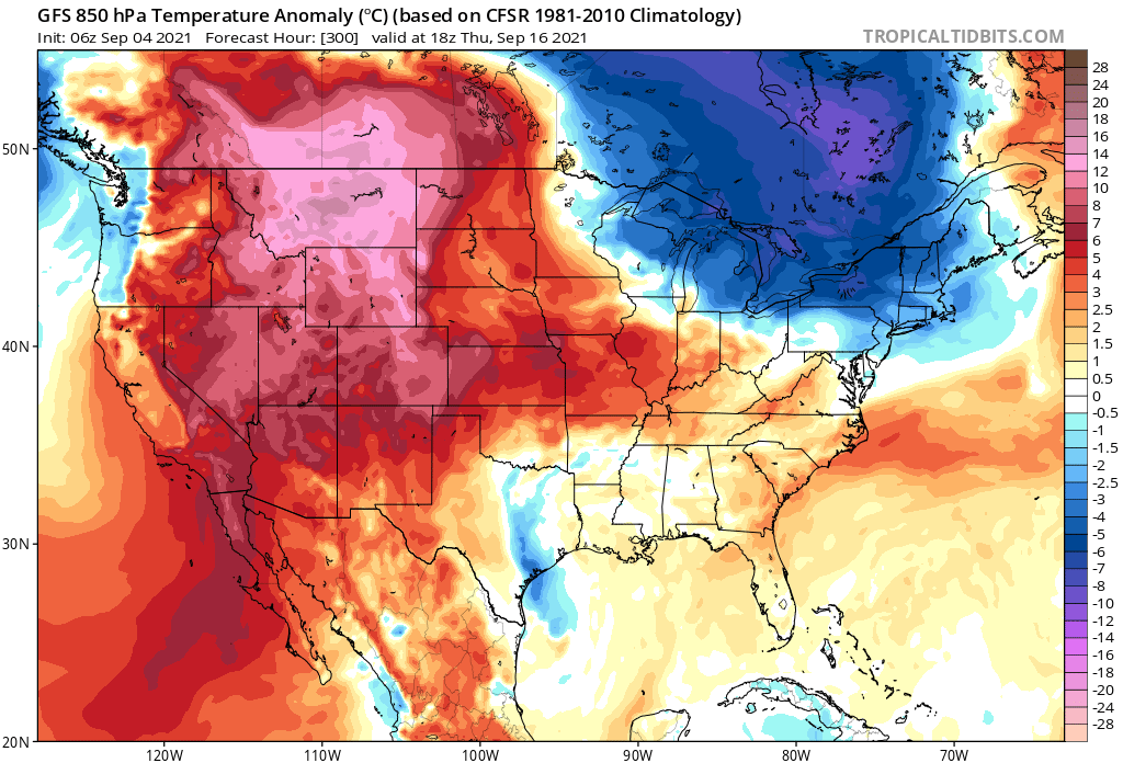
This is the same time period on this morning’s 6Z run. What happened to the sizzle?
-
Upstate/Eastern New York- Meteorological Fall
CNY_WX replied to BuffaloWeather's topic in Upstate New York/Pennsylvania
That’s the GFS at 318 hours, I wouldn’t be making any plans based on it. -
Upstate/Eastern New York- Meteorological Fall
CNY_WX replied to BuffaloWeather's topic in Upstate New York/Pennsylvania
Final numbers are in for meteorological summer in Syracuse. Just as we thought it was warm and wet.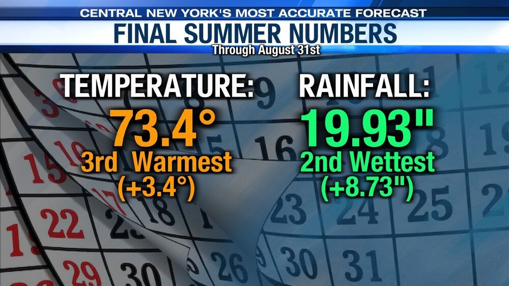
-
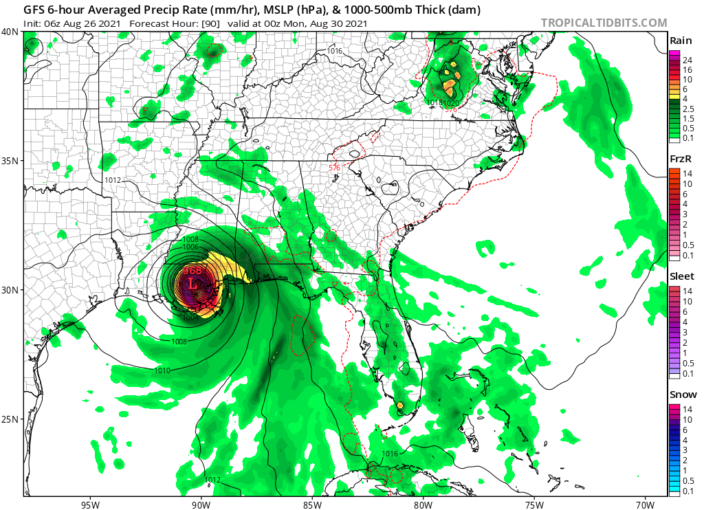
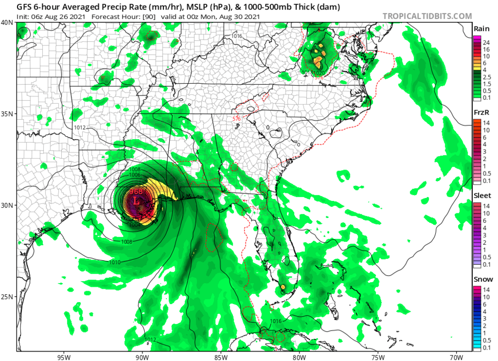
It looks like New Orleans will be in the sight of this tropical system on Sunday if the GFS verifies. Big test of the levees.
-
There goes Sunday’s Yankee game. That has to be on the western edge of all the guidance although the trend has been further west.