tacoman25
-
Posts
4,958 -
Joined
-
Last visited
Content Type
Profiles
Blogs
Forums
American Weather
Media Demo
Store
Gallery
Everything posted by tacoman25
-
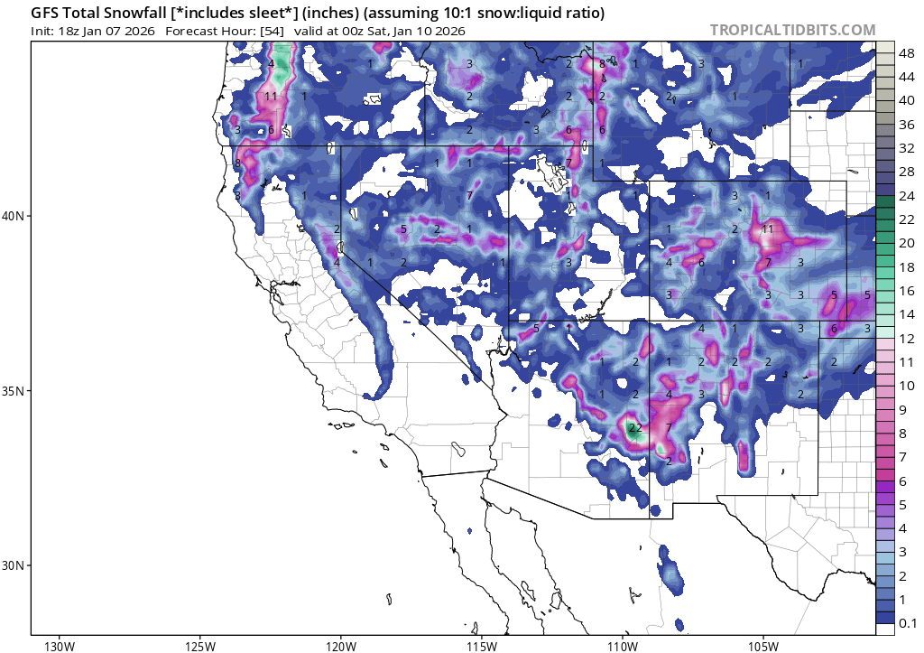
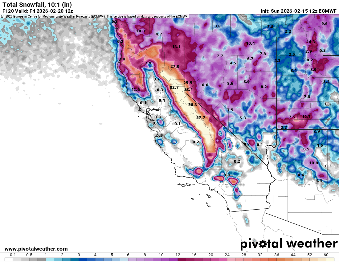
The Sierras are about to get pounded.

-
Yeah, the mountains could desperately use the pattern change.
-
Last couple weeks was actually below normal here, first time this fall/winter we've had such a period. Obviously not nearly as cold as they were in the Midwest and East. But the overall winter pattern has been very similar to 1980-81, also weak -ENSO and dominated by ridging west/cold east.
-
Picked up 1.5" in a couple hours here. Pretty dramatic temp drop too as the front came through around 2:30. Went from 26 to 13 in about an hour. Still snowing decently even though radar doesn't show much.
-
Phoenix's expanded UHI is clearly skewing their numbers towards more record warm months. Flagstaff is currently not close to their warmest Jan on record, which was 2003.
-
Yeah, bummer we don't have anything big to track here, but I'm just grateful we've finally turned the corner on the nearly unabated torch that the first half of winter brought. The next week has really trended colder from how it looked a few days ago. Now hopefully we'll get a little more snow to go with it.
-
Got a little over an inch here. At 13" for the season. I believe 2010-11 was similarly sad for snowfall at this point. Have to admit, it was the East's turn.
-
Looks like we get a little snow tonight.

-
Mmmk. Live by the sword, die by the sword. If you want to count on AGW driving monthly anomalies, you also have to account for when a Feb 2021 happens. FWIW, I think a top 5 warmest January in the U.S. is highly unlikely. Just looking at the blocking in AK.
-
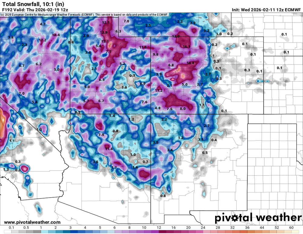
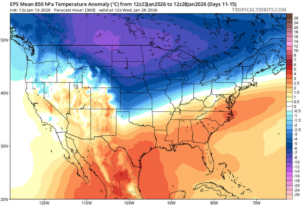
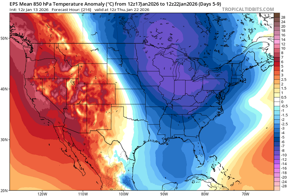
Very warm pattern to start the month, but that's about to change. AK and the Yukon are finally warming up, and that means colder air finally allowed to spill down into the lower 48 again. Map will look much different in 10 days.

-
That's fair, but your first statement was about this last event busting. Which wasn't the case, at least for most of the Denver area. It was never forecast to be a big storm.
-
I mean...most of Denver metro was expected to get 1-4" and that happened? With a few places in SW metro getting more.
-
That makes things easier, huh? But was he wrong?
-
Lol, ended up with almost 4" here. On the high end of what most models showed 24 hours out.
.thumb.jpg.9f61f57319b24a3710f48d24de42e97f.jpg)
-
Yeah, this one's looking like a bust. Got a couple brief snow showers this am that amounted to about 1/4", and now it's looking like the second part of the system that was supposed to deliver the heavier stuff overnight is drifting more to the south.
-
Yeah, those trying to use flooding pics in Miami as an example of sea level rise and climate change are being completely dishonest and/or patently doomers. And yes, if some in this thread want to label us "deniers", I'm going to label them doomers. Fair is fair.
-
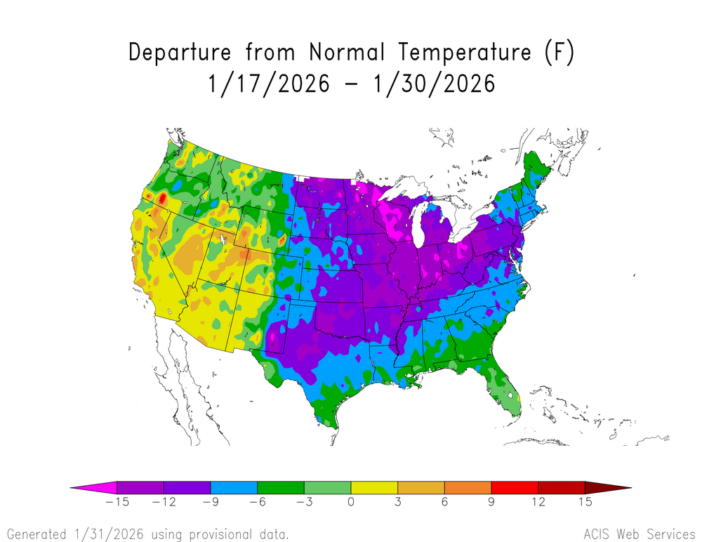
Yes, and as I pointed out, it wasn't just comparing the magnitude of the extremes on both sides, it was the geographic extent as well. Most of Canada, a huge country, was well below normal last month.
-
0z Euro looks basically the same as 12z. Looks like there will be snow tomorrow for a few hours, then a lull, then it picks up again in the evening for a few hours. 2-4" for Denver metro south of 70 still appears on track.
-
Latest GFS goes nuts. NAM trended wetter, too. Have to think this is overdone, though.

-
Eh, last couple snow events ended up about where the models were showing 24 hours out. At least here. In early December I actually got an inch or two more than was expected. Most are still showing 1-4" for Denver metro as of now, so I think that's a pretty good bet. Main limiting factor looks to be heaviest precip occurring during the middle of the day with peak heating.
-
Sure, but a 30 year period is standard for anomalies. So my statement stands. And it's also only fair to acknowledge how much larger that area of extreme cold anomalies in NW Canada/AK was. Canada saw their coldest December temp in 50 years last month: https://nationalpost.com/opinion/canadas-coldest-temperature-in-50-years That's a whole country. It was objectively an impressive and extremely cold period up north, no reason to downplay this.
-
Lame cop out. Who here has "denied" climate change is happening? Some of you think that if people aren't freaking out and claiming the world is ending due to climate change, they're deniers. It's not that binary, that's not reality. "Oh no, someone pointed out that it's not record heat everywhere, all the time - they are a clearly a DENIER! Burn them at the stake."
-
Yeah, that really captures it. The extreme cold was greater than the extreme warmth, as far as anomalies go.
-
All models are now pretty much in agreement for a 2-4" event for the metro area Thursday afternoon and night. With higher amounts possible further south.
-
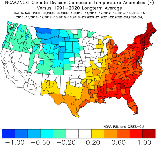
Really depends on the location. Boulder saw their snowiest winter on record in 2019-20, and the last decade has been snowier there than the 1980s were. But yeah, this pattern has been the worst. At least it looks like we may get some snow in a few days.


.jpg.708309db398b7ff720c3b2a88b31a90e.jpg)