

SchaumburgStormer
-
Posts
5,281 -
Joined
-
Last visited
Content Type
Profiles
Blogs
Forums
American Weather
Media Demo
Store
Gallery
Posts posted by SchaumburgStormer
-
-
Just now, CoalCityWxMan said:
Major changes occurred 12 hours before onset of the last system, nothing is set in stone just yet
Don’t exactly need a “major” change to bring 88 north back into the game.
That being said, not holding my breath for much more than an advisory nusciance event here.
-
 1
1
-
-
What a complete waste of a sweet setup. I may end up with 4-6”, but pales to what could have been.
-
 1
1
-
 1
1
-
-
Things really got out of hand. Dropped to -24, -23 currently
-
Pack er up

-
1
-
1
-
-
13 minutes ago, CoalCityWxMan said:
21z SREF plumes are a touch south of 15z
Snowfall lower on the 21z
-
Just now, Stebo said:
At 69 it almost turns into a squall line of snow


-
1
-
-
Just now, Stebo said:
The bleeding definitely stopped on that run, though the evolution is a bit NAMish.
Definitely some strange surface action happening once it gets out of IA
-
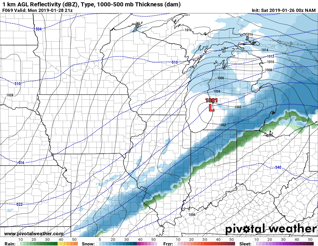
Just now, SchaumburgStormer said:
Definitely south. Over Galena at hr 60
Then rides due east along the state line.
-
13 minutes ago, Chicago Storm said:
The combination of the PV lobe south of the Hudson being further west, plus the wave/storm faster and a bit south likely means this run comes in south overall with the system.
Definitely south. Over Galena at hr 60
-
2 minutes ago, Indystorm said:
IND calling for rain and high near 40 Monday. Wagons north!
Been a non winter event for your back yard for awhile now.
-
1
-
-
1.0” here on the clipper.
And since we are throwing it out there, I just celebrated my 32nd anniversary of the great womb escape.
-
1
-
-
9 minutes ago, StormChaser4Life said:
Cyclone you need to share the love. You have cashed in on almost every storm. Lol
You must not have been here when cyclone suffered through the “great 6” drought”
-
2
-
3
-
-
Just now, CoalCityWxMan said:
It’ll be interesting to see what GEFS members do. My guess is they move north but will be interested to see if there’s still a large spread
3rd and long. Euro a south outlier, but I suppose that if we need one for our team, it’s a good one.
-
1
-
-
42 minutes ago, CoalCityWxMan said:
Has been snowing for 20 minutes in DKB and (well salted) roads are already snow covered. Even though amounts will be in the 1-3” range in the area it could be an awful evening commute.
Roads went to shit quickly. Even the dusting on them is really making things slick. Drove back from Geneva, and ran into the snow. You would have thought it was the first snow of the season the way people were spinning out
-
Just now, beavis1729 said:
Right...and it means that the furthest south of all models is now tracking the low over the IL/WI state line. Not good trends for the Chicago area. In addition to missing out on the heaviest QPF axis, the ratios will be much worse, since temps won't be as cold. If trends continue, Chicago will be lucky to see 2" out of this, with temps warming into the 30s after the snowfall.
What used to be a clipper parade has now turned into essentially one meaningful clipper...and now this one clipper may not even produce...and now the arctic outbreak next week is being muted. Not a good day for winter weather lovers here. Better in MN/WI.
It’s second down. No punting yet. Wait till this sucker is at least partially sampled.
-
1
-
 1
1
-
-
Models playing the “lets all shift north at 48 hrs out” game. Hoping to see a correction south as we have with the other storms.
Should have some sampling tonight correct?
NAM takes the low wayyy north, track it over MSN. Not putting stock into it, but another piece for the north trend overnight.
-
2
-
-
5 minutes ago, Hoosier said:
Meh, imo they don't count lol. I'm talking Rockford, Moline, Chicago... the big boys.
Hahaha, all reporting sites considered, RPJ is going to set the bar. -30 or bust.
-
Just now, Hoosier said:
Sort of looks like it's in between the 12z and 18z runs.
Taking the low right over DKB
-
8 minutes ago, Baum said:
thought the same thing based on today's results. That's why I've always loved these clipper/northwest flow regimes..
This high ratio stuff is always fun, simply because it looks awesome. Classic winter as those puffballs are falling. Just the couple hours of flurries/-sn was great for the winter lovers mood today.
As RC mentioned, any light snow is going to accumulate effectively. A burst of moderate snow over the metro during the rush will be enough to paralyze traffic. A lot of the country roads out here are already snow covered due to blowing/drifting.
-
2
-
-
Considering we are still a good ways out and within an envelope of 100ish miles, that’s a good signal.
I would be cautiously optimistic if you are sitting north of I-80 to the WI border in IL. The real question is can this storm tap its full potential. Do we have a high end hybrid clipper, or one we can add to the “top storms” list.
-
2
-
-
1 hour ago, Chambana said:
Yeah. Same. 1-2” looks good.
Yep, and have hit the point where even nusciance snow makes the roads go to hell in a hurry
-
25 minutes ago, Hoosier said:
What is that even? Like a 1 in 200 year event? Even more rare?

That’s “glacier flattening the land” cold.
-
2
-
-
2 hours ago, SchaumburgStormer said:
Underestimated my “eyeball” guess by quite a bit. Measured 4.4” IMBY, still snowing lightly.
Nice little suprise considering Hi-Res runs from 24 hours ago had the rain/snow line slamming north of me.
Interesting to note, we definitely flipped to rain/drizzle sometime overnight. On my “big board” (aka the one I don’t clear), I have about 1.5-1.6”, icy crust, then another 2.5-2.6”
-
8 hours ago, cyclone77 said:
If the new Euro is correct we'd be looking at potential snow depth records around here, as there's already a good 8-12" (counting tonight's snows) on the ground.
...Camera pans, man sitting next to roaring fireplace smoking a pipe, peering over his snow covered yard...
“We had a few rough years, but that’s in the past now.”
(Cyclone pats the snow magnet he secured during a dangerous trek to Mt Geos)
“Snow depth record, here we come” (cranks magnet to 11)
-
5
-
1
-
7
-
Hybrid Clipper Event 1/27-1/29
in Lakes/Ohio Valley
Posted
Big dogs or bring on golfing weather.