SchaumburgStormer
-
Posts
5,527 -
Joined
-
Last visited
Content Type
Profiles
Blogs
Forums
American Weather
Media Demo
Store
Gallery
Everything posted by SchaumburgStormer
-

January 10th-12th Winter Storm Potential
SchaumburgStormer replied to Thundersnow12's topic in Lakes/Ohio Valley
Low track is further south than the last run. Edit: disregard. Ends up pretty close to earlier run. -
January 10th-12th Winter Storm Potential
SchaumburgStormer replied to Thundersnow12's topic in Lakes/Ohio Valley
Euro is going to be an ice crush job for N IL -
January 10th-12th Winter Storm Potential
SchaumburgStormer replied to Thundersnow12's topic in Lakes/Ohio Valley
-
January 10th-12th Winter Storm Potential
SchaumburgStormer replied to Thundersnow12's topic in Lakes/Ohio Valley
Don't get me wrong, it would be epic. But I don't trust the GFS at all at this point. But interesting to see what the rest of the 12z suite will show now that we have some sampling. -
January 10th-12th Winter Storm Potential
SchaumburgStormer replied to Thundersnow12's topic in Lakes/Ohio Valley
GFS is trying to throw 1+" of ice followed by 12" of snow for MBY. Not going to happen. -
January 10th-12th Winter Storm Potential
SchaumburgStormer replied to Thundersnow12's topic in Lakes/Ohio Valley
Low slows way down, able to take a STL to SBN path. Ice Ice Baby for IL. -
January 10th-12th Winter Storm Potential
SchaumburgStormer replied to Thundersnow12's topic in Lakes/Ohio Valley
-
January 10th-12th Winter Storm Potential
SchaumburgStormer replied to Thundersnow12's topic in Lakes/Ohio Valley
Sleet all the way to MKE -
January 10th-12th Winter Storm Potential
SchaumburgStormer replied to Thundersnow12's topic in Lakes/Ohio Valley
Storm seems to spend forever waiting to eject in Mexico. -
January 10th-12th Winter Storm Potential
SchaumburgStormer replied to Thundersnow12's topic in Lakes/Ohio Valley
NAM diving deep. Going to grab some tacos. -
January 10th-12th Winter Storm Potential
SchaumburgStormer replied to Thundersnow12's topic in Lakes/Ohio Valley
Classic low placement for siggy snows in MBY/RFD. (and hell, ORD with a decent cold air mass in place). Lets see what holds when we are sampled. -
January 10th-12th Winter Storm Potential
SchaumburgStormer replied to Thundersnow12's topic in Lakes/Ohio Valley
That backside defo would lay a quick few inches in N IL. Nice accums in SE IA -
January 10th-12th Winter Storm Potential
SchaumburgStormer replied to Thundersnow12's topic in Lakes/Ohio Valley
-
January 10th-12th Winter Storm Potential
SchaumburgStormer replied to Thundersnow12's topic in Lakes/Ohio Valley
Models showing a the changeover zone basically directly overhead for mby. N half of DKB county buried, S half rainer. -
January 10th-12th Winter Storm Potential
SchaumburgStormer replied to Thundersnow12's topic in Lakes/Ohio Valley
Respectable defo band shown on the backside with it still snowing in N IL at the end of the run. -
January 10th-12th Winter Storm Potential
SchaumburgStormer replied to Thundersnow12's topic in Lakes/Ohio Valley
1002mb over STL at the end of the run, likely to make a beeline towards BMI. Rainer fo sho. -
January 10th-12th Winter Storm Potential
SchaumburgStormer replied to Thundersnow12's topic in Lakes/Ohio Valley
-
January 10th-12th Winter Storm Potential
SchaumburgStormer replied to Thundersnow12's topic in Lakes/Ohio Valley
Would be nice if we sneak one of those siggy storms that looks better and better as the runs continue through the storm. But fully expecting this to *SouthParkAndItsGone.gif* -
January 10th-12th Winter Storm Potential
SchaumburgStormer replied to Thundersnow12's topic in Lakes/Ohio Valley
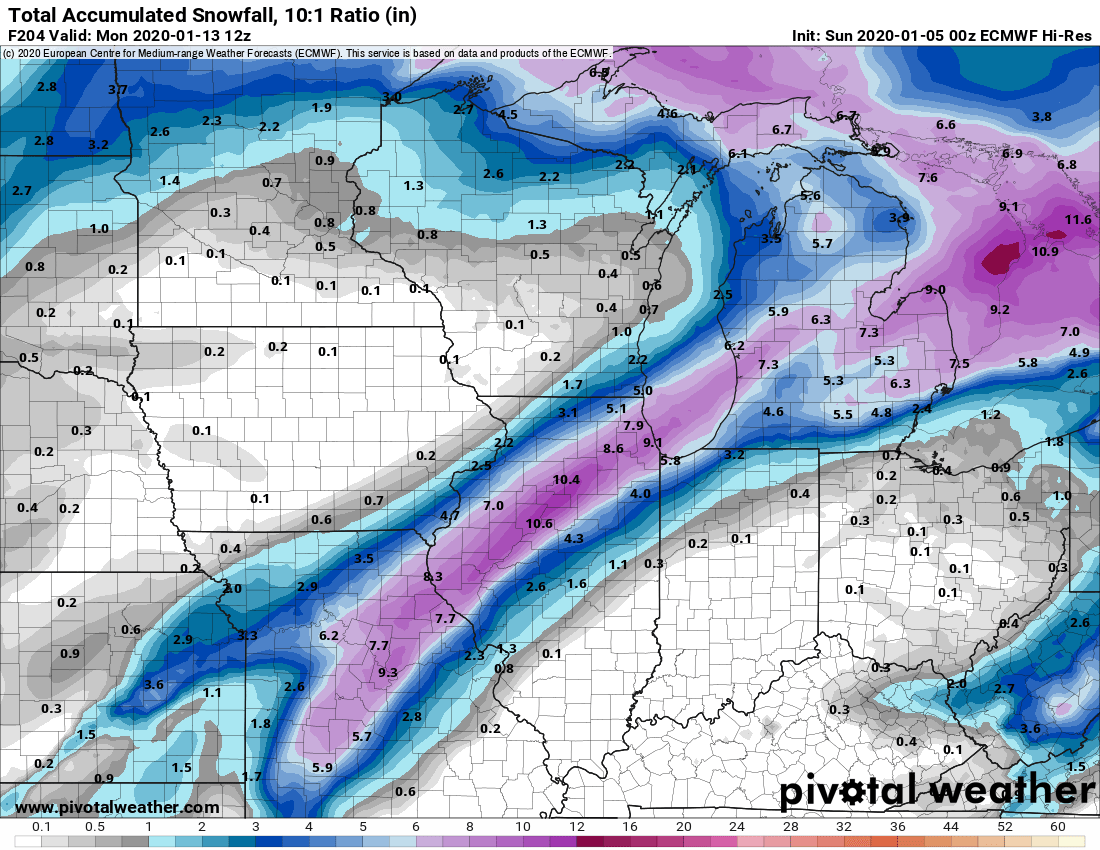
For posterity... -
January 10th-12th Winter Storm Potential
SchaumburgStormer replied to Thundersnow12's topic in Lakes/Ohio Valley
That backside slug of snow on the Euro would be rocking. -
Winter 2019-20 Medium/Long Range Discussion
SchaumburgStormer replied to Hoosier's topic in Lakes/Ohio Valley
Seems to be slower as well, but I am admittedly grasping at straws at this point. -
Winter 2019-20 Medium/Long Range Discussion
SchaumburgStormer replied to Hoosier's topic in Lakes/Ohio Valley
Euro joining the north camp. -
Winter 2019-20 Medium/Long Range Discussion
SchaumburgStormer replied to Hoosier's topic in Lakes/Ohio Valley
-
Winter 2019-20 Medium/Long Range Discussion
SchaumburgStormer replied to Hoosier's topic in Lakes/Ohio Valley
Lock er in.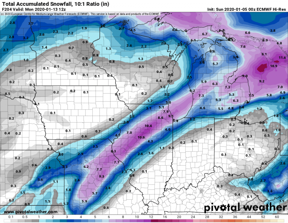
-
Winter 2019-20 Medium/Long Range Discussion
SchaumburgStormer replied to Hoosier's topic in Lakes/Ohio Valley
Winter cancel