SchaumburgStormer
-
Posts
5,528 -
Joined
-
Last visited
Content Type
Profiles
Blogs
Forums
American Weather
Media Demo
Store
Gallery
Everything posted by SchaumburgStormer
-
300hrs with no accumulation is less than desired
-

Winter 2022/23 Lake Effect Snow Thread
SchaumburgStormer replied to Chicago Storm's topic in Lakes/Ohio Valley
Straight firehose -
Winter 2022/23 Short/Medium Range Discussion
SchaumburgStormer replied to Chicago Storm's topic in Lakes/Ohio Valley
18z GFS wraps the warm tongue of death alllll the way around -
Winter 2022/23 Short/Medium Range Discussion
SchaumburgStormer replied to Chicago Storm's topic in Lakes/Ohio Valley
Big ole defo band just sits over N IL and pukes snow for 15 hours straight. Probably not happening but fun to see.
-
Nice burst of SN/+SN just rolled through. Feels like mid-January.
-
Winter 2022/23 Short/Medium Range Discussion
SchaumburgStormer replied to Chicago Storm's topic in Lakes/Ohio Valley
She’s a beaut.
-
Balling in BUF. Going to be wild out there Once this band sets up, it will remain fairly stationary late Thursday night and through the day Friday with the synoptic pattern forcing a general southwest flow. The strong convergence leading to impressive omega values, along with deep moisture in the snow DGZ and lake induced equilibrium levels rising to over 20K feet will allow this band of snow oriented along the long axis of the lake to become very strong with snowfall rates up to 3 inches per hour. Seeing how this narrow, intense band of snow will not oscillate much later Thursday night and through Friday and into Friday night snowfall totals will easily reach several feet this period. The highest totals may very well end up across the Buffalo Metro area, including downtown and towards the airport where a 240 wind flow will direct the snowband.
-
Had a solid 1.5-2” this morning, pretty much all melted now. My little guy got to go play in the snow with his Tonka trucks this morning, so I consider this storm a big win.
-
Hopefully it’s at least serviceable this winter season. It performance since the big upgrade has been, at least anecdotally, abysmal.
-
Recon showing expansive wind field on the N side of the storm. So with the current track, not an unreasonable forecast
-
Sitting in the United lounge at ohare getting drunk waiting to board a plane. Trying to get flights out today is a pipe dream
-
I didn’t realize how bonkers the drought was until I started looking at river levels for the Mississippi.
-
Wow, hit 26 here. Slammed the door on the growing season.
-
Long duration big dog going non-stop during the daytime hours. GHD 2 for example.
-
Fall 2022 Medium/Long Range Discussion
SchaumburgStormer replied to Chicago Storm's topic in Lakes/Ohio Valley
That's a rather improbable scoop and score for that trough. -
2022 Short/Medium Range Severe Weather Discussion
SchaumburgStormer replied to Chicago Storm's topic in Lakes/Ohio Valley
Several radar confirmed tornados according to the warning -
900 homes? 15-20 minute job on the media timeline
-
Very high population density and popular with retirees. I imagine we will see significant fatalities, but hopefully “hundreds” is an overestimate
-
PDS flash flood emergency, don’t see that combo too often. This is a FLASH FLOOD EMERGENCY for South central Sarasota county, southeast Manatee, northwest Desoto, Hardee, and northwest Highlands counties. This is a PARTICULARLY DANGEROUS SITUATION. SEEK HIGHER GROUND NOW!
-
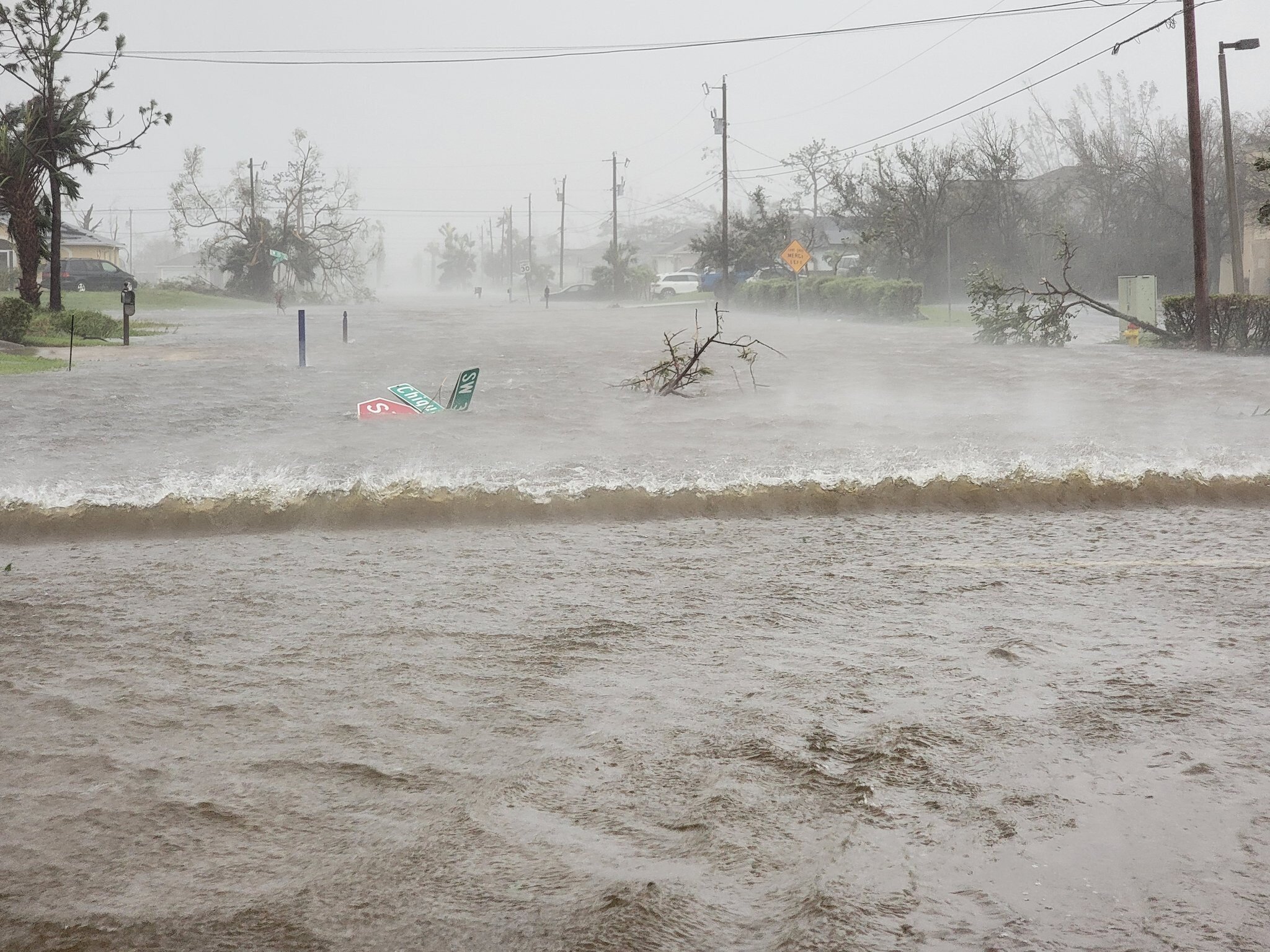
Southwest Cape Coral
-
Can see the wind shift coordinating with the surge drop. https://tidesandcurrents.noaa.gov/stationhome.html?id=8725520 May have shifted just enough to pile the water elsewhere
-
From the flooding impacts section - 10ft - The Barrier Islands are overtopped with 5 to 10 feet of water. Much of Cape Coral and Harlem Heights under 1 to 5 feet of water. More homes along the Caloosahatchee River, Orange River, and portions of Palm Beach Road are flooded. Portions of Bayshore road north of the Caloosahatchee River under 1 to 3 feet of water.
-
Rising at about 2ft an hour right now.
-
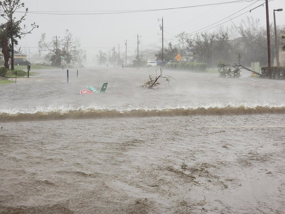
Twitter photo supposedly from Cape Coral
-
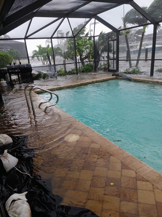
Not sure how high this cam is mounted, but SurgeCam9 is being overtaken by waves.