SchaumburgStormer
-
Posts
5,528 -
Joined
-
Last visited
Content Type
Profiles
Blogs
Forums
American Weather
Media Demo
Store
Gallery
Everything posted by SchaumburgStormer
-

Jan 28-29th Baroclinic Rider
SchaumburgStormer replied to Chicago Storm's topic in Lakes/Ohio Valley
Eh, actually about the same as 18z. A bit wetter. Has the best shows at the border and north -
Jan 28-29th Baroclinic Rider
SchaumburgStormer replied to Chicago Storm's topic in Lakes/Ohio Valley
Euro gonna be north too -
Jan 28-29th Baroclinic Rider
SchaumburgStormer replied to Chicago Storm's topic in Lakes/Ohio Valley
It’s had the weeble-wobbles for sure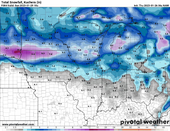
-
Jan 28-29th Baroclinic Rider
SchaumburgStormer replied to Chicago Storm's topic in Lakes/Ohio Valley
NAM going to jackpot MSN -
Jan 28-29th Baroclinic Rider
SchaumburgStormer replied to Chicago Storm's topic in Lakes/Ohio Valley
I feel like anecdotally, the warm front/surge seems to get held up quite often along I-80/southern tip of Lake Michigan. Wouldn’t surprise me if that’s a big demarcation line. (Zero meteorological reasoning behind this thought, fyi) -
Jan 28-29th Baroclinic Rider
SchaumburgStormer replied to Chicago Storm's topic in Lakes/Ohio Valley
Would love to be in Rockford, but I am thinking 88 and north ends up solid. -
Jan 28-29th Baroclinic Rider
SchaumburgStormer replied to Chicago Storm's topic in Lakes/Ohio Valley
Liking my area. Starting to think we will see a significant gradient across DeKalb/Cook County from N to S -
Jan 28-29th Baroclinic Rider
SchaumburgStormer replied to Chicago Storm's topic in Lakes/Ohio Valley
Geos years were the true NW trend years. -
Jan 28-29th Baroclinic Rider
SchaumburgStormer replied to Chicago Storm's topic in Lakes/Ohio Valley
Some solid messaging given the potential and uncertainty. -
Jan 28-29th Baroclinic Rider
SchaumburgStormer replied to Chicago Storm's topic in Lakes/Ohio Valley
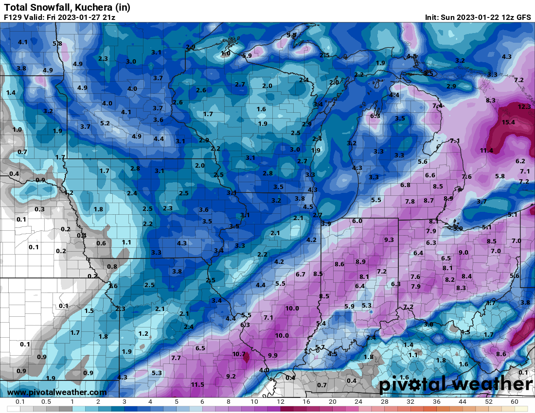
06z GFs is a bit south, snow I-80 to WI Border 12z Nam North and a bit more widespread, I-88 well into WI 06z Euro is North and narrow, snow from I-88 to Janesville, WI Other foreign is I-80ish well into WI Going to be a real shit show forecast for LOT with these tiny wobbles in track making significant sensible impacts throughout the metro. -
Jan 28-29th Baroclinic Rider
SchaumburgStormer replied to Chicago Storm's topic in Lakes/Ohio Valley
If I was betting on a shift, South wouldn’t be my bet. -
Jan 28-29th Baroclinic Rider
SchaumburgStormer replied to Chicago Storm's topic in Lakes/Ohio Valley
Model agreement is actually pretty solid for an I-88 to Janesville style hit. -
Midwest/Ohio Valley/Great Lakes Snow January 24-26
SchaumburgStormer replied to Baum's topic in Lakes/Ohio Valley
You know its pound town when a still photo looks like this. Usually notoriously difficult to catch intensity on a pic. -
Jan 28-29th Baroclinic Rider
SchaumburgStormer replied to Chicago Storm's topic in Lakes/Ohio Valley
Models showing a 15ish hour snow duration, with the Euro a bit shorter. -
Midwest/Ohio Valley/Great Lakes Snow January 24-26
SchaumburgStormer replied to Baum's topic in Lakes/Ohio Valley
3.2" thus far. High side of the 1-3" estimates with some pixies still flying. Great day to work from home. -
Jan 28-29th Baroclinic Rider
SchaumburgStormer replied to Chicago Storm's topic in Lakes/Ohio Valley
-
Midwest/Ohio Valley/Great Lakes Snow January 24-26
SchaumburgStormer replied to Baum's topic in Lakes/Ohio Valley
Grass tips covered for the first time this season. Pleasantly surprised with this storm -
Jan 28-29th Baroclinic Rider
SchaumburgStormer replied to Chicago Storm's topic in Lakes/Ohio Valley
Weekend system starting to look $$ -
Midwest/Ohio Valley/Great Lakes Snow January 24-26
SchaumburgStormer replied to Baum's topic in Lakes/Ohio Valley
LOT popping the advisory for the whole area. Seems like overkill for areas north of I-80 -
Winter 2022/23 Short/Medium Range Discussion
SchaumburgStormer replied to Chicago Storm's topic in Lakes/Ohio Valley
Definitely has the potential for a long duration event for somewhere in the vicinity. -
Midwest/Ohio Valley/Great Lakes Snow January 24-26
SchaumburgStormer replied to Baum's topic in Lakes/Ohio Valley
P-clear depiction of that on the gfs.
-
As of today, what is MSP’s total?
-
The Appetizer: Light Snow general 1-2 " event 1/22-1/23
SchaumburgStormer replied to Baum's topic in Lakes/Ohio Valley
Exceeding my notably low expectations. Got 2” or so down with some solid “hallmark Christmas movie” snow falling right now. -
The Appetizer: Light Snow general 1-2 " event 1/22-1/23
SchaumburgStormer replied to Baum's topic in Lakes/Ohio Valley
DAB so far. #3 event, start the presses -
Midwest/Ohio Valley/Great Lakes Snow January 24-26
SchaumburgStormer replied to Baum's topic in Lakes/Ohio Valley
The winter equivalent of getting the severe season in September.