

SchaumburgStormer
-
Posts
5,528 -
Joined
-
Last visited
Content Type
Profiles
Blogs
Forums
American Weather
Media Demo
Store
Gallery
Everything posted by SchaumburgStormer
-

Jan 28-29th Baroclinic Rider
SchaumburgStormer replied to Chicago Storm's topic in Lakes/Ohio Valley
Pounding under these nicer returns. Starting to like the Dixon to Evanston line for solid performance -
Jan 28-29th Baroclinic Rider
SchaumburgStormer replied to Chicago Storm's topic in Lakes/Ohio Valley
In town roads got coated quickly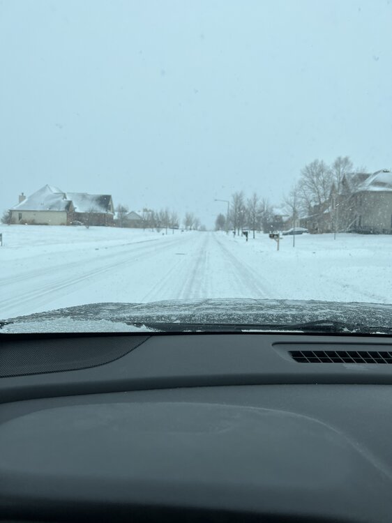
-
Jan 28-29th Baroclinic Rider
SchaumburgStormer replied to Chicago Storm's topic in Lakes/Ohio Valley
Nah. Short to mid term trends looking solid -
Jan 28-29th Baroclinic Rider
SchaumburgStormer replied to Chicago Storm's topic in Lakes/Ohio Valley
Already approaching .5” here -
Jan 28-29th Baroclinic Rider
SchaumburgStormer replied to Chicago Storm's topic in Lakes/Ohio Valley
As they develop over you, they head for me. So keep doing your cloud seeding! -
Jan 28-29th Baroclinic Rider
SchaumburgStormer replied to Chicago Storm's topic in Lakes/Ohio Valley
Just waiting for my 10+” that Izzi mentioned in the AFD. -
Jan 28-29th Baroclinic Rider
SchaumburgStormer replied to Chicago Storm's topic in Lakes/Ohio Valley
Waiting for the banding to start to come into focus is like “old school” trying to predict the pivot point. You know, back when we had storms that did that kind of shit -
Jan 28-29th Baroclinic Rider
SchaumburgStormer replied to Chicago Storm's topic in Lakes/Ohio Valley
HRRR trends over the last few runs are solid for N IL as well -
Jan 28-29th Baroclinic Rider
SchaumburgStormer replied to Chicago Storm's topic in Lakes/Ohio Valley
NAM has been playing catch-up and moving south every run since its Green Bay special yesterday. Excited for the potential, and we are basically getting to nowcast time. -
Jan 28-29th Baroclinic Rider
SchaumburgStormer replied to Chicago Storm's topic in Lakes/Ohio Valley
Well it is well south of where the northern camp had it yesterday. -
Jan 28-29th Baroclinic Rider
SchaumburgStormer replied to Chicago Storm's topic in Lakes/Ohio Valley
Subtle trend south with each run today.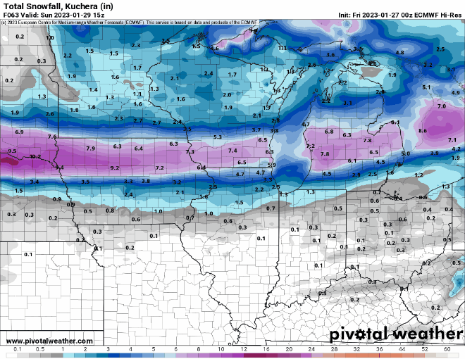
-
Jan 28-29th Baroclinic Rider
SchaumburgStormer replied to Chicago Storm's topic in Lakes/Ohio Valley
After the euro was consistent for several days right around/north of the border -
Jan 28-29th Baroclinic Rider
SchaumburgStormer replied to Chicago Storm's topic in Lakes/Ohio Valley
Yeah, everything showing this thing shearing out and the NAM wanting to pump it up. I think RC mentioned the same thing earlier as well. Looks like a blanket WWA for 3-6 across N IL and S WI -
Jan 28-29th Baroclinic Rider
SchaumburgStormer replied to Chicago Storm's topic in Lakes/Ohio Valley
Its been coming south, barely.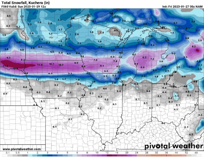
-
Jan 28-29th Baroclinic Rider
SchaumburgStormer replied to Chicago Storm's topic in Lakes/Ohio Valley
Well the 18z NAM has all of cooking county in the rain at 33hrs, remains the north outlier. Edit: Long range HRRR throwing blindfolded darts well into WI. -
Winter 2022/23 Short/Medium Range Discussion
SchaumburgStormer replied to Chicago Storm's topic in Lakes/Ohio Valley
Second squall line bringing the goods too -
Jan 28-29th Baroclinic Rider
SchaumburgStormer replied to Chicago Storm's topic in Lakes/Ohio Valley
Euro coming south too -
Winter 2022/23 Short/Medium Range Discussion
SchaumburgStormer replied to Chicago Storm's topic in Lakes/Ohio Valley
Looks like another squall line approaching 39 -
Jan 28-29th Baroclinic Rider
SchaumburgStormer replied to Chicago Storm's topic in Lakes/Ohio Valley
Well, we’ve also got old uncle Ukie on our side…
-
Winter 2022/23 Banter Hangout
SchaumburgStormer replied to Chicago Storm's topic in Lakes/Ohio Valley
-
Pound town under this little clipper
-
Winter 2022/23 Banter Hangout
SchaumburgStormer replied to Chicago Storm's topic in Lakes/Ohio Valley
You and I both know we will get our largest snow of the year in late April when we have zero desire for it. -
Jan 28-29th Baroclinic Rider
SchaumburgStormer replied to Chicago Storm's topic in Lakes/Ohio Valley
Looked to start that way, still a shitshow for LOT folks -
Jan 28-29th Baroclinic Rider
SchaumburgStormer replied to Chicago Storm's topic in Lakes/Ohio Valley
12z NAM looks to be adjusting south some. -
Jan 28-29th Baroclinic Rider
SchaumburgStormer replied to Chicago Storm's topic in Lakes/Ohio Valley
HRRR trying to make this a Green Bay special. Really an obnoxious spread amongst the models, basically going to have to nowcast this thing. I-88 and north in IL can get the storied 0-8” forecast


