
CoolHandMike
-
Posts
1,554 -
Joined
-
Last visited
Content Type
Profiles
Blogs
Forums
American Weather
Media Demo
Store
Gallery
Everything posted by CoolHandMike
-
Weird storm line coming through. Coatesville was surrounded in angry red radar returns while remaining completely calm as the storm passed. It was almost like we were under a bubble.
-
Had some moderate rain come through and now the temp's down to 73°F. Today's weather (at least IMBY) doesn't appear to be nearly as violent as yesterday or Tuesday, thankfully.
-
Same. About to get hit with all that rain near Coatesville. Luckily, I think I'm no longer in any danger of hail; unluckily, my wife is trying to get home from Exton and the 30 is guaranteed to be a parking lot.
-
Have two storms closing in near me near Coatesville. Worried about hail. Sky looks angry, lots of scud moving around under the cloud deck.
-
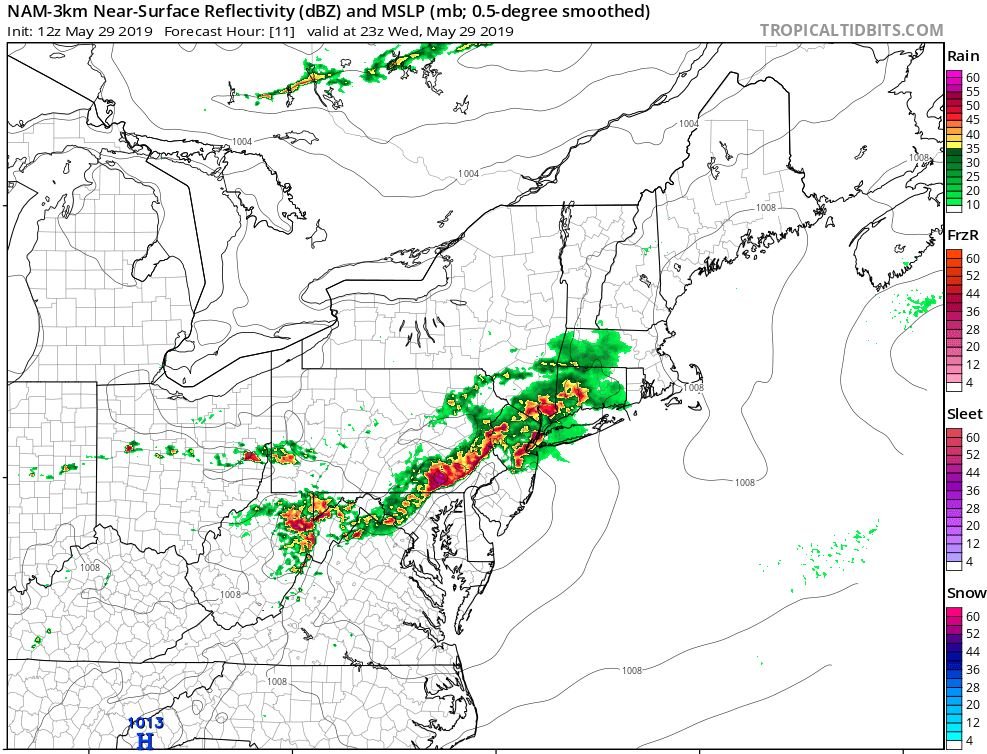
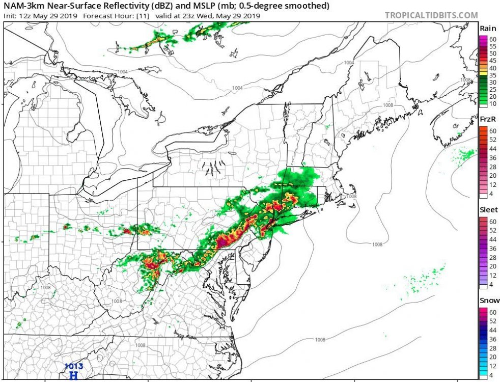
And 12Z NAM 3km looks nasty this evening * edit: whoops, didn't see that The Iceman already posted this
-
New mesoscale discussion is out: https://www.spc.noaa.gov/products/md/2019/md0881.html Mesoscale Discussion 0881 NWS Storm Prediction Center Norman OK 1106 AM CDT Wed May 29 2019 Areas affected...Portions of eastern OH...the northern WV Panhandle...much of PA...and NJ Concerning...Severe potential...Watch likely Valid 291606Z - 291730Z Probability of Watch Issuance...95 percent SUMMARY...Scattered severe thunderstorms are expected to develop this afternoon. Large hail and damaging winds should be the main threats, but isolated tornadoes will also be possible. Watch issuance is likely by 17Z (1 PM EDT). DISCUSSION...A shortwave trough over central OH and Lake Erie at 16Z will move eastward today across PA and vicinity. Isolated thunderstorms have recently initiated across central OH and northwestern PA in association with this feature. A belt of strong 50-65 kt mid-level westerly winds will be present across eastern OH, much of PA, and NJ today. Long, nearly straight hodographs through mid levels and related 40-50 kt of effective bulk shear should favor scattered splitting supercells early this afternoon. Large hail will probably be the initial concern with this convection, with some increase in the damaging wind threat with time as storms potentially congeal into one or more bowing line segments as they move east-southeastward across PA into NJ. A marine front located over the NYC metro area and adjacent northern NJ will likely limit the northeastern extent of the substantial severe threat this afternoon. In addition to the large hail and damaging wind risk, isolated tornadoes could also occur over mainly parts of central/eastern PA into portions of NJ to the east of a weak surface low where low-level southwesterly winds are forecast to be somewhat stronger. Watch issuance will likely be needed across this region by 17Z (1 PM EDT).
-
Camped out for 20 minutes in the basement. Only rain and thunder here, but man did it look wild outside right before I called a general retreat for the fam.
-
Just got a tornado warning alert on my phone, but I think it's for the storm up in Berks. Edit: I looks like it's actually for the storm just to my east, near Coatesville. Time to head to the basement...
-

March 2, 2019 Snow Event Discussion
CoolHandMike replied to Ralph Wiggum's topic in Philadelphia Region
turned out to be kind of a dud here. Mostly sleet, and it never really got below freezing at the surface. Saw very little in the way of actual snow.