donsutherland1
-
Posts
21,074 -
Joined
Content Type
Profiles
Blogs
Forums
American Weather
Media Demo
Store
Gallery
Everything posted by donsutherland1
-
Yes. It seems to be a programming issue.
-
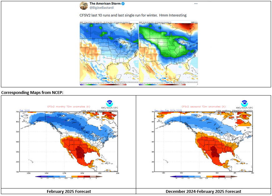
As has repeatedly been pointed out by @GaWx, WeatherBell's CFSv2 maps tend to be colder than those on other sites, including NCEP. Below is the latest example:
-
October 2024 temperature forecast contest
donsutherland1 replied to Roger Smith's topic in Weather Forecasting and Discussion
DCA _ NYC _ BOS __ ORD _ ATL _ IAH __ DEN _ PHX _ SEA 0.3 0.5 0.5 1.8 -0.2 1.0 5.0 5.5 1.5 -
Tomorrow through Wednesday will be variably cloudy with temperatures reaching the upper 60s and lower 70s. It will likely turn somewhat milder late in the week. Cooler air could arrive during the weekend. In the Southwest and parts of California, near record and record heat continued. As of 2:15 MST, Phoenix had reached 113°, which demolished the daily record of 107° from 2003. The extreme heat will persist into at least midweek. Continuing long-range guidance suggests that October could wind up warmer than normal across much of the U.S. The western U.S. could be particularly warm relative to normal. Widespread October warmth occurred during the last case where the AO fell to -2.000 or below while the PNA rose to +1.000 or above with a cool ENSO Region 3.4 anomaly in late September (2010), as was the case this year. The NAO fell to a preliminary -2.751 on September 24th (all-time September record: -2.371, September 12, 1971). That was the 9th lowest value on record. La Niña winters following September cases where the NAO fell to -1.900 or below featured a predominantly positive NAO. The most recent such winters were 2016-2017 and 2022-2023. The mean temperatures for those winters in New York City were 39.3° and 41.0° respectively. The 1991-2020 normal value is 36.2°. A warmer outcome is favored by the September run of the C3S multi-model forecast for Winter 2024-2025. The ENSO Region 1+2 anomaly was +0.2°C and the Region 3.4 anomaly was -0.5°C for the week centered around September 18. For the past six weeks, the ENSO Region 1+2 anomaly has averaged -0.20°C and the ENSO Region 3.4 anomaly has averaged -0.18°C. Neutral ENSO conditions will likely evolve into a La Niña event during the fall. The SOI was +2.26 today. The preliminary Arctic Oscillation (AO) was +0.282 today. Based on sensitivity analysis applied to the latest guidance, there is an implied 95% probability that New York City will have a cooler than normal September (1991-2020 normal). September will likely finish with a mean temperature near 68.9° (0.3° below normal).
- 1,154 replies
-
- 1
-

-
- tropics
- heavy rainfall
- (and 3 more)
-
2024 Atlantic Hurricane Season
donsutherland1 replied to Stormchaserchuck1's topic in Tropical Headquarters
I am truly sorry to read this. I hope that he will be found ok. -
Occasional Thoughts on Climate Change
donsutherland1 replied to donsutherland1's topic in Climate Change
Yes, the warming atmosphere is holding more water vapor. I believe Ben Noll posted that the atmosphere ahead of Helene had record PWAT values, which isn't surprising given the ongoing marine heatwave in the Gulf of Mexico. It was interesting to see that the recent study on TC precipitation amounts found that they exceed what might be expected from the CC equation. Then again, daily and monthly heat extremes are increasing above the rate of overall warming. Research regarding TCs continues. It will be fascinating to see what is published in the years ahead. -
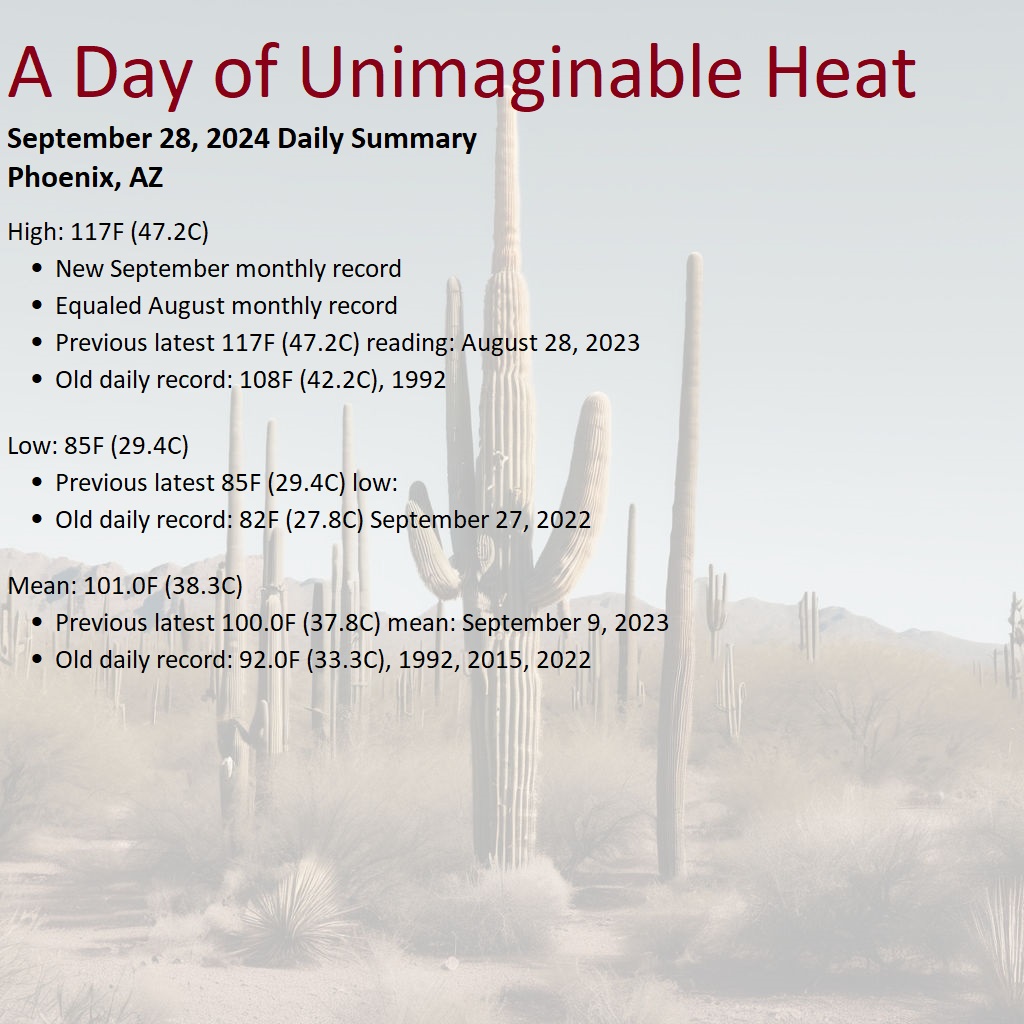
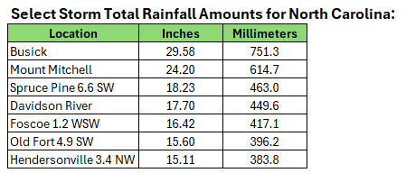
Tomorrow will be variably cloudy with temperatures reaching the upper 60s and lower 70s. A shower is possible. A similar temperature regime will start the work week, but it could turn somewhat milder late in the week. So far, the highest storm total rainfall from Helene in North Carolina is 36.54" at Jonas Ridge. If validated, that would be a new state record. In the Southwest and parts of California, near record and record heat continued. Today saw the heat peak. Phoenix topped out at 117°, which toppled the all-time September monthly record and matched the existing August mark. The previous latest-season 117° temperature occurred on August 28, 2023. The extreme heat will persist into at least the middle of next week. Continuing long-range guidance suggests that October could wind up warmer than normal across much of the U.S. The western U.S. could be particularly warm relative to normal. Widespread October warmth occurred during the last case where the AO fell to -2.000 or below while the PNA rose to +1.000 or above with a cool ENSO Region 3.4 anomaly in late September (2010), as was the case this year. The NAO fell to a preliminary -2.751 on September 24th (all-time September record: -2.371, September 12, 1971). That was the 9th lowest value on record. La Niña winters following September cases where the NAO fell to -1.900 or below featured a predominantly positive NAO. The most recent such winters were 2016-2017 and 2022-2023. The mean temperatures for those winters in New York City were 39.3° and 41.0° respectively. The 1991-2020 normal value is 36.2°. A warmer outcome is favored by the September run of the C3S multi-model forecast for Winter 2024-2025. The ENSO Region 1+2 anomaly was +0.2°C and the Region 3.4 anomaly was -0.5°C for the week centered around September 18. For the past six weeks, the ENSO Region 1+2 anomaly has averaged -0.20°C and the ENSO Region 3.4 anomaly has averaged -0.18°C. Neutral ENSO conditions will likely evolve into a La Niña event during the fall. The SOI was +4.99 today. The preliminary Arctic Oscillation (AO) was +0.384 today. Based on sensitivity analysis applied to the latest guidance, there is an implied 67% probability that New York City will have a cooler than normal September (1991-2020 normal). September will likely finish with a mean temperature near 69.0° (0.2° below normal).
-
Phoenix set a new all-time September monthly record high temperature today. The high was 117F, which matched the August monthly record.

-
Occasional Thoughts on Climate Change
donsutherland1 replied to donsutherland1's topic in Climate Change
Climate change deniers are frantically trying to deflect attention from the climate change link to Hurricane Helene. The link was highlighted in, among other places, a post by German climate scientist Stefan Rahmstorf and a CNN interview with U.S. climate scientist Michael Mann. In fact, the latest literature links tropical cyclone rapid intensification to climate change. One paper (Bhatia et al., 2022) declares, "In multiple basins and the global dataset, we detect a significant increase in intensification rates with a positive contribution from anthropogenic forcing." Climate change is also leading to increased precipitation from tropical cyclones. One recent paper (Shi et al., 2024) noted that precipitation could increase over city-sized areas by about 18% for every 1°C warming due to complex processes. Attribution studies have also confirmed the findings of the literature. Examples include: Hurricane Harvey (2017) Typhoon Gaemi (2024) The noisy effort by climate change deniers to exploit Helene for disinformation purposes should be ignored. First, they have never published any research on tropical cyclones and climate change. Second, a number of them have been fact checked by AFP for posting misleading or inaccurate information (some multiple times). The literature and attribution studies tell the actual story. Climate change is impacting tropical cyclone precipitation and rapid intensification. -
It will turn slightly cooler for the weekend with highs mainly in the upper 60s and Lower 70s. Helene has brought historic rains to the Asheville area. Its 2-day total exceeded the highest amount recorded over 5 days and its 3-day total exceeded its highest 15-day figure prior to 2024. Atlanta picked up 3" or more rain on three consecutive days, which broke the record set during December 8-9, 1919 and tied during July 4-5, 1994. In the Southwest and parts of California, near record and record heat continues. The extreme heat will last through the coming weekend. Phoenix and Tucson will experience their highest temperatures so late in the season. Continuing long-range guidance suggests that October could wind up warmer than normal across much of the U.S. The western U.S. could be particularly warm relative to normal. Widespread October warmth occurred during the last case where the AO fell to -2.000 or below while the PNA rose to +1.000 or above with a cool ENSO Region 3.4 anomaly in late September (2010), as was the case this year. The NAO fell to a preliminary -2.751 on September 24th (all-time September record: -2.371, September 12, 1971). That was the 9th lowest value on record. La Niña winters following September cases where the NAO fell to -1.900 or below featured a predominantly positive NAO. The most recent such winters were 2016-2017 and 2022-2023. The mean temperatures for those winters in New York City were 39.3° and 41.0° respectively. The 1991-2020 normal value is 36.2°. A warmer outcome is favored by the September run of the C3S multi-model forecast for Winter 2024-2025. The ENSO Region 1+2 anomaly was +0.2°C and the Region 3.4 anomaly was -0.5°C for the week centered around September 18. For the past six weeks, the ENSO Region 1+2 anomaly has averaged -0.20°C and the ENSO Region 3.4 anomaly has averaged -0.18°C. Neutral ENSO conditions will likely evolve into a La Niña event during the fall. The SOI was +6.42 today. The preliminary Arctic Oscillation (AO) was -0.304 today. Based on sensitivity analysis applied to the latest guidance, there is an implied 57% probability that New York City will have a cooler than normal September (1991-2020 normal). September will likely finish with a mean temperature near 69.1° (0.1° below normal).
-
-
Helen continues to bring prolific rainfall. As of 7:25 am, Atlanta has 3.22" of rain today. Today is the third consecutive day with 3" or more rain. That breaks the record of 2 days set during December 8-9, 1919 and tied during July 4-5, 1994. The three-day total rainfall is 10.96".
-
Yes, that's at the Airport. I saw the 12.29" figure for Conesstee Falls as of late this morning.
-
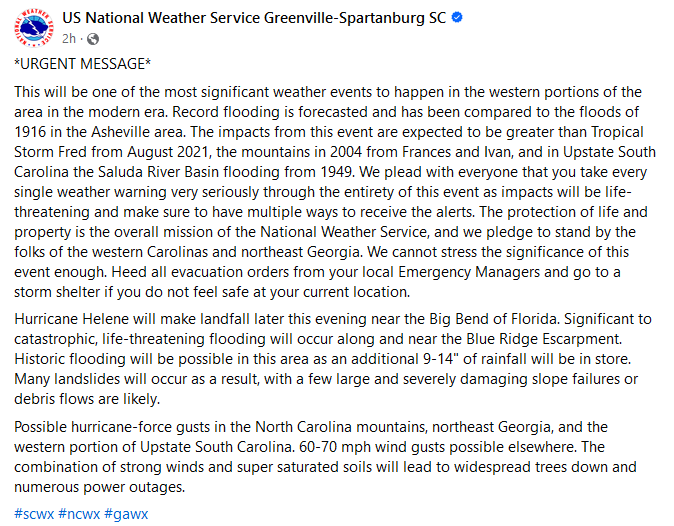
Temperatures will reach the lower and even middle 70s across the region tomorrow. It will turn slightly cooler for the weekend with highs mainly in the upper 60s and Lower 70s. In the Southwest and parts of California, near record and record heat is underway. The extreme heat will last through the coming weekend. Phoenix and Tucson will experience their highest temperatures so late in the season. Hurricane Helene will make landfall in Florida's Big Bend region tonight as a Category 4 hurricane with a devastating storm surge. Extreme rainfall could spread as far north as the southern Appalachians. Flooding rains will also affect such cities as Atlanta, Columbus, Macon, and Tallahassee. Already, as of 6:45 pm EDT, Asheville, NC has seen 4.72" of rain today. That is the highest daily amount on record for September. Its two-day total of 8.81" exceeds its prior 2-day, 3-day, and 4-day records. Helene's rainfall is unlikely to reach the New York City area. Continuing long-range guidance suggests that October could wind up warmer than normal across much of the U.S. The western U.S. could be particularly warm relative to normal. Widespread October warmth occurred during the last case where the AO fell to -2.000 or below while the PNA rose to +1.000 or above with a cool ENSO Region 3.4 anomaly in late September (2010), as was the case this year. The NAO fell to a preliminary -2.751 on September 24th (all-time September record: -2.371, September 12, 1971). That was the 9th lowest value on record. La Niña winters following September cases where the NAO fell to -1.900 or below featured a predominantly positive NAO. The most recent such winters were 2016-2017 and 2022-2023. The mean temperatures for those winters in New York City were 39.3° and 41.0° respectively. The 1991-2020 normal value is 36.2°. A warmer outcome is favored by the September run of the C3S multi-model forecast for Winter 2024-2025. The ENSO Region 1+2 anomaly was +0.2°C and the Region 3.4 anomaly was -0.5°C for the week centered around September 18. For the past six weeks, the ENSO Region 1+2 anomaly has averaged -0.20°C and the ENSO Region 3.4 anomaly has averaged -0.18°C. Neutral ENSO conditions will likely evolve into a La Niña event during the fall. The SOI was -2.49 today. The preliminary Arctic Oscillation (AO) was -1.207 today. Based on sensitivity analysis applied to the latest guidance, there is an implied 58% probability that New York City will have a cooler than normal September (1991-2020 normal). September will likely finish with a mean temperature near 69.1° (0.1° below normal).
-
From the NWS Greeville-Spartanburg Facebook Page: Already, as of 4:07 pm EDT, Asheville has picked up 4.44" of rain today. That breaks the daily mark of 1.71" from 1956 and the all-time September daily record of 4.40" from September 29, 1964. The 2-day total of 8.53" breaks both the 2- and 3-day rainfall records.
-
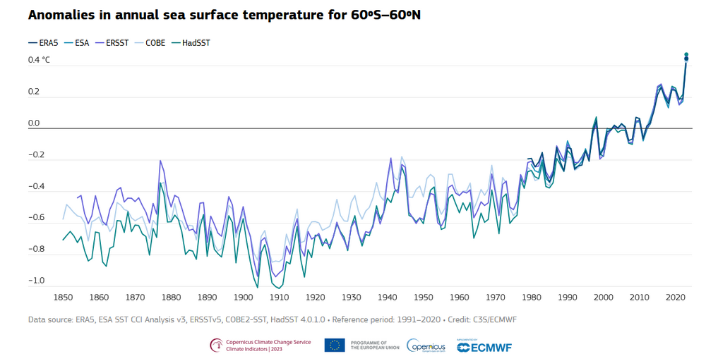
The initial reference was to the "modern period." Most datasets treat 1850-1900 as preindustrial for purposes of climate assessments. The chart only addresses that reference.
-
Technical details can be found here: https://agupubs.onlinelibrary.wiley.com/doi/full/10.1029/2018JD029867
-
Yes. That shows up well on the larger timeframe (1850-2023) available at Copernicus:
-
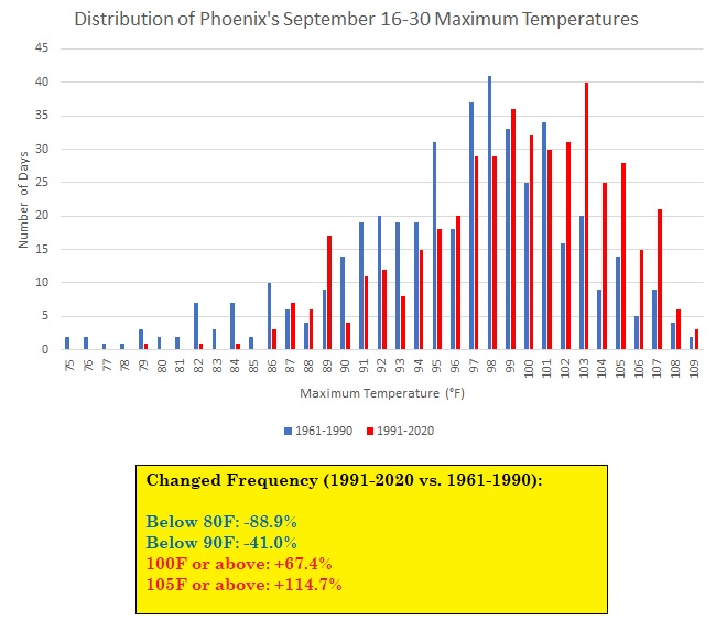
Phoenix is in the early stages of an unprecedented last week of September heatwave. This heatwave occurs as Phoenix is experiencing a warming climate. The second half of September has been warming rapidly (4.4F/2.4C from 1961-1990 to 1991-2020). The distribution of 100F (37.8C) and 105F (40.6C) or above readings has risen.
-
A generally pleasant temperature regime will continue through most or all of the week. it will turn warmer tomorrow. Showers are possible tomorrow, as well. In the Southwest and parts of California, near record and record heat is underway. Phoenix reached 113°, which smashed its daily mark of 108° from 1979 and 1989. It was also that city's latest 113° or above temperature on record by 15 days. The extreme heat will last through the coming weekend. Phoenix and Tucson will experience their highest temperatures so late in the season. Hurricane Helene will make landfall in Florida's Big Bend region tomorrow evening as a major hurricane. Extreme rainfall could spread as far north as the southern Appalachians. Flooding rains will also affect such cities as Atlanta, Columbus, Macon, and Tallahassee. Helene's rainfall is unlikely to reach the New York City area. Continuing long-range guidance suggests that October could wind up warmer than normal across much of the U.S. The western U.S. could be particularly warm relative to normal. Widespread October warmth occurred during the last case where the AO fell to -2.000 or below while the PNA rose to +1.000 or above with a cool ENSO Region 3.4 anomaly in late September (2010), as was the case this year. The NAO fell to a preliminary -2.751 on September 24th (all-time September record: -2.371, September 12, 1971). That was the 9th lowest value on record. La Niña winters following September cases where the NAO fell to -1.900 or below featured a predominantly positive NAO. The most recent such winters were 2016-2017 and 2022-2023. The mean temperatures for those winters in New York City were 39.3° and 41.0° respectively. The 1991-2020 normal value is 36.2°. A warmer outcome is favored by the September run of the C3S multi-model forecast for Winter 2024-2025. The ENSO Region 1+2 anomaly was +0.2°C and the Region 3.4 anomaly was -0.5°C for the week centered around September 18. For the past six weeks, the ENSO Region 1+2 anomaly has averaged -0.20°C and the ENSO Region 3.4 anomaly has averaged -0.18°C. Neutral ENSO conditions will likely evolve into a La Niña event during the fall. The SOI was -4.87 today. The preliminary Arctic Oscillation (AO) was -1.207 today. Based on sensitivity analysis applied to the latest guidance, there is an implied 52% probability that New York City will have a cooler than normal September (1991-2020 normal). September will likely finish with a mean temperature near 69.1° (0.1° below normal).
- 1,154 replies
-
- 1
-
-
- tropics
- heavy rainfall
- (and 3 more)
-
La Niña is on the cusp of developing. Region 3.4 anomalies have fallen to -0.5°C in the most recent weekly average. A weak La Niña and potentially borderline moderate one still seems on course during the latter part of the fall and during the winter.
-
A generally pleasant temperature regime will continue through most or all of the week. Temperatures could top out in the upper 60s to lower 70s through the middle of the week before a slow warming trend commences afterward. Showers are possible on tomorrow and Thursday. Rainfall amounts should average 0.25"-0.50" in the New York City and Philadelphia Metro areas with some locally higher amounts. In the Southwest and parts of California, another round of excessive heat is now underway. Parts of the region will likely see near record to record high temperatures on several days during the week and weekend. Phoenix could see its highest temperatures so late in the season. In addition, a significant hurricane will likely make northwestern Florida landfall on Thursday. The storm will likely be a major hurricane on landfall given the ongoing marine heatwave in the region and relatively low shear. However, the hurricane's rainfall is unlikely to reach the New York City area. Continuing long-range guidance suggests that October could wind up warmer than normal across much of the U.S. Widespread October warmth occurred during the last case where the AO fell to -2.000 or below while the PNA rose to +1.000 or above with a cool ENSO Region 3.4 anomaly (2010), as was the case with the September 20th teleconnections. The NAO fell to a preliminary -2.751 today (all-time September record: -2.371, September 12, 1971). That would be the 9th lowest value on record. La Niña winters following September cases where the NAO fell to -1.900 or below featured a predominantly positive NAO. The most recent such winters were 2016-2017 and 2022-2023. The mean temperatures for those winters in New York City were 39.3° and 41.0° respectively. The 1991-2020 normal value is 36.2°. A warmer outcome is favored by the September run of the C3S multi-model forecast for Winter 2024-2025. The ENSO Region 1+2 anomaly was +0.2°C and the Region 3.4 anomaly was -0.5°C for the week centered around September 18. For the past six weeks, the ENSO Region 1+2 anomaly has averaged -0.20°C and the ENSO Region 3.4 anomaly has averaged -0.18°C. Neutral ENSO conditions will likely evolve into a La Niña event during the fall. The SOI was -8.08 today. The preliminary Arctic Oscillation (AO) was -1.501 today. Based on sensitivity analysis applied to the latest guidance, there is an implied 57% probability that New York City will have a cooler than normal September (1991-2020 normal). September will likely finish with a mean temperature near 69.0° (0.2° below normal).
-
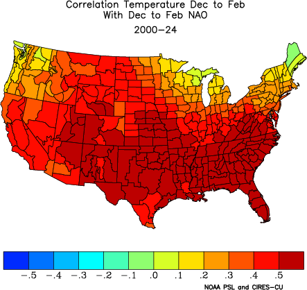
Yes. Temperature correlation (2000-present):
-
I suspect that the low sea ice and resulting warming of the open waters is contributing to this increased volatility.
-
During La Niña winters, this would suggest a predominantly NAO+ winter. During El Niño winters, including 2002-03, it would suggest a predominantly NAO- winter. Still, the sample sizes are small, so such tendencies should be taken with a large dose of caution.