

donsutherland1
-
Posts
24,194 -
Joined
Content Type
Profiles
Blogs
Forums
American Weather
Media Demo
Store
Gallery
Everything posted by donsutherland1
-
Morning thoughts… Warmer air will begin to move into the region. It will be partly sunny and milder today. High temperatures will likely reach the upper 50s and lower 60s in much of the region. Likely high temperatures around the region include: New York City (Central Park): 57° Newark: 59° Philadelphia: 63° Much of the week will see above to much above normal temperatures. Back door cold fronts could briefly interrupt the warmth in some areas. Normals: New York City: 30-Year: 60.1°; 15-Year: 60.4° Newark: 30-Year: 60.9°; 15-Year: 61.3° Philadelphia: 30-Year: 63.0°; 15-Year: 63.6
-
Noticeably warmer air will begin to move into the region starting tomorrow. Tuesday through Friday will generally be warmer to much warmer than normal. There could be brief interruptions of the warmth from backdoor cold fronts. The Northern Plains could witness the development of a major spring snowstorm or blizzard tomorrow night or Tuesday. Parts of North Dakota could see 1-2 feet of snow with drifts in excess of 4 feet. The ENSO Region 1+2 anomaly was -1.0°C and the Region 3.4 anomaly was -0.7°C for the week centered around March 30. For the past six weeks, the ENSO Region 1+2 anomaly has averaged -0.80°C and the ENSO Region 3.4 anomaly has averaged -0.90°C. La Niña conditions will likely persist into at least mid-April. The SOI was +21.41 today. Today was the 6th consecutive day that the SOI was +20.00 or above. The last time that happened was January 13-19, 2021 when the SOI reached +20.00 or above on 7 consecutive days. The last time that happened in April was March 28-April 5, 2011 when the SOI reached at least +20.00 on 9 consecutive days. Then, there was a brief period of much warmer than normal temperatures following the end of that stretch and a longer period of much warmer than normal temperatures starting about 2 1/2 weeks later. The preliminary Arctic Oscillation (AO) was -0.977 today. On April 8 the MJO was in Phase 5 at an amplitude of 0.355 (RMM). The April 7-adjusted amplitude was 0.423 (RMM). Based on sensitivity analysis applied to the latest guidance, there is an implied 54% probability that New York City will have a warmer than normal April (1991-2020 normal). April will likely finish with a mean temperature near 54.0° (0.3° above normal).
-
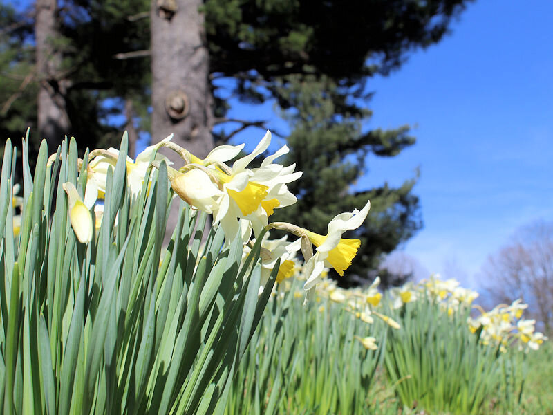
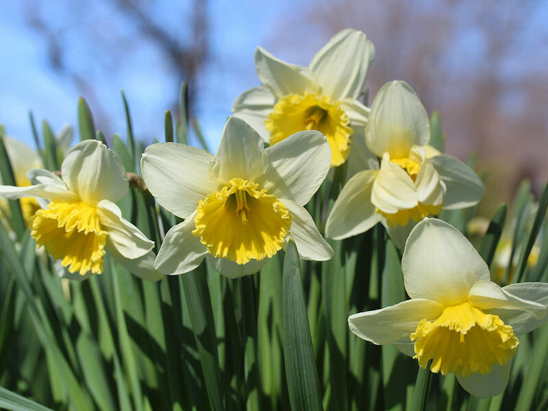
It is quite springlike here in terms of flowers. Some were damaged by the late March cold.
-
Despite considerable clouds, sprinkles, and a temperature in the upper 40s, spring scenes are widespread throughout the New York Botanical Garden.


-
Morning thoughts… It will be partly sunny and cool today. High temperatures will likely reach the lower 50s in much of the region. Likely high temperatures around the region include: New York City (Central Park): 52° Newark: 53° Philadelphia: 53° It will turn warmer starting tomorrow and much of the week will see above to much above normal temperatures. Back door cold fronts could briefly interrupt the warmth in some areas. Normals: New York City: 30-Year: 59.6°; 15-Year: 60.0° Newark: 30-Year: 60.9°; 15-Year: 61.3° Philadelphia: 30-Year: 62.6°; 15-Year: 63.2°
-
Tomorrow will be partly to mostly sunny and cooler. Noticeably warmer air will likely move into the region early next week. The warmth will likely continue through much of the week before cooler air returns. There could be brief interruptions of the warmth from backdoor cold fronts. The ENSO Region 1+2 anomaly was -1.0°C and the Region 3.4 anomaly was -0.7°C for the week centered around March 30. For the past six weeks, the ENSO Region 1+2 anomaly has averaged -0.80°C and the ENSO Region 3.4 anomaly has averaged -0.90°C. La Niña conditions will likely persist into at least mid-April. The SOI was +24.30 today. The preliminary Arctic Oscillation (AO) was -0.208 today. On April 7 the MJO was in Phase 3 at an amplitude of 0.420 (RMM). The April 6-adjusted amplitude was 0.520 (RMM). Based on sensitivity analysis applied to the latest guidance, there is an implied 52% probability that New York City will have a warmer than normal April (1991-2020 normal). April will likely finish with a mean temperature near 53.9° (0.2° above normal).
-
Morning thoughts… It will be variably cloudy with some showers. High temperatures will likely reach the middle and upper 50s in much of the region. Likely high temperatures around the region include: New York City (Central Park): 57° Newark: 58° Philadelphia: 59° Temperatures will be near or somewhat below normal through the weekend. Normals: New York City: 30-Year: 59.2°; 15-Year: 59.6° Newark: 30-Year: 60.0°; 15-Year: 60.5° Philadelphia: 30-Year: 62.2°; 15-Year: 62.8°
-
Rain will return tomorrow. Showers and periods of rain are likely. Readings will be confined to the 50s tomorrow and Sunday, even Sunday is partly to mostly sunny. Noticeably warmer air will likely move into the region early next week. The warmth will likely continue through much of the week before cooler air returns. The ENSO Region 1+2 anomaly was -1.0°C and the Region 3.4 anomaly was -0.7°C for the week centered around March 30. For the past six weeks, the ENSO Region 1+2 anomaly has averaged -0.80°C and the ENSO Region 3.4 anomaly has averaged -0.90°C. La Niña conditions will likely persist into at least mid-April. The SOI was +22.13 today. The preliminary Arctic Oscillation (AO) was -0.038 today. On April 5 the MJO was in Phase 3 at an amplitude of 0.516 (RMM). The April 4-adjusted amplitude was 0.530 (RMM). Based on sensitivity analysis applied to the latest guidance, there is an implied 51% probability that New York City will have a warmer than normal April (1991-2020 normal). April will likely finish with a mean temperature near 53.9° (0.2° above normal).
-
Morning thoughts… It will be partly sunny and milder. High temperatures will likely reach the lower and middle 60s in much of the region. Likely high temperatures around the region include: New York City (Central Park): 61° Newark: 63° Philadelphia: 64° Temperatures will be near or somewhat below normal through the weekend. Normals: New York City: 30-Year: 58.8°; 15-Year: 59.2° Newark: 30-Year: 59.6°; 15-Year: 60.1° Philadelphia: 30-Year: 61.8°; 15-Year: 62.4°
-
Morning thoughts… Rain will develop and it could fall moderately to perhaps heavily this afternoon and evening. High temperatures will likely reach the lower and middle 50s in much of the region. Likely high temperatures around the region include: New York City (Central Park): 52° Newark: 53° Philadelphia: 56° Temperatures will be near or somewhat below normal into the weekend. Normals: New York City: 30-Year: 58.3°; 15-Year: 58.7° Newark: 30-Year: 59.1°; 15-Year: 59.7° Philadelphia: 30-Year: 61.3°; 15-Year: 61.9°
-
Drizzle is likely overnight before additional steady rain arrives tomorrow. The rain could fall moderately to heavily at times tomorrow afternoon. A shower or two is possible on Friday. Overall, the week will see mainly near to somewhat below normal temperatures. There are growing hints on the guidance that noticeably warmer air could move into the region next week for several days. It is likely that New York City's Central Park has seen its last freeze of the season. Overall, April could wind up near to somewhat warmer normal overall in the northern Mid-Atlantic region. The ENSO Region 1+2 anomaly was -1.0°C and the Region 3.4 anomaly was -0.7°C for the week centered around March 30. For the past six weeks, the ENSO Region 1+2 anomaly has averaged -0.80°C and the ENSO Region 3.4 anomaly has averaged -0.90°C. La Niña conditions will likely persist into at least mid-April. The SOI was +31.80 today. The preliminary Arctic Oscillation (AO) was +0.640 today. On April 4 the MJO was in Phase 2 at an amplitude of 0.343 (RMM). The April 3-adjusted amplitude was 0.356 (RMM).
-
Morning thoughts… It will be mostly cloudy with rain. Most of the rain will fall during the morning hours. High temperatures will likely reach the lower and middle 50s in much of the region. Likely high temperatures around the region include: New York City (Central Park): 53° Newark: 55° Philadelphia: 59° Temperatures will be near or somewhat below normal into the weekend. Normals: New York City: 30-Year: 57.9°; 15-Year: 58.3° Newark: 30-Year: 58.7°; 15-Year: 59.3° Philadelphia: 30-Year: 60.9°; 15-Year: 61.5°
-
Rain and showers will continue overnight. Some of the rain tomorrow morning could be heavy. Overall, rain and showers and could linger through at least Thursday even as there will likely be a break tomorrow. Overall, the week will see mainly near to somewhat below normal temperatures. There are growing hints on the guidance that noticeably warmer air could move into the region next week for several days. It is likely that New York City's Central Park has seen its last freeze of the season. Overall, April could wind up near to somewhat warmer normal overall in the northern Mid-Atlantic region. The ENSO Region 1+2 anomaly was -1.0°C and the Region 3.4 anomaly was -0.7°C for the week centered around March 30. For the past six weeks, the ENSO Region 1+2 anomaly has averaged -0.80°C and the ENSO Region 3.4 anomaly has averaged -0.90°C. La Niña conditions will likely persist into at least mid-April. The SOI was +25.96 today. The preliminary Arctic Oscillation (AO) was +0.690 today. On April 3 the MJO was in Phase 1 at an amplitude of 0.372 (RMM). The April 2-adjusted amplitude was 0.331 (RMM).
-
Morning thoughts… It will be mostly cloudy. Rain will arrive late in the day. High temperatures will likely reach the middle 50s in much of the region. Likely high temperatures around the region include: New York City (Central Park): 54° Newark: 54° Philadelphia: 57° Temperatures will be near or somewhat below normal into the weekend. Normals: New York City: 30-Year: 57.5°; 15-Year: 57.9° Newark: 30-Year: 58.3°; 15-Year: 58.9° Philadelphia: 30-Year: 60.5°; 15-Year: 61.1°
-
Rain and showers will return late tomorrow and could linger through at least Thursday. Overall, the week will see mainly near normal temperatures. Late in the second week of the month, there are some hints on the guidance that noticeably warmer air could try to move into the region. It is possible that New York City's Central Park has seen its last freeze of the season. Overall, April could wind up near to somewhat warmer normal overall in the northern Mid-Atlantic region. The ENSO Region 1+2 anomaly was -1.0°C and the Region 3.4 anomaly was -0.7°C for the week centered around March 30. For the past six weeks, the ENSO Region 1+2 anomaly has averaged -0.80°C and the ENSO Region 3.4 anomaly has averaged -0.90°C. La Niña conditions will likely persist into at least mid-April. The SOI was +14.85 today. The preliminary Arctic Oscillation (AO) was +0.360 today. On April 2 the MJO was in Phase 1 at an amplitude of 0.496 (RMM). The April 1-adjusted amplitude was 0.667 (RMM).
-
Morning thoughts… It will be partly sunny with readings near or just below seasonable levels. High temperatures will likely reach the middle 50s in much of the region. Likely high temperatures around the region include: New York City (Central Park): 55° Newark: 56° Philadelphia: 57° Temperatures will be near or somewhat below normal through midweek. Normals: New York City: 30-Year: 57.0°; 15-Year: 57.5° Newark: 30-Year: 57.9°; 15-Year: 58.5° Philadelphia: 30-Year: 60.1°; 15-Year: 60.7°
-
It was covered. This reality may not have reached a sufficiently broad audience: https://news.un.org/en/story/2022/03/1114272
-
Dry conditions with near normal temperatures will return on tomorrow. However, the dry conditions will be short-lived. Rain and showers will return Tuesday and could linger through at least Thursday. Overall, the week will see mainly near normal temperatures. Late in the second week of the month, there are some hints on the guidance that noticeably warmer air could try to move into the region. It is possible that New York City's Central Park has seen its last freeze of the season. Overall, April could wind up near to somewhat warmer normal overall in the northern Mid-Atlantic region. The ENSO Region 1+2 anomaly was -0.5°C and the Region 3.4 anomaly was -0.9°C for the week centered around March 23. For the past six weeks, the ENSO Region 1+2 anomaly has averaged -0.92°C and the ENSO Region 3.4 anomaly has averaged -0.88°C. La Niña conditions will likely persist into at least mid-April. The SOI was +4.25 today. The preliminary Arctic Oscillation (AO) was -0.457 today. On April 1 the MJO was in Phase 1 at an amplitude of 0.686 (RMM). The March 31-adjusted amplitude was 0.772 (RMM).
-
Morning thoughts… It will become partly to mostly cloudy with some showers and periods of light rain. Parts of northwest New Jersey and adjacent Pennsylvania and New York State could see some early snow. High temperatures will likely reach the lower and middle 50s in much of the region. Likely high temperatures around the region include: New York City (Central Park): 52° Newark: 52° Philadelphia: 58° Temperatures will be near or somewhat below normal through midweek. Normals: New York City: 30-Year: 56.6°; 15-Year: 57.5° Newark: 30-Year: 57.4°; 15-Year: 58.1° Philadelphia: 30-Year: 59.7°; 15-Year: 60.3°
-
Tomorrow will be mostly cloudy with showers and periods of rain. It will be somewhat cooler than normal. Dry conditions with near normal temperatures will return on Monday. Nevertheless, it is possible that New York City's Central Park has seen its last freeze of the season. Overall, April could wind up near to somewhat warmer normal overall in the northern Mid-Atlantic region. The ENSO Region 1+2 anomaly was -0.5°C and the Region 3.4 anomaly was -0.9°C for the week centered around March 23. For the past six weeks, the ENSO Region 1+2 anomaly has averaged -0.92°C and the ENSO Region 3.4 anomaly has averaged -0.88°C. La Niña conditions will likely persist into at least mid-April. The SOI was -3.39 today. The SOI fell 20.48 points over the past day. The last time that happened was October 22-23, 2021 when the SOI fell 28.43 points. The last time the SOI fell by 20 or more points in a 24-hour span in April was April 13-14, 2018. El Niño conditions developed the following winter. It's premature to make any ENSO forecasts for next winter given that we're in spring and such forecasts from this far out lack skill. The preliminary Arctic Oscillation (AO) was -0.928 today. On March 31 the MJO was in Phase 1 at an amplitude of 0.779 (RMM). The March 30-adjusted amplitude was 0.647 (RMM).
-
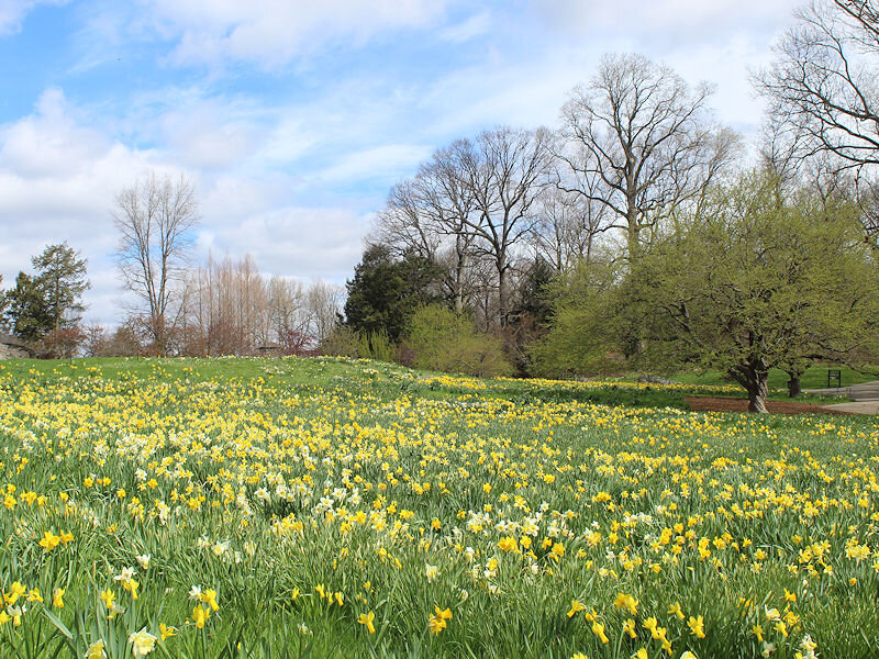
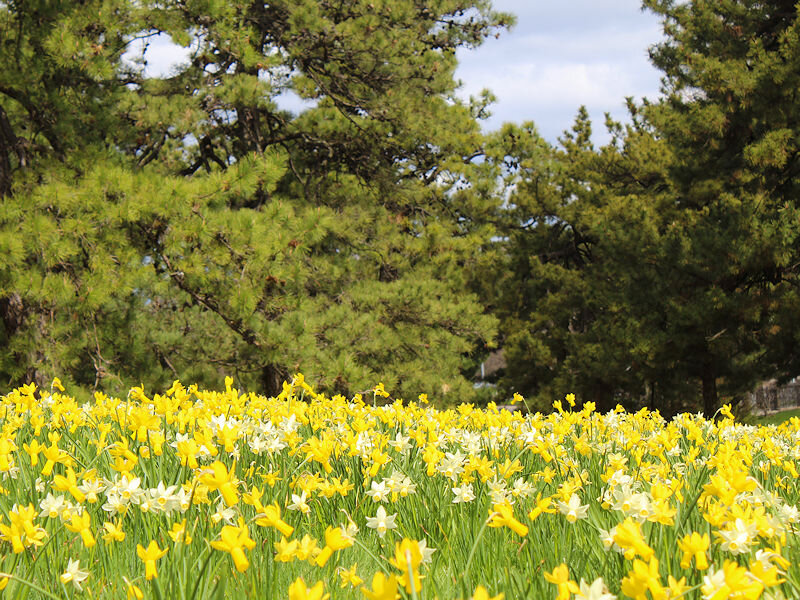
Temperatures rose into the 50s at the New York Botanical Garden where daffodils are blooming in increasing numbers.

-
Morning thoughts… It will become partly sunny and somewhat cooler than normal. High temperatures will likely reach the lower and middle 50s in much of the region. Likely high temperatures around the region include: New York City (Central Park): 54° Newark: 55° Philadelphia: 55° Showers and periods of rain are likely tomorrow. Normals: New York City: 30-Year: 56.2°; 15-Year: 57.1° Newark: 30-Year: 57.0°; 15-Year: 57.7° Philadelphia: 30-Year: 59.2°; 15-Year: 59.9°
-
It will be partly sunny and cooler tomorrow. Sunday will be mostly cloudy with showers and periods of rain. It will be somewhat cooler than normal. Nevertheless, it is possible that New York City's Central Park has seen its last freeze of the season. Overall, April could wind up near to somewhat warmer normal overall in the northern Mid-Atlantic region. The ENSO Region 1+2 anomaly was -0.5°C and the Region 3.4 anomaly was -0.9°C for the week centered around March 23. For the past six weeks, the ENSO Region 1+2 anomaly has averaged -0.92°C and the ENSO Region 3.4 anomaly has averaged -0.88°C. La Niña conditions will likely persist into at least mid-April. The SOI was +17.09 today. The preliminary Arctic Oscillation (AO) was -1.325 today. On March 30 the MJO was in Phase 8 at an amplitude of 0.650 (RMM). The March 29-adjusted amplitude was 0.665 (RMM).
-
We’ve already seen some early hints of drought-heat feedback in the Southwest. More heat—possibly record-challenging heat—could develop there next week.
-
Morning thoughts... Clouds and light rain will slowly yield to clearing. Temperatures will likely reach the middle and upper 50s in most of the region. Likely high temperatures include: New York City (Central Park): 58° Newark: 58° Philadelphia: 59° A cooler weekend lies ahead. Normals: New York City: 30-Year: 55.8°; 15-Year: 56.3° Newark: 30-Year: 56.6°; 15-Year: 57.4° Philadelphia: 30-Year: 58.8°; 15-Year: 59.5° 30-Day Verification: New York City (Central Park): Average daily forecast: 52.9° Average temperature: 53.3° Average error: 1.9° Newark: Average daily forecast: 54.2° Average temperature: 54.3° Average error: 1.8° Philadelphia: Average daily forecast: 57.5° Average temperature: 57.1° Average error: 1.8°

