donsutherland1
-
Posts
24,194 -
Joined
Content Type
Profiles
Blogs
Forums
American Weather
Media Demo
Store
Gallery
Everything posted by donsutherland1
-
In the wake of the passage of a strong backdoor cold front, temperatures in the northern Middle Atlantic region were around 20°-30° cooler than yesterday's highs. The heat continued from Philadelphia and southward. Following overnight showers and thundershowers, tomorrow will be warmer again with readings returning to the upper 70s and at least lower 80s in much of the northern Middle Atlantic region. However, a cold front will trigger thunderstorms, some of which can be strong. Afterward, a period of more seasonable temperatures will follow. During the closing week of May, the MJO moved through Phase 6 with an amplitude as high as 1.909. The only case with an MJO passage through Phase 6 with an amplitude of 1.500 or above during that timeframe was 1998. In 1998, the second half of June was noticeably warmer than the first half. The MJO's ongoing progression and the state of Atlantic blocking could impact the outcome for the second half of June. The ECMWF seasonal forecast indicates that the summer will be warmer than normal throughout the region and across much of North America. Based on how the pattern has been evolving during the spring transition to summer, it is more likely than not that the warmest anomalies of the summer will likely occur in July and August with June being the coolest of the three months in the Northeast. The ENSO Region 1+2 anomaly was -1.1°C and the Region 3.4 anomaly was -1.0°C for the week centered around May 25. For the past six weeks, the ENSO Region 1+2 anomaly has averaged -1.55°C and the ENSO Region 3.4 anomaly has averaged -1.08°C. La Niña conditions will likely persist through the summer. The SOI was -4.64 today. The preliminary Arctic Oscillation (AO) was -2.641 today. That breaks the previous record low of -1.956 from 1975. On May 30 the MJO was in Phase 7 at an amplitude of 2.035 (RMM). The May 29-adjusted amplitude was 1.909 (RMM).
-
Galveston’s Record Warm Late Spring and Early Summer
donsutherland1 replied to donsutherland1's topic in Climate Change
The impact of climate change can be seen from Galveston's monthly temperature records. None of Galveston's cold monthly records occurred during or after 2000. In contrast, 9 of the 12 warm monthly records occurred since 2000; 8 of 12 occurred since 2010; and, 4 of 12 have occurred since 2020. In terms of annual records, the coldest year was 1979 with a mean temperature of 67.7°. The coldest year since 2000 was 2010 with a mean temperature of 70.2°. 2010 ranked as the 72nd coldest year overall. The warmest year was 2017 with a mean temperature of 74.4°. All of the 10 warmest years have occurred since 2000. For perspective, the 2000s currently account for 15.1% of Galveston’s climate record (May 1874 through May 2022).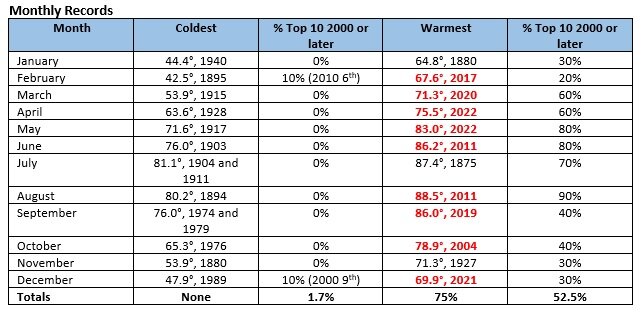
-
Galveston’s Record Warm Late Spring and Early Summer
donsutherland1 replied to donsutherland1's topic in Climate Change
SSTs near Galveston were running 3-4 degrees above normal. -
Morning thoughts… Today will be variably cloudy and noticeably cooler in the northern Mid-Atlantic and southern New England areas. Farther south including Washington, DC to Philadelphia, today will be another hot day. High temperatures will range lower 70s in the northern Mid-Atlantic region to lower 90s from Washington, DC to Philadelphia. Afternoon or evening thundershowers are possible. Likely high temperatures around the region include: New York City (Central Park): 73° Newark: 75° Philadelphia: 90° Tomorrow will be somewhat warmer. A cold front will bring thunderstorms, some of which could be strong. Normals: New York City: 30-Year: 75.4°; 15-Year: 75.8° Newark: 30-Year: 77.1°; 15-Year: 77.7° Philadelphia: 30-Year: 78.8°; 15-Year: 79.3°
-
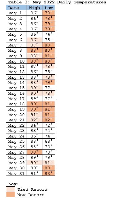
May came to a close with a blaze of heat. Near record and record temperatures were registered across the region. Highs included: Allentown: 92° Atlantic City: 95° Baltimore: 96° Bridgeport: 94° (old record: 91°, 1987 and 2013) Harrisburg: 92° Islip: 93° (old record: 92°, 1987) New Haven: 95° (old record: 87°, 2013) ***New May Record*** New York City-JFK: 94° (old record: 92°, 1988) New York City-LGA: 93° New York City-NYC: 93° Newark: 98° (old record: 96°, 1987) Philadelphia: 96° Poughkeepsie: 93° Scranton: 92° (old record: 91°, 1939 and 2011) Westhampton: 93° (old record: 86°, 2013) White Plains: 92° (old record: 90°, 1987 and 2013) Washington, DC: 96° New York City will finish May with a mean temperature of 64.0°, which is 0.8° above normal. The heat was coming to an abrupt end as a backdoor cold front sliced southwestward. In the wake of the frontal passage, tomorrow will be noticeably cooler. However, much above normal temperatures will likely persist from Philadelphia southward in the Middle Atlantic region through the middle of the week. Galveston is concluding May with monthly mean temperature of 83.0°. That easily breaks the record of 80.4°, which was set in 2018. During May, Galveston recorded 9 90° high temperatures (old record: 4 days, 2011) and 11 80° low temperatures (old record: 4 days, 1996). The first week of June will likely see near seasonable temperatures. Overall, the month will likely wind up warmer than normal. The ECMWF seasonal forecast indicates that the summer will be warmer than normal throughout the region and across much of North America. The ENSO Region 1+2 anomaly was -1.1°C and the Region 3.4 anomaly was -1.0°C for the week centered around May 25. For the past six weeks, the ENSO Region 1+2 anomaly has averaged -1.55°C and the ENSO Region 3.4 anomaly has averaged -1.08°C. La Niña conditions will likely persist through the summer. The SOI was +16.10 today. The preliminary Arctic Oscillation (AO) was -2.281 today. That edges the daily record low of -2.216 from 2016. On May 29 the MJO was in Phase 6 at an amplitude of 1.909 (RMM). The May 28-adjusted amplitude was 1.384 (RMM).
-
Galveston’s Record Warm Late Spring and Early Summer
donsutherland1 posted a topic in Climate Change
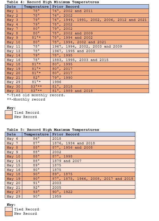
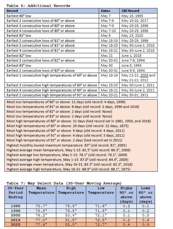
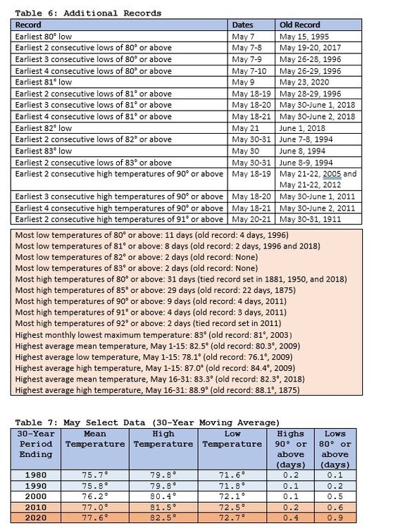
Galveston experienced its warmest December on record last year with a mean temperature of 69.9°, which crushed the old mark of 66.4° that had stood since 1889. The December temperature average was warm enough to qualify as that city's 7th warmest November on record. Since then, one or more record-breaking or record-tying high temperatures were set in each month. April 2022 was the warmest April on record with a mean temperature of 75.5° (old record: 75.0°, 1967 and 2017). Just five months after the historic December warmth, May experienced historic warmth that demolished the monthly record that was set in 2018.The combination of dry conditions, development of a persistent heat dome, and much warmer than normal water temperatures amplified by the impact of climate change produced the record outcome. Summary information on the impacts of climate change in the Houston and Galveston areas can be found here:https://www.globalchange.gov/sites/globalchange/files/CCPR_HOU_brochure-final.pdfFor background information, the mean temperature rose 2.0° at Galveston from the 1961-1990 period to the 1991-2020 period. The number of 90° days rose particularly sharply. Annual temperature: 1961-90: 69.7°; 1991-20: 71.7°Number of days with highs of 80° or above: 1961-90: 151.0 days; 1991-20: 175.7 daysNumber of days with highs of 85° or above: 1961-90: 92.3 days; 1991-20: 126.0 daysNumber of days with highs of 90° or above: 1961-90: 13.5 days; 1991-20: 58.2 daysNumber of days with lows of 80° or above: 1961-90: 52.1 days; 1991-20: 62.3 daysThe last year with fewer than 100 85° days was 1997 when there were 94 such days. The last year with fewer than 20 90° days was 1992 when there were just 7 such days.80° warmth has now been occurring both earlier and later in the season as the "hot" season lengthens.Number of days with highs of 80° or above in March-April: 1961-90: 1.1 days; 1991-20: 4.3 daysNumber of days with highs of 80° or above in November-December: 1961-90: 0.5 days; 1991-20: 1.8 daysThe synoptic pattern, regional drought, and warm sea surface temperatures occurred against the backdrop of a warming climate that was resulting in a dramatic increase in hot days. As a result, May 2022 essentially rewrote the record book for warmth in May. Charts follow: Updates: Warmest first week of June Warmest June 1-15 Warmest June on Record Stations with 3 consecutive record warm months with long periods of record (through June 2022) Summers in Galveston Stations with 3 consecutive record warm months with long periods of records (through July 2022) Hottest July and Month on Record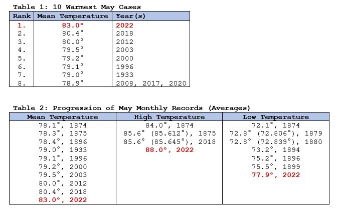

-
The temperature has fallen 7 degrees in the last 5 minutes at Westhampton.
-
5 pm: Bridgeport: 88 New Haven: 73
-
At 3 pm, the temperature at Westhampton was a record 93° with a west wind. 45 miles to the east at Montauk, the temperature had tumbled from 87° to 72° with the wind shifting from west to east. The backdoor cold front will continue to progress south and westward during the remainder of the afternoon. Meanwhile, Newark had reached 97°. That breaks the record of 96°, which was set in 1987.
-
Bridgeport: 93. Old record: 91, 1987 and 2013 Newark: 96 (ties record set in 1987) Islip: 92 (ties record set in 1987)
-
JFK has had a high of 94. That broke its daily record 92 from 1988.
-
JFK has tied its daily record of 92. That record was set in 1988.
-
20/9/5
-
DCA _ NYC _ BOS __ ORD _ ATL _ IAH ___ DEN _ PHX _ SEA 0.3 0.7 0.8 -0.8 0.1 0.4 0.2 2.0 -0.3 104 100 101 100 99 105 100 118 92
-
Morning thoughts… Today will be partly sunny and hot. High temperatures will range from the upper 80s along the coastline to the middle 90s in interior sections. Likely high temperatures around the region include: New York City (Central Park): 93° Newark: 97° Philadelphia: 97° Tomorrow be noticeably cooler in much of the region. Much above normal temperatures will likely persist from Philadelphia southward. Normals: New York City: 30-Year: 75.2°; 15-Year: 75.5° Newark: 30-Year: 76.8°; 15-Year: 77.4° Philadelphia: 30-Year: 78.5°; 15-Year: 79.0°
-
Tomorrow will be a hot day with readings soaring into the 90s in much of the region. However, a backdoor cold front will break the warm spell in parts of the region afterward. As the cold front moves across Long Island, temperatures could plunge by 20°-30° in a matter of hours. Much above normal temperatures will likely persist from Philadelphia southward in the Middle Atlantic region through the middle of the week. Based on sensitivity analysis applied to the latest guidance, Galveston has an implied near 100% probability of recording its warmest May on record. Galveston will likely finish with a monthly mean temperature near 82.9°. The existing record is 80.4°, which was set in 2018. Galveston has already recorded its most 90° high temperatures and 80° low temperatures on record for May. Some of the guidance has suggested that June could be warmer than normal in the Middle Atlantic and New England areas. The latest EPS weeklies suggest otherwise. The ECMWF seasonal forecast indicates that the summer will be warmer than normal throughout the region and across much of North America. The ENSO Region 1+2 anomaly was -1.5°C and the Region 3.4 anomaly was -1.1°C for the week centered around May 18. For the past six weeks, the ENSO Region 1+2 anomaly has averaged -1.65°C and the ENSO Region 3.4 anomaly has averaged -1.07°C. La Niña conditions will likely persist through the summer. The SOI was +31.12 today. That broke the daily record of +25.53 from 2014. The preliminary Arctic Oscillation (AO) was -1.897 today. On May 28 the MJO was in Phase 6 at an amplitude of 1.390 (RMM). The May 27-adjusted amplitude was 1.254 (RMM). Based on sensitivity analysis applied to the latest guidance, there is an implied near 100% probability that New York City will have a warmer than normal May (1991-2020 normal). May will likely finish with a mean temperature near 64.0° (0.8° above normal).
-
Morning thoughts… Today will be partly sunny and very warm. High temperatures will reach the upper 80s and lower 90s in much of the region. Likely high temperatures around the region include: New York City (Central Park): 87° Newark: 91° Philadelphia: 91° Tomorrow will likely see the highest temperatures so far this year in parts of the region. Normals: New York City: 30-Year: 74.9°; 15-Year: 75.3° Newark: 30-Year: 76.5°; 15-Year: 77.1° Philadelphia: 30-Year: 78.2°; 15-Year: 78.7°
-
Much warmer air will move into the region for tomorrow and Tuesday before another cold front breaks the short warm spell. Some parts of the region could see their highest temperatures so far on Tuesday. Much above normal temperatures will likely persist from Philadelphia southward in the Middle Atlantic region through the middle of next week. The temperature reached 90° at Galveston, tying the daily record set in 1959. Based on sensitivity analysis applied to the latest guidance, Galveston has an implied near 100% probability of recording its warmest May on record. Galveston will likely finish with a monthly mean temperature near 82.8°. The existing record is 80.4°, which was set in 2018. Galveston has already recorded its most 90° high temperatures and 80° low temperatures on record for May. Some of the guidance has suggested that June could be warmer than normal in the Middle Atlantic and New England areas. The latest EPS weeklies suggest otherwise. The ECMWF seasonal forecast indicates that the summer will be warmer than normal throughout the region and across much of North America. The ENSO Region 1+2 anomaly was -1.5°C and the Region 3.4 anomaly was -1.1°C for the week centered around May 18. For the past six weeks, the ENSO Region 1+2 anomaly has averaged -1.65°C and the ENSO Region 3.4 anomaly has averaged -1.07°C. La Niña conditions will likely persist into the start of June. The SOI was +27.82 today. That surpassed the daily record of +26.91, which was set in 1994. The preliminary Arctic Oscillation (AO) was -1.164 today. On May 27 the MJO was in Phase 6 at an amplitude of 1.256 (RMM). The May 26-adjusted amplitude was 0.807 (RMM). Based on sensitivity analysis applied to the latest guidance, there is an implied 99% probability that New York City will have a warmer than normal May (1991-2020 normal). May will likely finish with a mean temperature near 64.1° (0.9° above normal).
-
With bright sunshine and temperatures in the middle 70s, the New York Botanical Garden is nearing summer form.


-
Morning thoughts… Today will be partly sunny and warm. High temperatures will reach the upper 70s and lower 80s in much of the region. Likely high temperatures around the region include: New York City (Central Park): 79° Newark: 82° Philadelphia: 84° Tomorrow will be fair and very warm. Normals: New York City: 30-Year: 74.6°; 15-Year: 75.1° Newark: 30-Year: 76.2°; 15-Year: 76.9° Philadelphia: 30-Year: 77.9°; 15-Year: 78.5°
-
The odds increasingly favor a persistent La Niña. We’ll probably see a 3rd consecutive La Niña winter. By mid-summer, the guidance will be in a range where one can have good confidence in the forecast outcome.
-
Tomorrow will be partly sunny and seasonably warm. Much warmer air will move into the region for Monday and Tuesday before another cold front breaks the short warm spell. Much above normal temperatures will likely persist from Philadelphia southward in the Middle Atlantic region through the middle of next week. Based on sensitivity analysis applied to the latest guidance, Galveston has an implied near 100% probability of recording its warmest May on record. Galveston will likely finish with a monthly mean temperature near 82.7°. The existing record is 80.4°, which was set in 2018. Galveston has already recorded its most 90° high temperatures and 80° low temperatures on record for May. Some of the guidance has suggested that June could be warmer than normal in the Middle Atlantic and New England areas. The latest EPS weeklies suggest otherwise. The ECMWF seasonal forecast indicates that the summer will be warmer than normal throughout the region and across much of North America. The ENSO Region 1+2 anomaly was -1.5°C and the Region 3.4 anomaly was -1.1°C for the week centered around May 18. For the past six weeks, the ENSO Region 1+2 anomaly has averaged -1.65°C and the ENSO Region 3.4 anomaly has averaged -1.07°C. La Niña conditions will likely persist into the start of June. The SOI was +13.50 today. The preliminary Arctic Oscillation (AO) was -0.360 today. On May 26 the MJO was in Phase 5 at an amplitude of 0.805 (RMM). The May 25-adjusted amplitude was 0.187 (RMM). Based on sensitivity analysis applied to the latest guidance, there is an implied 95% probability that New York City will have a warmer than normal May (1991-2020 normal). May will likely finish with a mean temperature near 64.1° (0.9° above normal).
-
Some photos:


-
Some very small hail in Larchmont, NY.
-
Tomorrow will be variably cloudy with some showers and thundershowers. Temperatures will reach the middle or upper 70s across the region. Some locations could again approach or reach 80°. Following a seasonably warm weekend, much warmer air will move into the region early next week. Overall, the second half of the month will likely be warmer than normal and there remains some possibility of an overall warm monthly outcome. The potential also exists for several very warm to perhaps hot days. Galveston saw the temperature reach 93° today. That broke the daily record of 90°, which was set in 1922. Galveston has now had 6 90° or above days this month. The old May record of 4 days was set in 2011. Based on sensitivity analysis applied to the latest guidance, Galveston has an implied near 100% probability of recording its warmest May on record. Galveston will likely finish with a monthly mean temperature ranging from 82.3° to 82.8°. The existing record is 80.4°, which was set in 2018. Galveston has already recorded its most 90° high temperatures and 80° low temperatures on record for May. Some of the guidance has suggested that June could be warmer than normal in the Middle Atlantic and New England areas. The latest EPS weeklies suggest otherwise. The ECMWF seasonal forecast indicates that the summer will be warmer than normal throughout the region and across much of North America. The ENSO Region 1+2 anomaly was -1.5°C and the Region 3.4 anomaly was -1.1°C for the week centered around May 18. For the past six weeks, the ENSO Region 1+2 anomaly has averaged -1.65°C and the ENSO Region 3.4 anomaly has averaged -1.07°C. La Niña conditions will likely persist into the start of June. The SOI was +3.92 today. The preliminary Arctic Oscillation (AO) was +0.394 today. On May 25 the MJO was in Phase 5 at an amplitude of 0.185 (RMM). The May 24-adjusted amplitude was 0.463 (RMM). Based on sensitivity analysis applied to the latest guidance, there is an implied 90% probability that New York City will have a warmer than normal May (1991-2020 normal). May will likely finish with a mean temperature near 64.1° (0.9° above normal).