donsutherland1
-
Posts
24,122 -
Joined
Content Type
Profiles
Blogs
Forums
American Weather
Media Demo
Store
Gallery
Everything posted by donsutherland1
-
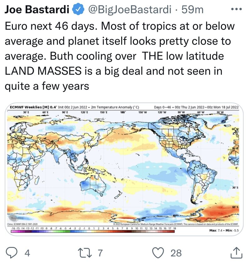
The weather will remain fairly unsettled into at least the first half of the weekend. Showers and thunderstorms will return and continue into tomorrow morning. Parts of the region could pick up 0.50"-1.50" of rain with some locally higher amounts. Overall, temperatures should remain fairly close to normal. No excessive heat appears likely through the weekend. Excessive heat will develop in the desert Southwest by tomorrow. Phoenix will very likely see its first 110° or above temperatures of the year. During 1961-90, Phoenix averaged 15.9 110°+ days per year. For the 1991-20 base period, that number has increased to 20.8 days. During the closing week of May, the MJO moved through Phase 6 with an amplitude as high as 1.909. The only case with an MJO passage through Phase 6 with an amplitude of 1.500 or above during that timeframe was 1998. In 1998, the second half of June was noticeably warmer than the first half. The MJO's ongoing progression and the state of Atlantic blocking could impact the outcome for the second half of June. The ECMWF seasonal forecast indicates that the summer will be warmer than normal throughout the region and across much of North America. Based on how the pattern has been evolving during the spring transition to summer, it is more likely than not that the warmest anomalies of the summer will likely occur in July and August with June being the coolest of the three months in the Northeast. The ENSO Region 1+2 anomaly was -0.6°C and the Region 3.4 anomaly was -0.9°C for the week centered around June 1. For the past six weeks, the ENSO Region 1+2 anomaly has averaged -1.33°C and the ENSO Region 3.4 anomaly has averaged -1.07°C. La Niña conditions will likely persist through the summer. The SOI was +16.17 today. The preliminary Arctic Oscillation (AO) was -1.209 today. On June 6 the MJO was in Phase 8 at an amplitude of 1.858 (RMM). The June 5-adjusted amplitude was 1.945 (RMM). Based on sensitivity analysis applied to the latest guidance, there is an implied 57% probability that New York City will have a warmer than normal June (1991-2020 normal). June will likely finish with a mean temperature near 72.7° (0.7° above normal).
-
Hottest Weather So Far Lies Ahead for Phoenix
donsutherland1 replied to donsutherland1's topic in Central/Western States
Phoenix’s increasing heat is a product of both the urban heat island effect and climate change. The warming has been fairly rapid.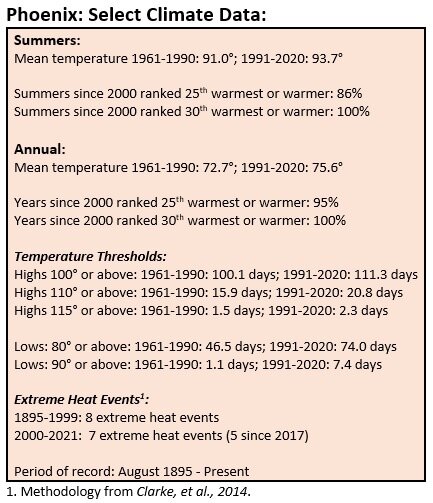
-
Anchorage's Record-Breaking Summer of 2019
donsutherland1 replied to donsutherland1's topic in Climate Change
Anchorage recorded its warmest first week of June on record: Mean temperature: 62.1° (old record: 59.7°, 1997) Average high: 72.3° (old record: 70.0°, 1996) Average low: 51.9° (old record: 51.3°, 1990) -
Galveston’s Record Warm Late Spring and Early Summer
donsutherland1 replied to donsutherland1's topic in Climate Change
Following back-to-back record warm months, Galveston recorded its warmest first week of June on record. The mean temperature was 85.6° (old record: 85.4°, 2008). The average high of 90.7° and average low of 80.4° both ranked second. Record high minimum temperatures were set on June 6 (83°; old record: 81°, 1974, 1990, 2004, 2005, 2008, and 2020) and June 7 (83°; old record: 82°, 1990 and 1994). -
Morning thoughts… Clouds will yield to sunshine. It will be warm. High temperatures will reach the lower and middle 80s in most of the region. Likely high temperatures around the region include: New York City (Central Park): 82° Newark: 86° Philadelphia: 86° Rain and thunderstorms are likely tonight into tomorrow. Normals: New York City: 30-Year: 77.5°; 15-Year: 77.5° Newark: 30-Year: 79.4°; 15-Year: 79.7° Philadelphia: 30-Year: 81.0°; 15-Year: 81.3°
-
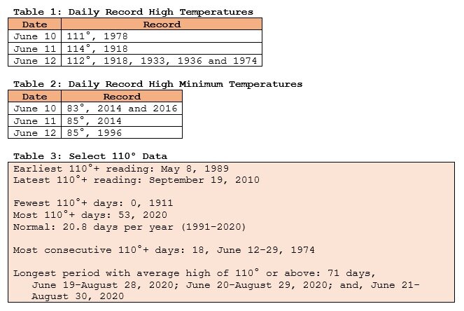
Starting tomorrow, Phoenix will experience its hottest weather so far this year. High temperatures will very likely peak above 110 degrees on multiple days. The hottest days will likely be Friday-Sunday.
-
The weather will remain fairly unsettled into at least the first half of the weekend. Showers, thundershowers, and periods of rain tomorrow. It will likely be a bit warmer. Overall, temperatures should remain fairly close to normal. No excessive heat appears likely through the weekend. Excessive heat will develop in the desert Southwest by Thursday or Friday. Phoenix will likely see its first 110° or above temperatures of the year. During 1961-90, Phoenix averaged 15.9 110°+ days per year. For the 1991-20 base period, that number has increased to 20.8 days. During the closing week of May, the MJO moved through Phase 6 with an amplitude as high as 1.909. The only case with an MJO passage through Phase 6 with an amplitude of 1.500 or above during that timeframe was 1998. In 1998, the second half of June was noticeably warmer than the first half. The MJO's ongoing progression and the state of Atlantic blocking could impact the outcome for the second half of June. The ECMWF seasonal forecast indicates that the summer will be warmer than normal throughout the region and across much of North America. Based on how the pattern has been evolving during the spring transition to summer, it is more likely than not that the warmest anomalies of the summer will likely occur in July and August with June being the coolest of the three months in the Northeast. The ENSO Region 1+2 anomaly was -0.6°C and the Region 3.4 anomaly was -0.9°C for the week centered around June 1. For the past six weeks, the ENSO Region 1+2 anomaly has averaged -1.33°C and the ENSO Region 3.4 anomaly has averaged -1.07°C. La Niña conditions will likely persist through the summer. The SOI was +28.54 today. The preliminary Arctic Oscillation (AO) was -1.421 today. On June 5 the MJO was in Phase 8 at an amplitude of 1.946 (RMM). The June 4-adjusted amplitude was 2.179 (RMM). Based on sensitivity analysis applied to the latest guidance, there is an implied 55% probability that New York City will have a warmer than normal June (1991-2020 normal). June will likely finish with a mean temperature near 72.7° (0.7° above normal).
-
Morning thoughts… Clouds will increase. Showers and periods of rain are likely overnight. High temperatures will reach the upper 70s and lower 80s in most of the region. Likely high temperatures around the region include: New York City (Central Park): 77° Newark: 82° Philadelphia: 81° Additional rain is likely tomorrow. Normals: New York City: 30-Year: 77.2°; 15-Year: 77.2° Newark: 30-Year: 79.1°; 15-Year: 79.4° Philadelphia: 30-Year: 80.7°; 15-Year: 81.0°
-
Anchorage's Record-Breaking Summer of 2019
donsutherland1 replied to donsutherland1's topic in Climate Change
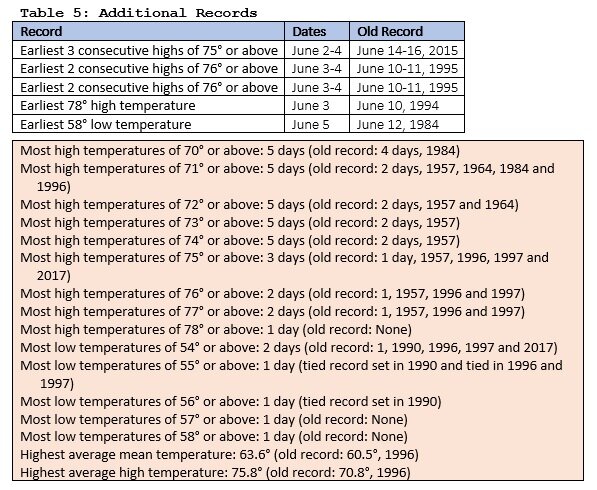
Anchorage just experienced its warmest first five days of June on record. The mean temperature of 63.6° surpassed the old mark by 3.1°. Some charts: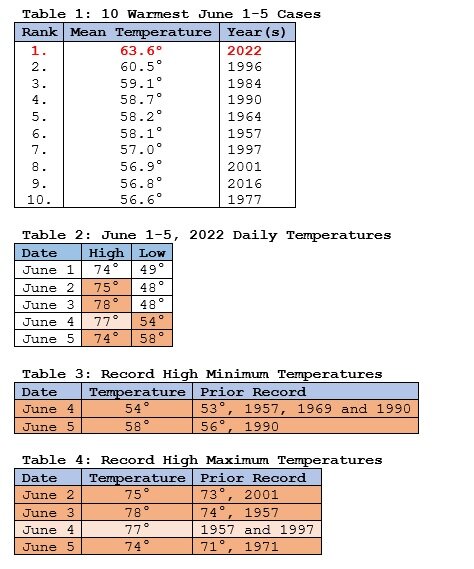
-
The weather will become somewhat more unsettled over the next several days. Temperatures should remain fairly close to normal. No excessive heat appears likely through the weekend. Excessive heat is likely to develop in the desert Southwest late in the week. Phoenix will likely see its first 110° or above temperatures of the year. During 1961-90, Phoenix averaged 15.9 110°+ days per year. For the 1991-20 base period, that number has increased to 20.8 days. During the closing week of May, the MJO moved through Phase 6 with an amplitude as high as 1.909. The only case with an MJO passage through Phase 6 with an amplitude of 1.500 or above during that timeframe was 1998. In 1998, the second half of June was noticeably warmer than the first half. The MJO's ongoing progression and the state of Atlantic blocking could impact the outcome for the second half of June. The ECMWF seasonal forecast indicates that the summer will be warmer than normal throughout the region and across much of North America. Based on how the pattern has been evolving during the spring transition to summer, it is more likely than not that the warmest anomalies of the summer will likely occur in July and August with June being the coolest of the three months in the Northeast. The ENSO Region 1+2 anomaly was -0.6°C and the Region 3.4 anomaly was -0.9°C for the week centered around June 1. For the past six weeks, the ENSO Region 1+2 anomaly has averaged -1.33°C and the ENSO Region 3.4 anomaly has averaged -1.07°C. La Niña conditions will likely persist through the summer. The SOI was +31.35 today. That surpassed the daily record of 26.50, which was set in 2008. It was also the 10th highest daily figure on record for June. The preliminary Arctic Oscillation (AO) was -1.776 today. On June 4 the MJO was in Phase 8 at an amplitude of 2.181 (RMM). The June 3-adjusted amplitude was 2.011 (RMM).
-
Morning thoughts… It will be sunny and warm. High temperatures will reach the lower and middle 80s in most of the region. Likely high temperatures around the region include: New York City (Central Park): 81° Newark: 84° Philadelphia: 84° Clouds will increase tomorrow. There could be some late day or evening showers. Normals: New York City: 30-Year: 76.9°; 15-Year: 77.0° Newark: 30-Year: 78.8°; 15-Year: 79.1° Philadelphia: 30-Year: 80.4°; 15-Year: 80.7°
-
Abundant sunshine and close to seasonable temperatures will again prevail tomorrow. Afterward, the weather will grow somewhat more unsettled. No excessive heat appears likely through at least most of next week. Excessive heat is likely to develop in the desert Southwest late in the week. Phoenix will likely see its first 110° or above temperatures of the year. During 1961-90, Phoenix averaged 15.9 110°+ days per year. For the 1991-20 base period, that number has increased to 20.8 days. During the closing week of May, the MJO moved through Phase 6 with an amplitude as high as 1.909. The only case with an MJO passage through Phase 6 with an amplitude of 1.500 or above during that timeframe was 1998. In 1998, the second half of June was noticeably warmer than the first half. The MJO's ongoing progression and the state of Atlantic blocking could impact the outcome for the second half of June. The ECMWF seasonal forecast indicates that the summer will be warmer than normal throughout the region and across much of North America. Based on how the pattern has been evolving during the spring transition to summer, it is more likely than not that the warmest anomalies of the summer will likely occur in July and August with June being the coolest of the three months in the Northeast. The ENSO Region 1+2 anomaly was -1.1°C and the Region 3.4 anomaly was -1.0°C for the week centered around May 25. For the past six weeks, the ENSO Region 1+2 anomaly has averaged -1.55°C and the ENSO Region 3.4 anomaly has averaged -1.08°C. La Niña conditions will likely persist through the summer. The SOI was +23.62 today. The preliminary Arctic Oscillation (AO) was -2.094 today. On June 3 the MJO was in Phase 8 at an amplitude of 2.010 (RMM). The June 2-adjusted amplitude was 1.994 (RMM).
-
Yes, July 1955 held the record until July 1999.
-
Morning thoughts… It will be sunny and warm. High temperatures will reach the upper 70s and lower 80s in most of the region. Likely high temperatures around the region include: New York City (Central Park): 76° Newark: 81° Philadelphia: 82° Fair weather with near seasonable temperatures will continue through tomorrow. Normals: New York City: 30-Year: 76.6°; 15-Year: 76.7° Newark: 30-Year: 78.4°; 15-Year: 78.8° Philadelphia: 30-Year: 80.1°; 15-Year: 80.4°
-
Abundant sunshine and close to seasonable temperatures will prevail through at least early next week. Tomorrow will likely be the coolest day. No excessive heat appears likely through at least most of next week. Excessive heat is likely to develop in the desert Southwest late next week. Phoenix will likely see its first 110° or above temperatures of the year. During the closing week of May, the MJO moved through Phase 6 with an amplitude as high as 1.909. The only case with an MJO passage through Phase 6 with an amplitude of 1.500 or above during that timeframe was 1998. In 1998, the second half of June was noticeably warmer than the first half. The MJO's ongoing progression and the state of Atlantic blocking could impact the outcome for the second half of June. The ECMWF seasonal forecast indicates that the summer will be warmer than normal throughout the region and across much of North America. Based on how the pattern has been evolving during the spring transition to summer, it is more likely than not that the warmest anomalies of the summer will likely occur in July and August with June being the coolest of the three months in the Northeast. The ENSO Region 1+2 anomaly was -1.1°C and the Region 3.4 anomaly was -1.0°C for the week centered around May 25. For the past six weeks, the ENSO Region 1+2 anomaly has averaged -1.55°C and the ENSO Region 3.4 anomaly has averaged -1.08°C. La Niña conditions will likely persist through the summer. The SOI was +12.30 today. The preliminary Arctic Oscillation (AO) was -2.390 today. The old daily record was -1.919, which was set in 1984. On June 2 the MJO was in Phase 7 at an amplitude of 1.992 (RMM). The June 1-adjusted amplitude was 1.915 (RMM).
-
From Twitter: “Disappearing” the warming. The trick: Use the model’s 1991-2020 baseline without disclosing that baseline is much warmer than those used by the major climate records (GISS, NCDC, Berkeley, HadCrut, etc.). What appears as normal is actually well above normal in the climate record.

-
No. They are all over the place. Most 95-degree readings: Bridgeport: 8, 1949 Islip: 7, 1999 New York City-JFK: 10, 2010 New York City-LGA: 14, 1955 New York City-NYC: 16, 1955 Newark: 25, 1993
-
At Central Park, July 1999 (81.4) is the warmest month. 2010 was 81.3, but the actual figure was likely higher due to the trees shading the instruments.
-
Morning thoughts… It will be sunny and warm. High temperatures will reach the upper 70s and lower 80s in most of the region. Likely high temperatures around the region include: New York City (Central Park): 81° Newark: 85° Philadelphia: 86° Fair weather with near seasonable temperatures will continue into early next week. Normals: New York City: 30-Year: 76.3°; 15-Year: 76.5° Newark: 30-Year: 78.1°; 15-Year: 78.5° Philadelphia: 30-Year: 79.7°; 15-Year: 80.2°
-
Yes. It had 16 such days. 1988 is second with 14. That’s at Central Park.
-
Anchorage's Record-Breaking Summer of 2019
donsutherland1 replied to donsutherland1's topic in Climate Change
Less than 2 years after Anchorage’s historic summer, Anchorage has recorded its earliest streak of 8 consecutive 70-degree days (May 27-June 3). The prior record was set during June 26-July 3, 2019. Today’s preliminary 78-degree high was the earliest such temperature on record. The previous mark was set on June 10, 1995. Meanwhile, Juneau saw its earliest 3 consecutive 80-degree days (June 1-3). The old record was set during June 5-7, 1980. -
The weekend into early next week will feature abundant sunshine and close to seasonable temperatures. Sunday will likely be the coolest day. No excessive heat appears likely through at least most of next week. During the closing week of May, the MJO moved through Phase 6 with an amplitude as high as 1.909. The only case with an MJO passage through Phase 6 with an amplitude of 1.500 or above during that timeframe was 1998. In 1998, the second half of June was noticeably warmer than the first half. The MJO's ongoing progression and the state of Atlantic blocking could impact the outcome for the second half of June. The ECMWF seasonal forecast indicates that the summer will be warmer than normal throughout the region and across much of North America. Based on how the pattern has been evolving during the spring transition to summer, it is more likely than not that the warmest anomalies of the summer will likely occur in July and August with June being the coolest of the three months in the Northeast. The ENSO Region 1+2 anomaly was -1.1°C and the Region 3.4 anomaly was -1.0°C for the week centered around May 25. For the past six weeks, the ENSO Region 1+2 anomaly has averaged -1.55°C and the ENSO Region 3.4 anomaly has averaged -1.08°C. La Niña conditions will likely persist through the summer. The SOI was +1.62 today. The preliminary Arctic Oscillation (AO) was -2.756 today. The previous daily record low was -1.770, which was set in 1985. On June 1 the MJO was in Phase 7 at an amplitude of 1.913 (RMM). The May 31-adjusted amplitude was 1.912 (RMM).
-
Galveston’s Record Warm Late Spring and Early Summer
donsutherland1 replied to donsutherland1's topic in Climate Change
With a high temperature of 90° as of 4 pm CDT, Galveston has now had 6 consecutive days with high temperatures of 90° or above. The 5/29-6/3 period is the earliest such stretch of 6 consecutive days. The old record was 5/31-6/5/1875. -
1955 also saw the kind of strong blocking currently in place during the first 10 days of June.
-
Morning thoughts… Clouds, showers, and mist will give way to increasing sunshine. High temperatures will reach the upper 70s and lower 80s in most of the region. Likely high temperatures around the region include: New York City (Central Park): 78° Newark: 81° Philadelphia: 83° Fair weather with near seasonable temperatures will continue into early next week. Normals: New York City: 30-Year: 76.0°; 15-Year: 76.2° Newark: 30-Year: 77.8°; 15-Year: 78.2° Philadelphia: 30-Year: 79.4°; 15-Year: 79.9°