donsutherland1
-
Posts
21,073 -
Joined
Content Type
Profiles
Blogs
Forums
American Weather
Media Demo
Store
Gallery
Everything posted by donsutherland1
-
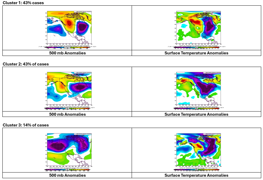
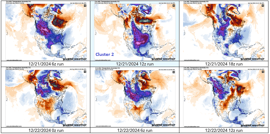
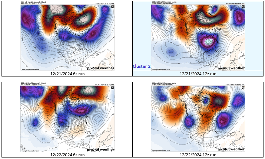
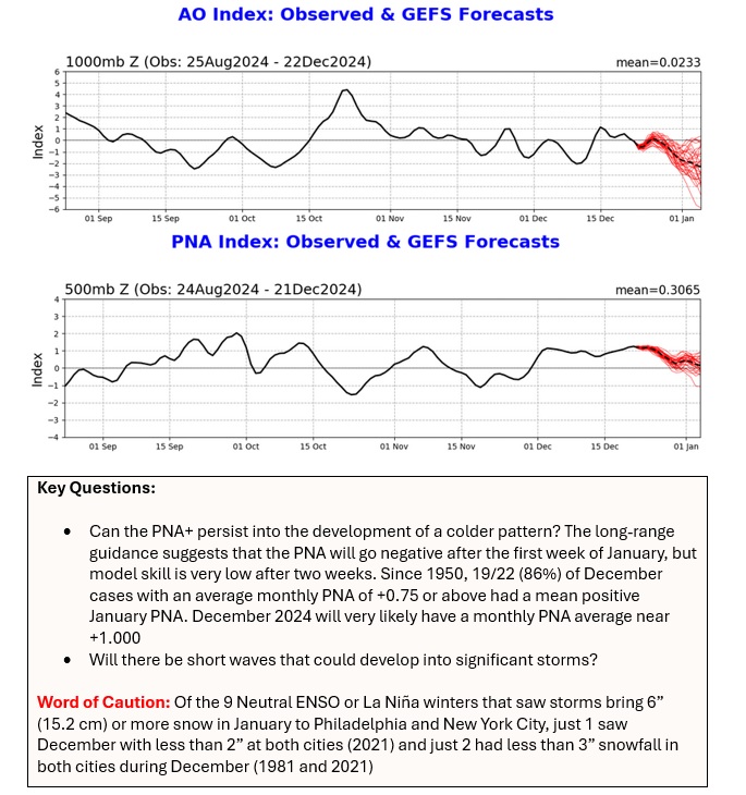
The probability that a colder pattern could begin evolving during the first week of January has increased. That does not guarantee the rapid onset of severe cold. Below are the composite maps for multi-day periods of severe cold during the first half of January since 1980: Below are the 12/21 6z and 12z runs of the GFS vs. the 12/22 6z and 12z runs: Below are the temperature anomalies for the last six runs of the GFS: Key Points: Even as the probability of an evolution toward a colder pattern during the first week of January has increased, that outcome does not mean that there would be a rapid outbreak of severe cold in the eastern half of the CONUS The timeframe involved is still subject to considerable change (as seen in the recent GFS runs) The GFS briefly showed a 500 mb pattern consistent with multi-day shots of severe cold in the eastern half of the CONUS, but has since backed away. Whether that means any such outbreaks would be delayed or that the cold would dump into the West only to reach the East in modified form remains to be seen (the 12z ECMWF still brings the severe cold early with a pattern that is somewhat similar to Cluster 2) The ECMWF weeklies suggest that there will be a multi-week pattern of below normal temperatures in the East, though the CFS is more muted on the outcome Separately, with January opening with a forecast AO-/PNA+ pattern, the potential of moderate (4" or more) or perhaps significant (6" or more) snowfall could increase in an area including Boston, Chicago, Detroit, New York City, Philadelphia, Toronto, and Washington, DC. A persistent PNA+ pattern would be more important for New York City, Philadelphia, and Washington, DC. Needless to say, short waves that would be candidates for such storms would be needed. Those are details that cannot be forecast reliably on multi-week timeframes.
-
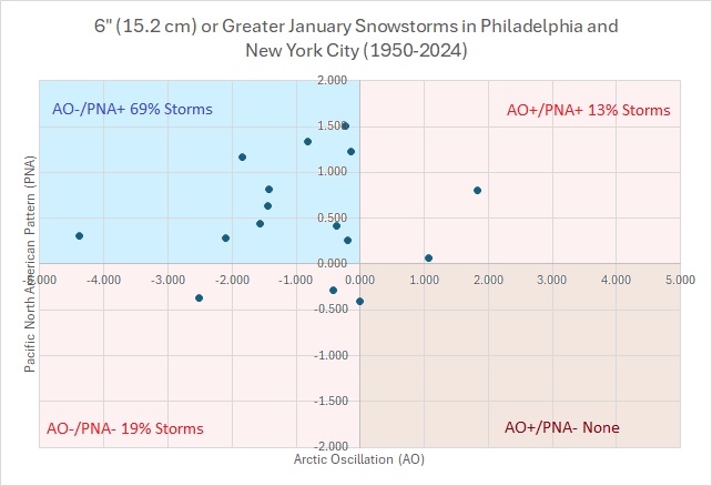
With prospects for a significant snowfall (6"/15.2 cm or above) in Philadelphia and New York City low for the remainder of December, a look ahead at favorable patterns for January is in order. Since 1950, 16 January storms brought 6"/15.2 cm or more snow to both Philadelphia and NYC. Let’s see if January can deliver.
-
Week Ahead: A generally cold but quiet week lies ahead. Temperatures will moderate after midweek.
-
For today's measurable snowfall: JFK: 0.12"; LGA: 0.12"; NYC: 0.15"
-
Yes. That’s correct for Central Park.
-
I thought that it would come in at 2” or a little above based on reports in the Bronx and Manhattan. I suspect that the measurements occurred at 7 am and again at 1 pm, which would miss the snow that fell after 7 am.
-
Unfortunately, a lot of international data is not accessible, so it's difficult to be sure.
-
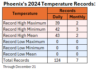
Phoenix also recorded 21 consecutive record-tying or record-breaking high temperatures, by far a new national record. Today, Phoenix has tied its record high (so far). This year, it has tied or broken 124 daily record highs, record high lows, or record high means.
-
New York City received its first measurable snowfall of the year today after seeing only a trace yesterday. Storm total snowfall amounts included: Boston: 5.2" Islip: 2.0" New York City: 1.8" Newark: 2.5" Philadelphia: 0.1" Last winter, New York City's first measurable snowfall occurred on January 6, 2024. The prior winter, it occurred on a record late February 1, 2023. The last earlier first measurable snowfall occurred on December 16, 2020. Normal is December 13th. In the wake of the snowfall, the coldest air so far this season is pouring into the region. The temperature will fall into the teens for the first time this season in New York City and Philadelphia tomorrow morning and then again on Monday morning. Many areas outside those cities will likely experience single-digit lows. High temperatures tomorrow will range from the middle 20s in New York City to the upper 20s in Philadelphia. The cold will begin to recede around the middle of next week. December will likely close with above normal temperatures. The opening days of January will likely also begin with above normal temperatures, but it will start to turn colder. Snowfall prospects will remain limited through the end of December. However, the pattern could become more favorable for moderate or perhaps larger snowfalls as the cold returns during the first week of January. On account of a lack of snowfall, 2023-2024 will likely set a new records for the lowest snowfall over a two-year period for Boston and New York City. Boston: 2023-2024 Total to Date: 26.7"; Record: 38.2", 1979-1980 New York City: 2023-2024 Total to Date: 11.6"; Record: 17.4", 1997-1998 In past days, an occasional run of the operational GFS showed a significant snowstorm from Washington, DC to New York City. However, the pattern makes such an event very unlikely for this region. Since 1950, there were 5 December snowstorms that brought 6" or more snow to all three of these cities. Four (80%) occurred with a PNA+/NAO- pattern. The NAO is forecast to be positive. In addition, three (60%) occurred when the MJO was in Phase 8, which is not likely over the next 10 days. Only the December 23-25, 1966 event produced 6" or more snow in all three cities with a positive NAO, but the AO was strongly negative (< -2.000), which is not likely during the next 10 days. In sum, the interior sections will be far more favored for an appreciable or perhaps greater snowfall than the Washington-Baltimore-Philadelphia-New York City area over the next 10 days. A smaller snowfall remains plausible, as occurred during December 20-21. The NAO fell to a preliminary -2.751 on September 24th (all-time September record: -2.371, September 12, 1971). That was the 9th lowest value on record. La Niña winters following September cases where the NAO fell to -1.900 or below featured a predominantly positive NAO. The most recent such winters were 2016-2017 and 2022-2023. The mean temperatures for those winters in New York City were 39.3° and 41.0° respectively. The 1991-2020 normal value is 36.2°. A warmer to much warmer than normal outcome is favored by the November run of the ECMWF for Winter 2024-2025. The ENSO Region 1+2 anomaly was -0.2°C and the Region 3.4 anomaly was -0.6°C for the week centered around December 11. For the past six weeks, the ENSO Region 1+2 anomaly has averaged +0.17°C and the ENSO Region 3.4 anomaly has averaged -0.27°C. Neutral ENSO conditions may still evolve into a La Niña event during the winter. Uncertainty as to whether a La Niña will actually develop continues to increase. Currently, 47% of dynamical models and 22% of the statistical models forecast the development of a La Niña. The SOI was +12.92 today. The preliminary Arctic Oscillation (AO) was +0.325 today. Based on sensitivity analysis applied to the latest guidance, there is an implied 83% probability that New York City will have a colder than normal December (1991-2020 normal). December will likely finish with a mean temperature near 37.4° (1.7° below normal).
-
Doubtful. Both were strong La Niña events than the current neutral-cool/borderine La Niña. 1998-99 was a strong La Niña event.
-
Some updates on last week’s thoughts: 1. Peak high temperatures were as follows: Baltimore: 64°; Boston: 60° ; Detroit: 54°; New York City: 59°; Newark: 61°; Philadelphia: 63°; Portland, ME: 56°; Washington, DC: 65° 2. No significant (6” or above) snowfalls occurred in the Great Lakes Region or the Middle Atlantic Region. Snowfall amounts included: Baltimore: Trace; Chicago: 2.2”; Detroit: 1.1” ; New York City: 1.8”; Philadelphia: Trace; Toronto: 4.2 cm (1.7”); and, Washington, DC: Trace On December 20-21, a storm brought the season’s first measurable snowfall to New York City and Philadelphia. Amounts were: Boston: 5.2”; New York City: 1.8”; Philadelphia: 0.1”; Baltimore: Trace; and, Washington, DC: Trace. The outcome of a December 20-21 storm in the Mid-Atlantic and southern New England areas was almost identical to that of a system on February 16, 1980 when Boston picked up 5.3” of snow, New York City received 1.6”, and no snow was recorded in Philadelphia, Baltimore, and Washington, DC. 3. During December 17-20, Portland, OR saw temperatures reach 8° or more on each day. The temperature also hit a record high of 60° on December 18th. During December 17-21, Seattle saw temperatures average 7° or above normal on each day. Seattle set a record high of 55° on December 18th and tied the record of 59° on December 20th. Phoenix set record highs of 83° on December 18, December 19, and December 20. That was the first time Phoenix experienced three consecutive 80° readings during the second half of December. The prior latest such streak occurred during December 6-8, 1939. Five thoughts going forward: The strongest cold shot so far this season is overspreading the Mid-Atlantic and southern New England areas. New York City and Philadelphia will see the temperature fall into the teens for the first time this season. It will turn milder near midweek across the Great Lakes, Mid-Atlantic, and New England areas. Chicago could approach or reach 50° by the end of the week. No significant snow is likely from Washington, DC to New York City through the remainder of December. Phoenix will remain on track for its warmest December and warmest year on record. The week ahead will be mild and wet in the Pacific Northwest Long-Range: Colder air will begin to push into the eastern half of the United States during the first week of January. The second week of January has the potential to feature widespread colder-than-normal readings before slow moderation develops near or after mid-month. The pattern could also become more conducive toward bigger snowfalls in the Great Lakes Region eastward to the Middle Atlantic and New England states. Whether there will be storminess to coincide with the cold will remain to be seen, as some of the long-range guidance keeps conditions relatively dry through at least the first week of January. Some of the long-range guidance suggests that an EPO+/AO+/PNA- pattern could develop in late January. That would imply that the month of January could end with warmer than normal readings. Teleconnection forecasts beyond two weeks are not skillful.
-
1998. 2" fell on 12/24/1998. Although the snow depth figure is missing from 12/25, the high and low on 12/24 was 32-23 and it was 33-24 on 12/25. Almost certainly, snow depth was 1" or more on 12/25. Before than, 1983.
-
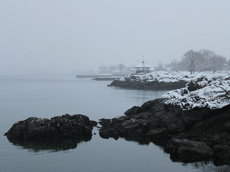
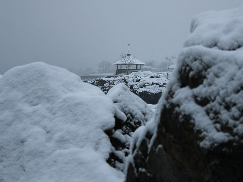
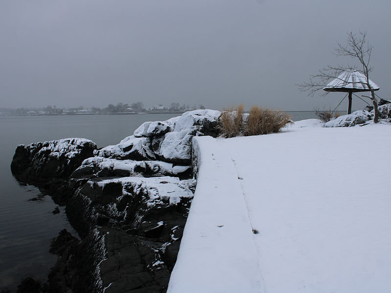
Yes, those photos were taken in Larchmont.
-
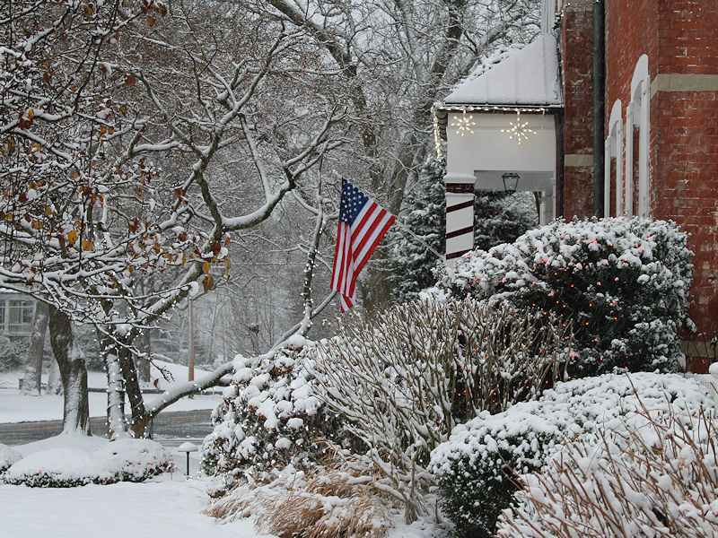
Four photos from a wonderful way to start the winter solstice. As @MJO812 has noted, all snow is good snow.
- 796 replies
-
- 16
-

-
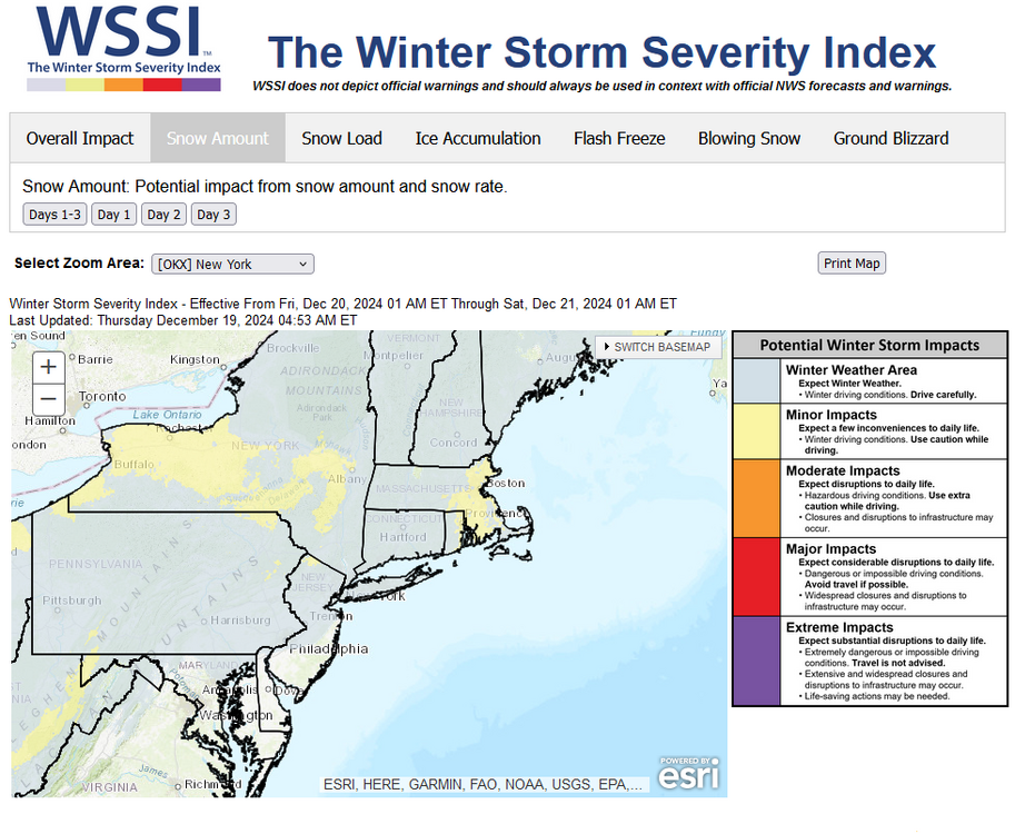
Also: Special Weather Statement National Weather Service New York NY 1053 PM EST Fri Dec 20 2024 CTZ005-009-NYZ070-071-211000- Northern Fairfield-Southern Fairfield-Northern Westchester- Southern Westchester- 1053 PM EST Fri Dec 20 2024 Light snow will develop after midnight and continue into Saturday morning, with 1/2 to 1 inch of snow accumulation. Untreated roadways will be snow covered and hazardous tonight into Saturday morning. Motorists are urged to slow down and use caution traveling tonight into Saturday morning. $$
-
One such storm: December 14-15, 1969: Boston: 3.4"; Philadelphia: 1.5"; Baltimore: 2.0"; Washington, DC: 0.3"; New York City: None
-
12/20-21 Clipper/Coastal Nowcast and Obs
donsutherland1 replied to Boston Bulldog's topic in New England
With 4.4" (11.2 cm) of snow, Boston has seen its record streak without daily snowfall of 4" or more finally come to an end.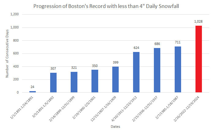
- 620 replies
-
- 15
-
-

-
Parts of the region experienced light snow. Into this evening, snowfall amounts included: Boston: 0.5" Bridgeport: 0.4" New York City: Trace Newark: Trace Philadelphia: Trace Light snow is likely tonight into tomorrow. A coating to an inch of snow is likely in the Philadelphia to New York City region overnight into tomorrow. Boston will likely pick up a storm total 1"-3" of snow. Last winter, New York City's first measurable snowfall occurred on January 6, 2024. The prior winter, it occurred on a record late February 1, 2023. The last earlier first measurable snowfall occurred on December 16, 2020. Normal is December 13th. Afterward, the coldest air so far this season will pour into the region. The temperature will fall into the teens for the first time this season in New York City and Philadelphia on Sunday morning and then again on Monday morning. Many areas outside those cities will likely experience single-digit lows. The cold will begin to recede around the middle of next week. December will likely close with above normal temperatures. The opening days of January will likely also begin with above normal temperatures, but it will start to turn colder. Snowfall prospects will remain limited through the end of December. On account of a lack of snowfall, 2023-2024 will likely set a new records for the lowest snowfall over a two-year period for Boston and New York City. Boston: 2023-2024 Total to Date: 21.5"; Record: 38.2", 1979-1980 New York City: 2023-2024 Total to Date: 9.8"; Record: 17.4:, 1997-1998 In past days, an occasional run of the operational GFS showed a significant snowstorm from Washington, DC to New York City. However, the pattern makes such an event very unlikely for this region. Since 1950, there were 5 December snowstorms that brought 6" or more snow to all three of these cities. Four (80%) occurred with a PNA+/NAO- pattern. The NAO is forecast to be positive. In addition, three (60%) occurred when the MJO was in Phase 8, which is not likely over the next 10 days. Only the December 23-25, 1966 event produced 6" or more snow in all three cities with a positive NAO, but the AO was strongly negative (< -2.000), which is not likely during the next 10 days. In sum, the interior sections will be far more favored for an appreciable or perhaps greater snowfall than the Washington-Baltimore-Philadelphia-New York City area over the next 10 days. A smaller snowfall remains plausible. One example will be the ongoing light snowfall in parts of the region. The NAO fell to a preliminary -2.751 on September 24th (all-time September record: -2.371, September 12, 1971). That was the 9th lowest value on record. La Niña winters following September cases where the NAO fell to -1.900 or below featured a predominantly positive NAO. The most recent such winters were 2016-2017 and 2022-2023. The mean temperatures for those winters in New York City were 39.3° and 41.0° respectively. The 1991-2020 normal value is 36.2°. A warmer to much warmer than normal outcome is favored by the November run of the ECMWF for Winter 2024-2025. The ENSO Region 1+2 anomaly was -0.2°C and the Region 3.4 anomaly was -0.6°C for the week centered around December 11. For the past six weeks, the ENSO Region 1+2 anomaly has averaged +0.17°C and the ENSO Region 3.4 anomaly has averaged -0.27°C. Neutral ENSO conditions may still evolve into a La Niña event during the winter. Uncertainty as to whether a La Niña will actually develop continues to increase. Currently, 47% of dynamical models and 22% of the statistical models forecast the development of a La Niña. The SOI was +24.81 today. The preliminary Arctic Oscillation (AO) was +0.671 today. Based on sensitivity analysis applied to the latest guidance, there is an implied 81% probability that New York City will have a colder than normal December (1991-2020 normal). December will likely finish with a mean temperature near 37.4° (1.7° below normal).
-
Coating in southern Westchester County. Snowing lightly.
-
They are. They've gone a record 1,028 consecutive days without 4" or more daily snowfall (through yesterday). They've also gone 338 consecutive days without 1" of daily snowfall (5th longest snow drought).
-
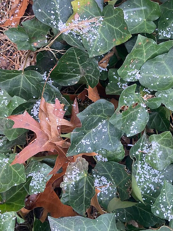
Graupel and rimed snowflakes are now falling in Larchmont, NY. The ground is dusted. I still think NYC is on track for its first measurable snowfall of the winter (coating to an inch).
-
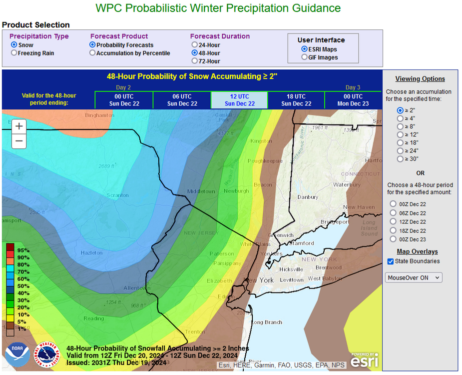
Latest probability map:
-
A cooling trend is underway. That trend will culminate with a sharp shot of cold will during the weekend. The temperature will likely fall into the teens for the first time this season in New York City and Philadelphia. Many areas outside those cities will likely experience single-digit lows. A system will bring some periods of light snow to the region late Friday into early Saturday morning. A coating to an inch of snow is likely in the Philadelphia to New York City region. Boston will likely pick up 1"-3" of snow. There could be an area of enhanced snowfall in parts of the northern Mid-Atlantic or southern New England areas should an inverted trough develop. The cold will begin to recede around the middle of next week. December will likely close with above normal temperatures. The opening days of January will likely also begin with above normal temperatures. Snowfall prospects will remain limited through the end of December. On account of a lack of snowfall, 2023-2024 will likely set a new records for the lowest snowfall over a two-year period for Boston and New York City. Boston: 2023-2024 Total to Date: 21.5"; Record: 38.2", 1979-1980 New York City: 2023-2024 Total to Date: 9.8"; Record: 17.4:, 1997-1998 In past days, an occasional run of the operational GFS showed a significant snowstorm from Washington, DC to New York City. However, the pattern makes such an event very unlikely for this region. Since 1950, there were 5 December snowstorms that brought 6" or more snow to all three of these cities. Four (80%) occurred with a PNA+/NAO- pattern. The NAO is forecast to be positive. In addition, three (60%) occurred when the MJO was in Phase 8, which is not likely over the next 10 days. Only the December 23-25, 1966 event produced 6" or more snow in all three cities with a positive NAO, but the AO was strongly negative (< -2.000), which is not likely during the next 10 days. In sum, the interior sections will be far more favored for an appreciable or perhaps greater snowfall than the Washington-Baltimore-Philadelphia-New York City area over the next 10 days. A smaller snowfall remains plausible. One example will be the upcoming Friday-Saturday snowfall in parts of the region. The NAO fell to a preliminary -2.751 on September 24th (all-time September record: -2.371, September 12, 1971). That was the 9th lowest value on record. La Niña winters following September cases where the NAO fell to -1.900 or below featured a predominantly positive NAO. The most recent such winters were 2016-2017 and 2022-2023. The mean temperatures for those winters in New York City were 39.3° and 41.0° respectively. The 1991-2020 normal value is 36.2°. A warmer to much warmer than normal outcome is favored by the November run of the ECMWF for Winter 2024-2025. The ENSO Region 1+2 anomaly was -0.2°C and the Region 3.4 anomaly was -0.6°C for the week centered around December 11. For the past six weeks, the ENSO Region 1+2 anomaly has averaged +0.17°C and the ENSO Region 3.4 anomaly has averaged -0.27°C. Neutral ENSO conditions may still evolve into a La Niña event during the winter. Uncertainty as to whether a La Niña will actually develop continues to increase. Currently, 47% of dynamical models and 22% of the statistical models forecast the development of a La Niña. The SOI was +29.79 today. The preliminary Arctic Oscillation (AO) was +0.686 today. Based on sensitivity analysis applied to the latest guidance, there is an implied 75% probability that New York City will have a colder than normal December (1991-2020 normal). December will likely finish with a mean temperature near 37.5° (1.6° below normal).
-
There are more models than what is shown on Pivotal, Tropical Tidbits, etc. Here's a link when the NBM was being developed: https://www.weather.gov/news/200318-nbm32 Some of the guidance updates hourly, hence the NBM also updates hourly.
-
The Friday-Saturday light snow event should give Central Park its first measurable snowfall of the season. In fact, the share of ECMWF ensemble members showing 1" or more has decreased since 12/18 12z. Overall, it continues to look like less than 1" of snow in and around NYC and also Philadelphia. Colder suburbs should see a bit more.