donsutherland1
-
Posts
21,073 -
Joined
Content Type
Profiles
Blogs
Forums
American Weather
Media Demo
Store
Gallery
Everything posted by donsutherland1
-
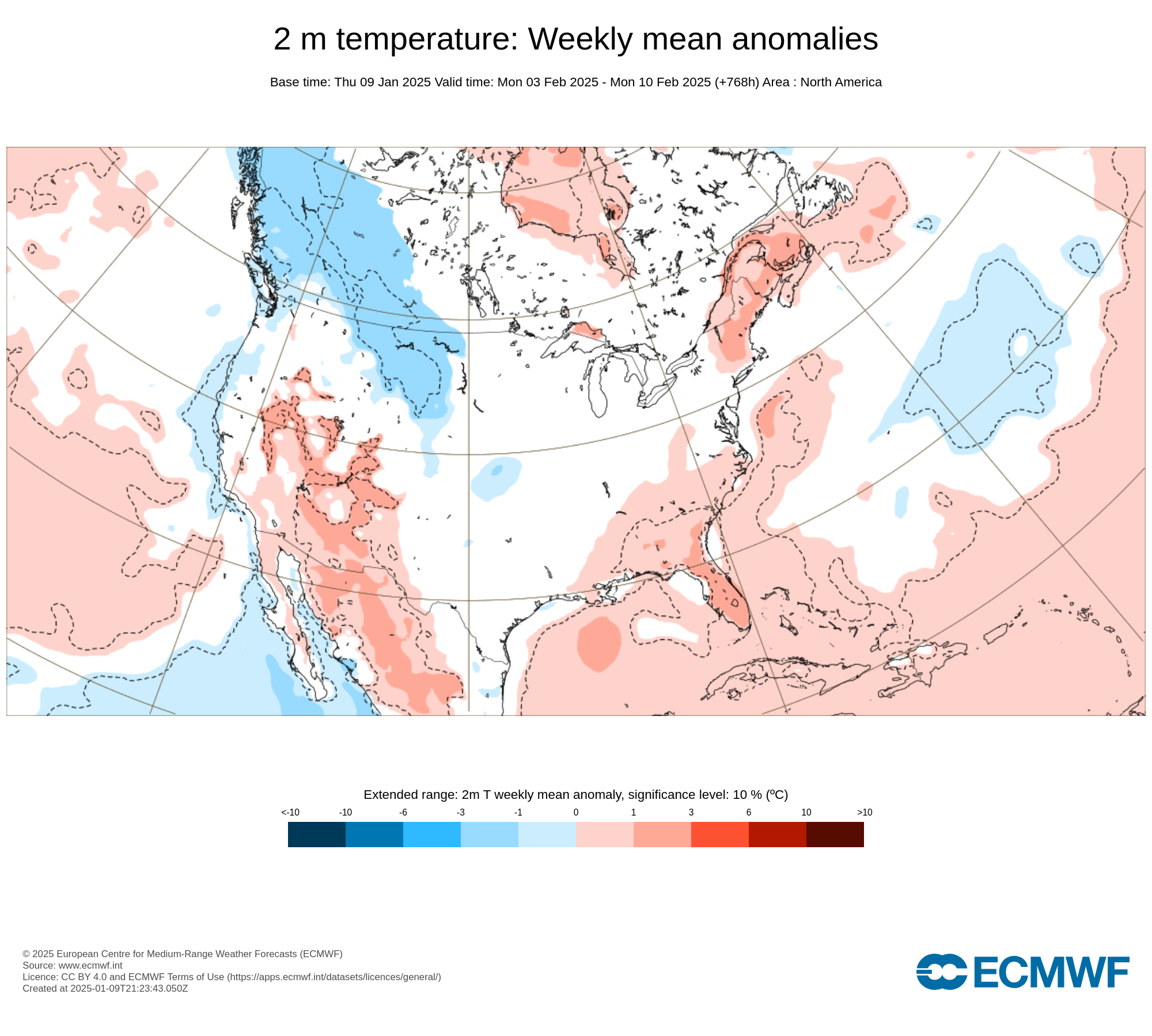
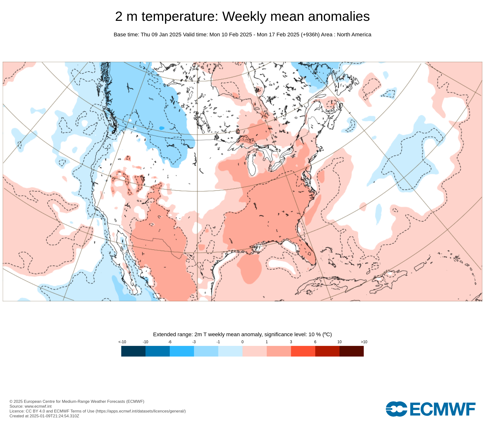
The ECMWF weeklies for weeks 4 and 5 from the ECMWF's site are as follows (I believe those are the maps W. Drag referenced):

-
For reference: https://www.weather.gov/lwx/events_Inauguration
-
Thanks for this info. I had been waiting for the official announcement.
-
There can be differences in the trajectory e.g., Washington, DC has a direct shot of Arctic air. I'm not sure if the tool allows the use of multiple endpoints.
-
The source region of today's air mass:
-
There is a fixed baseline for the long-term climate. For example, GISS uses 1951-80. NOAA uses 1901-99. The climate "normals" serve a different purpose. Their purpose is to convey information what the present climate of a location is like. That's why the climate normals are updated every 10 years (not just in the U.S., but worldwide).
-
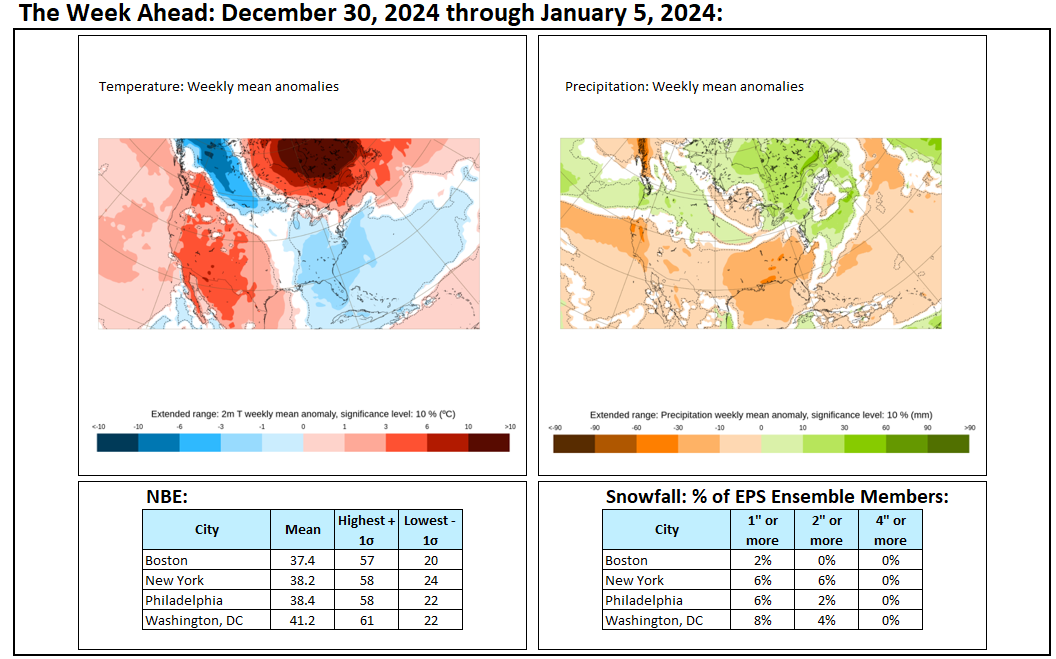
Today was another windy and cold day. Most of the rest of the week will feature generally quiet weather in terms of precipitation. There will be a gusty wind, at times. A developing coastal storm could graze parts of the region during the weekend. Any accumulations will be small. Before then, the storm has the potential to bring Atlanta a minor accumulation of snow on Friday into Saturday. The last time Atlanta experienced a measurable snowfall was December 26, 2022 when 0.1" snow fell. An extended period of generally below normal temperatures is underway in the New York City area. Although this cold regime will likely extend through at least mid-month, the kind of severe cold that produces minimum temperatures below 10° in the Philadelphia to New York City areas is unlikely during that period. The cold could still peak with readings dropping into the teens and several subfreezing highs. The second and third weeks of January will likely feature widespread cold anomalies in much of the eastern half of the CONUS and Canada south of the Hudson and James Bays. The potential exists for widespread cold anomalies of 6°-10° below normal during that week in parts of that region, particularly the Southeast. Those anomalies will likely result more from the prolonged nature of the cold than its severity. However, notable exceptions could be areas with fresh snow cover that experience strong radiational cooling. The ENSO Region 1+2 anomaly was +0.1°C and the Region 3.4 anomaly was -0.7°C for the week centered around January 1. For the past six weeks, the ENSO Region 1+2 anomaly has averaged +0.02°C and the ENSO Region 3.4 anomaly has averaged -0.63°C. Neutral ENSO conditions may still evolve into a La Niña event during the winter. Uncertainty as to whether a La Niña will actually develop persists. On the December 19 outlook, 56% of dynamical models but 0% of the statistical models forecast the development of a La Niña. The SOI was -3.53 today. The preliminary Arctic Oscillation (AO) was -2.332 today. Based on sensitivity analysis applied to the latest guidance, there is an implied 80% probability that New York City will have a colder than normal January (1991-2020 normal). January will likely finish with a mean temperature near 30.3° (3.4° below normal).
-
Jan 11th-12th Super Bomb or Super Bummed?
donsutherland1 replied to Rjay's topic in New York City Metro
The NAO has been negative since January 2.- 993 replies
-
- 5
-

-
- metsfan vs snowman
- bomb
- (and 2 more)
-
It hasn't happened (at least not yet).
-
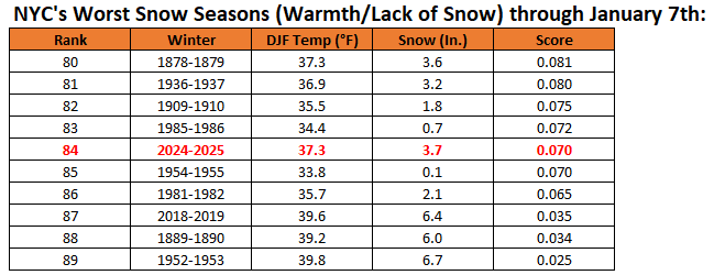
Although snowfall has been disappointing in the New York City area so far, Winter 2024-2025 ranks vastly better than the past two winters in terms of the combination of cold and snow through January 7th. Winter 2022-2023 finished as the second worst (only exceeded by 2001-2002) in terms of warmth and lack of snowfall. Winter 2023-2024 finished as the fourth worst. In contrast, Winter 2024-2025 currently ranks 84th worst, just marginally worse than Winter 1954-1955.
-
I believe it will be tough for January to average below 30° in NYC. We're really not getting cross-polar flow. When the pattern begins to break down late in the month, it will turn milder.
-
Final snowfalls from the January 5-6, 2025 Mid-Atlantic snowstorm included: Baltimore: 6.6" Bridgeport: 0.4" Islip: 0.4" New York City: 0.9" Newark: 0.8" Philadelphia: 1.8" Richmond: 6.0" Washington, DC: 7.2" The last storm to bring 6" or more snow to Baltimore, Richmond, and Washington, DC occurred during January 22-24, 2016. In the wake of the recent snowstorm, the rest of the week will feature quieter weather in terms of precipitation. There will be a gusty wind, at times. A developing coastal storm could graze parts of the region during the weekend. Before then, the storm has the potential to bring Atlanta a minor accumulation of snow on Friday into Saturday. The last time Atlanta experienced a measurable snowfall was December 26, 2022 when 0.1" snow fell. An extended period of generally below normal temperatures is underway in the New York City area. Although this cold regime will likely extend through at least mid-month, the kind of severe cold that produces minimum temperatures below 10° in the Philadelphia to New York City areas is unlikely during that period. The cold could still peak with readings dropping into the teens and several subfreezing highs. The second and third weeks of January will likely feature widespread cold anomalies in much of the eastern half of the CONUS and Canada south of the Hudson and James Bays. The potential exists for widespread cold anomalies of 6°-10° below normal during that week in parts of that region, particularly the Southeast. Those anomalies will likely result more from the prolonged nature of the cold than its severity. However, notable exceptions could be areas with fresh snow cover that experience strong radiational cooling. The ENSO Region 1+2 anomaly was +0.1°C and the Region 3.4 anomaly was -0.7°C for the week centered around January 1. For the past six weeks, the ENSO Region 1+2 anomaly has averaged +0.02°C and the ENSO Region 3.4 anomaly has averaged -0.63°C. Neutral ENSO conditions may still evolve into a La Niña event during the winter. Uncertainty as to whether a La Niña will actually develop persists. On the December 19 outlook, 56% of dynamical models but 0% of the statistical models forecast the development of a La Niña. The SOI was +3.02 today. The preliminary Arctic Oscillation (AO) was -3.440 today. Based on sensitivity analysis applied to the latest guidance, there is an implied 80% probability that New York City will have a colder than normal January (1991-2020 normal). January will likely finish with a mean temperature near 30.3° (3.4° below normal).
-
Will Atlanta See Measurable Snowfall Late This Week? The ensembles show an energetic trough swinging out of Texas Friday morning. The trough and ridge on the West Coast have some similarities to those features on January 21, 1987 when a storm dumped 3.6" of snow on Atlanta and 7.1" at Athens. The forecast air mass is expected to be reasonably similar to that in 1987. Therefore, I suspect that both cities will see measurable snowfall on Friday into Saturday, although I don't believe this storm will rival the 1987 one. A coating to an inch with some locally higher amounts seems reasonable at this time. Atlanta's Measurable Snow Events Since 2015: January 22-23, 2016: 0.3" December 8-9, 2017: 2.3" January 16-17, 2018: 2.4" January 16, 2022: 0.3" January 28, 2022: 0.2" December 26, 2022: 0.1" Athens' Measurable Snow Events Since 2015: January 23, 2016: 0.1" January 17 2018: 1.1" February 8, 2020: 0.5" January 16, 2022: 1.8" January 21, 2022: 0.2"
-
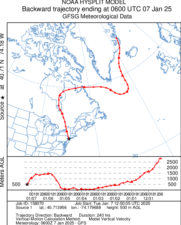
Volcanic Winter, You can find the Hysplit Model at: https://www.ready.noaa.gov/HYSPLIT_traj.php
-
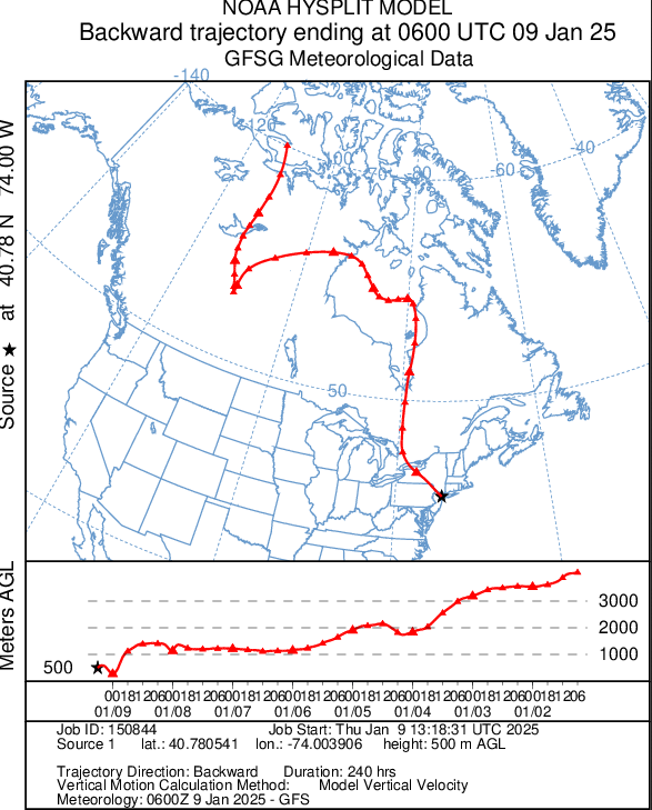
Today's air mass has origins in eastern Greenland.
-
A significant snowstorm continues to bring light snow to parts of the Middle Atlantic region. Snowfall amounts so far, include: Baltimore: 5.8" Bridgeport: 0.4" Islip: 0.4" New York City: 0.9" Newark: 0.8" Philadelphia: 1.8" Richmond: 4.0" Washington, DC: 5.5" An extended period of generally below normal temperatures is underway in the New York City area. Although this cold regime will likely extend through at least mid-month, the kind of severe cold that produces minimum temperatures below 10° in the Philadelphia to New York City areas is unlikely during that period. The cold could still peak with readings dropping into the teens and several subfreezing highs. The second and third weeks of January will likely feature widespread cold anomalies in much of the eastern half of the CONUS and Canada south of the Hudson and James Bays. The potential exists for widespread cold anomalies of 6°-10° below normal during that week in parts of that region, particularly the Southeast. Those anomalies will likely result more from the prolonged nature of the cold than its severity. However, notable exceptions could be areas with fresh snow cover that experience strong radiational cooling. The ENSO Region 1+2 anomaly was +0.1°C and the Region 3.4 anomaly was -0.7°C for the week centered around January 1. For the past six weeks, the ENSO Region 1+2 anomaly has averaged +0.02°C and the ENSO Region 3.4 anomaly has averaged -0.63°C. Neutral ENSO conditions may still evolve into a La Niña event during the winter. Uncertainty as to whether a La Niña will actually develop persists. On the December 19 outlook, 56% of dynamical models but 0% of the statistical models forecast the development of a La Niña. The SOI was +5.33 today. The preliminary Arctic Oscillation (AO) was -3.752 today.
-
Snowfall NYC subforum Jan 6 and OBS if needed
donsutherland1 replied to wdrag's topic in New York City Metro
Final snowfall amounts: BDR: 0.4" EWR: 0.8" ISP: 0.4" JFK: 0.5" LGA: 0.5" NYC: 0.9" -
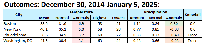
Weekly Outcome: It was somewhat warmer than had been modeled.

-
Snowfall NYC subforum Jan 6 and OBS if needed
donsutherland1 replied to wdrag's topic in New York City Metro
Flurries in the Bronx. -
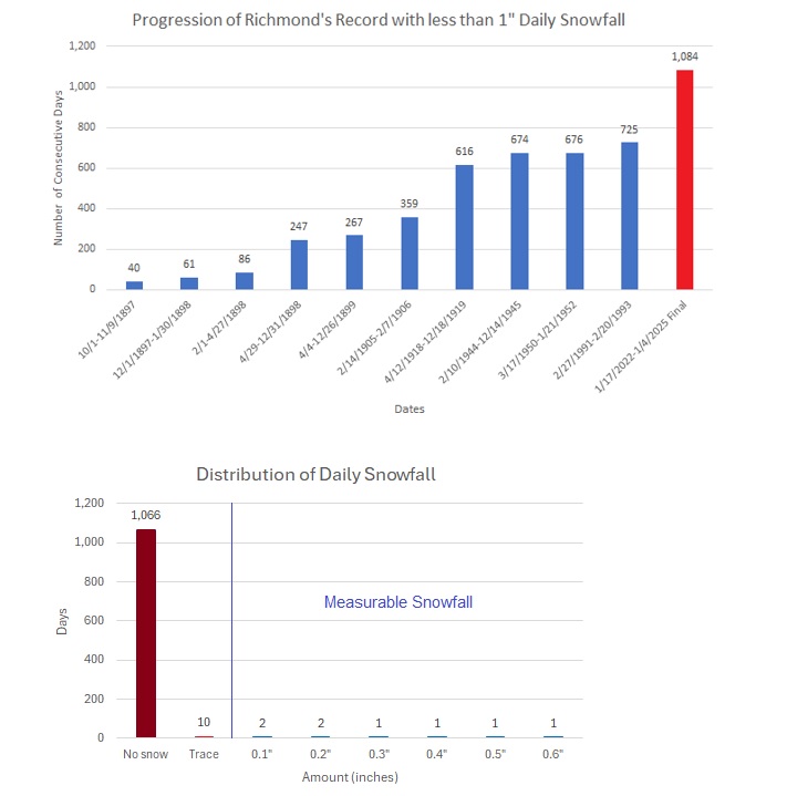
With 4.0” snowfall yesterday, Richmond’s dreadful 1,084-day string without 1” or more daily snowfall finally ended.
-
The far more active subtropical jet during El Niño events facilitates the development of Miller A storms. During La Niña's the subtropical jet is less impactful and often quiet. It's a non-factor with the current storm. Phased solutions and Miller B transitions are more challenging dynamically.
-
There is a slowly building body of literature suggesting that CC impacts the North Pacific Jet. At present, the literature does not appear to rule out favorable winter configurations, but there is a shorter winter-season jet and earlier transition to spring/summer states. Over the long-term, there will likely be a structural decline in seasonal snowfall from warming, as has occurred from DCA southward. However, there will still be a lot of interannual and intraseasonal variability, so opportunities for big snowstorms and snowy seasons will still exist for the forseeable future.
-
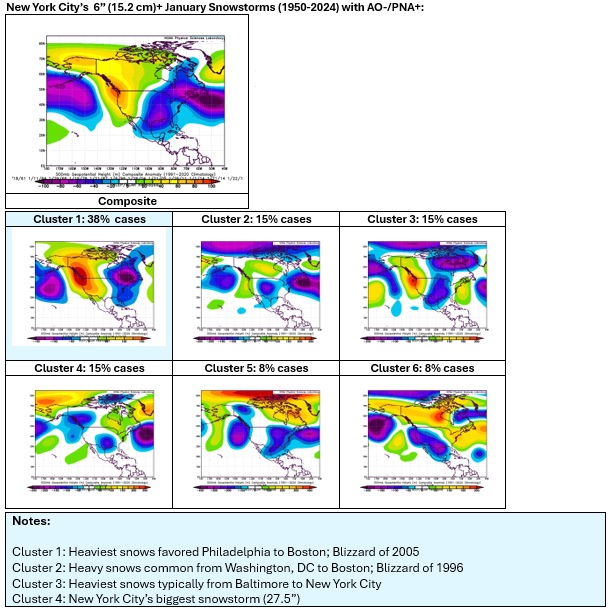
Here are some clusters that provide insight into patterns that can deliver a significant snowfall to NYC:
-
An extended period of generally below normal temperatures is underway in the New York City area. Although this cold regime will likely extend through at least mid-month, the kind of severe cold that produces minimum temperatures below 10° in the Philadelphia to New York City areas is unlikely during that period. The cold could still peak with readings dropping into the teens and several subfreezing highs. A storm will bring parts of the Middle Atlantic region a moderate to locally significant snowfall tonight into tomorrow. Parts of the region will see 4"-8" of snow with locally higher amounts. The focus of the heaviest snows favors the Washington-Baltimore-Annapolis areas. Only minor adjustments were made to the estimated snowfall totals, as the block and confluence have been well-modeled for several days. Final snowfall estimates: Atlantic City: 4"-8" Baltimore: 4"-8" Islip: 0.5" or less (possibly no measurable snow) New York City: 0.5" or less (possibly no measurable snow) Newark: 0.5" or less Philadelphia: 2"-4" Richmond: 1"-3" Washington, DC: 4"-8" This kind of limited focus storm is far more common than storms that bring an extensive significant snowfall from Richmond to Boston. Since 1895, 429 storms have brought 6" or more snowfall to at least one of the following cities: Baltimore, Boston, New York, Philadelphia, Richmond, or Washington, DC. Just 11 (2.6%) brought 6" or more snow to all six of those cities. In terms of even larger snowfalls, just three (0.7%) legendary storms brought 10" or more snowfall to each of those cities: February 11-14, 1899, February 10-12, 1983, and January 6-8, 1996. The second and third weeks of January will likely feature widespread cold anomalies in much of the eastern half of the CONUS and Canada south of the Hudson and James Bays. The potential exists for widespread cold anomalies of 6°-10° below normal during that week in parts of that region, particularly the Southeast. Those anomalies will likely result more from the prolonged nature of the cold than its severity. However, notable exceptions could be areas with fresh snow cover that experience strong radiational cooling. The ENSO Region 1+2 anomaly was -0.2°C and the Region 3.4 anomaly was -1.1°C for the week centered around December 25. For the past six weeks, the ENSO Region 1+2 anomaly has averaged +0.10°C and the ENSO Region 3.4 anomaly has averaged -0.53°C. Neutral ENSO conditions may still evolve into a La Niña event during the winter. Uncertainty as to whether a La Niña will actually develop persists. On the December 19 outlook, 56% of dynamical models but 0% of the statistical models forecast the development of a La Niña. The SOI was +5.80 today. The preliminary Arctic Oscillation (AO) was -3.577 today.
-
The current 500 mb pattern is a good one for the Middle Atlantic region (Washington, DC). It is not consistent with patterns for significant snowfalls for NYC and northward. Patterns conducive to widespread big snows from DCA to BOS are much less uncommon. Overall, the pattern is producing a significant event, just not for the NYC/PHL area.