donsutherland1
-
Posts
21,073 -
Joined
Content Type
Profiles
Blogs
Forums
American Weather
Media Demo
Store
Gallery
Everything posted by donsutherland1
-
Below is the PNS for the 2/13/2024 storm. For most of NYC (except for parts of the Bronx and Brooklyn), this storm will likely be somewhat larger. 934 NOUS41 KOKX 132214 PNSOKX CTZ005>012-NJZ002-004-006-103>108-NYZ067>075-078>081-176>179-141003- Public Information Statement National Weather Service New York NY 514 PM EST Tue Feb 13 2024 ...SNOWFALL REPORTS... Location Amount Time/Date Provider ...Connecticut... ...Fairfield County... 2 SW Newtown 13.8 in 0130 PM 02/13 Trained Spotter 2 NNW Bethel 13.2 in 1200 PM 02/13 Trained Spotter Bethel 11.8 in 1130 AM 02/13 Emergency Mngr 4 SSE Sherman 11.5 in 1215 PM 02/13 Trained Spotter 4 NNE Bethel 11.4 in 0130 PM 02/13 Trained Spotter Sandy Hook 11.1 in 0100 PM 02/13 COCORAHS 4 NNW New Fairfield 10.5 in 1053 AM 02/13 Trained Spotter Newtown 10.2 in 0130 PM 02/13 Trained Spotter 5 ENE Redding 9.7 in 1130 AM 02/13 Trained Spotter 1 SE Wilton 9.2 in 1110 AM 02/13 Public New Canaan 9.2 in 0108 PM 02/13 Trained Spotter Shelton 9.1 in 1259 PM 02/13 Trained Spotter 3 WSW Shelton 8.4 in 1115 AM 02/13 Trained Spotter 4 SSE Easton 8.0 in 1100 AM 02/13 Public Bridgeport Airport 7.6 in 0100 PM 02/13 Official NWS Obs Weston 7.4 in 1237 PM 02/13 Trained Spotter 4 N Stamford 7.0 in 0215 PM 02/13 Cocorahs 3 SSE Greenwich 7.0 in 1117 AM 02/13 Public 3 NNE Stamford 6.5 in 0130 PM 02/13 Trained Spotter Greenwich 6.5 in 0120 PM 02/13 Public 2 N Stamford 6.2 in 1258 PM 02/13 Trained Spotter Norwalk 6.0 in 1100 AM 02/13 Trained Spotter 1 NNW Stamford 6.0 in 1115 AM 02/13 Trained Spotter 1 SE Norwalk 6.0 in 1130 AM 02/13 Trained Spotter 1 NW Rowayton 6.0 in 0119 PM 02/13 Public Stamford 5.5 in 1100 AM 02/13 Trained Spotter ...Middlesex County... Cromwell 11.5 in 1135 AM 02/13 Trained Spotter Durham 10.0 in 1230 PM 02/13 Amateur Radio Chester Center 2.7 WNW 7.5 in 1255 PM 02/13 COCORAHS 1 NNW Killingworth 7.0 in 1230 PM 02/13 Amateur Radio 1 E Westbrook 3.5 in 0350 PM 02/13 Trained Spotter ...New Haven County... Waterbury 12.5 in 1237 PM 02/13 Public Middlebury 11.0 in 0100 PM 02/13 Trained Spotter Wallingford 10.0 in 1230 PM 02/13 Amateur Radio 4 SSE Durham 9.9 in 0245 PM 02/13 Public Hamden 9.1 in 0130 PM 02/13 Trained Spotter 1 N Woodmont 9.0 in 1230 PM 02/13 Amateur Radio Milford 9.0 in 1230 PM 02/13 Amateur Radio Madison 8.6 in 1150 AM 02/13 Trained Spotter North Haven 8.0 in 0210 PM 02/13 Trained Spotter New Haven 8.0 in 1255 PM 02/13 Trained Spotter 1 SSW East Haven 7.5 in 1230 PM 02/13 Amateur Radio 1 WNW Beacon Falls 7.5 in 1230 PM 02/13 Amateur Radio Branford 7.0 in 0127 PM 02/13 Public Branford 6.4 in 0200 PM 02/13 Trained Spotter Guilford 5.5 in 0400 PM 02/13 CO-OP Observer 1 W Clinton 5.0 in 0210 PM 02/13 Trained Spotter ...New London County... Norwich 7.5 in 0220 PM 02/13 Trained Spotter 2 SSE Ledyard Center 6.0 in 0200 PM 02/13 Trained Spotter 1 NNE New London 6.0 in 0300 PM 02/13 Trained Spotter 3 SSE Gales Ferry 5.0 in 0131 PM 02/13 Trained Spotter Griswold 4.0 in 0130 PM 02/13 COCORAHS 4 SW Voluntown 2.3 in 0100 PM 02/13 Public ...New Jersey... ...Bergen County... River Vale 9.8 in 1257 PM 02/13 Trained Spotter Franklin Lakes 9.1 in 1138 AM 02/13 Public Waldwick 9.0 in 0150 PM 02/13 Public 1 ESE Westwood 8.3 in 1200 PM 02/13 Trained Spotter Bergenfield 8.1 in 1235 PM 02/13 Trained Spotter Mahwah 8.0 in 0125 PM 02/13 Public 1 W Fair Lawn 7.0 in 0315 PM 02/13 Public Lyndhurst 6.5 in 0110 PM 02/13 Trained Spotter 1 NNE Rutherford 5.5 in 1230 PM 02/13 Public ...Essex County... Essex Fells 9.5 in 1216 PM 02/13 Public 1 SSW West Orange 8.0 in 1200 PM 02/13 Public 2 NE Springfield 7.1 in 1210 PM 02/13 Public Livingston 7.0 in 1110 AM 02/13 Public 1 N Orange 5.6 in 1134 AM 02/13 Broadcast Media ...Hudson County... Harrison 5.5 in 1148 AM 02/13 CO-OP Observer 2 NE East Newark 5.0 in 1245 PM 02/13 Trained Spotter 1 SW Hoboken 4.8 in 0115 PM 02/13 Cocorahs Hoboken 3.9 in 1245 PM 02/13 Trained Spotter ...Passaic County... Clifton 9.5 in 0217 PM 02/13 Trained Spotter 1 NE West Milford 9.5 in 1155 AM 02/13 Trained Spotter Totowa 8.5 in 0150 PM 02/13 Public ...Union County... New Providence 7.9 in 1226 PM 02/13 Trained Spotter Mountainside 7.5 in 0107 PM 02/13 Public Cranford 6.0 in 0130 PM 02/13 Trained Spotter Plainfield 5.7 in 1200 PM 02/13 Public Rahway 5.0 in 1135 AM 02/13 Trained Spotter Newark Airport 4.9 in 0100 PM 02/13 Official NWS Obs 1 WSW Elizabeth 4.6 in 1208 PM 02/13 Trained Spotter Elizabeth 4.6 in 0216 PM 02/13 Trained Spotter Linden 4.0 in 1141 AM 02/13 Amateur Radio ...New York... ...Bronx County... 1 NNE East Tremont 5.0 in 0228 PM 02/13 Public 1 SSW Parkchester 4.6 in 1245 PM 02/13 Broadcast Media ...Kings County... Coney Island 6.9 in 1132 AM 02/13 Public 1 N Coney Island 6.1 in 1128 AM 02/13 Public Midwood 3.0 in 0145 PM 02/13 Trained Spotter ...Nassau County... Locust Valley 8.7 in 0235 PM 02/13 Public 1 ENE Glen Cove 8.1 in 1134 AM 02/13 Public Muttontown 7.8 in 1234 PM 02/13 Cocorahs Syosset 7.5 in 0124 PM 02/13 Trained Spotter Plainview 7.4 in 0215 PM 02/13 Public Levittown 6.0 in 1214 PM 02/13 Public East Williston 5.7 in 0100 PM 02/13 Public 1 SE Plainview 5.5 in 0145 PM 02/13 Public 1 SSW South Massapequa 5.3 in 1200 PM 02/13 Cocorahs East Meadow 5.2 in 1213 PM 02/13 NWS Employee Hicksville 5.0 in 0110 PM 02/13 Public Floral Park 5.0 in 0234 PM 02/13 Public 1 SE Bethpage 5.0 in 0245 PM 02/13 Public Carle Place 5.0 in 1215 PM 02/13 Amateur Radio 1 ESE Malverne 4.6 in 1150 AM 02/13 Cocorahs ...New York (Manhattan) County... 1 WNW Fordham 6.1 in 1230 PM 02/13 Cocorahs Central Park 3.2 in 0100 PM 02/13 Official NWS Obs ...Orange County... Warwick 13.4 in 0123 PM 02/13 Trained Spotter 1 WNW Monroe 13.0 in 1130 AM 02/13 Trained Spotter Chester 12.8 in 0126 PM 02/13 Cocorahs 2 E Highland Mills 12.7 in 0130 PM 02/13 3 NNE Unionville 11.8 in 1109 AM 02/13 Trained Spotter Salisbury Mills 11.6 in 0100 PM 02/13 Trained Spotter Fort Montgomery 11.0 in 1145 AM 02/13 Trained Spotter 1 ENE Goshen 10.6 in 1130 AM 02/13 Public 2 SSW Stewart Airport 10.4 in 1140 AM 02/13 Public 2 SW Greenwood Lake 10.3 in 1116 AM 02/13 Public Cornwall On Hudson 10.2 in 0200 PM 02/13 COCORAHS West Point 9.7 in 1135 AM 02/13 Trained Spotter 1 SSE Gardnertown 9.1 in 1129 AM 02/13 Public ...Putnam County... 1 N Fahnestock State Park 12.1 in 1150 AM 02/13 Public 3 WNW Fahnestock State Park 11.8 in 1200 PM 02/13 Public Mahopac 11.3 in 1258 PM 02/13 Amateur Radio ...Queens County... Howard Beach 5.7 in 0233 PM 02/13 Trained Spotter 1 W Whitestone 5.2 in 0130 PM 02/13 Public 1 SW Russell Gardens 5.0 in 0345 PM 02/13 Trained Spotter Kennedy Airport 4.2 in 0100 PM 02/13 Official NWS Obs 1 S Elmhurst 3.3 in 1240 PM 02/13 Trained Spotter NYC/La Guardia 3.3 in 0100 PM 02/13 Official NWS Obs ...Richmond County... Westerleigh 3.3 in 0145 PM 02/13 Public ...Rockland County... 1 NW Stony Point 10.5 in 1200 PM 02/13 Cocorahs Nanuet 10.3 in 1200 PM 02/13 Public 1 SE New City 9.7 in 1255 PM 02/13 Public 1 ENE Viola 8.1 in 1130 AM 02/13 Public ...Suffolk County... Commack 8.0 in 0300 PM 02/13 Public 1 E Commack 7.0 in 0140 PM 02/13 Broadcast Media 1 WSW Smithtown 7.0 in 0224 PM 02/13 Public Stony Brook 7.0 in 1230 PM 02/13 NWS Employee Huntington 6.6 in 0108 PM 02/13 Public 2 NNW Ridge 6.5 in 0255 PM 02/13 Trained Spotter 2 N Coram 6.1 in 1115 AM 02/13 Public Smithtown 6.1 in 1254 PM 02/13 Public 1 SSW Miller Place 6.0 in 0200 PM 02/13 Public Centereach 6.0 in 0315 PM 02/13 Official NWS Obs Upton 5.5 in 0100 PM 02/13 Official NWS Obs 1 NNE North Babylon 5.5 in 0145 PM 02/13 Public 1 NNE Greenlawn 5.5 in 1200 PM 02/13 Public Hampton Bays 5.0 in 0330 PM 02/13 Emergency Mngr 1 NE Hauppauge 5.0 in 1100 AM 02/13 Public Mount Sinai 5.0 in 1121 AM 02/13 Public 1 NNW Coram 5.0 in 1242 PM 02/13 Public Brookhaven National Laborato 5.0 in 0100 PM 02/13 Official NWS Obs Islip Airport 4.3 in 0205 PM 02/13 Official NWS Obs Calverton 4.0 in 1240 PM 02/13 Public Riverhead 4.0 in 0200 PM 02/13 Public 3 WNW Aquebogue 3.7 in 0300 PM 02/13 Cocorahs 1 W Jamesport 3.6 in 0252 PM 02/13 Public Mastic 3.5 in 1140 AM 02/13 Public Bay Shore 3.3 in 0201 PM 02/13 NWS Employee Sayville 2.8 in 0132 PM 02/13 Cocorahs ...Westchester County... 1 NNE Peekskill 13.1 in 0133 PM 02/13 Public Peekskill 10.8 in 0109 PM 02/13 Trained Spotter Yorktown Heights 10.0 in 1230 PM 02/13 Public Montrose 9.8 in 1230 PM 02/13 Trained Spotter North Castle 9.5 in 1137 AM 02/13 Public 2 S Mahopac 9.5 in 1215 PM 02/13 Trained Spotter Croton-on-Hudson 9.0 in 0100 PM 02/13 Public 2 N Mamaroneck 8.2 in 0345 PM 02/13 Public 2 NW Woodlawn 8.0 in 0130 PM 02/13 Public 2 NNE Briarcliff Manor 8.0 in 1243 PM 02/13 Public 1 ESE Hartsdale 7.2 in 1230 PM 02/13 Trained Spotter White Plains 7.0 in 1230 PM 02/13 Trained Spotter &&
-
Update: Heavy snow is now falling in Allentown.
-
Yes. Places like Clifton, NJ picked up 9.5" of snow.
-
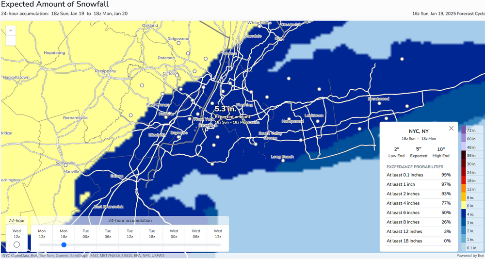
For most of the City (NYC and LGA, included), this should be bigger. JFK got 4.2" on 2/13 last year. I suspect that figure will also be surpassed.
-
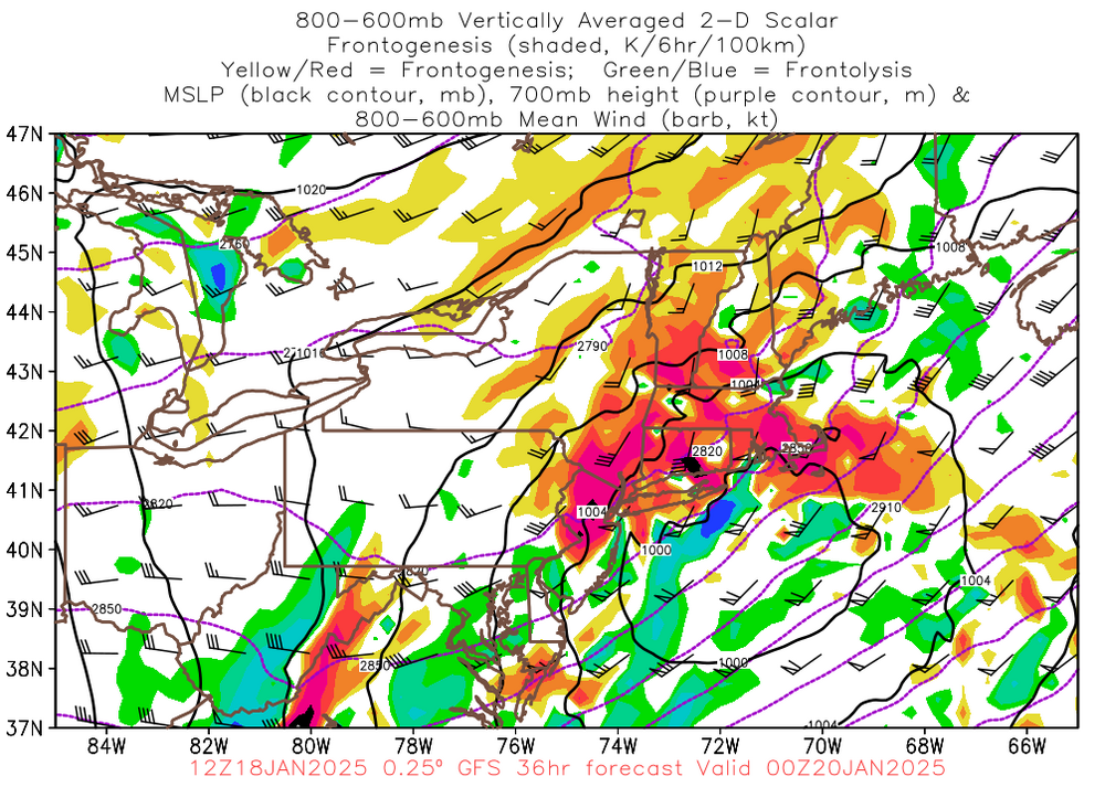
The storm that will bring much of the region its biggest snowfall in nearly three years remains on track... As of 3:20 pm, heavy snow is falling in Harrisburg, Lancaster, and Reading. Moderate snow is falling in Allentown. This snow will progress east-northeastward during the remainder of this afternoon. Steadier accumulating snow will move into Newark and New York City between 4 pm and 5 pm. Snow could fall heavily at times from 6 pm in Newark through 9 pm in New York City. Most of the expected 3"-6" of snow will fall during that timeframe. Snow will taper off to flurries and end near or just after midnight. It will turn much colder overnight with the mercury falling into the lower 20s by tomorrow morning.
-
Flurries in Larchmont.
-
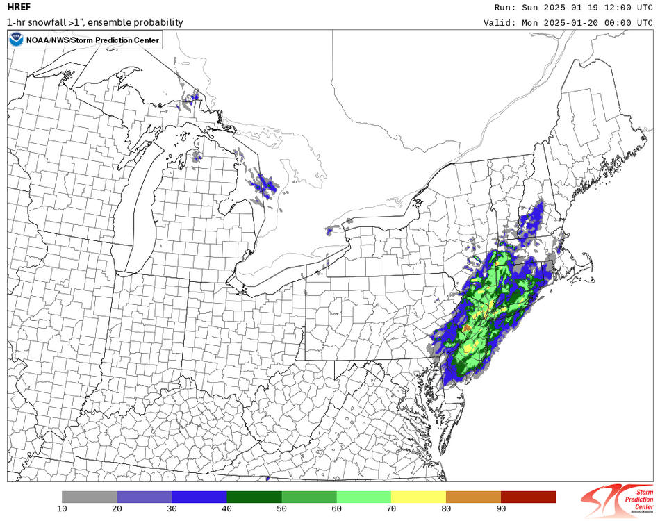
From NWS Probabilistic Precipitation Portal:
-
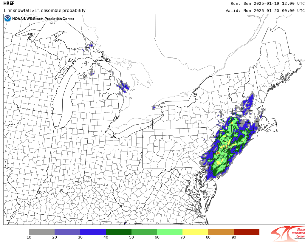
Probably 6:30 - 9:30 this evening in and around the City.
-
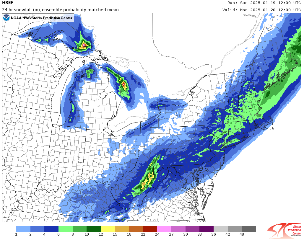
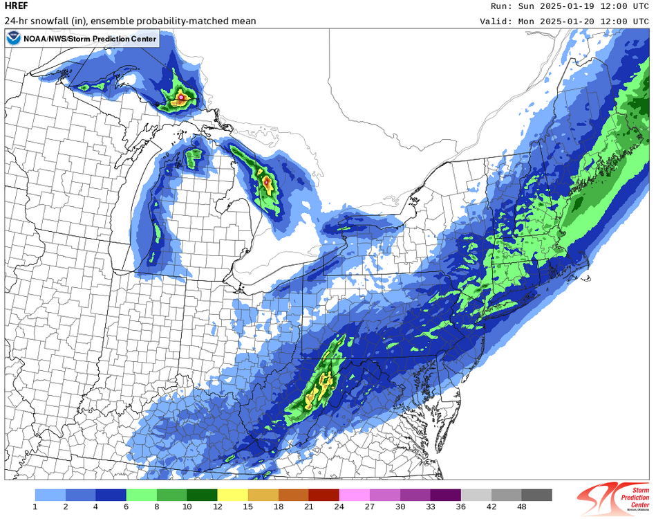
As of now, I have no big changes to my thinking. The Philadelphia to New York City areas remain in line for a 3"-6" snowfall (Boston: 4"-8"). There will likely be an area just north and west of the Philadelphia and New York City areas that sees a general 4"-8" snowfall. Most of the snow will likely fall over a 3-hour period, suggesting the possibility of a period of heavy snow with 1/4-mile or lower visibilities at the peak of the storm (supported by the HREF). The HREF is on the aggressive side of the guidance, but all of the guidance put together suggests a moderate to locally significant snowfall.
-
1899's biggest snows occurred farther up the Eastern Seaboard.
-
December 4, 2009: 0.1".
-
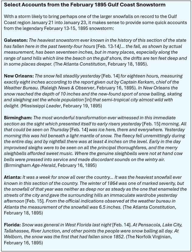
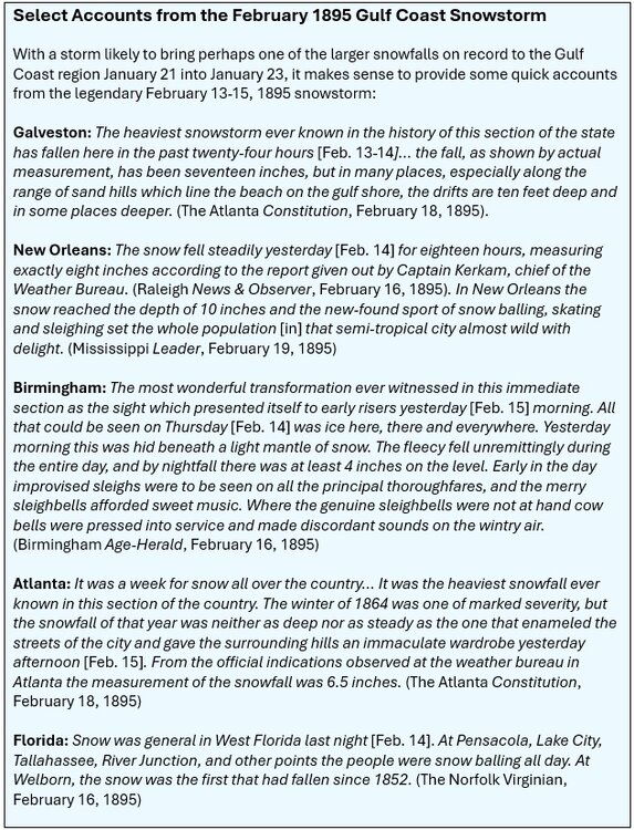
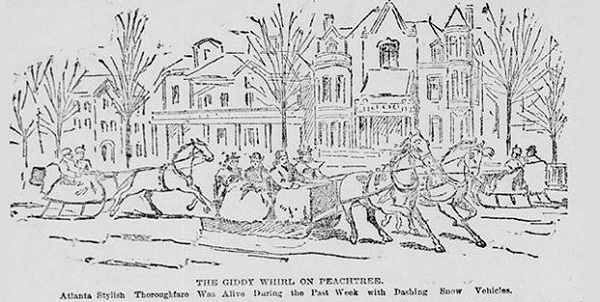
With a rare widespread Gulf Coast snow event possible, some short accounts from the legendary February 1895 snowstorm are below: Source of the Atlanta sleighing scene: The Atlanta Constitution, February 18, 1895.
-
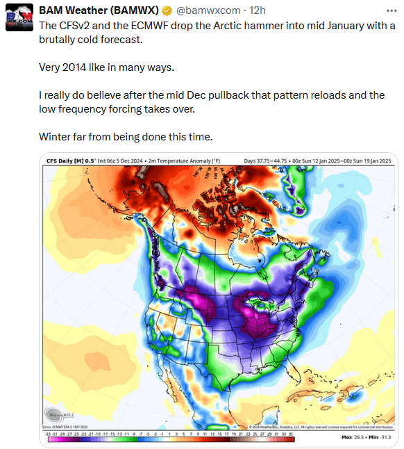
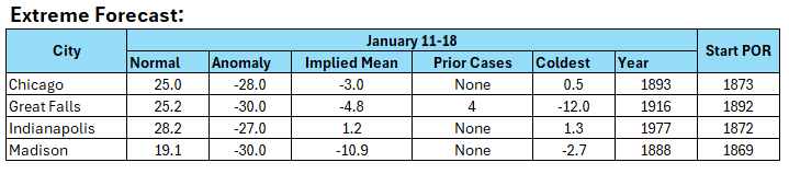
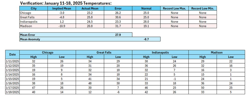
Verification: A map calling for historic cold was posted more than 5 weeks in advance with no understanding of the magnitude of cold relative to historic climatology. It is virtually certain that the site aimed to increase engagement with its hyped call. In the end, BAMWX's forecast met the same fate as General Custer and his army at the Battle of Little Bighorn. The bust was that bad. If anything, the magnitude of the bust was historic in nature. Moreover, as noted in the opening post on the topic, the catastrophe was foreseeable, even as the scale of the bust was even larger than expected. Also, I noted: Further, to show the absurdity of the map, I asked AI (GPT-4o) to generate a random anomaly at tenths of degree fahrenheit using the following prompt: "Generate a random one-week temperature anomaly in tenths of a degree Fahrenheit. The mean long-term anomaly is 0. Assume daily anomalies could range from -50 to +50. The deviations are normally distributed." The random 7-day mean output: -1.7°. I suspect what amounts to a simple guess will also do better. The final four-city anomaly was 0.7° below normal. A random pick blew away the BAMWX forecast. Lessons: 1. Very long-range maps have little skill 2. Due diligence against historic climatology is important for early assessments on likelihood of occurrence 3. The amount of deep cold air in the Northern Hemisphere is important 4. Extreme or historic events require lots of evidence to call for such events In general, Social Media readers should be wary of sites that hype cold, heat, snow, or other extremes. Such reckless sites lack credibility and do damage to perceptions about meteorology, even as the field is remarkably good at what it does if one excludes those who regularly hype events.
-
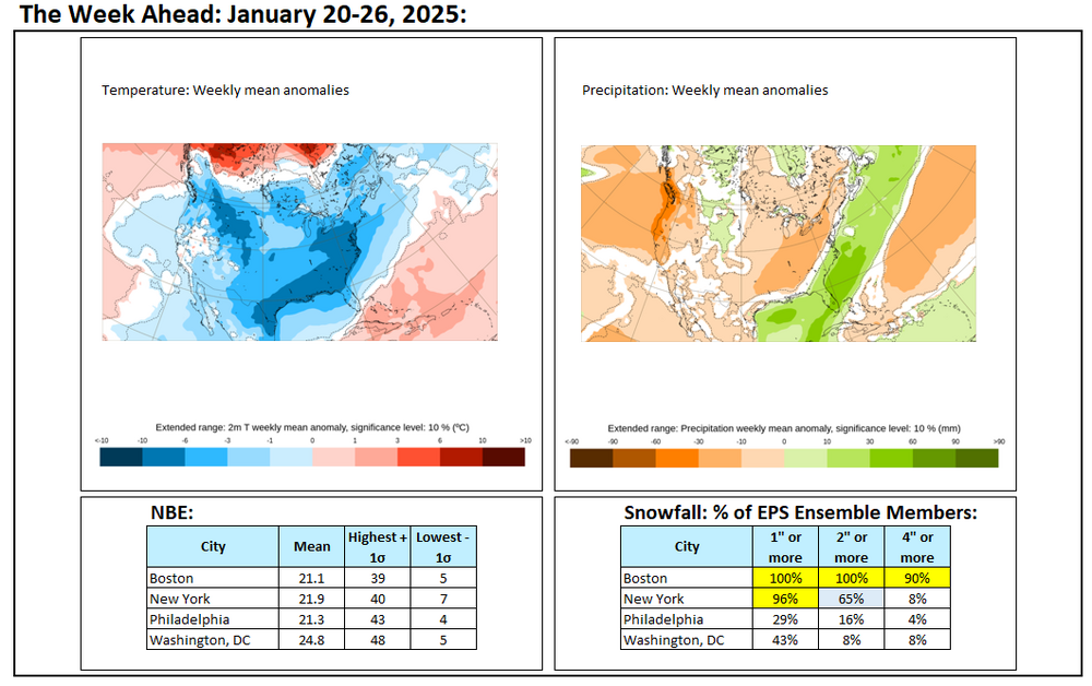
The week ahead: Boston, New York City, Philadelphia, and Washington, DC will likely see their coldest 7-day period since January 3-9, 2018.
-
I don't have any precise accumulations from NYC other than "more than a foot" fell. Washington, DC picked up about 18".
-
There was a news report that the temperature in New York City slowly rose from near 0° to 10° during the blizzard.
-
From The New York Daily Times: For sixteen or seventeen hours the snow fell unceasingly, the wind, during the greater part of the time, blowing nearly a hurricane. The streets at the corners were clean as a bare bone, but where the snow had drifted just beyond, it was from two to five feet deep.
-
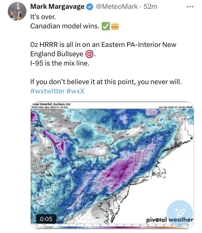
Just another example of bad meteorological information on Social Media. The individual wrote off the I-95 area and expected only mixing. Anyone can make a bad forecast, but one saw bad practice (confirmation bias, selection of a model without consideration of the pattern, and a premature declaration of victory when there was a lot of uncertainty). These examples provide learning experiences for those who wish to forecast, as eliminating bad practices can enhance one's accuracy.
-
An Arctic front will move across the region early tomorrow with some periods of rain and/or snow. Any accumulations should be light. Later in the day a steadier snow will likely overspread the region. The snow could fall moderately to even heavily at times during the first half of tomorrow night. New York City will likely see its heaviest snow during the 6 pm - 8 pm period where visibility could be reduced to 1/4-mile. The developing storm will likely bring a general 3"-6" snowfall from Philadelphia to New York City with a stripe of 4"-8" amounts to the north and west of this region. 1"-3" amounts are likely east of Islip. Select snowfall amounts: Allentown: 4"-8" Baltimore: 2"-4" Boston: 4"-8" Islip: 2"-4" New York City: 3"-6" Newark: 3"-6" Philadelphia: 3"-6" Washington, DC: 2"-4" In the wake of the storm, January will see its first genuine Arctic air mass. During January 20-23, it is likely that New York City will experience its coldest weather this winter. Temperatures could fall into the single digits for lows in New York City, Philadelphia, and perhaps even Washington, DC. The last single-digit lows were as follows: Baltimore: December 24, 2022 (6°) Boston: February 4, 2023 (-10°) New York City: February 4, 2023 (3°) Newark: February 4, 2023 (5°) Philadelphia: December 24, 2022 (7°) Washington, DC: December 24, 2022 (9°) Highs could reach no higher than the teens in New York City and perhaps Philadelphia during the peak of the cold. The last time both cities had high temperatures in the teens was: New York City: December 24, 2022 (15°) Philadelphia: December 24, 2022 (18°) There is a chance that New York City could see two consecutive highs in the teens for the first time since January 6-7, 2018 when the highs were 13° and 18° respectively. New York City and Philadelphia could also be grazed by a storm tracking well south and east of the region from Tuesday into Thursday. That storm has the potential to bring measurable snowfall to Atlanta, Charleston, Norfolk, and Wilmington, NC. The last time that happened was during what became known as the Boxing Day Blizzard of December 25-27, 2010. Parts of the Southeast could see a significant snow, sleet, and ice event from this storm. Tallahassee could see its first snowfall since January 3, 2018 when 0.1" fell. New Orleans could see its first measurable snowfall since December 4, 2009. The last storm that brought measurable snowfall to both New Orleans and Tallahassee occurred on February 9-10, 1973. The AO has now gone negative. With the AO forecast to become predominantly positive after January 24th, prospects for a 6" or above snowstorm in the New York City and Philadelphia areas could become limited after January 24th. Opportunities for a 6" or above snowstorm would likely persist for parts of southern New England, including Boston, through January. Moderation is possible during the last week of January. The ENSO Region 1+2 anomaly was +0.3°C and the Region 3.4 anomaly was -0.7°C for the week centered around January 8. For the past six weeks, the ENSO Region 1+2 anomaly has averaged -0.02°C and the ENSO Region 3.4 anomaly has averaged -0.70°C. La Niña conditions are underway and will likely persist into the start of spring. The SOI was +3.63 yesterday. The preliminary Arctic Oscillation (AO) was -0.203 today. Based on sensitivity analysis applied to the latest guidance, there is an implied 97% probability that New York City will have a colder than normal January (1991-2020 normal). January will likely finish with a mean temperature near 29.8° (4.1° below normal).
-
Report the theft to MJO812.
-
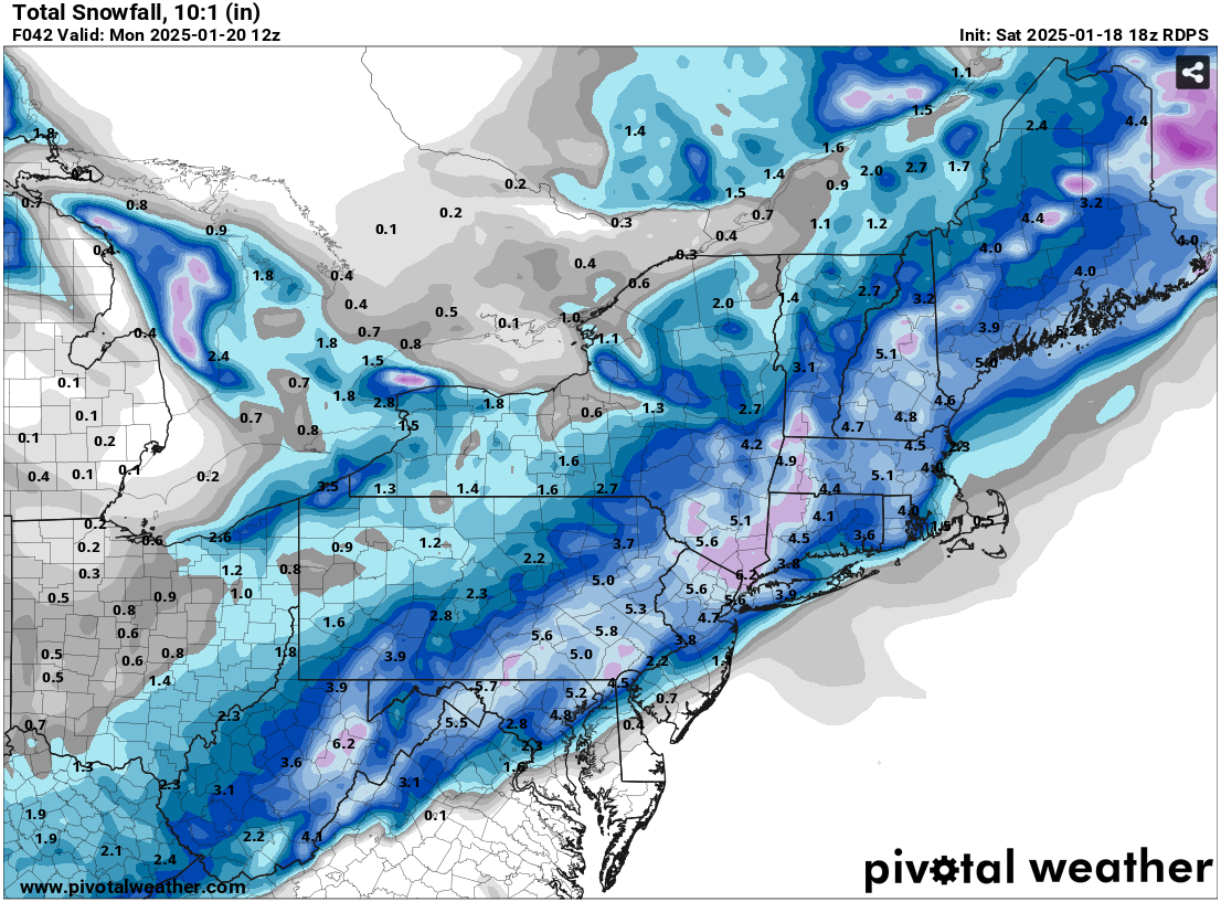
And the RGEM 24 hours later (1/18 18z): Key Points: 1. Don't prematurely verify model outcomes 2. Don't assume model outcomes are locked in stone 3. Consider whether the model solution makes sense given the larger pattern and the other guidance Verification will be provided following the storm


-
For reference:
-
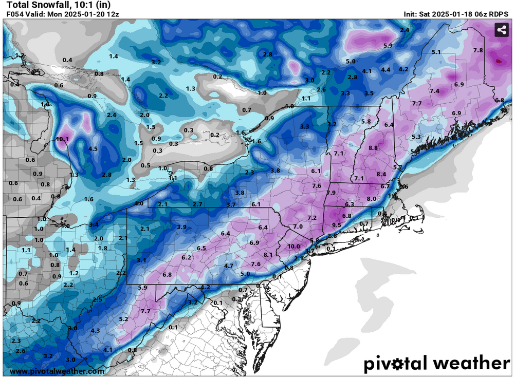
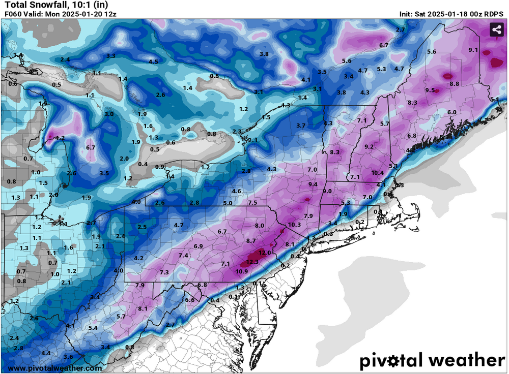
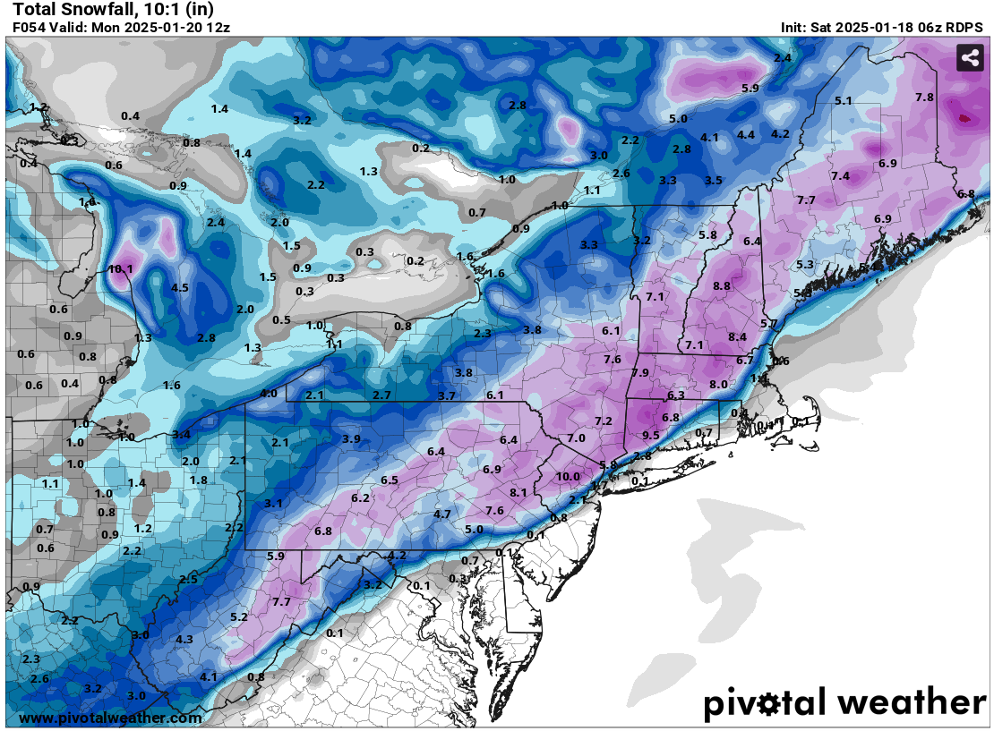
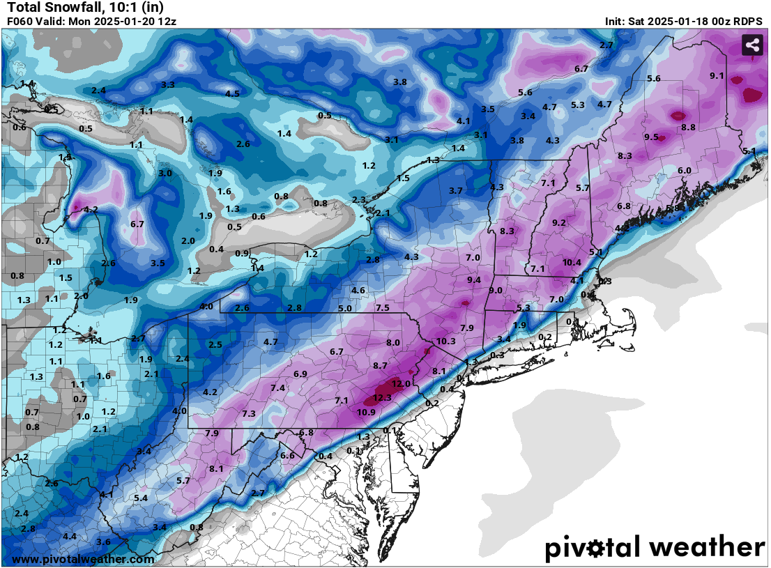
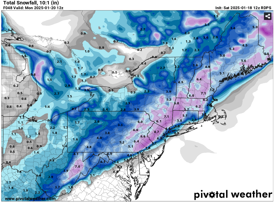
Another Social Media post to be added to the verification pile (BAMWX's call for historic cold will be verified tomorrow): The above post was made yesterday after the 1/18 0z HRRR came out and seemingly supported the 1/17 18z RGEM, which is posted below: Before one prematurely claims verification, possibly based on confirmation bias, one should examine the pattern to see if the particular guidance makes sense. The pattern has some similarities with that of the January 22, 1987 snowstorm, that brought 8.1" to New York City and 8.8" to Philadelphia. This time around, the ridging off the East Coast will be less impressive than it was in 1987 and the storm won't be as moisture-laden. Thus, snowfall amounts will be lower than they were in 1987. At the same time, a mostly rain scenario in New York City is unlikely. My thinking last evening, which incorporated my assessment of the pattern that I posted on this morning and considered all of the guidance: Snow will likely accompany the arrival of the Arctic air to the region. A developing storm will likely bring a general 3"-6" snowfall from Philadelphia to New York City with a stripe of 4"-8" amounts to the north and west of this region. 1"-3" amounts are likely east of Islip. The RGEM is a very good mesoscale model, but it appeared to be an outlier from a general consensus that existed among the guidance. Since then, it has corrected quite aggressively in its 1/18 6z and 12z runs moving into decent agreement with the model consensus.
-
Some updates on last week’s thoughts: 1. Dry weather continued in southern California through. Blythe, Camarillo, Lancaster, Los Angeles, and Palm Springs all saw no rainfall. 2. There was no significant (6”+) snowstorm in the big cities of the Middle Atlantic and southern New England regions (Richmond to Boston) during the upcoming week. The heaviest snowfall amounts for the week were as follows: Baltimore: Trace; Boston: Trace; New York City: Trace; Philadelphia: 0.4“; Richmond: None; and, Washington, DC: 0.1”. 3. A strong cold shot affected the Great Lakes Region Tuesday through Thursday. Indianapolis saw the temperature bottom out at -1°. Detroit saw two consecutive single-digit lows (coldest temperature: 8°). Chicago saw the temperature fall to 5° and three consecutive single-digit lows. Four Thoughts Going Forward: 1. Dry weather will continue in southern California through the week. Little or no rainfall is likely in such cities as Blythe, Camarillo, Lancaster, Los Angeles, and Palm Springs. 2. A snowstorm will affect the Middle Atlantic and southern New England regions (Washington, DC to Boston) later tomorrow into Monday. A general 3”-6” is likely in Boston, New York City, and Philadelphia. A 2”-4” snowfall is likely in Baltimore and Washington, DC. 3. A severe cold shot will affect the Great Lakes Region and East Coast from Sunday through Thursday. Chicago, Detroit, and Indianapolis will all see one or more subzero lows. Baltimore, Boston, New York City, Newark, and Philadelphia will likely see one or more low temperatures in the single digits. Washington, DC could also see the temperature dip below 10°. The last single-digit lows were as follows: Baltimore: December 24, 2022 (6°) Boston: February 4, 2023 (-10°) New York City: February 4, 2023 (3°) Newark: February 4, 2023 (5°) Philadelphia: December 24, 2022 (7°) Washington, DC: December 24, 2022 (9°) Highs could reach no higher than the teens in New York City and perhaps Philadelphia during the peak of the cold. The last time both cities had high temperatures in the teens was: New York City: December 24, 2022 (15°) Philadelphia: December 24, 2022 (18°) There is a chance that New York City could see two consecutive highs in the teens for the first time since January 6-7, 2018 when the highs were 13° and 18° respectively. All in all, this Arctic blast, which will have a Siberian connection, will likely be Winter 2024-2025’s coldest air mass. 4. A storm will likely bring snow to parts of the Deep South Tuesday, Wednesday, and possibly Thursday. Measurable snow is likely in cities including Atlanta, Charleston, and Savannah. There is a chance that Tallahassee could experience its first measurable snowfall since January 3, 2018 when 0.1” fell. New Orleans could see its first measurable snowfall since December 4, 2009. The last storm that brought measurable snowfall to both New Orleans and Tallahassee occurred during February 9-10, 1973. Longer-Range: A slow moderation in temperatures is likely to commence during the closing week of January or the start of February. Above normal temperatures could develop in the eastern quarter of the United States after the first week of February. Precipitation could increase to above normal levels during the last week of February in the Southeast. The Pacific Northwest could see the development of a wet period during the closing days of January or opening of February.
-
The RGEM continues to move toward agreement with the model consensus. 1/18 0z RGEM: 1/18 6z RGEM: 1/18 12z RGEM: