donsutherland1
-
Posts
21,323 -
Joined
Content Type
Profiles
Blogs
Forums
American Weather
Media Demo
Store
Gallery
Everything posted by donsutherland1
-
Tomorrow will be briefly cooler, but it will again turn milder on Tuesday. The generally mild weather will continue into at least the middle of next week, although Monday could be briefly cooler. It will also remain mainly dry into at least the middle of next week. The ENSO Region 1+2 anomaly was +1.2°C and the Region 3.4 anomaly was -0.1°C for the week centered around April 9. For the past six weeks, the ENSO Region 1+2 anomaly has averaged +1.25°C and the ENSO Region 3.4 anomaly has averaged +0.33°C. Neutral ENSO conditions will likely continue through at least late spring. Early indications are that summer 2025 will be warmer than normal in the New York City and Philadelphia areas. The potential exists for a much warmer than normal summer (more than 1° above normal). The SOI was +11.10 today. The preliminary Arctic Oscillation (AO) was +0.953 today. Based on sensitivity analysis applied to the latest guidance, there is an implied 50% probability that New York City will have a warmer than normal April (1991-2020 normal). April will likely finish with a mean temperature near 53.7° (near normal).
-
It probably depends on the exact angle of the wind.
-
I've updated the JFK number. The 5 pm reading came in at 78.
-
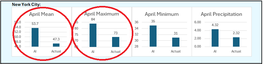
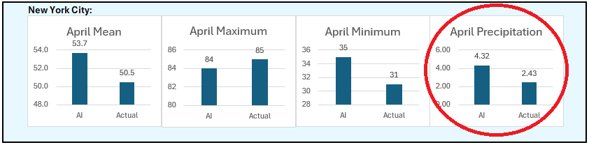
Periodic AI update: Through April 12th: Through April 19th (preliminary): The one area where the AI idea appears to be at the highest risk of being off is April precipitation. Based on sensitivity analysis applied to the latest guidance, the April mean temperature should finish within 1° of the AI estimate. With today's high temperature, the AI estimate for the monthly high temperature is very close to what has occurred.
-
The New York City area experienced an early taste of summer today with the temperature soaring to the highest level so far this year in many parts of the region. Highs included: Islip: 76° New York City-Central Park: 85° New York City-JFK Airport: 78° New York City-LaGuardia Airport: 86° (old record: 85°, 1976 and 2002) Newark: 87° White Plains: 84° The generally mild weather will continue into at least the middle of next week, although Monday could be briefly cooler. It will also remain mainly dry into at least the middle of next week. The ENSO Region 1+2 anomaly was +1.2°C and the Region 3.4 anomaly was -0.1°C for the week centered around April 9. For the past six weeks, the ENSO Region 1+2 anomaly has averaged +1.25°C and the ENSO Region 3.4 anomaly has averaged +0.33°C. Neutral ENSO conditions will likely continue through at least late spring. Early indications are that summer 2025 will be warmer than normal in the New York City and Philadelphia areas. The potential exists for a much warmer than normal summer (more than 1° above normal). The SOI was +0.79 today. The preliminary Arctic Oscillation (AO) was +0.737 today. Based on sensitivity analysis applied to the latest guidance, there is an implied 53% probability that New York City will have a cooler than normal April (1991-2020 normal). April will likely finish with a mean temperature near 53.6° (0.1° below normal).
-
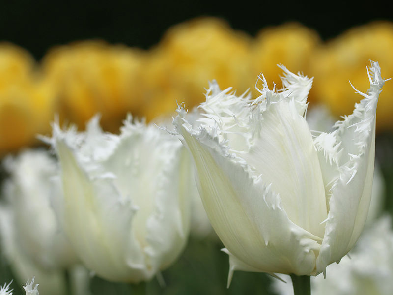
The temperature has soared to 83° so far today in New York City. That's the warmest temperature to date this year. The New York Botanical Garden is filled with blossoms.


-
Tomorrow will be unseasonably warm with readings soaring into the upper 70s and lower 80s in the New York City. The warmest spots will see temperatures approach the middle 80s. The generally mild weather will continue into at least the middle of next week, although Monday could be briefly cooler. It will also remain mainly dry into at least early next week. The ENSO Region 1+2 anomaly was +1.2°C and the Region 3.4 anomaly was -0.1°C for the week centered around April 9. For the past six weeks, the ENSO Region 1+2 anomaly has averaged +1.25°C and the ENSO Region 3.4 anomaly has averaged +0.33°C. Neutral ENSO conditions will likely continue through at least late spring. Early indications are that summer 2025 will be warmer than normal in the New York City and Philadelphia areas. The potential exists for a much warmer than normal summer (more than 1° above normal). The SOI was -13.12 yesterday. The preliminary Arctic Oscillation (AO) was -0.165 today. Based on sensitivity analysis applied to the latest guidance, there is an implied 55% probability that New York City will have a cooler than normal April (1991-2020 normal). April will likely finish with a mean temperature near 53.4° (0.3° below normal).
-
If it stays dry through May and June, then there could be more.
-
I agree with your thinking on 90° or above days. I suspect NYC will finish 2025 with closer to 20 days than 27 days.
-
I believe summer will be warmer than normal and potentially quite hot, but I'm not sure about 1980. 1980 followed a weak El Niño winter.
-
Under brilliant sunshine, the mercury rose into the lower 60s in the New York City area. It will turn even warmer tomorrow. The temperature will rise into the middle and perhaps upper 60s in the New York City area and lower 70s in Philadelphia. Saturday will be unseasonably warm with readings soaring into the upper 70s to near 80° in the New York City. The warmest spots will see temperatures top out in the lower 80s. The mild weather will continue into at least the start of next week, although Monday could be briefly cooler. It will also remain mainly dry into at least early next week. The ENSO Region 1+2 anomaly was +1.2°C and the Region 3.4 anomaly was -0.1°C for the week centered around April 9. For the past six weeks, the ENSO Region 1+2 anomaly has averaged +1.25°C and the ENSO Region 3.4 anomaly has averaged +0.33°C. Neutral ENSO conditions will likely continue through at least late spring. Early indications are that summer 2025 will be warmer than normal in the New York City and Philadelphia areas. The potential exists for a much warmer than normal summer (more than 1° above normal). The SOI was -10.74 today. The preliminary Arctic Oscillation (AO) was -1.028 today. Based on sensitivity analysis applied to the latest guidance, there is an implied 60% probability that New York City will have a cooler than normal April (1991-2020 normal). April will likely finish with a mean temperature near 53.1° (0.6° below normal).
-
A strong cold front moved off the East Coast on April 15th with snow being reported in parts of Georgia, South Carolina, and North Carolina. The stage was then set for an Interior snowstorm during April 18-20. During that storm, Litchfield County in Connecticut picked up 6" (15.2 cm) of snow. The Catskills saw two feet (61.0 cm).
-
The second system brought a trace of snow to Caribou. The total snowfall for the two systems was 2.6".
-
Tomorrow will be another cool day with highs in the upper 50s to near 60°. Afterward, it will turn warmer. Saturday could be unseasonably warm with readings soaring into the 70s in the New York City area. Some of the warmer spots in New Jersey could approach or reach 80°. The mild weather will continue into at least the start of next week. It will also remain mainly dry into at least early next week. The ENSO Region 1+2 anomaly was +1.2°C and the Region 3.4 anomaly was -0.1°C for the week centered around April 9. For the past six weeks, the ENSO Region 1+2 anomaly has averaged +1.25°C and the ENSO Region 3.4 anomaly has averaged +0.33°C. Neutral ENSO conditions will likely continue through at least late spring. Early indications are that summer 2025 will be warmer than normal in the New York City and Philadelphia areas. The potential exists for a much warmer than normal summer (more than 1° above normal). The SOI was -3.17 today. The preliminary Arctic Oscillation (AO) was -0.671 today. Based on sensitivity analysis applied to the latest guidance, there is an implied 57% probability that New York City will have a cooler than normal April (1991-2020 normal). April will likely finish with a mean temperature near 53.1° (0.6° below normal).
-
New Rochelle this evening.
-
Somewhat cooler air will move into the region tonight. Highs tomorrow will reach the lower 50s in New York City and then upper 50s on Thursday. Milder air will likely return to end the week. Saturday could be unseasonably warm with readings soaring into the 70s in the New York City area. Some of the warmer spots in New Jersey could approach or reach 80°. The mild weather will continue into at least the start of next week. The ENSO Region 1+2 anomaly was +1.2°C and the Region 3.4 anomaly was -0.1°C for the week centered around April 9. For the past six weeks, the ENSO Region 1+2 anomaly has averaged +1.25°C and the ENSO Region 3.4 anomaly has averaged +0.33°C. Neutral ENSO conditions will likely continue through at least late spring. Early indications are that summer 2025 will be warmer than normal in the New York City and Philadelphia areas. The potential exists for a much warmer than normal summer (more than 1° above normal). The SOI was +3.03 today. The preliminary Arctic Oscillation (AO) was +0.383 today. Based on sensitivity analysis applied to the latest guidance, there is an implied 60% probability that New York City will have a cooler than normal April (1991-2020 normal). April will likely finish with a mean temperature near 53.0° (0.7° below normal).
-
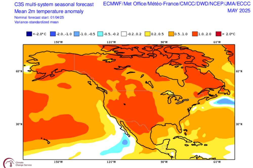
May Ideas from the ECMWF and C3S Multi-Model Suite: C3S:

-
Under partly sunny skies, the temperature suged into the 60s across the New York City area. Highs included: Bridgeport: 62° Islip: 67° New York City-Central Park: 66° New York City-JFK Airport: 62° New York City-LaGuardia Airport: 65° Newark: 67° Tomorrow will be another warmer than normal day before a fresh push of somewhat cooler air moves into the region for the middle of the week. A shower or even thundershower is possible tomorrow. Milder air will likely return to end the week. Saturday could be unseasonably warm with readings soaring into the 70s in the New York City area. The ENSO Region 1+2 anomaly was +1.2°C and the Region 3.4 anomaly was -0.1°C for the week centered around April 9. For the past six weeks, the ENSO Region 1+2 anomaly has averaged +1.25°C and the ENSO Region 3.4 anomaly has averaged +0.33°C. Neutral ENSO conditions will likely continue through at least late spring. Early indications are that summer 2025 will be warmer than normal in the New York City and Philadelphia areas. The potential exists for a much warmer than normal summer (more than 1° above normal). The SOI was +3.53 today. The preliminary Arctic Oscillation (AO) was +1.307 today. Based on sensitivity analysis applied to the latest guidance, there is an implied 61% probability that New York City will have a cooler than normal April (1991-2020 normal). April will likely finish with a mean temperature near 52.8° (0.9° below normal).
-
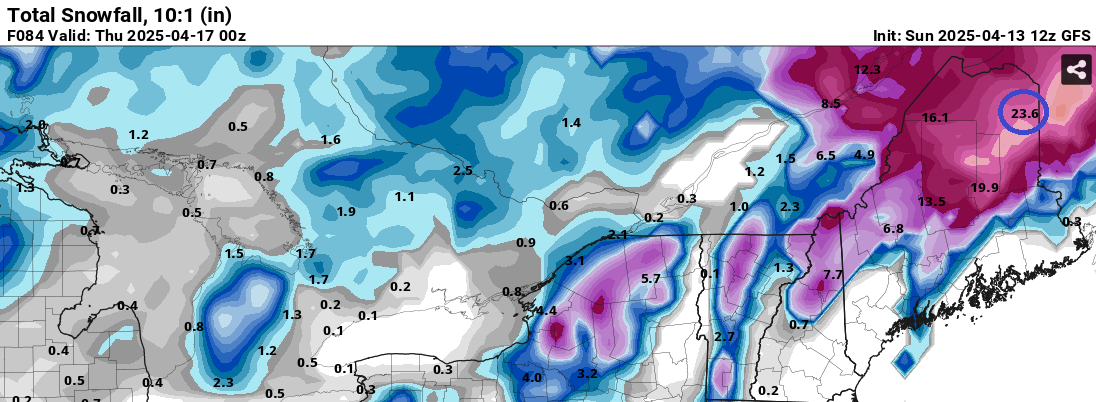
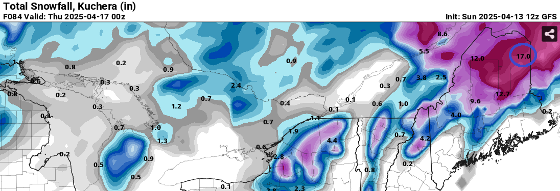
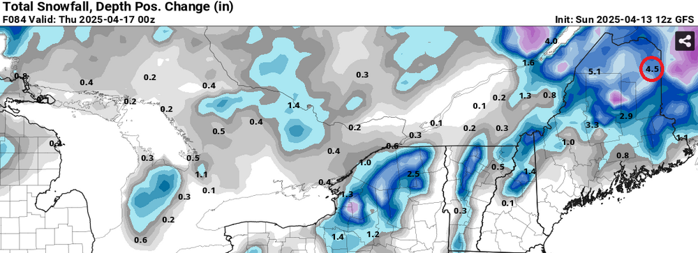
Since 4/13 18z, Caribou picked up 2.6" of snow. The next event of the two systems will bring very little snow and mainly rain/mixed precipitation. In contrast, the 4/13 18z GFS had shown the following amounts for snowfall during the period during which 2.6" fell: 10:1 ratio: 10.9"; Kuchera: 8.4"; and Snow Depth Change: 3.1".


-
Further illustration of the GFS's late-spring cold bias. 84-hour total snowfall forecasts for Caribou from 4/13 18z: Best guess, excluding today's snowfall prior to 18z (0.4"), one is probably dealing with a 1"-3" total snowfall for Caribou from the two waves of precipitation (tonight into tomorrow and then again Tuesday into Wednesday). Most of the time, readings will be above freezing.
-
Tomorrow and Tuesday will be somewhat warmer than normal before another surge of cooler air moves into the region by the middle of the week. Milder air will likely return to end the week. The ENSO Region 1+2 anomaly was +1.3°C and the Region 3.4 anomaly was -0.1°C for the week centered around April 2. For the past six weeks, the ENSO Region 1+2 anomaly has averaged +1.23°C and the ENSO Region 3.4 anomaly has averaged +0.17°C. Neutral ENSO conditions will likely continue through at least late spring. Early indications are that summer 2025 will be warmer than normal in the New York City and Philadelphia areas. The potential exists for a much warmer than normal summer (more than 1° above normal). The SOI was +4.69 today. The preliminary Arctic Oscillation (AO) was +2.029 today. Based on sensitivity analysis applied to the latest guidance, there is an implied 65% probability that New York City will have a cooler than normal April (1991-2020 normal). April will likely finish with a mean temperature near 52.6° (1.2° below normal).
-
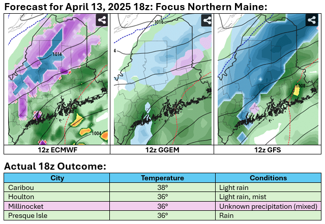
During late spring, the GFS often has a significant cold bias that feeds back leading to excessive snowfall forecasts. That bias is most pronounced in medium-range forecasts (>5 days), but can affect even very short-range ones. Below are 6-hour forecasts:
-
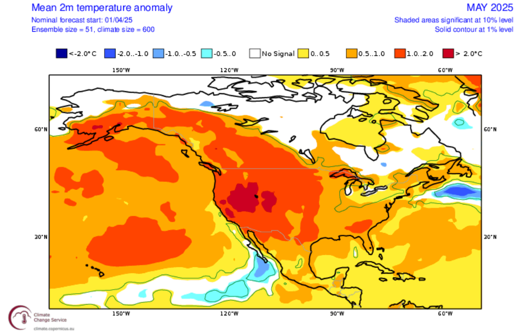
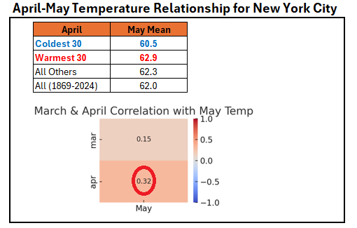
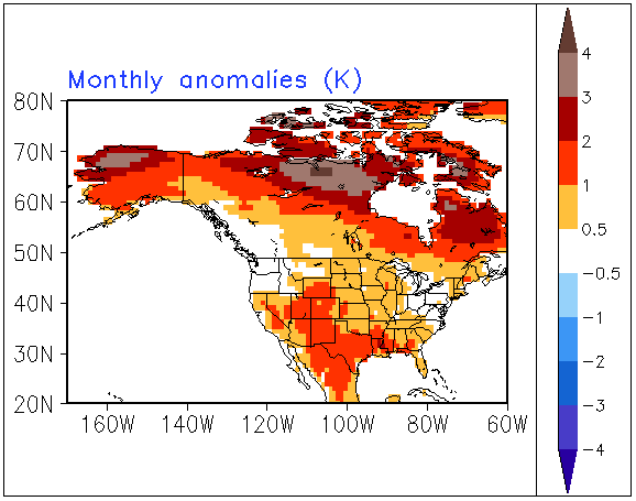
Looking ahead to May, April has a pretty strong correlation with May's temperatures (0.32 coefficient of determination). That relationship is more than twice as strong as that for March. However, that means that other variables explain 68% of May's temperatures. Therefore, the current cool start to April and possible cool monthly anomaly doesn't necessarily mean that May will wind up cooler than normal in the New York City area. So far, latest CFSv2 guidance is suggesting near normal to somewhat warmer than normal conditions for May. The ECMWF Monthly forecast run earlier this month showed a similar idea.
-
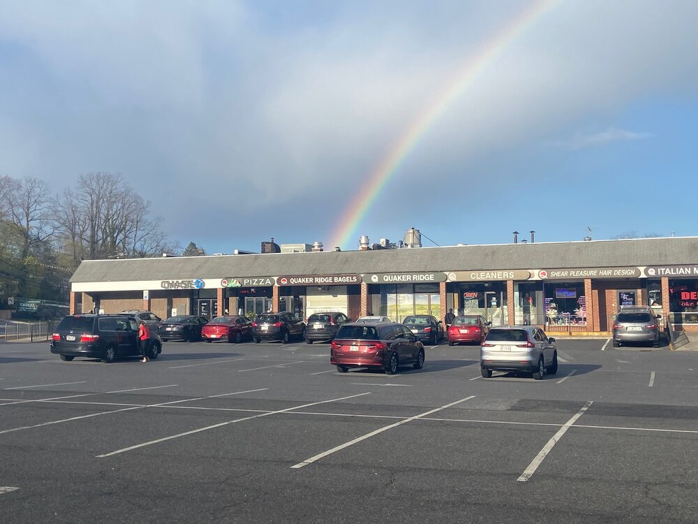
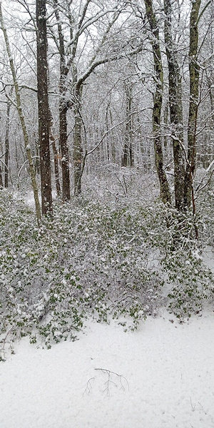
Photo from my sister in the Milford, PA area yesterday:
-
Yes, that was its latest measurable snowfall.